Path of the Vikings Combination Cruise: Copenhagen, Oslo & Quebec City
Path of the Vikings Combination Cruise: Copenhagen, Oslo & Quebec City
Cruise overview
WHY BOOK WITH US?
- ✔ The Deluxe Cruises’ team has extensive experience in ultra-luxury cruising.
- ✔ Call now to speak to our helpful and experienced Cruise Concierge team.
- ✔ Enjoy our Unique Deluxe Cruises Bonus for substantial savings.
- ✔ Our team will tailor your holiday to your exacting requirements.
- ✔ As agents, we work under the protection of each cruise lines ABTA / ATOL licences
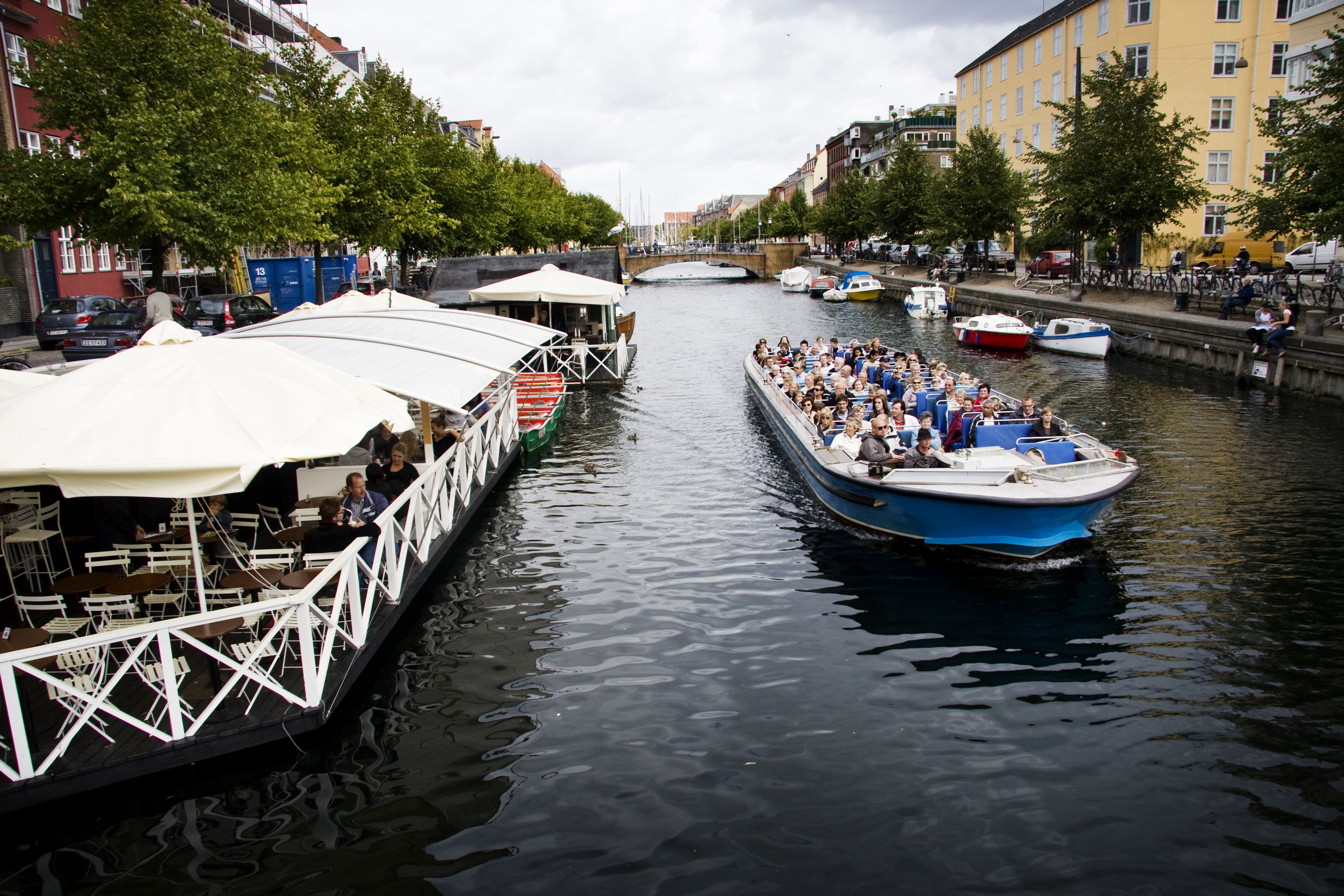
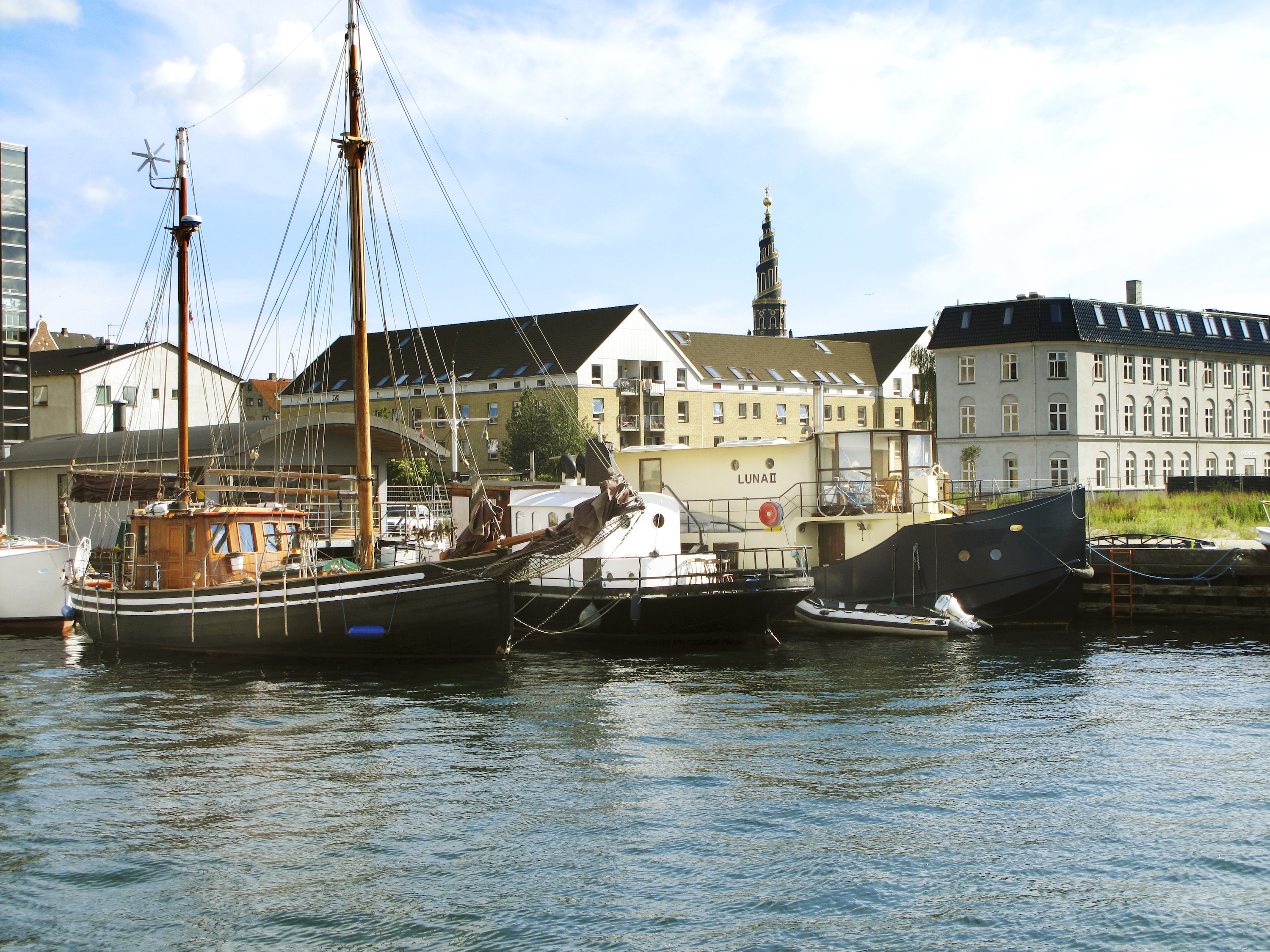
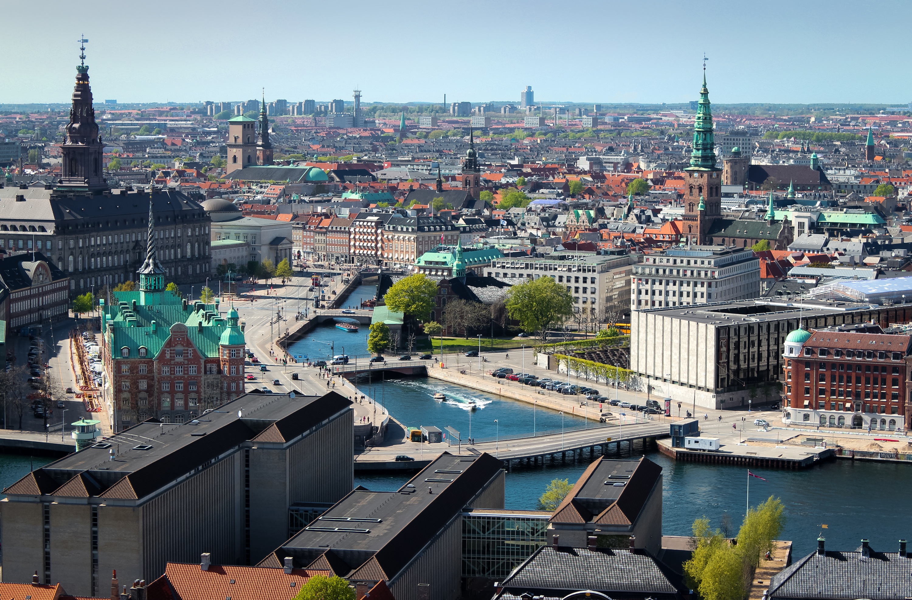
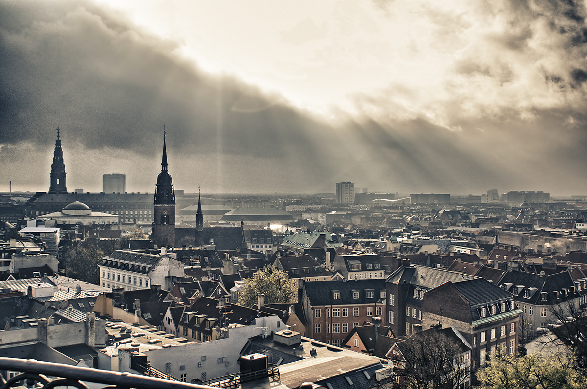
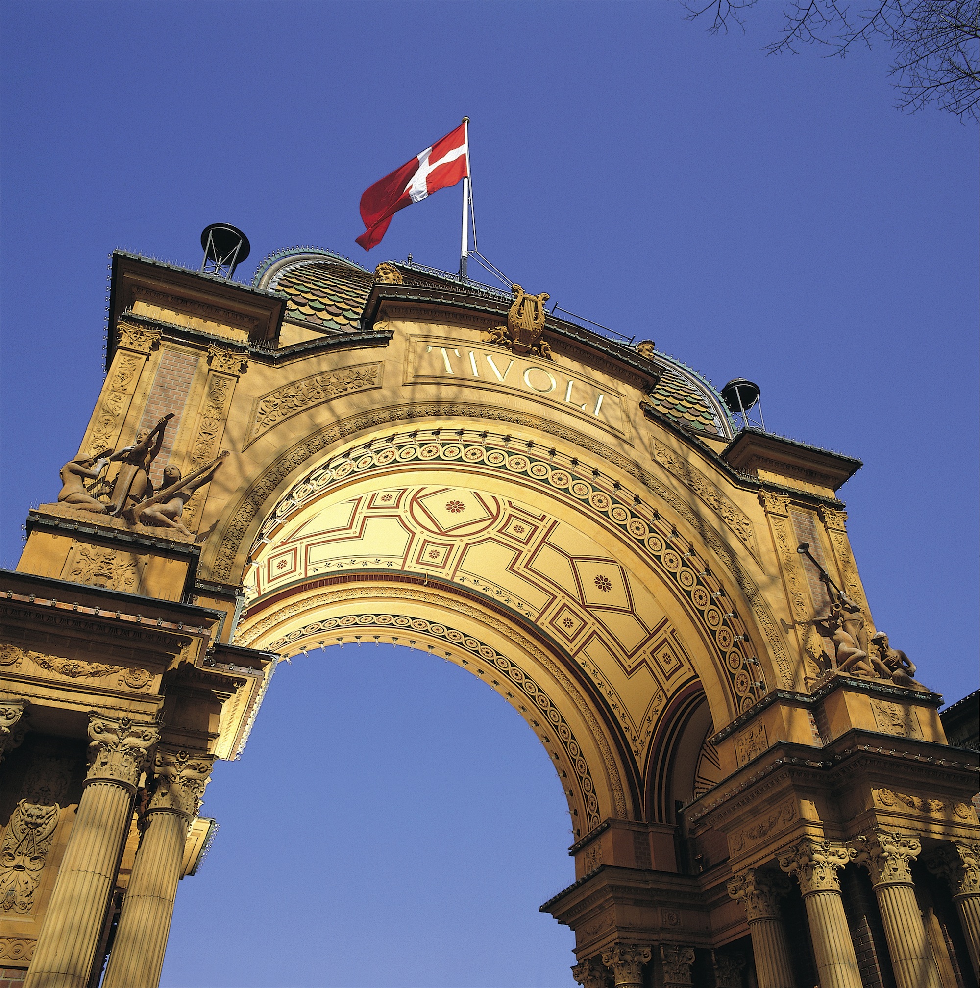
About Copenhagen
By the 11th century, Copenhagen was already an important trading and fishing centre and today you will find an attractive city which, although the largest in Scandinavia, has managed to retain its low-level skyline. Discover some of the famous attractions including Gefion Fountain and Amalienborg Palace, perhaps cruise the city’s waterways, visit Rosenborg Castle or explore the medieval fishing village of Dragoer. Once the home of Hans Christian Andersen, Copenhagen features many reminders of its fairytale heritage and lives up to the reputation immortalised in the famous song ‘Wonderful Copenhagen’.
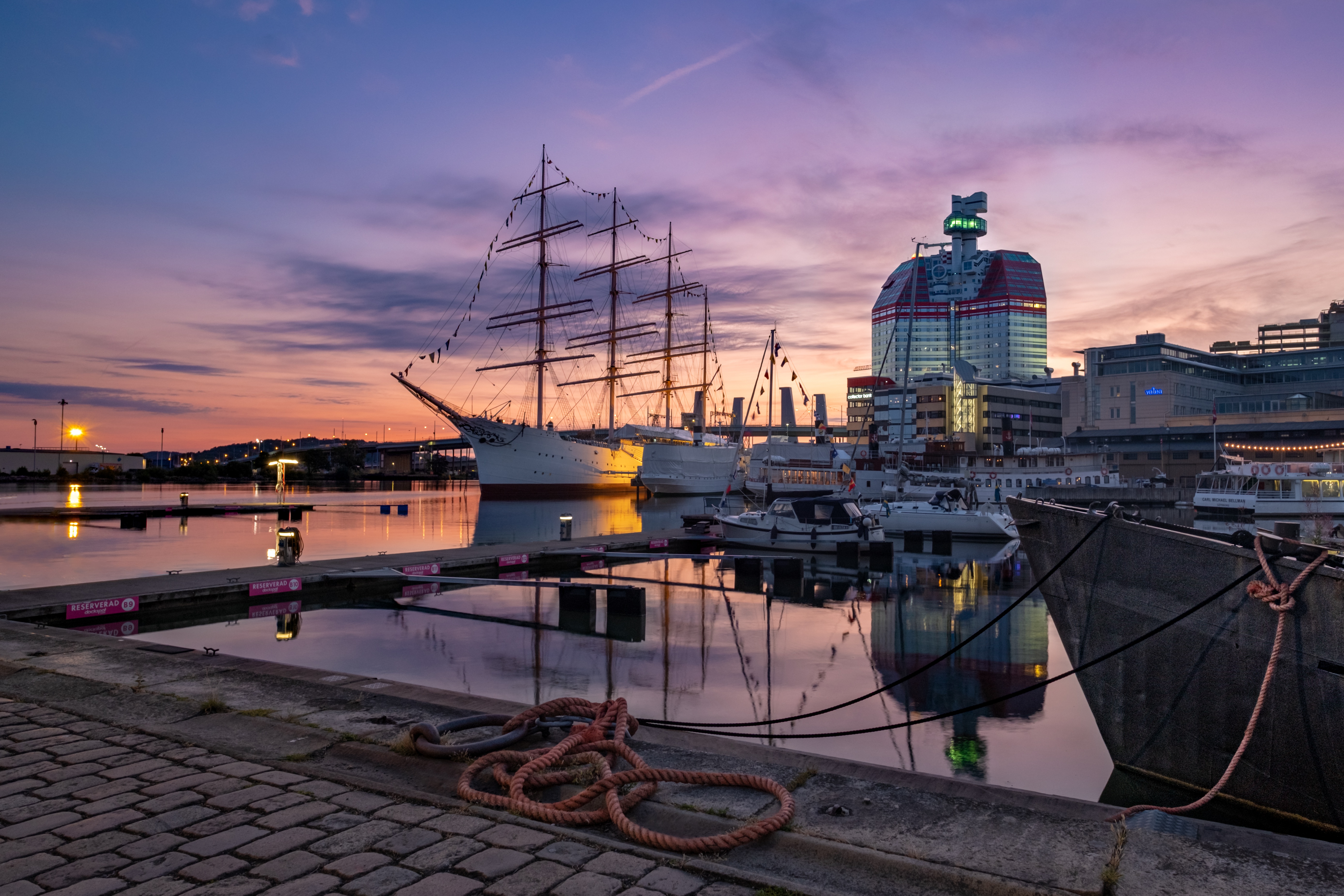
About Gothenburg
Don't tell the residents of Göteborg that they live in Sweden's "second city," but not because they will get upset (people here are known for their amiability and good humor). They just may not understand what you are talking about. People who call Göteborg (pronounced YOO-teh-bor; most visitors stick with the simpler "Gothenburg") home seem to forget that the city is diminutive in size and status compared to Stockholm.Spend a couple of days here and you'll forget, too. You'll find it's easier to ask what Göteborg hasn't got to offer rather than what it has. Culturally it is superb, boasting a fine opera house and theater, one of the country's best art museums, as well as a fantastic applied-arts museum. There's plenty of history to soak up, from the ancient port that gave the city its start to the 19th-century factory buildings and workers' houses that helped put it on the commercial map. For those looking for nature, the wild-west coast and tame green fields are both within striking distance. And don't forget the food. Since its inception in 1983, more than half of the "Swedish Chef of the Year" competition winners were cooking in Göteborg.
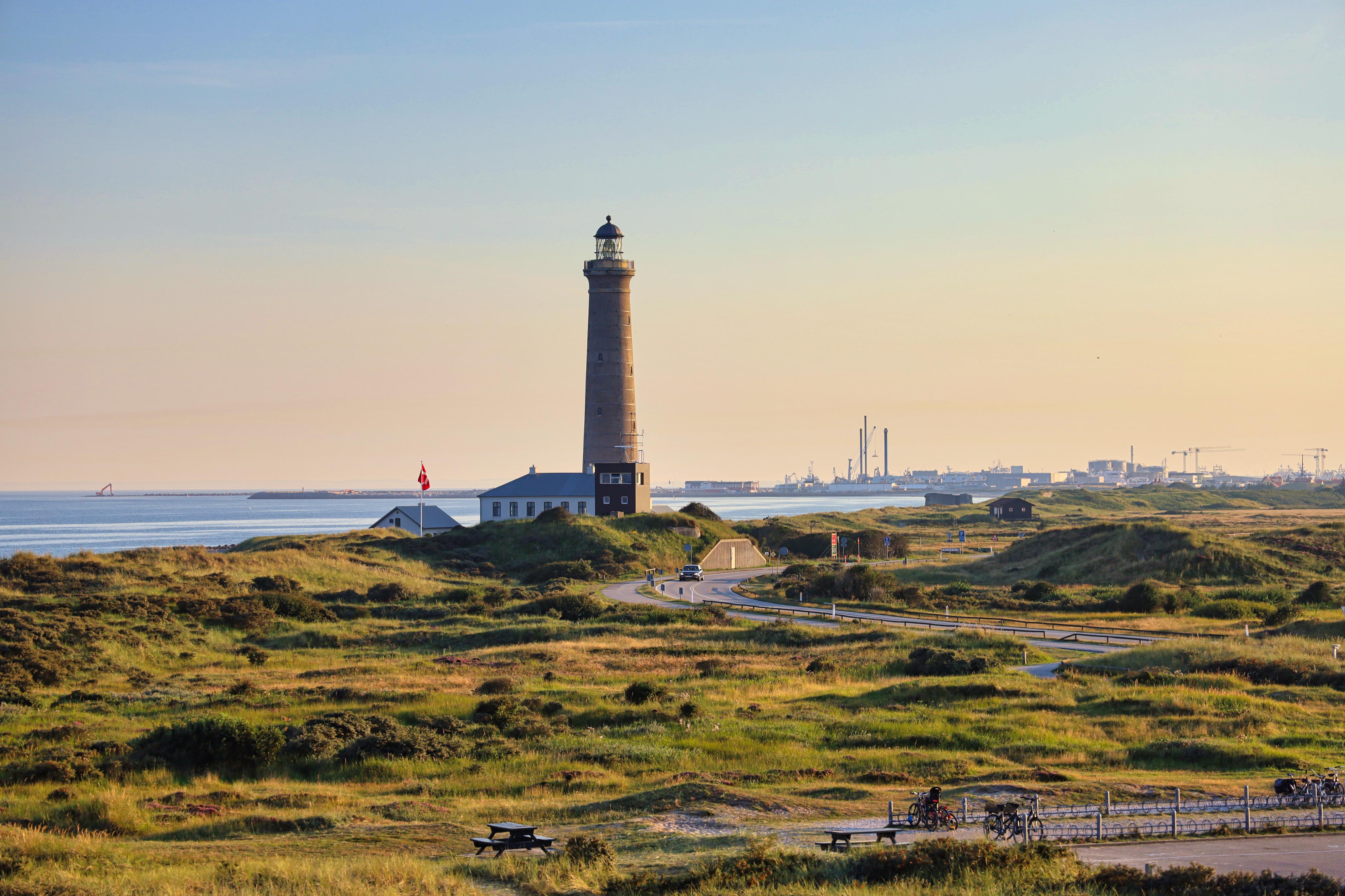
About Skagen
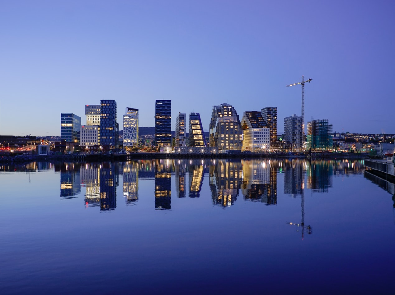
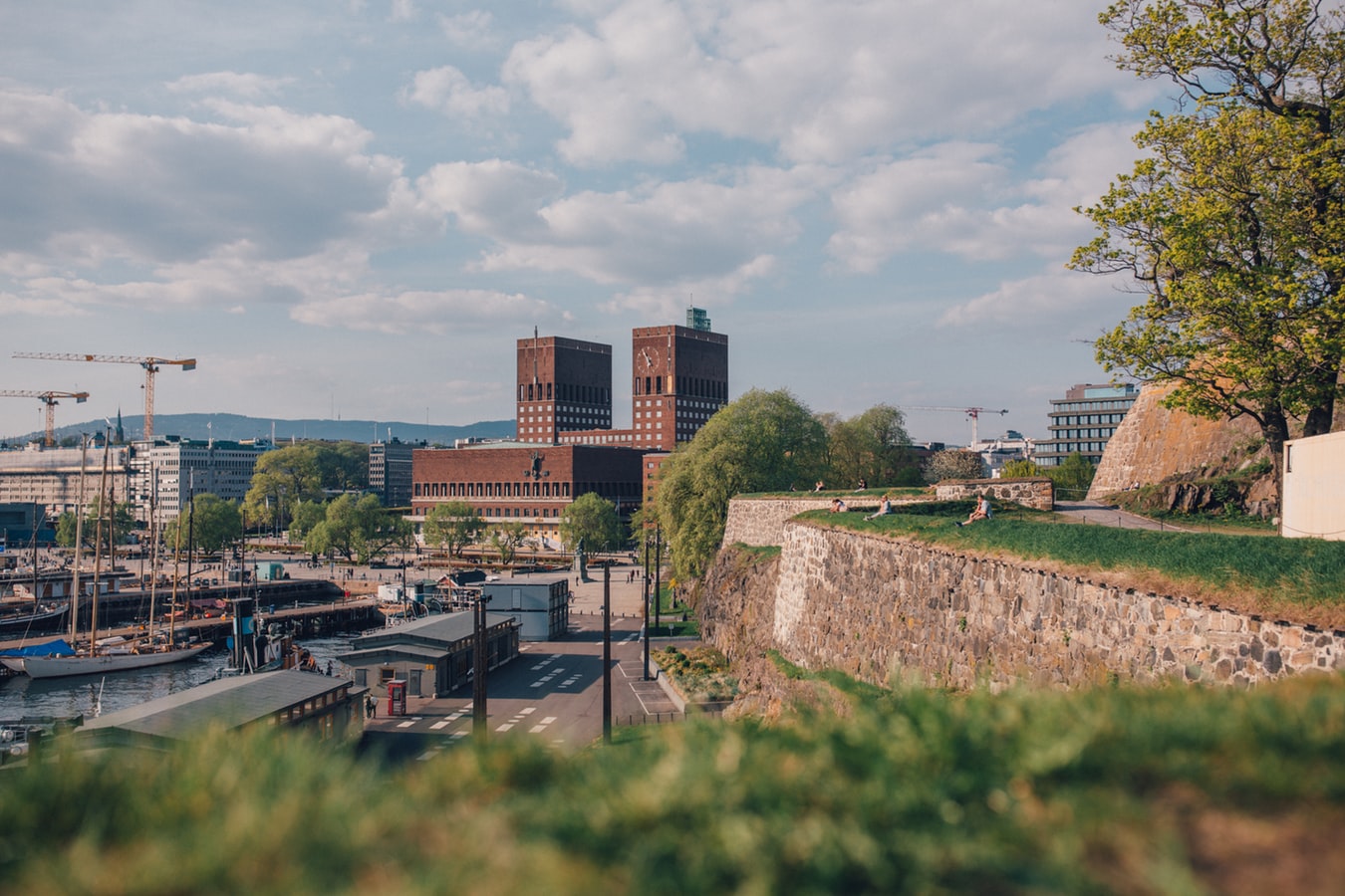
About Oslo
Oslo is the capital of Norway and is also its largest city, situated at the head of Oslo Fjord and surrounded by hills and forests. Home to some 50 museums and full of galleries, cafés, a sculpture park and the Royal Palace, this vibrant city with its handsome 19th-century buildings and wide streets has much to offer. Its history dates back 1,000 years, and includes a rich seafaring heritage that ranges from the Viking era to Thor Heyerdahl’s Kon Tiki expedition. Discover more about this exciting city on our varied selection of excursions.

About Kristiansand
Nicknamed "Sommerbyen" ("Summer City"), Norway's fifth-largest city has 78,000 inhabitants. Norwegians come here for its sun-soaked beaches and beautiful harbor. Kristiansand has also become known internationally for the outdoor Quart Festival, which hosts local and international rock bands every July. According to legend, in 1641 King Christian IV marked the four corners of Kristiansand with his walking stick, and within that framework the grid of wide streets was laid down. The center of town, called the Kvadraturen, still retains the grid, even after numerous fires. In the northeast corner is Posebyen, one of northern Europe's largest collections of low, connected wooden house settlements, and there's a market here every Saturday in summer. Kristiansand's Fisketorvet (fish market) is near the south corner of the town's grid, right on the sea.
About Haugesund
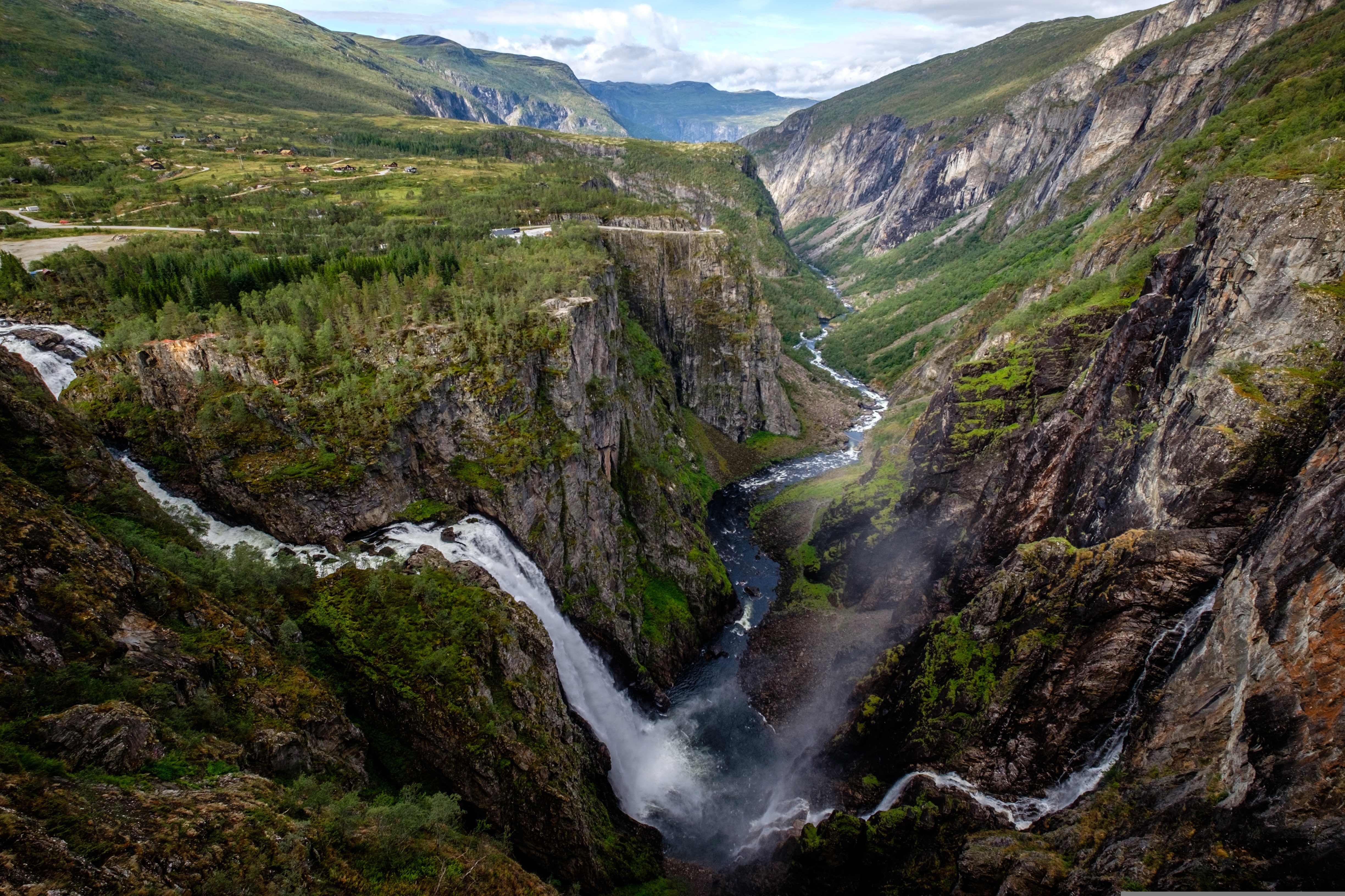
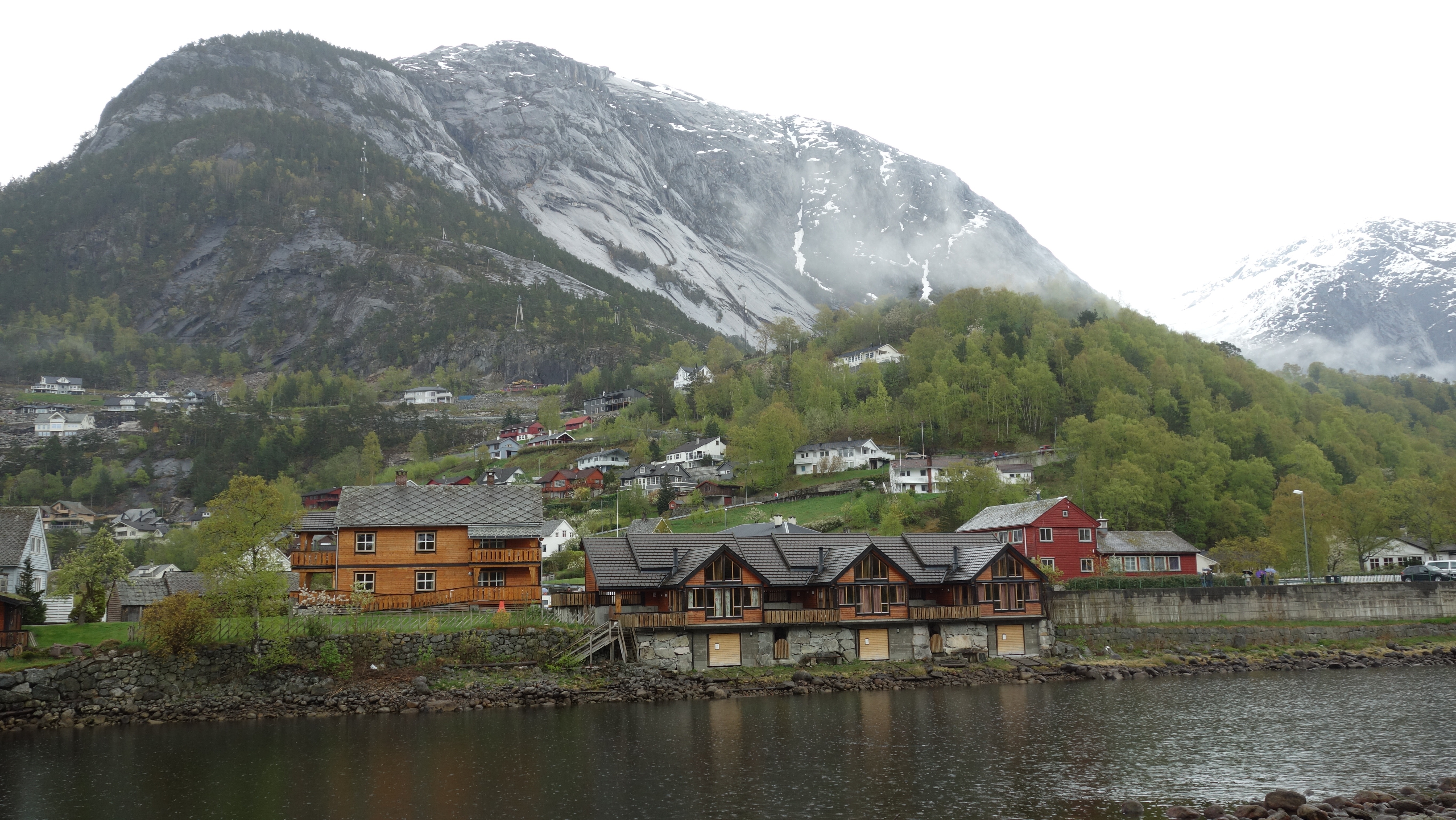
About Eidfjord
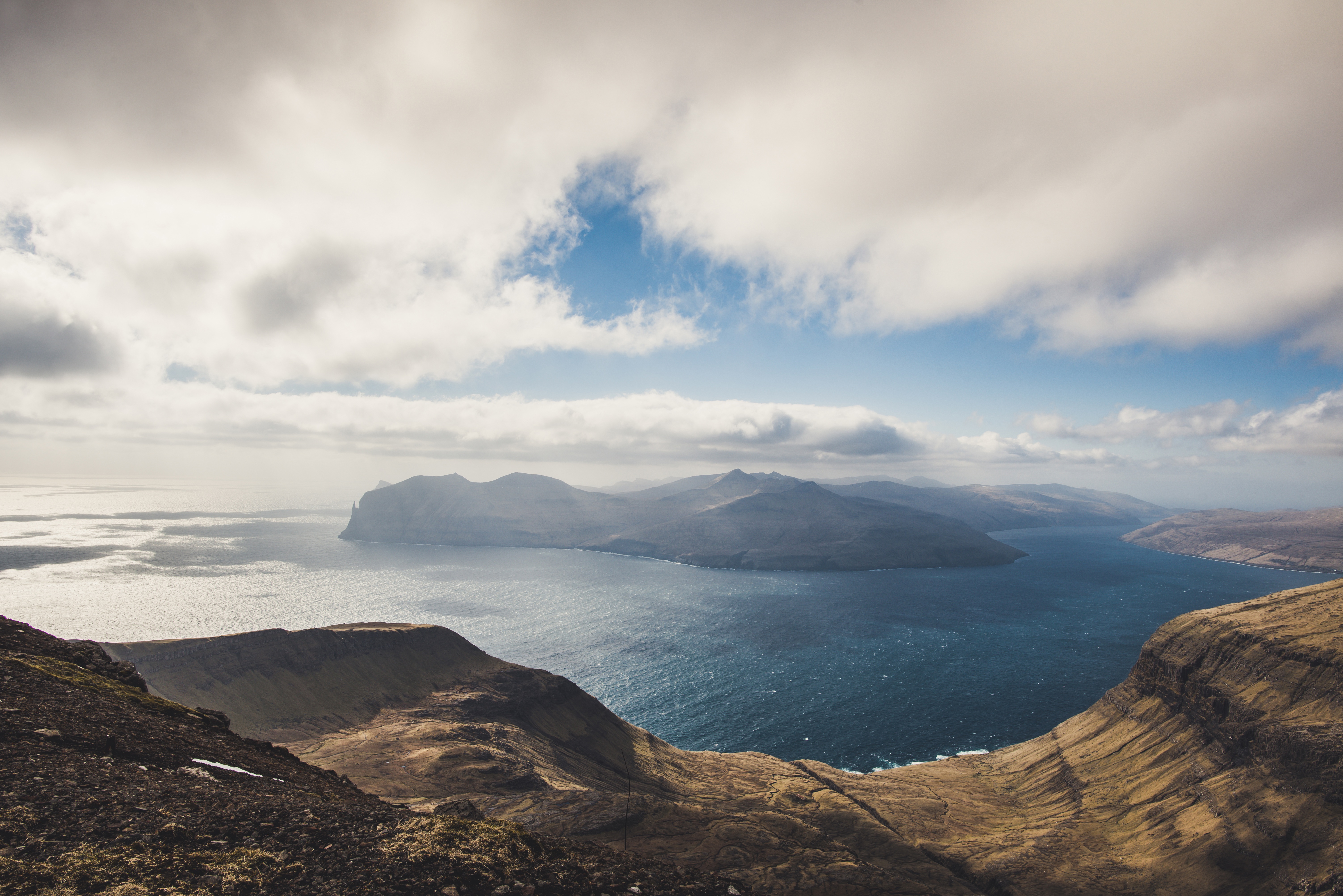
About Tórshavn
About Runavík

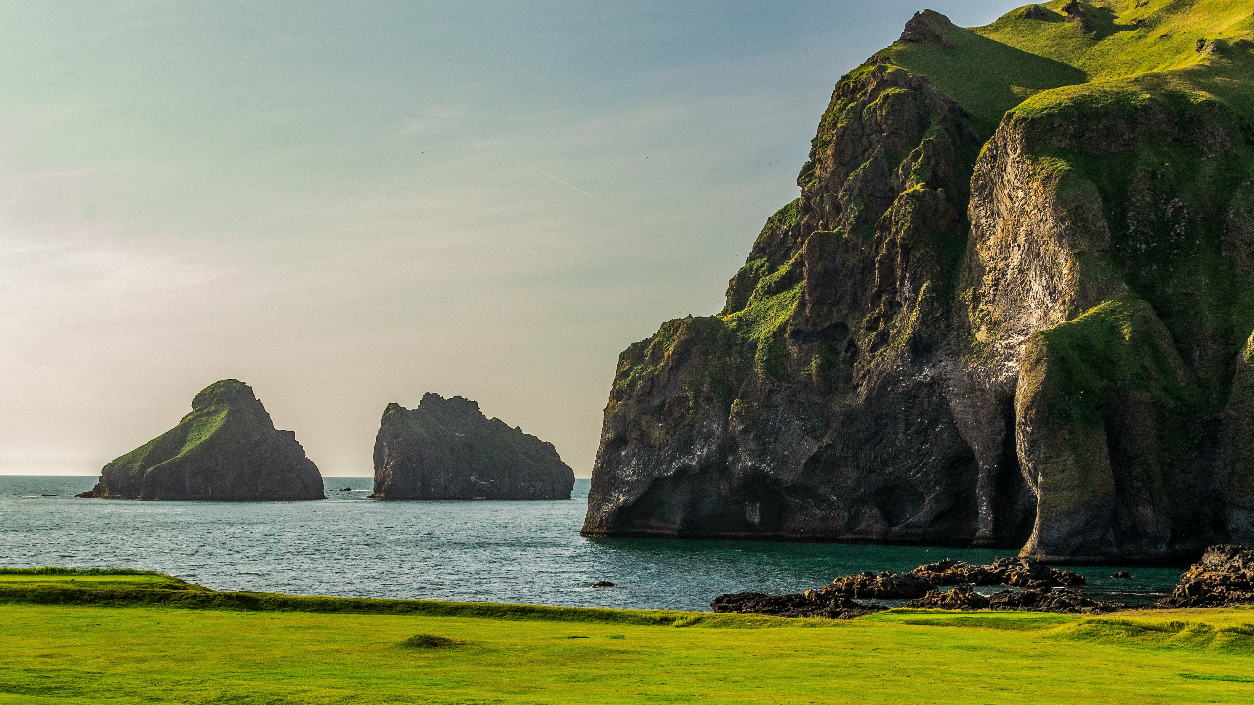
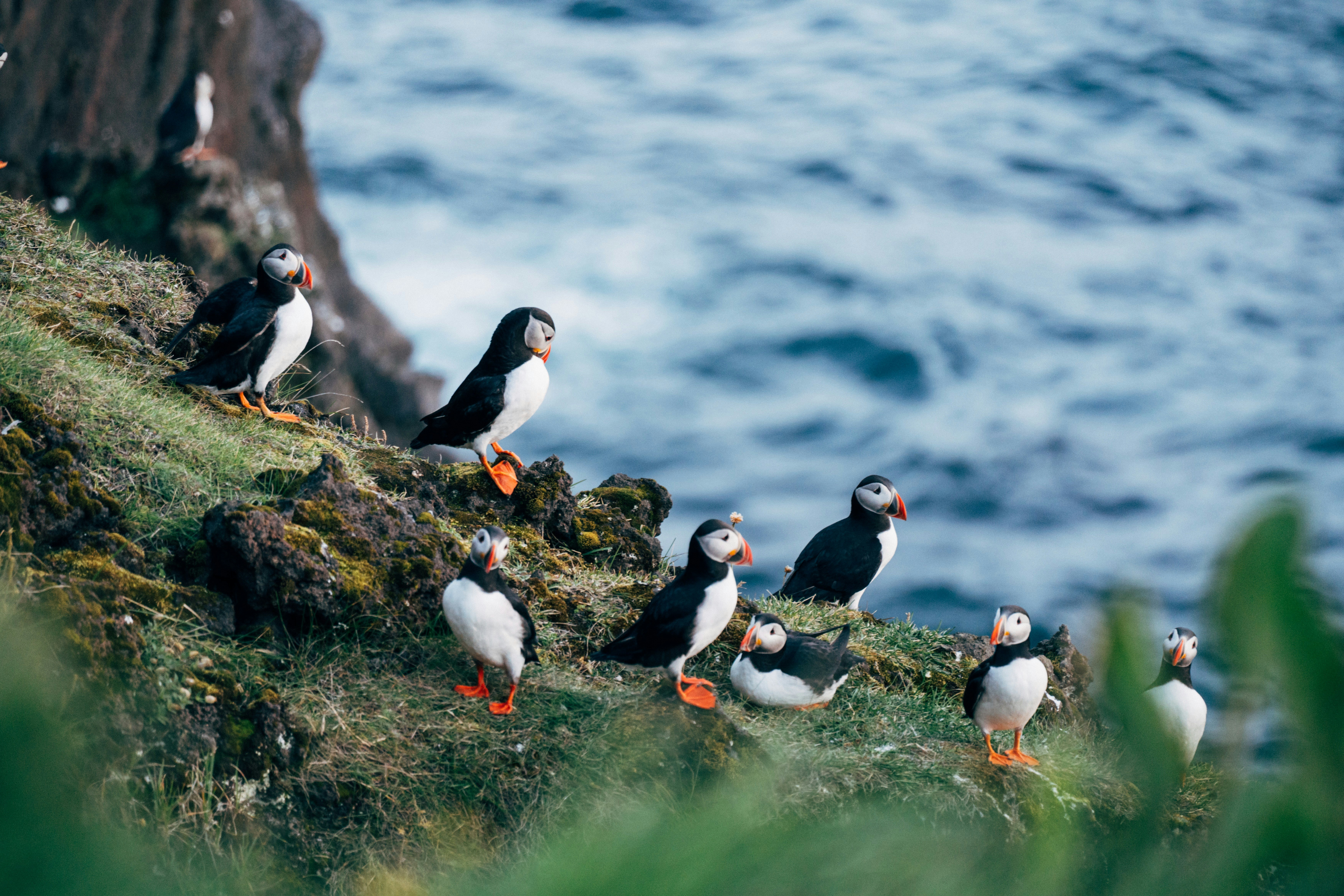
About Heimaey Island
It’s hard to imagine, as you stroll Heimaey’s idyllic streets of white wooden houses, that this island was literally torn apart by a spectacular volcanic eruption, just over 40 years ago. The fact that you can visit incredible Heimaey at all is something of a miracle – because the oozing lava of the Eldfell volcano threatened to seal the harbour off completely. Fortunately, its advance was halted by gallons of seawater, pumped onto it by the plucky islanders, who saved their fishing industry in the process. Iceland's famous for its scenery, and the huge castles of volcanic rock that rise out of the sea's waves here are some of the country's most dramatic.
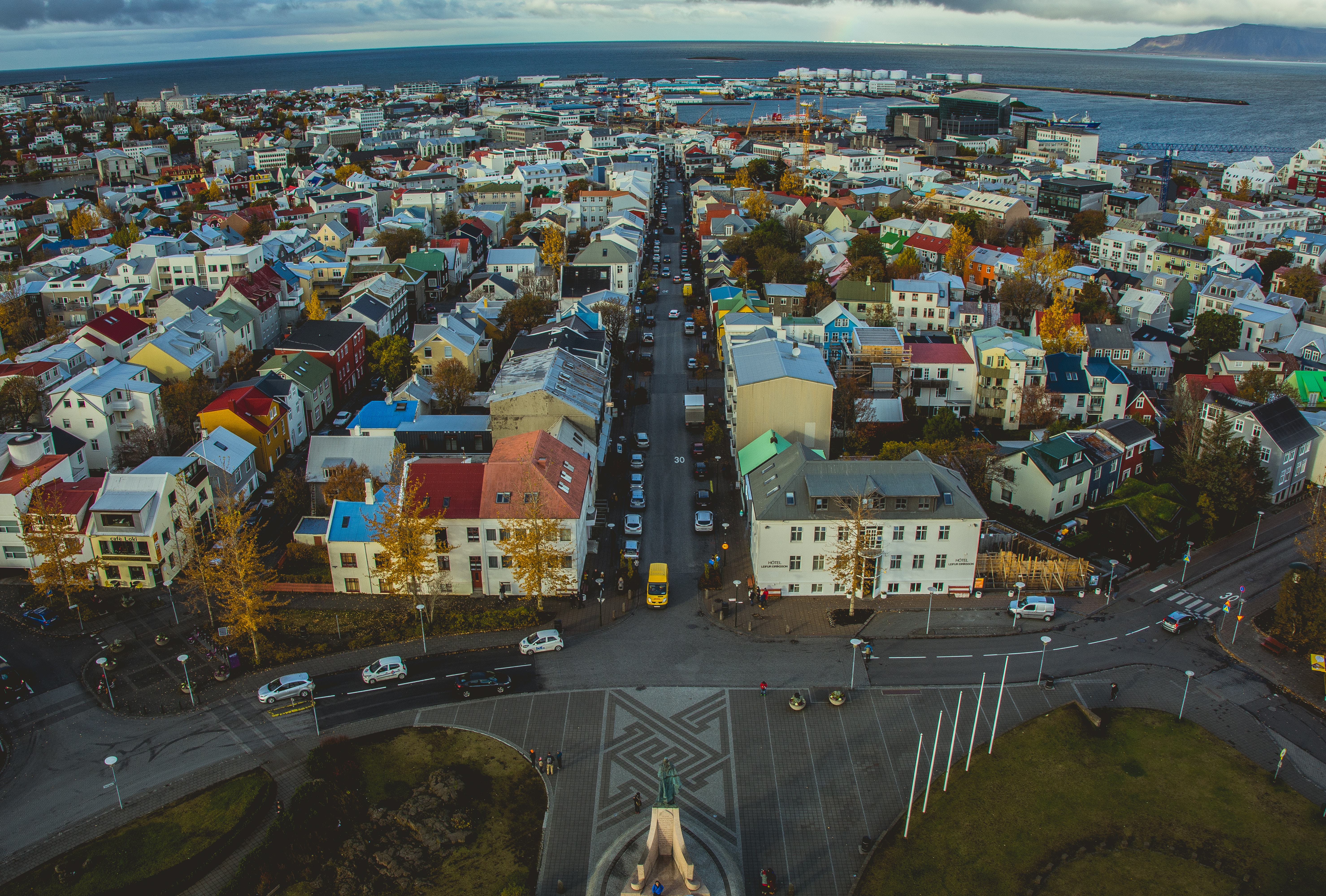
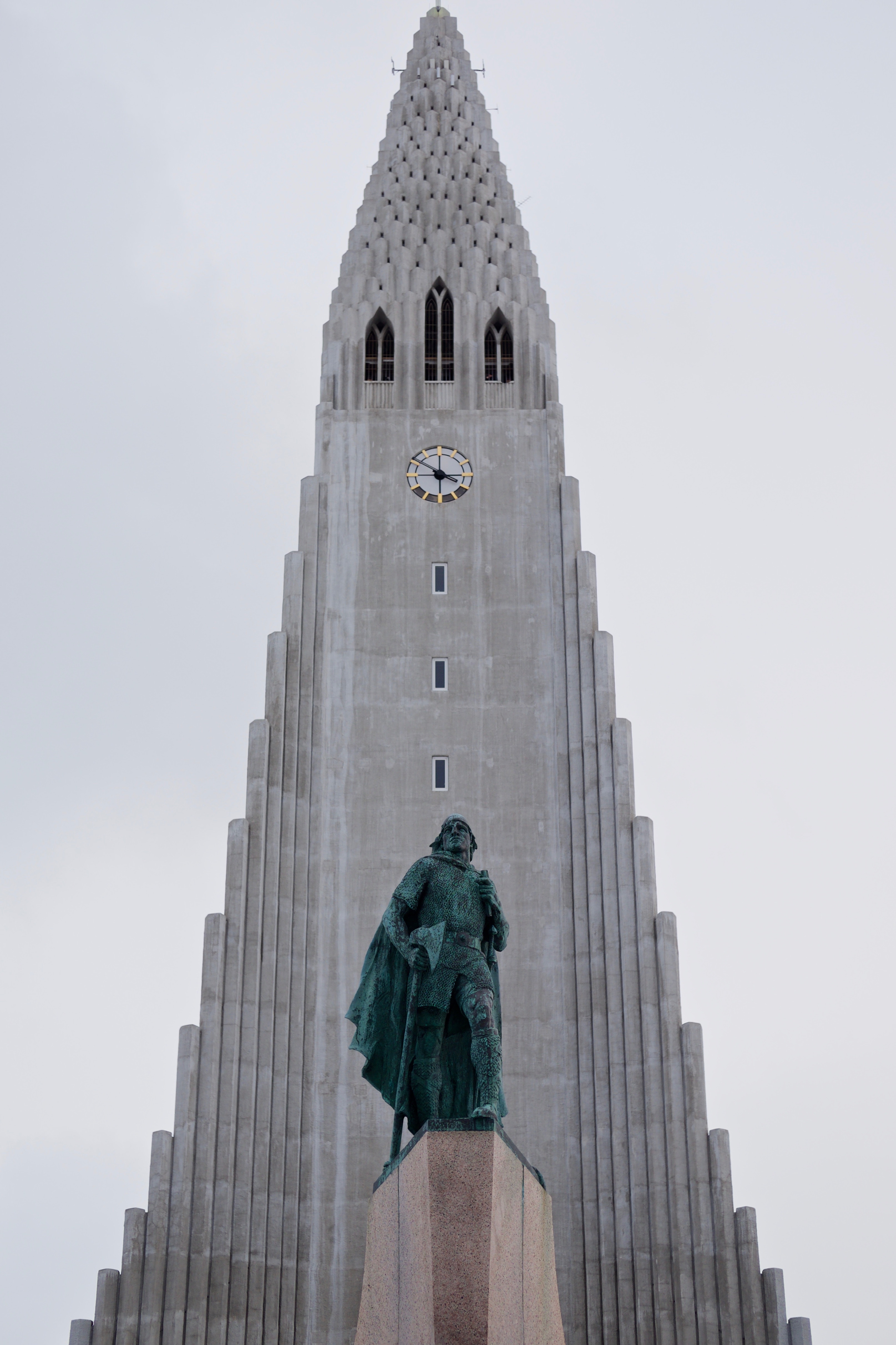
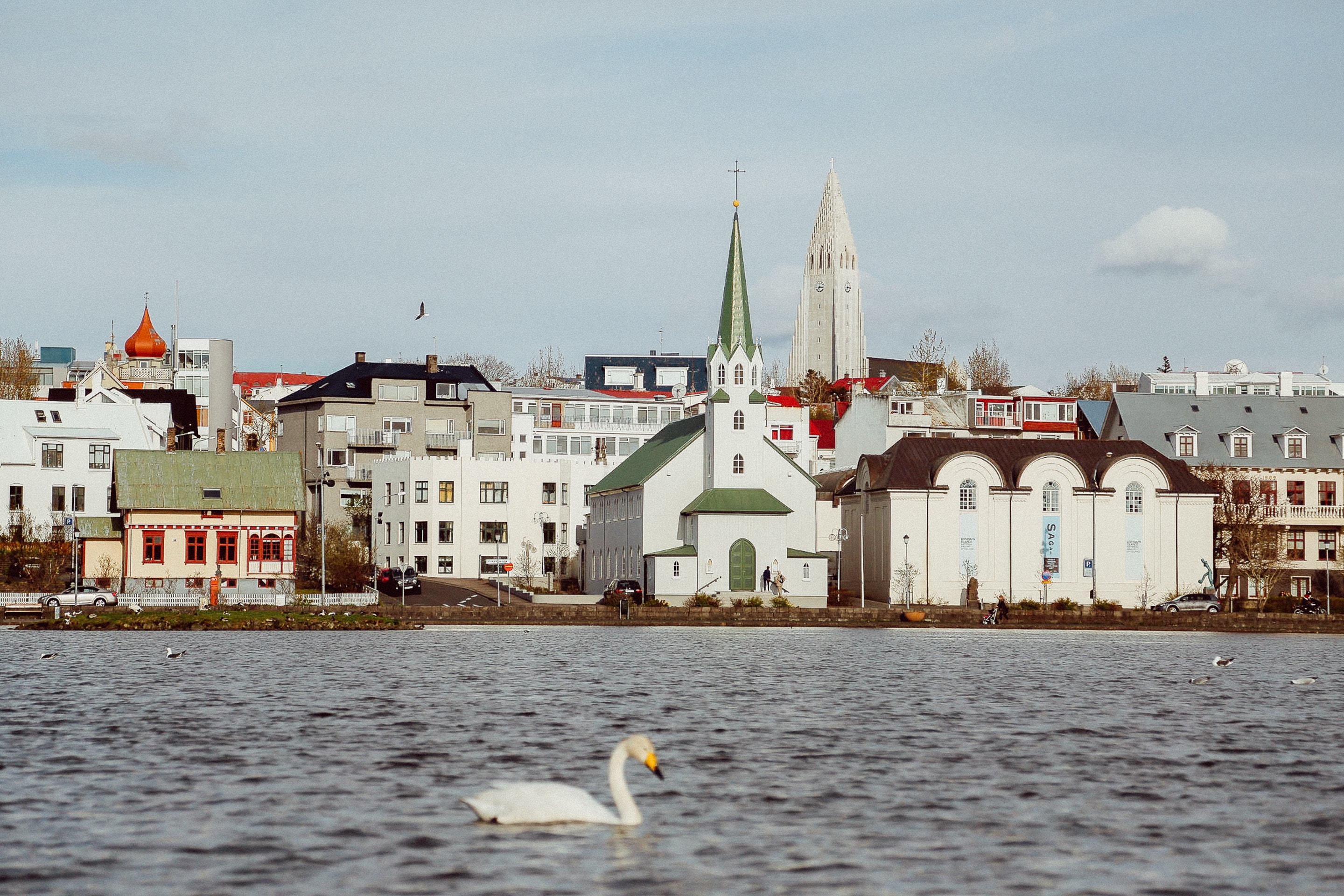
About Reykjavík
Sprawling Reykjavík, the nation's nerve center and government seat, is home to half the island's population. On a bay overlooked by proud Mt. Esja (pronounced eh-shyuh), with its ever-changing hues, Reykjavík presents a colorful sight, its concrete houses painted in light colors and topped by vibrant red, blue, and green roofs. In contrast to the almost treeless countryside, Reykjavík has many tall, native birches, rowans, and willows, as well as imported aspen, pines, and spruces.Reykjavík's name comes from the Icelandic words for smoke, reykur, and bay, vík. In AD 874, Norseman Ingólfur Arnarson saw Iceland rising out of the misty sea and came ashore at a bay eerily shrouded with plumes of steam from nearby hot springs. Today most of the houses in Reykjavík are heated by near-boiling water from the hot springs. Natural heating avoids air pollution; there's no smoke around. You may notice, however, that the hot water brings a slight sulfur smell to the bathroom.Prices are easily on a par with other major European cities. A practical option is to purchase a Reykjavík City Card at the Tourist Information Center or at the Reykjavík Youth Hostel. This card permits unlimited bus usage and admission to any of the city's seven pools, the Family Park and Zoo, and city museums. The cards are valid for one (ISK 3,300), two (ISK 4,400), or three days (ISK 4,900), and they pay for themselves after three or four uses a day. Even lacking the City Card, paying admission (ISK 500, or ISK 250 for seniors and people with disabilities) to one of the city art museums (Hafnarhús, Kjarvalsstaðir, or Ásmundarsafn) gets you free same-day admission to the other two.
About Reykjanes
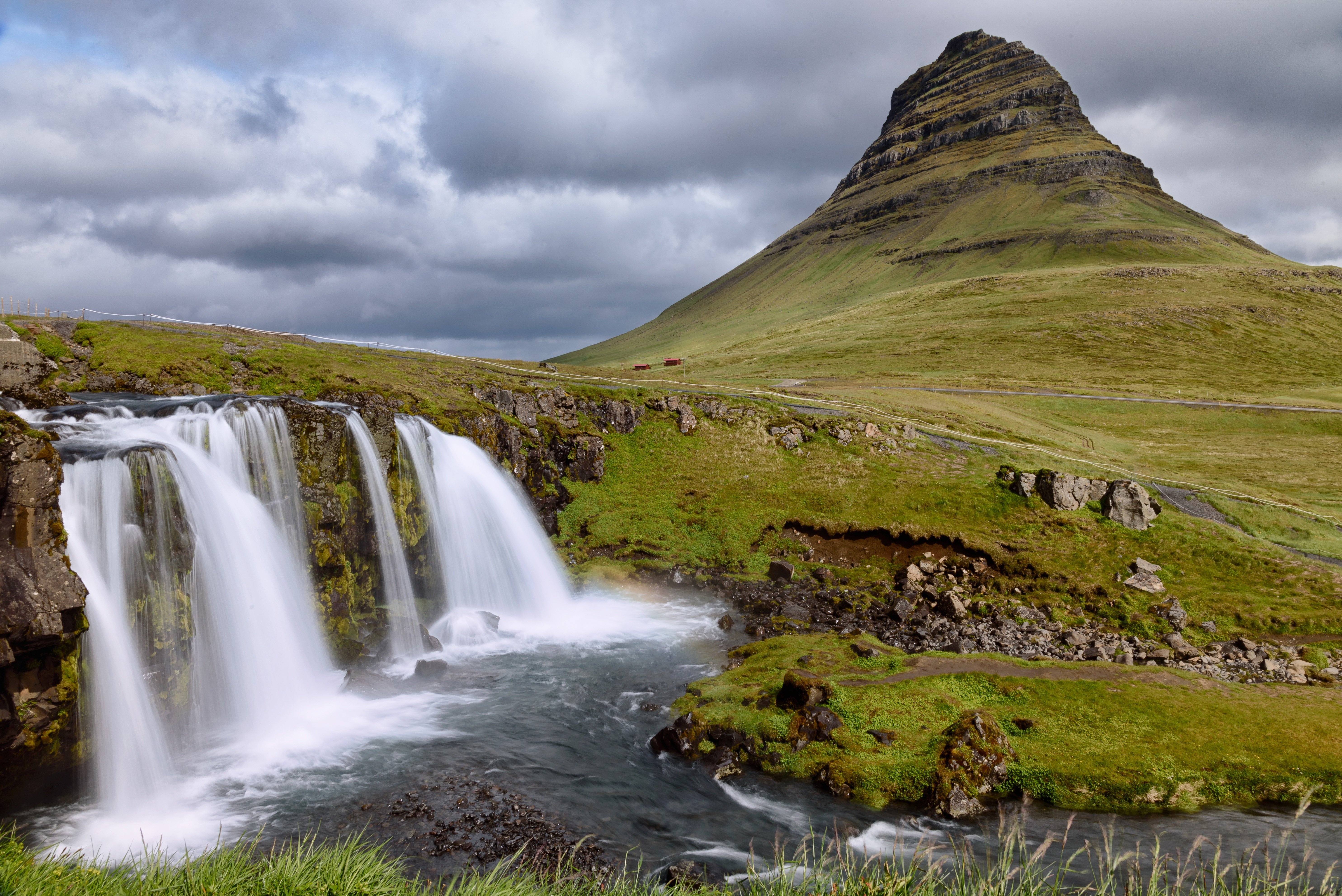
About Grundarfjørdur
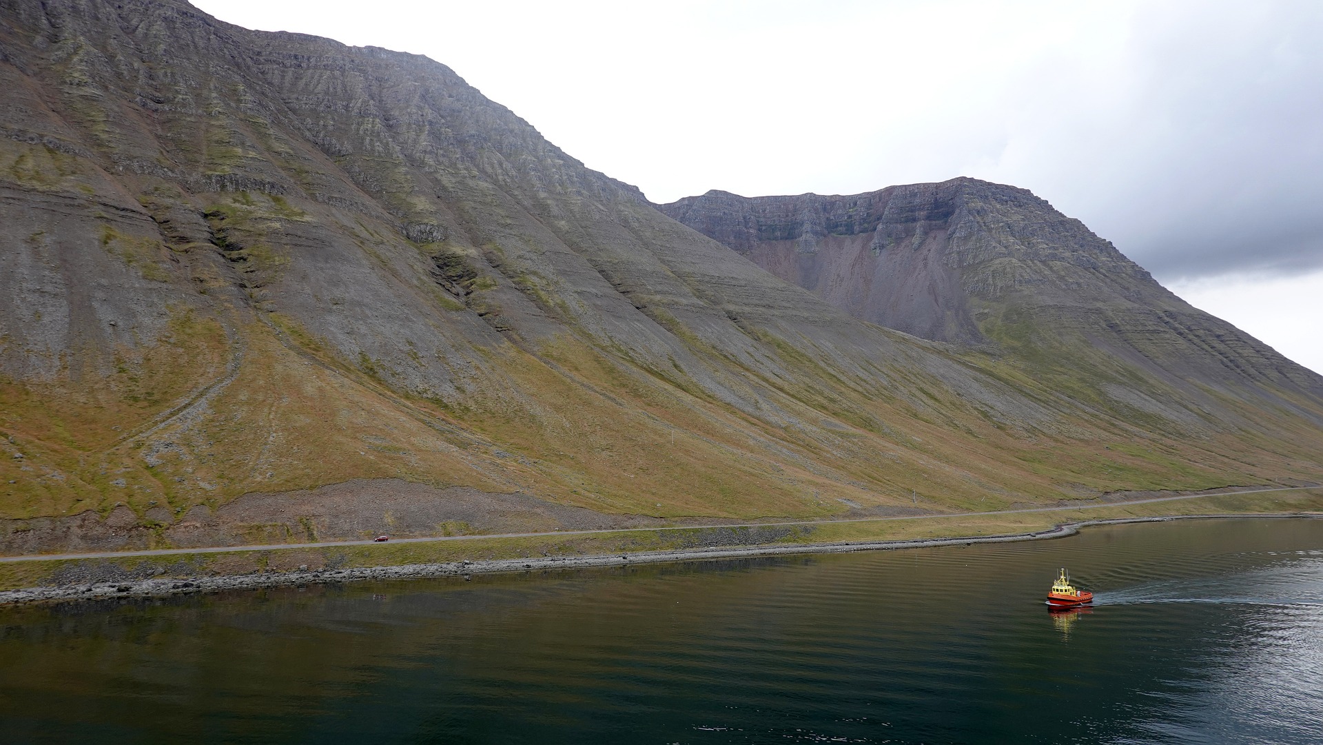
About Isafjørdur
Two colossal terraces of sheer rock stand either side of this extraordinarily located town - which rides a jutting spit onto an immensity of black fjord water. Surprisingly, considering the remoteness of its location and its compact size, Isafjordur is a modern and lively place to visit, offering a great choice of cafes and delicious restaurants – which are well stocked to impress visitors. The town is a perfectly located base for adventures amongst Iceland's fantastic wilderness - with skiing, hiking and water-sports popular pursuits among visitors.
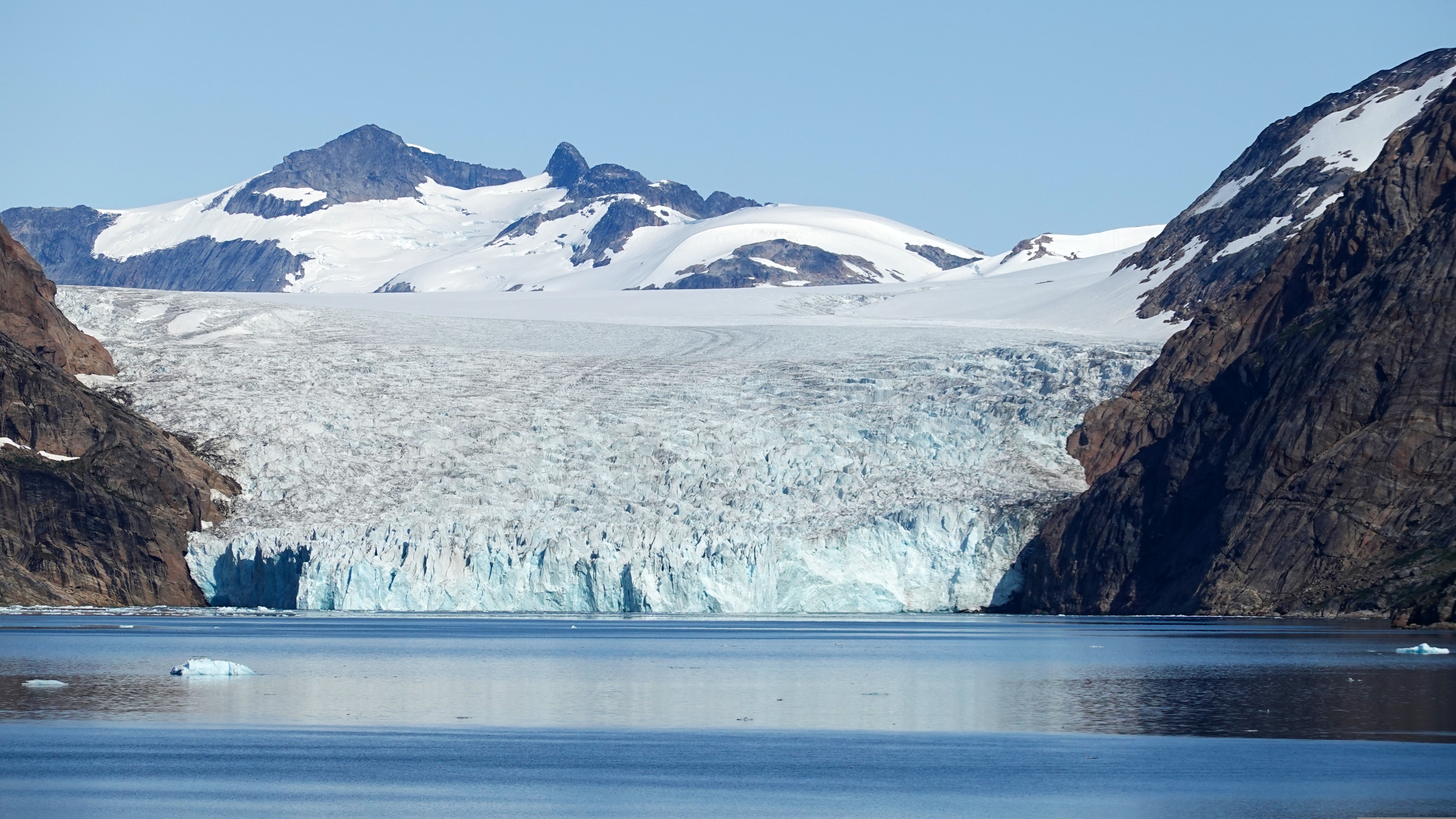
About Prince Christian Sound
The transit through the Sound is one of this voyage’s highlights. Connecting the Labrador Sea with the Irminger Seat, Prince Christian Sound or “Prins Christian Sund” in Danish is named after Prince (later King) Christian VII (1749-1808). 100 km (60 miles ), long and at times just 500 m (1500 ft) wide, this majestic and spectacular fiord throws you back into a Viking era – flanked by soaring snow-topped mountains, rock-strewn cliffs and rolling hills, it is as if time has stood still and one easily forgets that this is the 21st century. As you marvel at the sheer size of the mountains that surround you, with the Arctic waters lapping deceptively at the hull, revel in the silence enveloping you. Icebergs float serenely by, carrying with them the ages of time. Be sure to wear warm clothing as this is one spectacle that you do not want to miss.
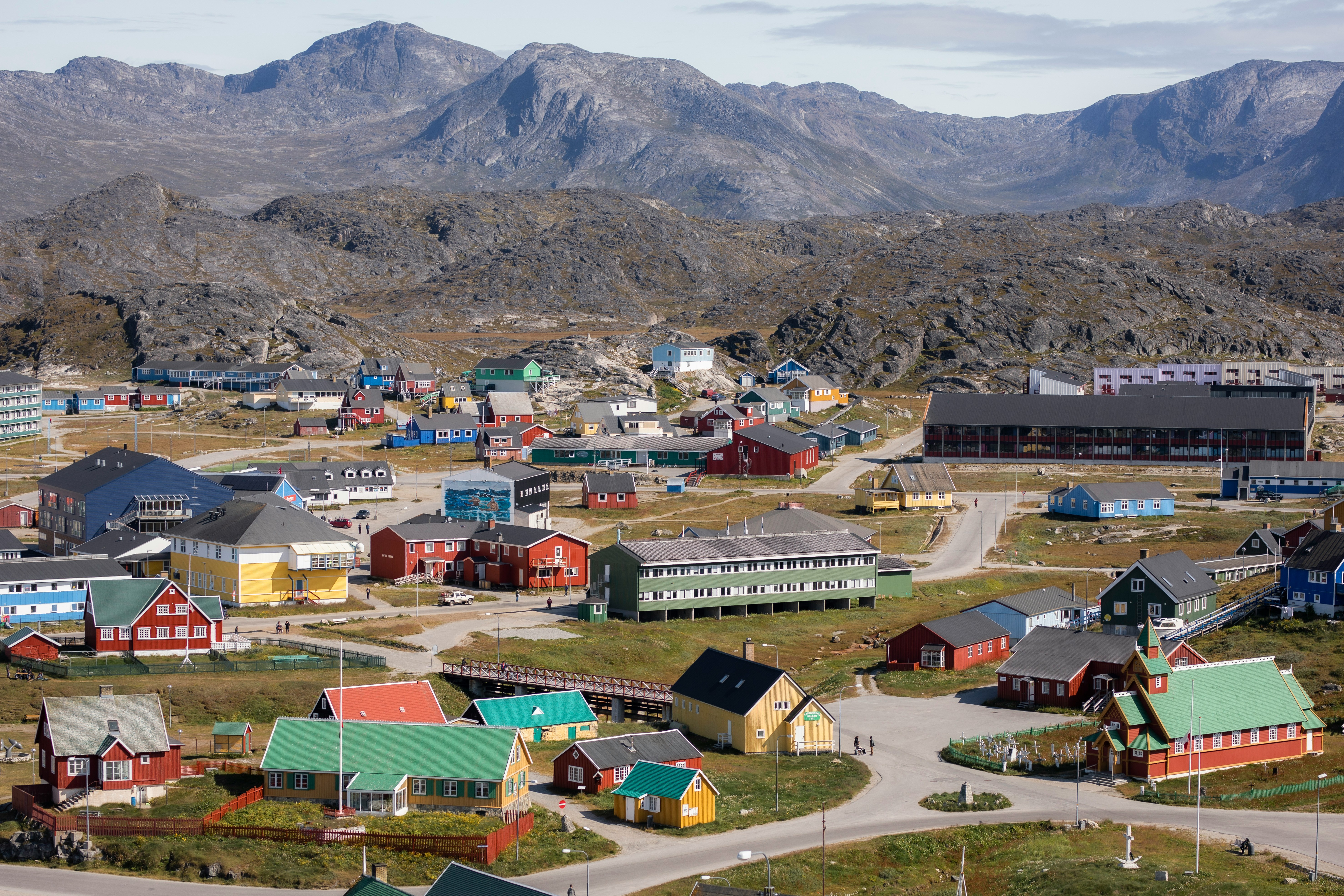
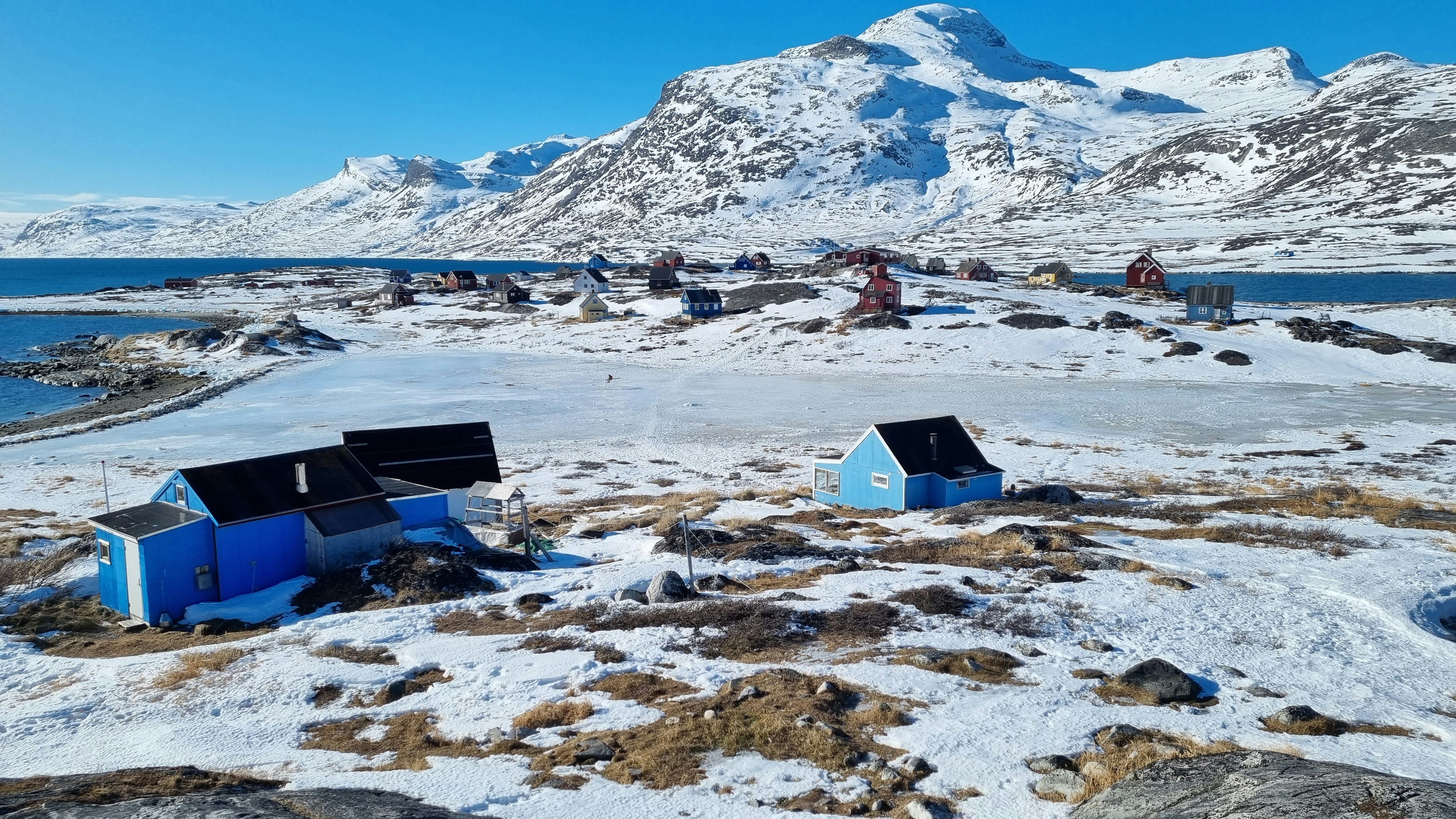
About Nanortalik
Nanortalik lies in a scenic area surrounded by steep mountainsides and is Greenland’s tenth-largest and most southerly town with less than 1500 inhabitants. The town’s name means the “place of polar bears”, which refers to the polar bears that used to be seen floating offshore on summer’s ice floes. Nanortalik has an excellent open-air museum that gives a broad picture of the region from Inuit times to today. Part of the exhibition is a summer hunting camp, where Inuit in traditional clothing describe aspects of their ancestor’s customs and lifestyle.
About Paamiut (Fredrikshaab)
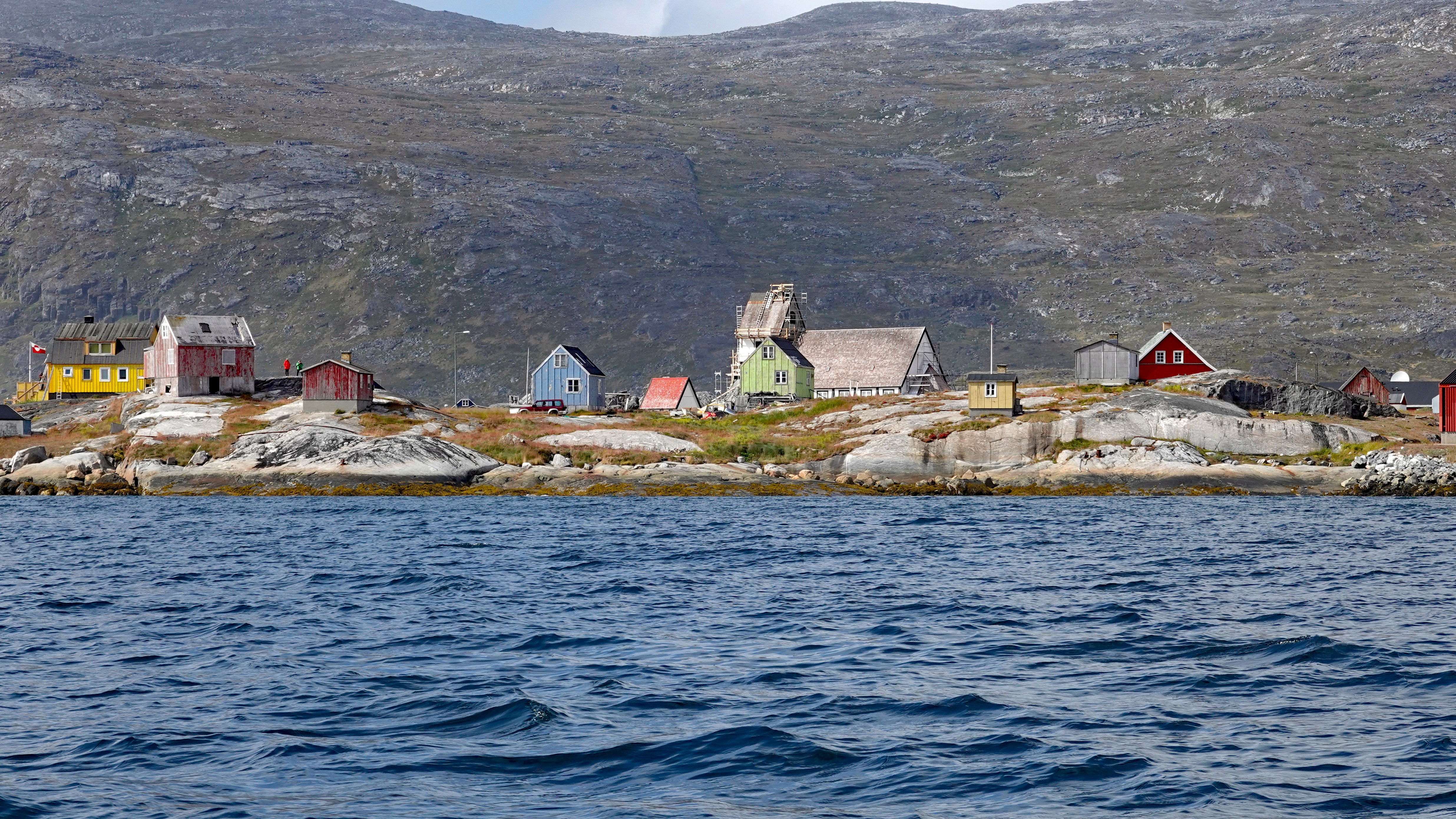
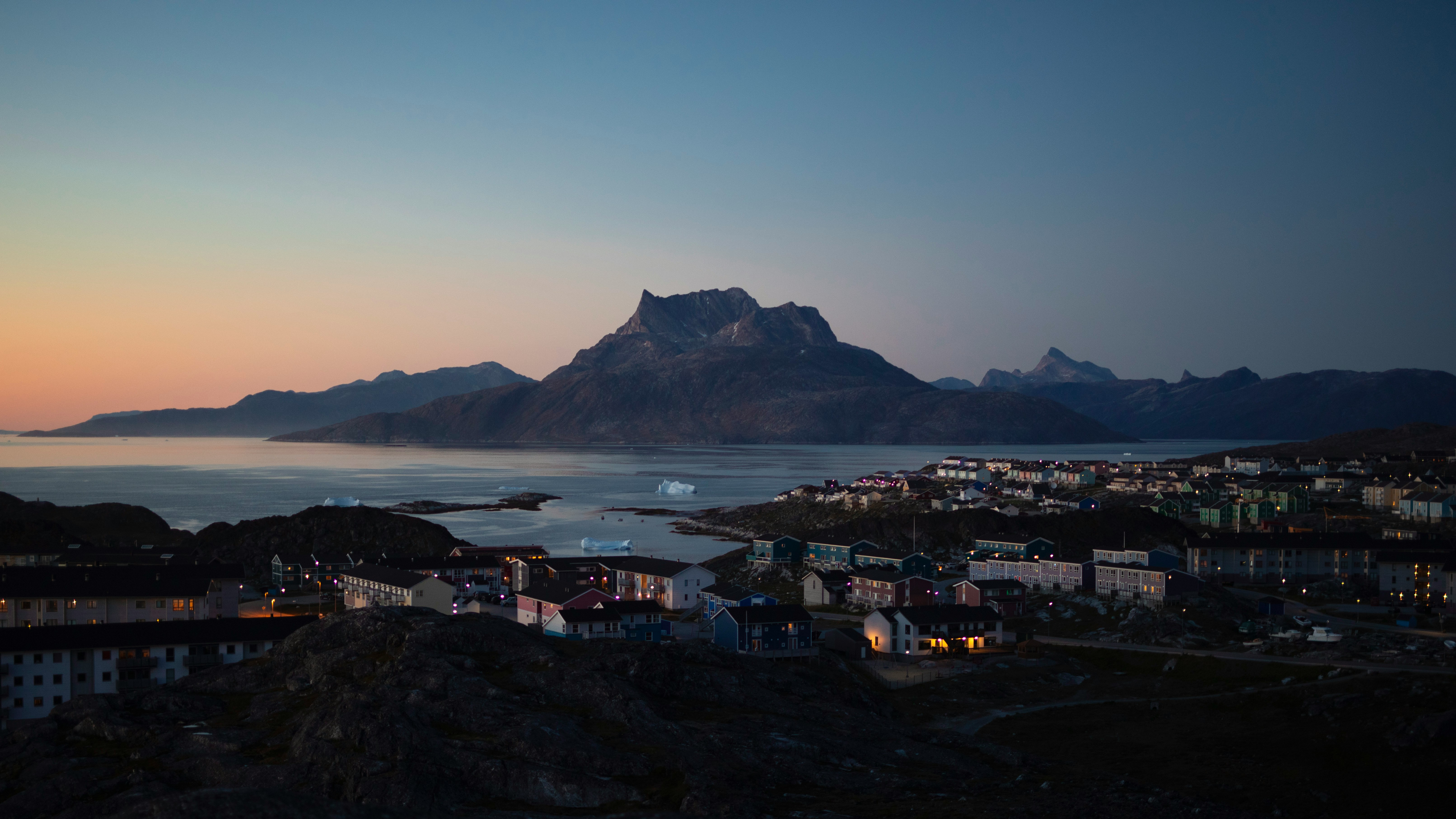
About Nuuk (Godthaab)
Nuuk, meaning “the cape”, was Greenland’s first town (1728). Started as a fort and later mission and trading post some 240 kilometers south of the Arctic Circle, it is the current capital. Almost 30% of Greenland’s population lives in the town. Not only does Nuuk have great natural beauty in its vicinity, but there are Inuit ruins, Hans Egede’s home, the parliament, and the Church of our Saviour as well. The Greenlandic National Museum has an outstanding collection of Greenlandic traditional dresses, as well as the famous Qilakitsoq mummies. The Katuaq Cultural Center’s building was inspired by the undulating Northern Lights and can house 10% of Nuuk’s inhabitants.
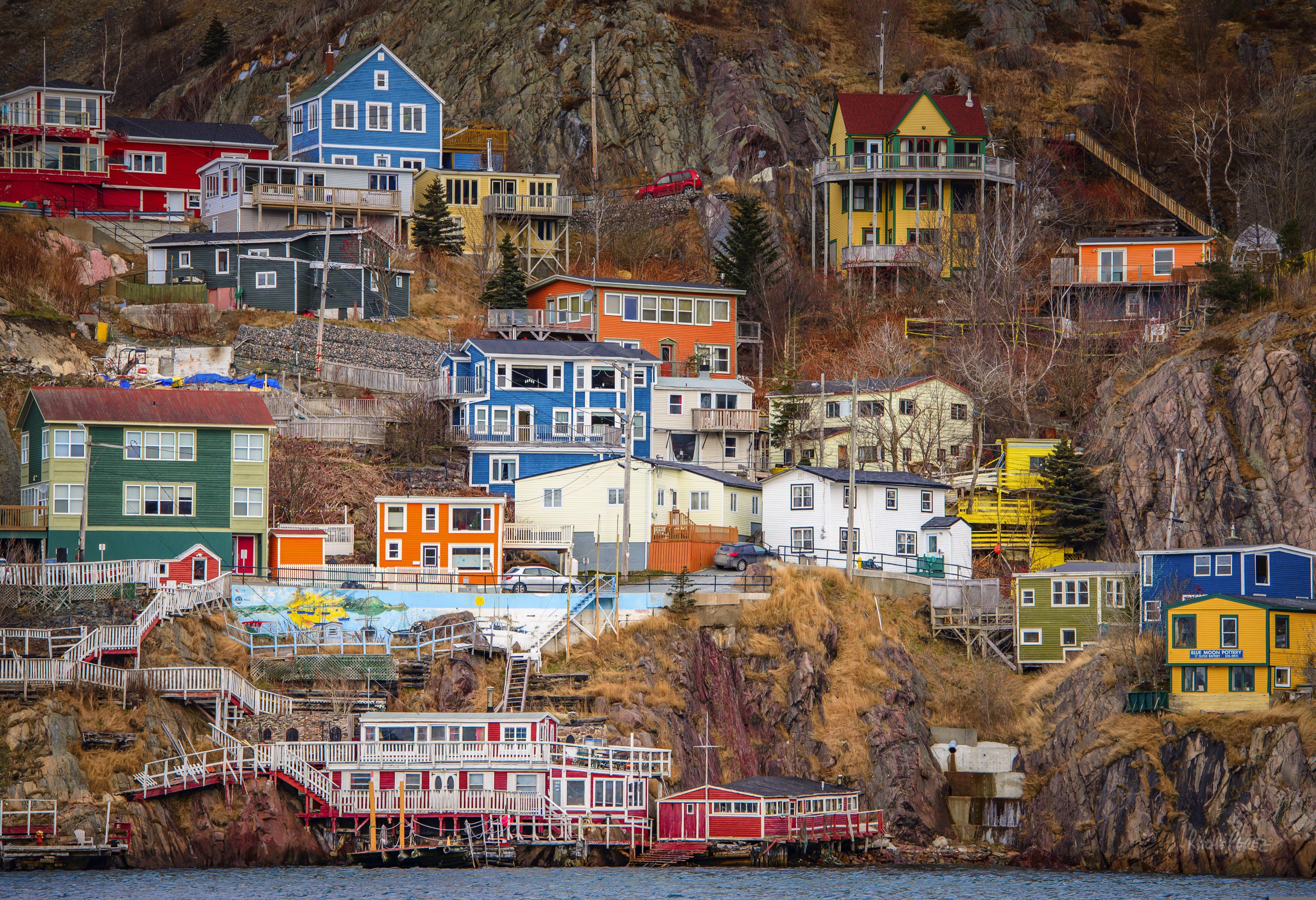
About Saint-John's, Newfoundland and Labrador
Old meets new in the province's capital (metro-area population a little more than 200,000), with modern office buildings surrounded by heritage shops and colorful row houses. St. John's mixes English and Irish influences, Victorian architecture and modern convenience, and traditional music and rock and roll into a heady brew. The arts scene is lively, but overall the city moves at a relaxed pace.For centuries, Newfoundland was the largest supplier of salt cod in the world, and St. John's Harbour was the center of the trade. As early as 1627, the merchants of Water Street—then known as the Lower Path—were doing a thriving business buying fish, selling goods, and supplying alcohol to soldiers and sailors.
About Saint Pierre
By heading almost due east from Cap-aux-Meules in Canada, it is possible to reach France in about one day’s worth of steaming! With barely 6,000 inhabitants living on tiny St. Pierre, it is the smallest French Overseas Collective. The residents of St. Pierre are predominantly descendants of Normans, Basque and Bretons and the French spoken is closer to Metropolitan French than to Canadian French. Although Basque is not spoken any longer, the influence is still felt through sport and a Basque Festival. Interestingly, this small island has two museums in part dedicated to the Prohibition. The Musée Heritage is St. Pierre’s newest museum with a focus on medical artefacts from the 19th and 20th century. Another claim to fame is a guillotine, the only one ever used in North America. In this quirky village it is easy to find the Post Office; just look for the clock tower shaped like a praying monk.
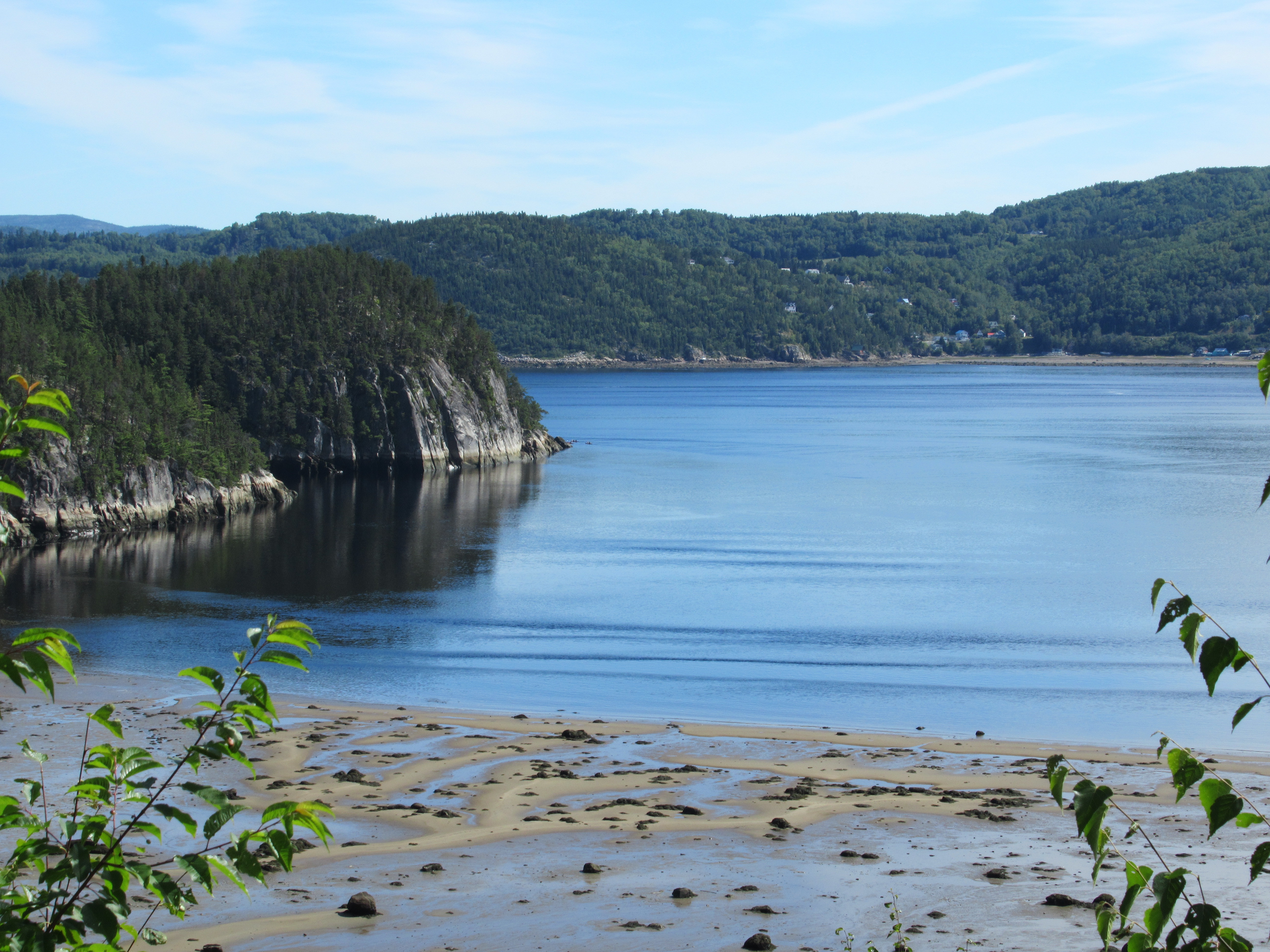
About Saguenay, Québec
Just after visiting Saguenay, the wonderful Saguenay River pours into the massive St. Lawrence River. Before then, however, it slices through one of the world's most southerly fjords and dense forests of towering pine trees. The nature watching here is nothing short of sublime, with outdoor spots like the Parc National du Fjord-du-Saguenay offering panoramic vistas and sandy river-beaches. Island-sized blue whales cruise through the waters of the mighty rivers, and flick gallons of water into the air effortlessly with a single swish of their colossal tails. With hiking, kayaking and cycling opportunities inviting you to explore the spectacular scenery - you'll find endless ways to fall in love with this majestic outdoor escape. In fall, gorgeous colours ripple through the foliage, and in doing so, they provide one of nature's greatest performances.
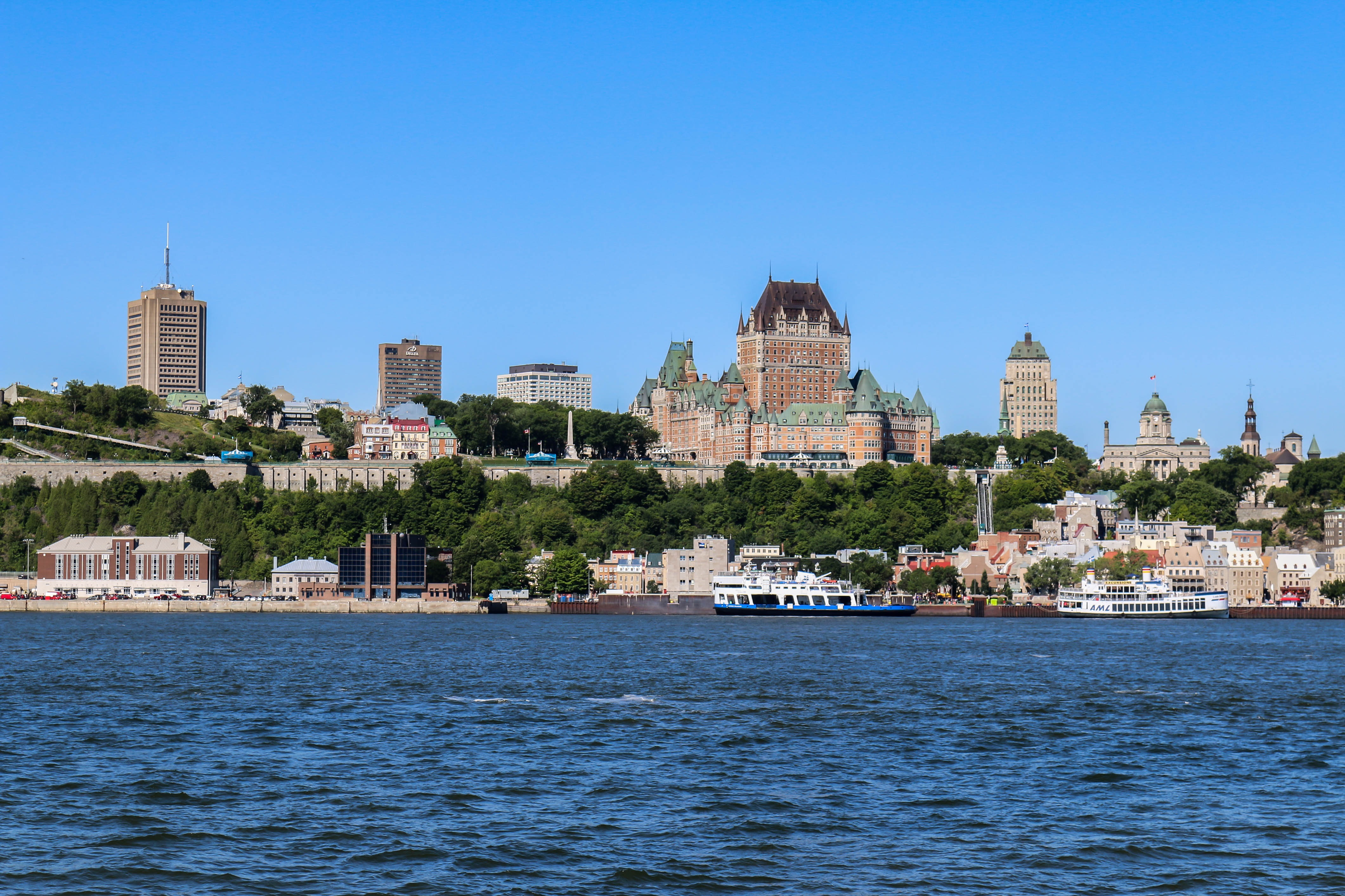
About Quebec City, Québec
Québec City's alluring setting atop Cape Diamond (Cap Diamant) evokes a past of high adventure, military history, and exploration. This French-speaking capital city is the only walled city north of Mexico. Visitors come for the delicious and inventive cuisine, the remarkable historical continuity, and to share in the seasonal exuberance of the largest Francophone population outside France.The historic heart of this community is the Old City (Vieux-Québec), comprising the part of Upper Town (Haute-Ville) surrounded by walls and Lower Town (Basse-Ville), which spreads out at the base of the hill from Place Royale. Many sets of staircases and the popular funicular link the top of the hill with the bottom. Cobblestone streets, horse-drawn carriages, and elaborate cathedrals here are charming in all seasons. The Old City earned recognition as an official UNESCO World Heritage site in 1985, thanks largely to city planners who managed to update and preserve the 400-year-old buildings and attractions without destroying what made them worth preserving. The most familiar icon of the city, Fairmont Château Frontenac, is set on the highest point in Upper Town, where it holds court over the entire city.Sitting proudly above the confluence of the St. Lawrence and St. Charles rivers, the city's famous military fortification, La Citadelle, built in the early 19th century, remains the largest of its kind in North America. In summer, visitors should try to catch the Changing of the Guard, held every morning at 10 am; you can get much closer to the guards here than at Buckingham Palace in London.Enchanting as it is, the Old City is just a small part of the true Québec City experience. Think outside the walls and explore St-Roch, a downtown hot spot, which has artsy galleries, foodie haunts, and a bustling square. Cruise the Grande-Allée and avenue Cartier to find a livelier part of town dotted with nightclubs and fun eateries. Or while away the hours in St-Jean-Baptiste, a neighborhood with trendy shops and hipster hangouts.
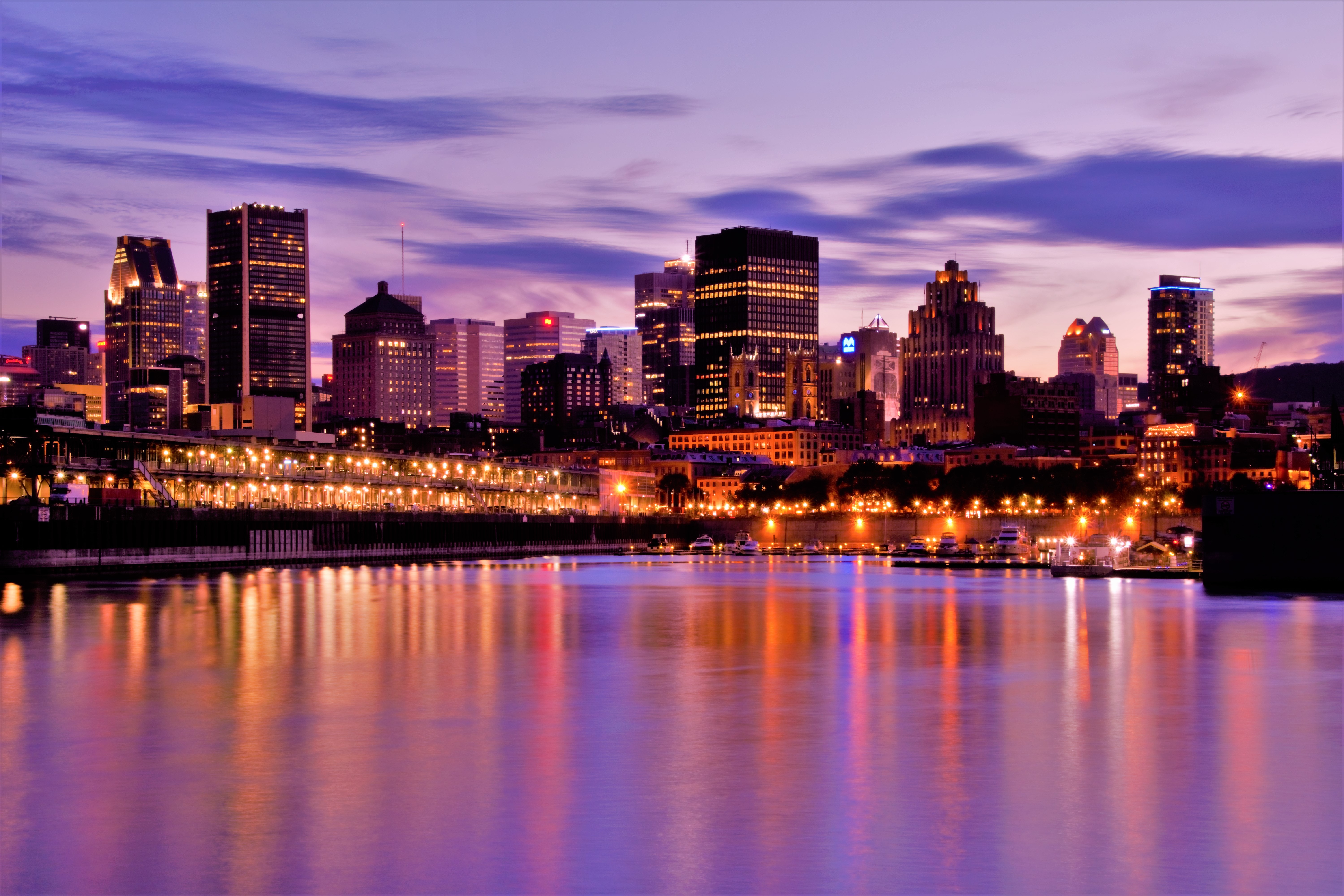
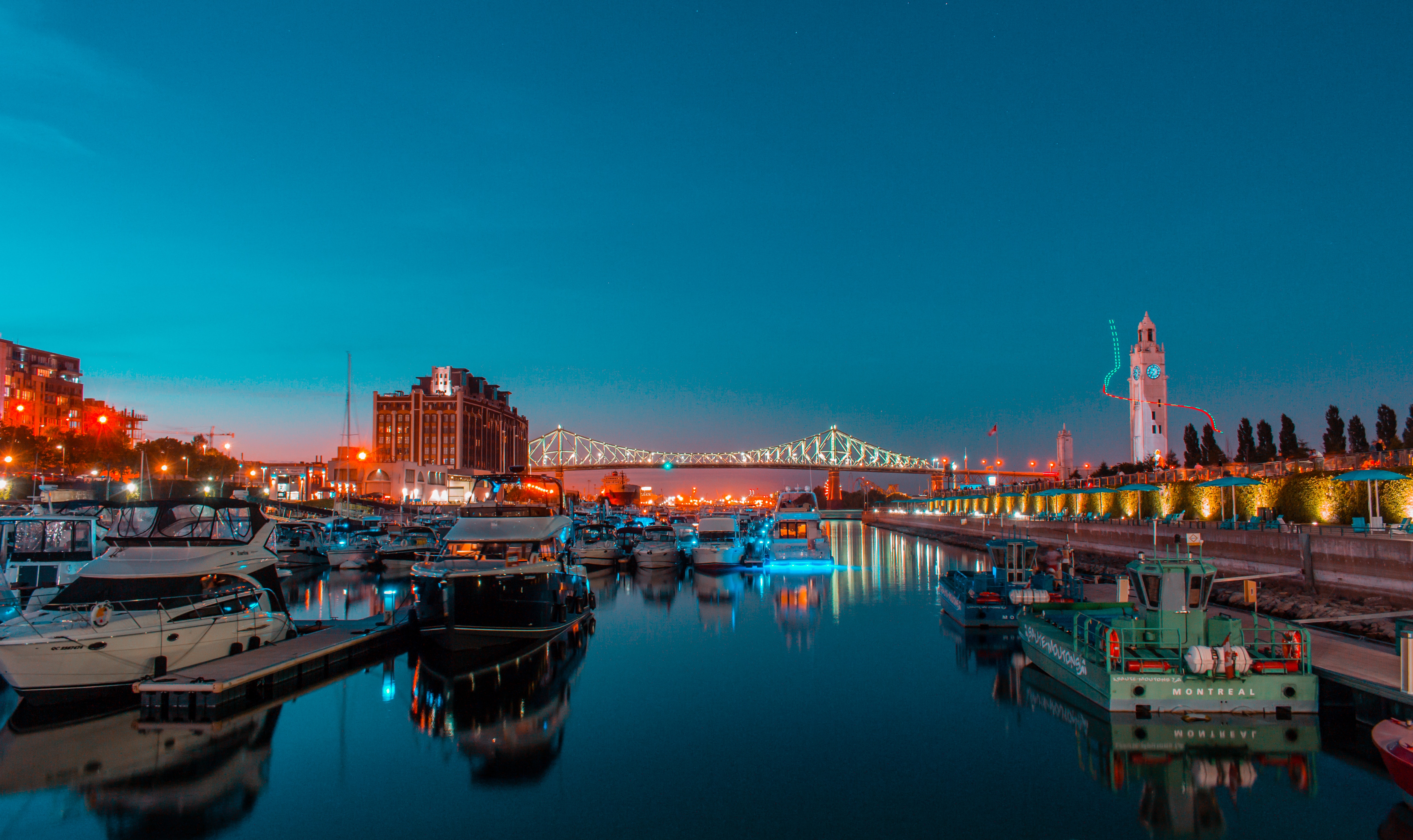
About Montréal, Québec
Canada's most diverse metropolis, Montréal, is an island city that favors style and elegance over order or even prosperity, a city where past and present intrude on each other daily. In some ways it resembles Vienna—well past its peak of power and glory, perhaps, yet still vibrant and grand.But don't get the wrong idea. Montréal has always had a bit of an edge. During Prohibition, thirsty Americans headed north to the city on the St. Lawrence for booze, music, and a good time, and people still come for the same things. Summer festivals celebrate everything from comedy and French music and culture to beer and fireworks, and, of course, jazz. And on those rare weeks when there isn't a planned event, the party continues. Clubs and sidewalk cafés are abuzz from late afternoon to the early hours of the morning. And Montréal is a city that knows how to mix it up even when it's 20 below zero. Rue St-Denis is almost as lively on a Saturday night in January as it is in July, and the festival Montréal en Lumière, or Montréal Highlights, enlivens the dreary days of February with concerts, balls, and fine food.Montréal takes its name from Parc du Mont-Royal, a stubby plug of tree-covered igneous rock that rises 764 feet above the surrounding cityscape. Although its height is unimpressive, "the Mountain" forms one of Canada's finest urban parks, and views from the Chalet du Mont-Royal atop the hill provide an excellent orientation to the city's layout and major landmarks.Old Montréal is home to museums, the municipal government, and the magnificent Basilique Notre-Dame-de-Montréal within its network of narrow, cobblestone streets. Although Montréal's centre-ville, or Downtown, bustles like many other major cities on the surface, it's active below street level as well, in the so-called Underground City–-the underground levels of shopping malls and food courts connected by pedestrian tunnels and the city's subway system, or métro. Residential Plateau Mont-Royal and trendy neighborhoods are abuzz with restaurants, nightclubs, art galleries, and cafés. The greener areas of town are composed of the Parc du Mont-Royal and the Jardin Botanique.
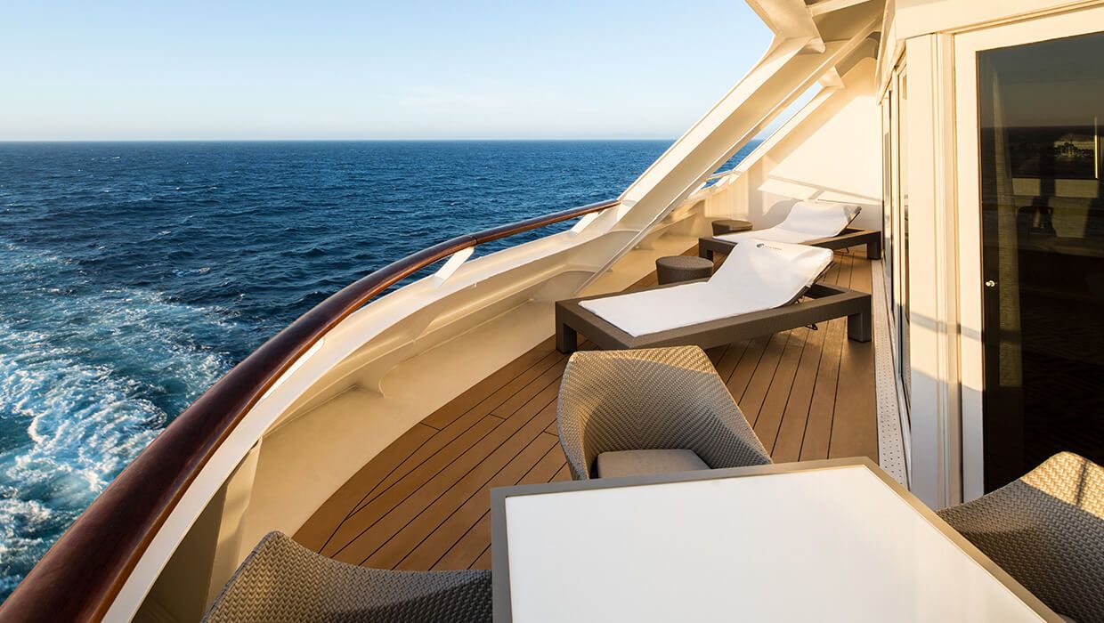
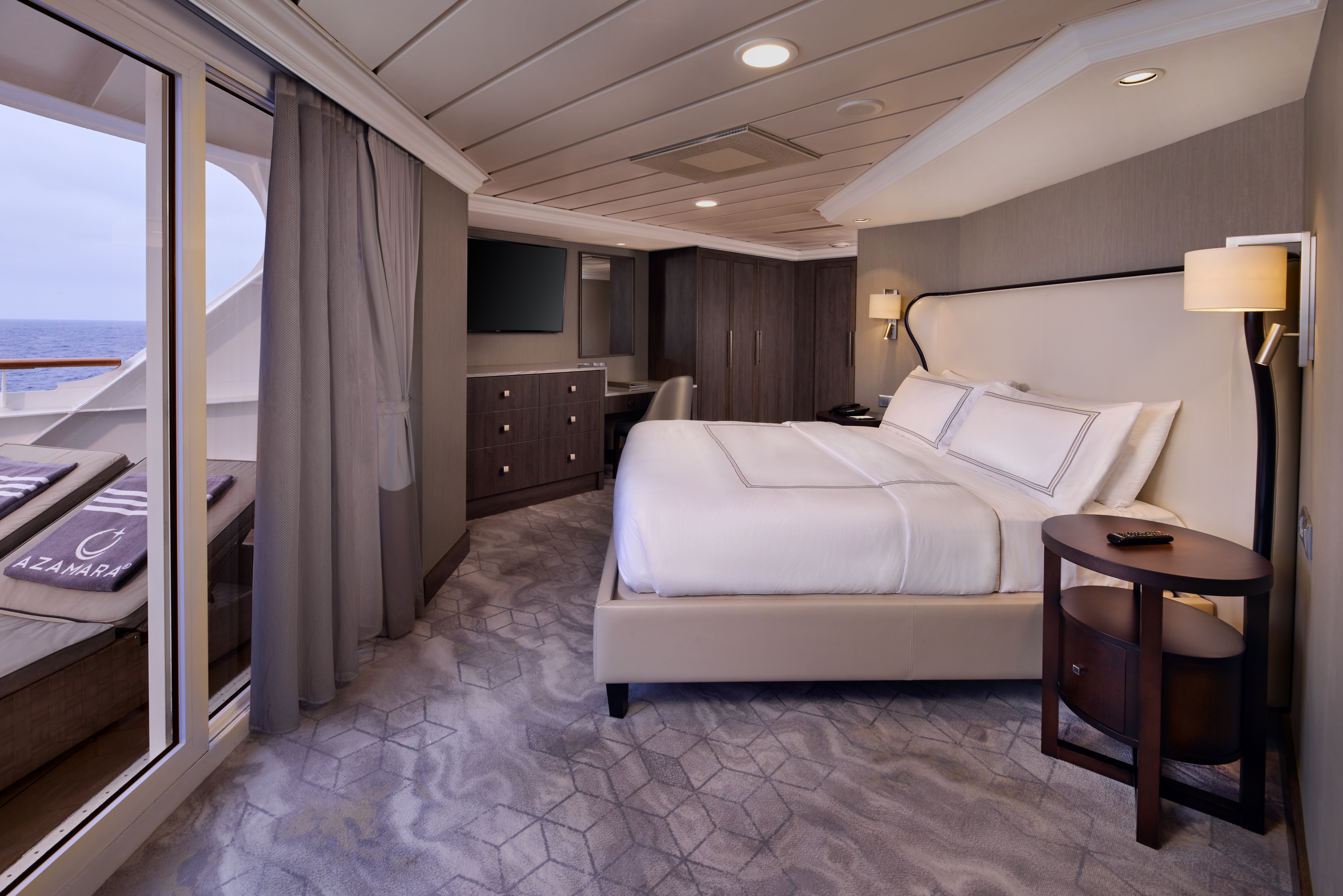
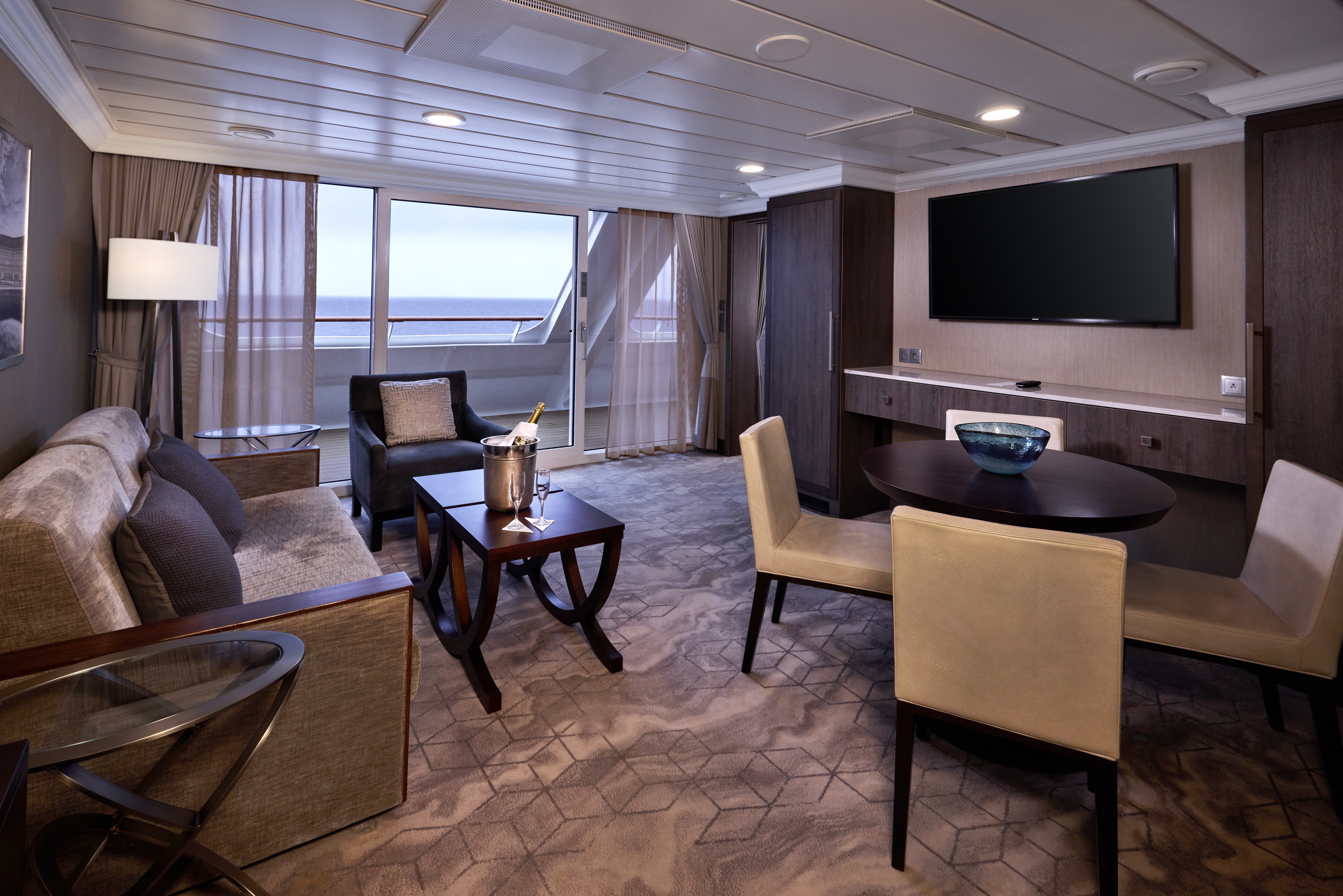
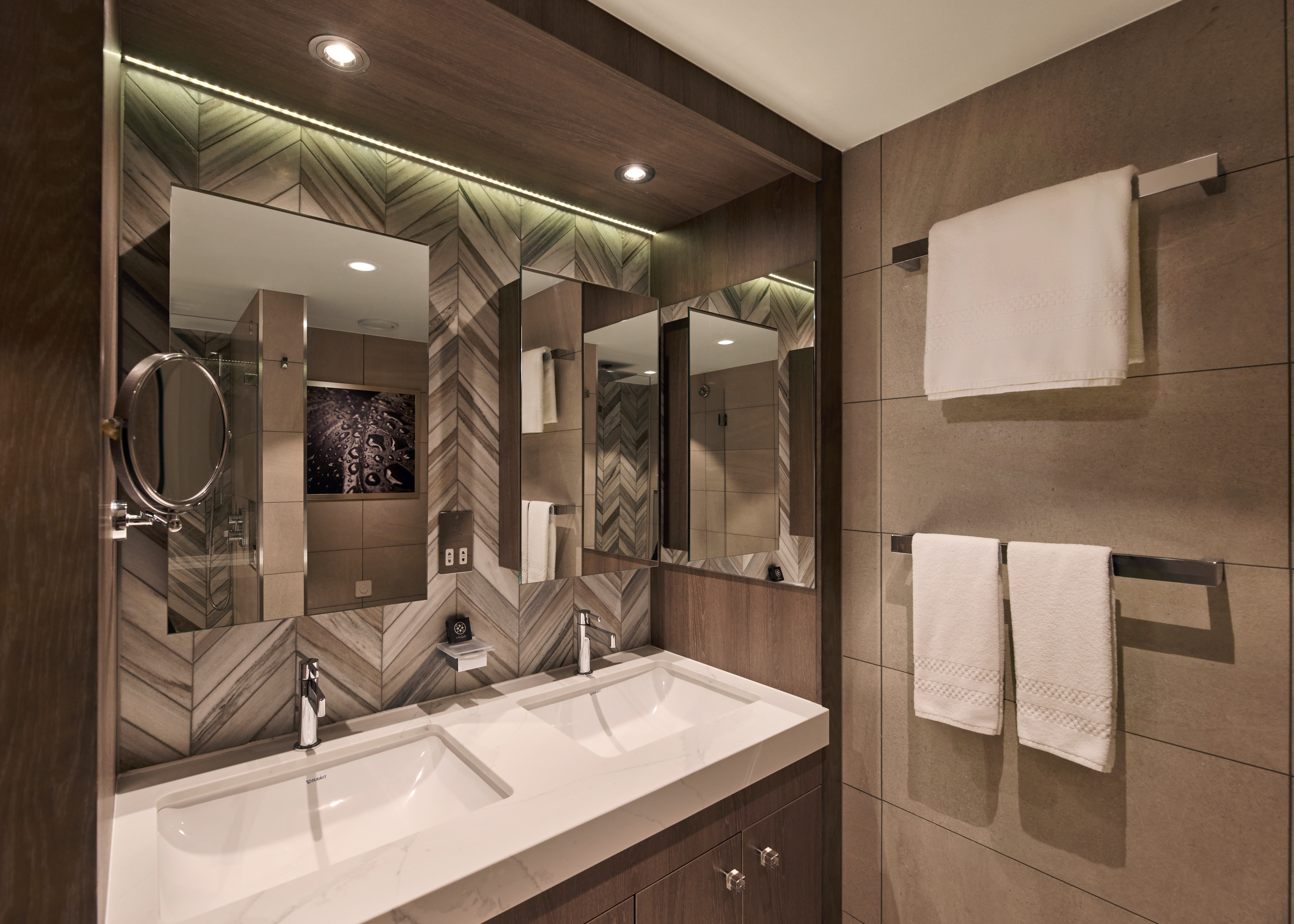
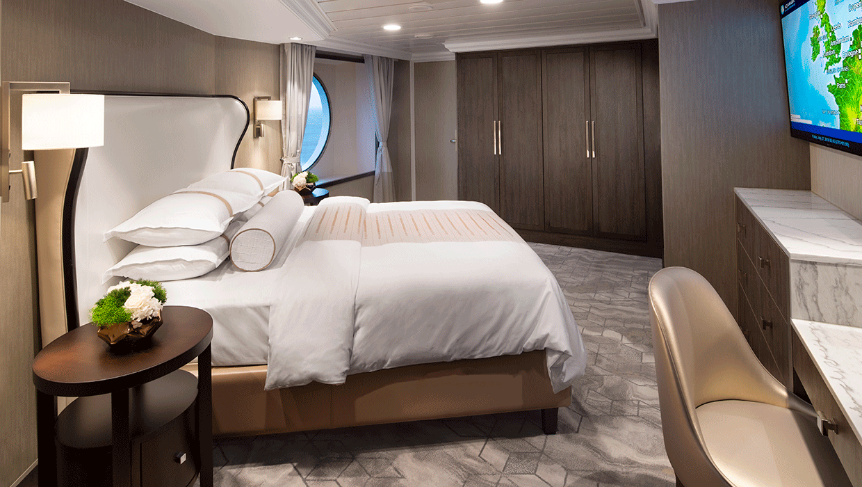
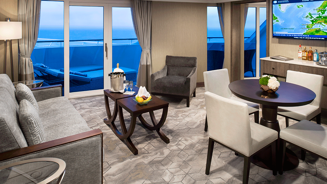
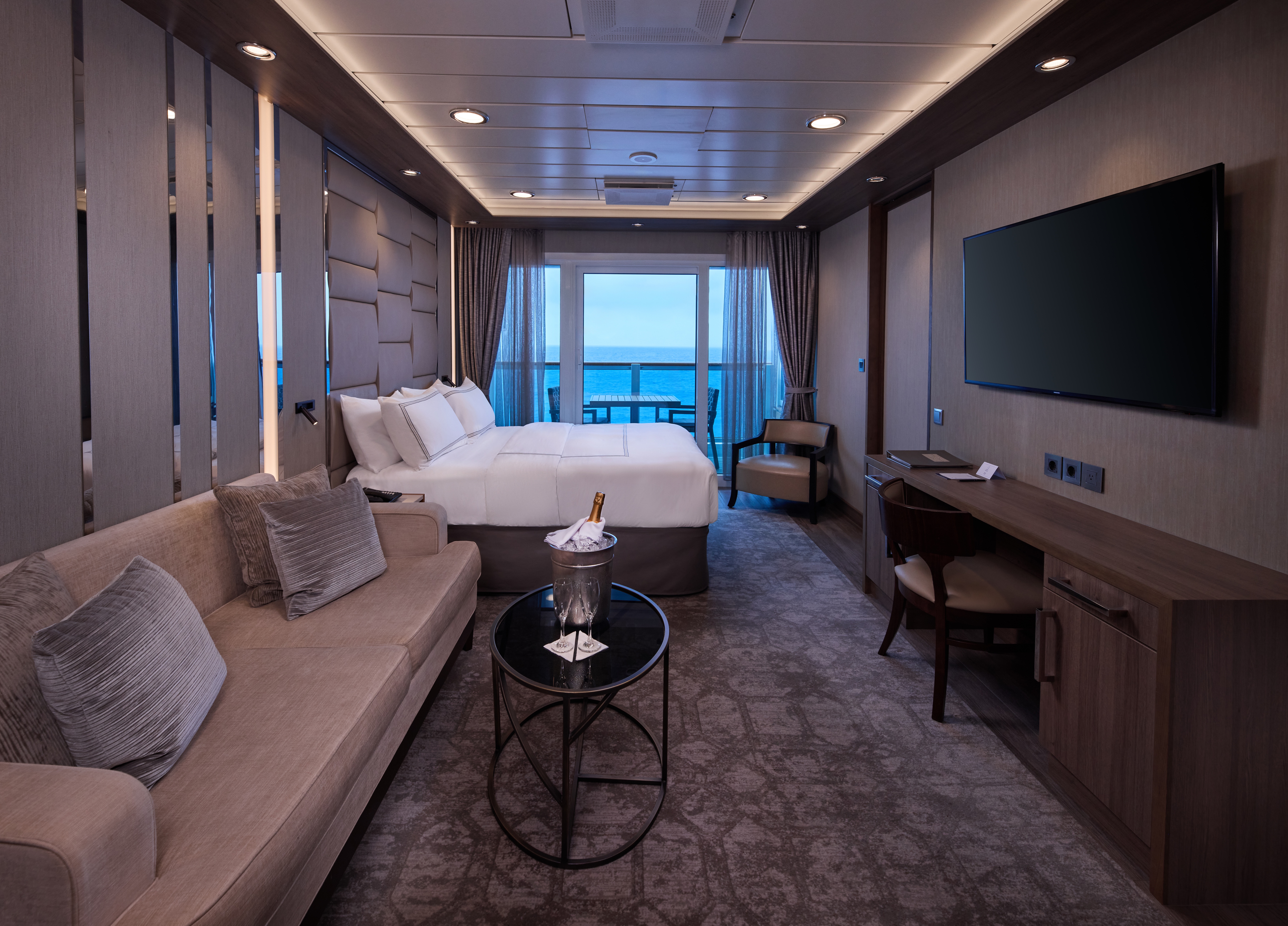
A signature expression of Azamara Cruises’ refined luxury, the World Owner’s Suite features a spacious layout, a separate bedroom, and a large private veranda. Thoughtfully designed for guests who value privacy, comfort, and elevated living.
Suite Features
- Spacious living room with a separate master bedroom
- Master bedroom with one queen size bed and a flat-screen television
- Flat-screen television in living room
- Marble master bathroom with shower. Journey, Onward, and Quest suites feature a tub.
- Dressing room with vanity and ample closet space
- Floor-to-ceiling sliding glass doors in living room and master bedroom
- Mini-bar
- Thermostat-controlled air conditioner
- Direct-dial telephone with voice mail
- Writing desk
- In-room safe
- Hand-held hair dryer
- Stateroom: 560 sq. ft. (52 sq. m.) Veranda: 233 sq. ft. (21.7 sq. m.)
Included Amenities
- Ultimate Beverage Package
- Unlimited Standard Starlink Wi-Fi
- Unlimited Wash and Press
- Dedicated butler and concierge service
- Full in-suite dining and daily evening hors d’oeuvres
- Complimentary Specialty Dining and exclusive breakfast at Aqualina
- In-room premium spirits and champagne
- Thalassotherapy Pool access
- Personalized assistance planning spa appointments and shore excursions
- Priority check-in
- Luxurious cotton bed linens with duvet
- Terry bathrobes
- 24-hour room service
- Tote bag
- Use of umbrella
- Shoeshine service
- Turndown treats
- Afternoon In-Suite Tea Service

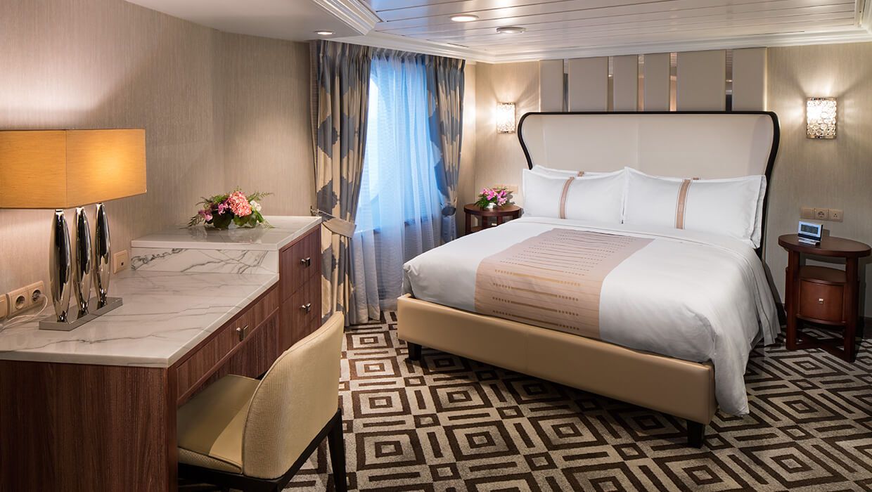
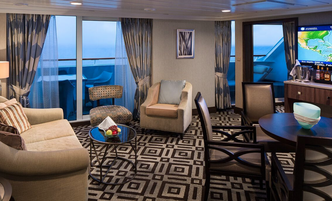
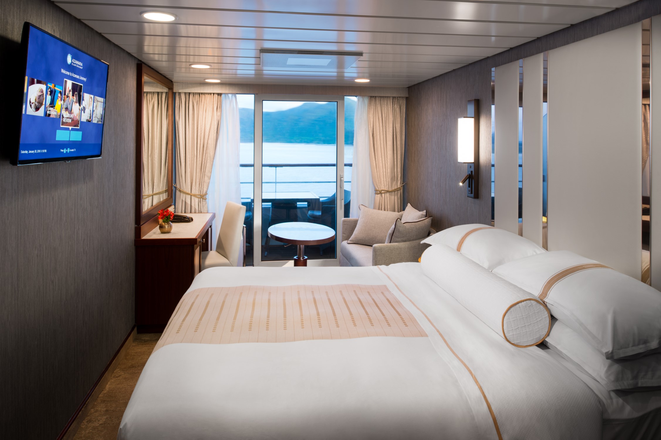
The Ocean Suite offers generous space to relax, with a separate living area, a dedicated bedroom, and a private veranda. An inviting retreat that balances comfort, functionality, and classic suite-style living.
Suite Features
- Spacious living room with a separate master bedroom
- Master bedroom with one queen size bed with a flat-screen television
- Flat-screen television in living room
- Marble master bathroom with shower. Journey and Quest suites feature a tub.
- Dressing room with vanity and ample closet space
- Floor-to-ceiling sliding glass doors in living room and master bedroom
- Mini-bar
- Thermostat-controlled air conditioner
- Direct-dial telephone with voice mail
- Writing desk
- In-room safe
- Hand-held hair dryer
- Stateroom: 440–501 sq. ft. (40.9-46.5 sq. m.) Veranda: 233 sq. ft. (21.7 sq. m.)
Included Amenities
- Ultimate Beverage Package
- Unlimited Standard Starlink Wi-Fi
- Unlimited Wash and Press
- Dedicated butler and concierge service
- Full in-suite dining and daily evening hors d’oeuvres
- Complimentary Specialty Dining and exclusive breakfast at Aqualina
- In-room premium spirits and champagne
- Thalassotherapy Pool access
- Personalized assistance planning spa appointments and shore excursions
- Priority check-in
- Luxurious cotton bed linens with duvet
- Terry bathrobes
- 24-hour room service
- Tote bag
- Use of umbrella
- Shoeshine service
- Turndown treats
- Afternoon In-Suite Tea Service
Designed for relaxation and renewal, the Spa Suite features a spacious layout with spa-inspired touches, including a glass-enclosed soaking tub and convenient access to the spa. A calming retreat ideal for wellness-focused travelers.
Suite Features
- Two lower beds convertible to one queen size bed
- Spacious glass-enclosed bathtub
- Separate rain shower
- Comfortable sitting area
- Flat-screen television in sitting area
- Floor-to-ceiling sliding glass doors
- Veranda
- Mini-bar
- Thermostat-controlled air conditioner
- Direct-dial telephone with voice mail
- Writing desk
- In-room safe
- Hand-held hair dryer
- Stateroom: 414 sq. ft. (38.5 sq. m.) Veranda: 40 sq. ft. (3.7 sq. m.)
Included Amenities
- Ultimate Beverage Package
- Unlimited Standard Starlink Wi-Fi
- Unlimited Wash and Press
- Dedicated butler and concierge service
- Full in-suite dining and daily evening hors d’oeuvres
- Complimentary Specialty Dining and exclusive breakfast at Aqualina
- In-room premium spirits and champagne
- Thalassotherapy Pool access
- Personalized assistance planning spa appointments and shore excursions
- Priority check-in
- Luxurious cotton bed linens with duvet
- Terry bathrobes
- 24-hour room service
- Tote bag
- Use of umbrella
- Shoeshine service
- Turndown treats
- Afternoon In-Suite Tea Service

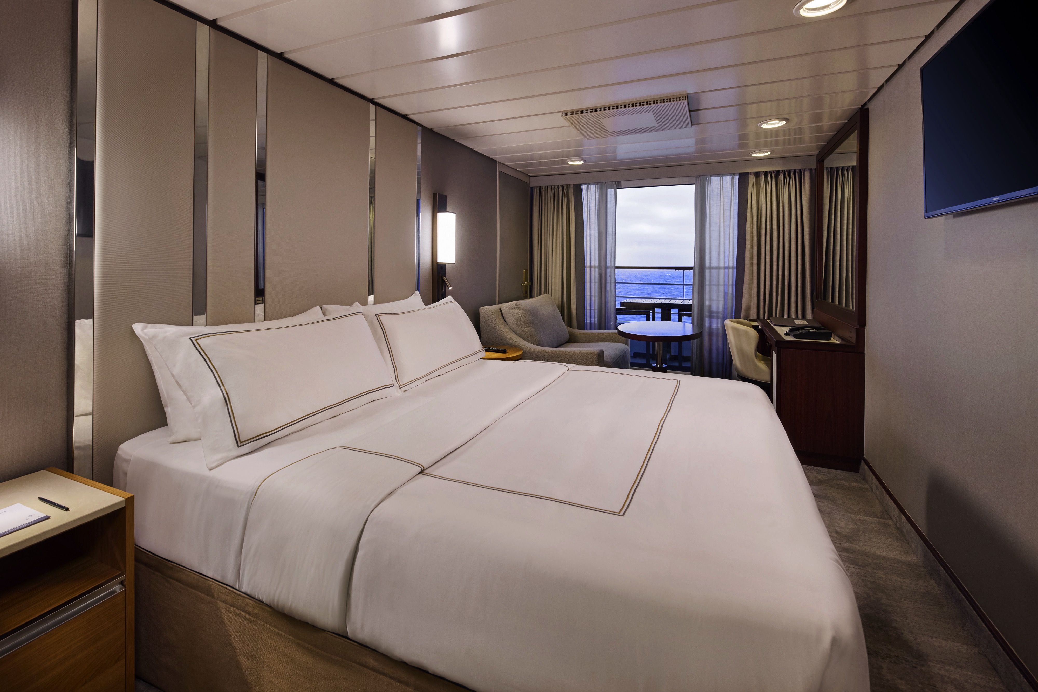
The Continent Suite offers a comfortable and well-appointed space with a private veranda, a welcoming seating area, and a generous bathroom. An inviting option for guests seeking suite-style accommodations with essential comforts.
Suite Features
- Two lower beds convertible to one queen size bed
- Spacious and comfortable seating area
- Flat-screen television in sitting area
- Roomy bathroom with shower. Some also feature a tub.
- Floor-to-ceiling sliding glass doors
- Veranda
- Mini-bar
- Thermostat-controlled air conditioner
- Direct-dial telephone with voice mail
- Writing desk
- In-room safe
- Hand-held hair dryer
- Stateroom: 266 sq. ft. (24.7 sq. m.) Veranda: 60 sq. ft. (5.6 sq. m.)
Included Amenities
- Unlimited Basic Starlink Wi-Fi
- 2 laundry bags (wash and press) per stateroom, per 7 nights
- Dedicated butler and concierge service
- Full in-suite dining and daily evening hors d’oeuvres
- Complimentary Specialty Dining and exclusive breakfast at Aqualina
- In-room premium spirits and champagne
- Thalassotherapy Pool access
- Personalized assistance planning spa appointments and shore excursions
- Priority check-in
- Luxurious cotton bed linens with duvet
- Terry bathrobes
- 24-hour room service
- Tote bag
- Use of umbrella
- Shoeshine-service
- Turndown treats
- Afternoon In-Suite Tea Service

The suite offers a comfortable and well-appointed space with a private veranda, a welcoming seating area, and a generous bathroom. An inviting option for guests seeking suite-style accommodations with essential comforts.


Enjoy open-air living with sweeping ocean and destination views, plus added perks designed to elevate your onboard experience. It’s everything you love about a Veranda Stateroom, with a little extra—at exceptional value.
Stateroom Features
- Veranda
- Two lower beds convertible to one Queen size bed
- Sitting area with flat-screen TV
- Mini-bar
- Thermostat-controlled air conditioner
- Direct-dial telephone with voice mail
- Writing desk
- In-room safe
- Hand-held hairdryer
- USB ports under bedside reading lamps
- Stateroom: 175 sq. ft. (16.3 sq. m.) | Veranda: 46–64 sq. ft. (4.3-6 sq. m.)
Included Stateroom Amenities
- Complimentary AzAmazing Evenings® event (on most voyages)
- Gratuities
- Luxurious cotton bed linens with duvet
- Terry bathrobes and slippers
- Select standard spirits, international beers and wine
- 24-hour room service
- Bottled water, soft drinks, specialty coffees and teas
- Self-service laundry
- Tote bag
- Shuttle service to and from port communities, wher
- Use of umbrella
- Concierge services for personal guidance and reservations
- Shoe shine-service
- Turndown treats
- Daily news bulletin
- Complimentary Internet (120 minutes or 25% off the unlimited internet package) per guest
- One free bag of laundry service per stateroom, every seven days
- One night of complimentary specialty dining for two, every seven days
- Priority embarkation and debarkation
- Complimentary in-room spirits
Enjoy open-air living with sweeping ocean and destination views, plus added perks designed to elevate your onboard experience. It’s everything you love about a Veranda Stateroom, with a little extra—at exceptional value.
Step outside to your private veranda and take in fresh sea breezes and ever-changing views. Thoughtful design, polished finishes, and attentive service create a relaxing retreat between immersive days ashore.
Stateroom Features
- Veranda
- Two lower beds convertible to one Queen size bed
- Sitting area with flat-screen TV
- Refrigerator with mini-bar
- Thermostat-controlled air conditioner
- Direct-dial telephone with voicemail
- Writing desk
- In-room safe
- Hand-held hairdryer
- USB ports under bedside reading lamps
- Stateroom: 175 sq. ft. (16.3 sq. m.) | Veranda: 40 sq. ft. (3.7 sq. m.)
Included Stateroom Amenities
- Complimentary AzAmazing Evenings® event (on most voyages)
- Luxurious cotton bed linens with duvet
- Gratuities
- Terry bathrobes
- Select standard spirits, international beers and wine
- 24-hour room service
- Self-service laundry
- Tote bag
- Shuttle service to and from port communities, where available
- Use of umbrella
- Concierge services for personal guidance and reserervations
- Shoe shine-service
- Turndown treats
- Daily news bulletin
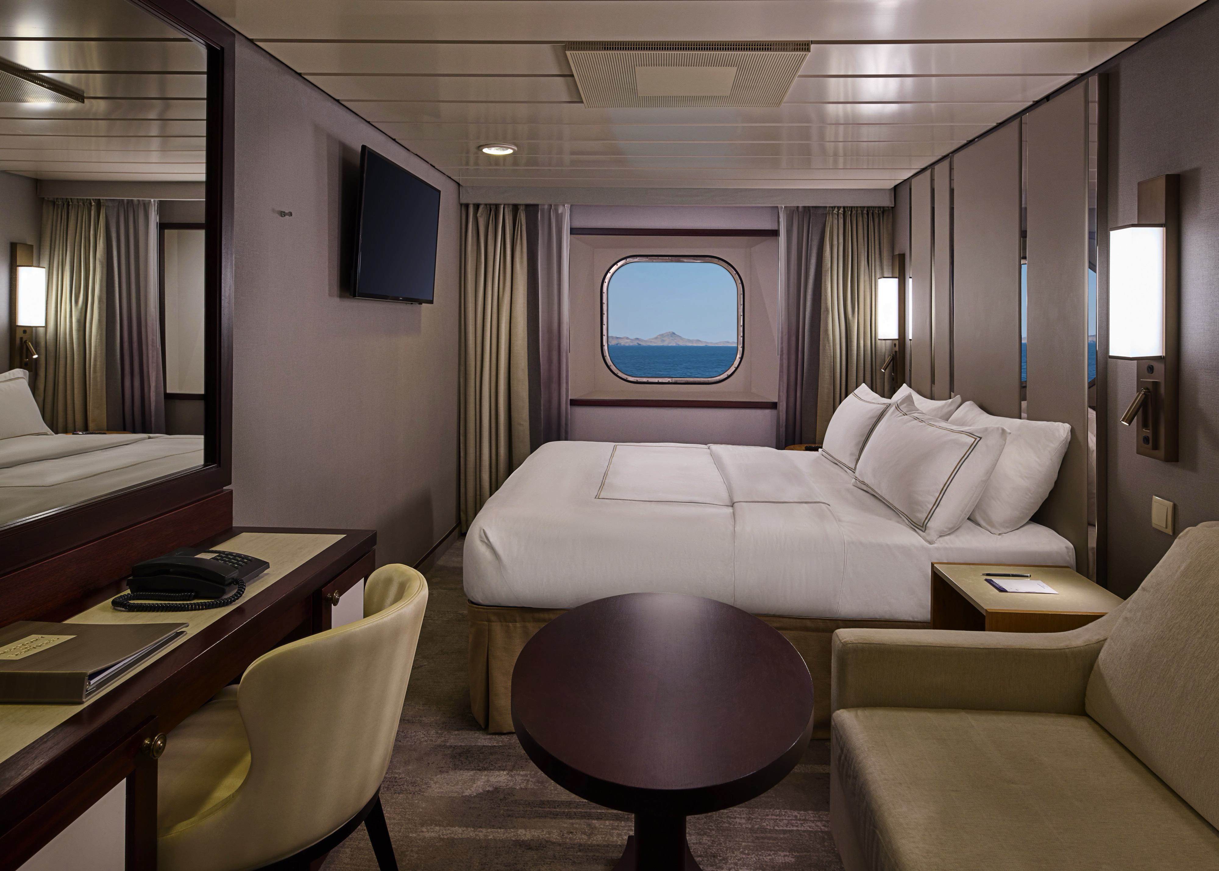
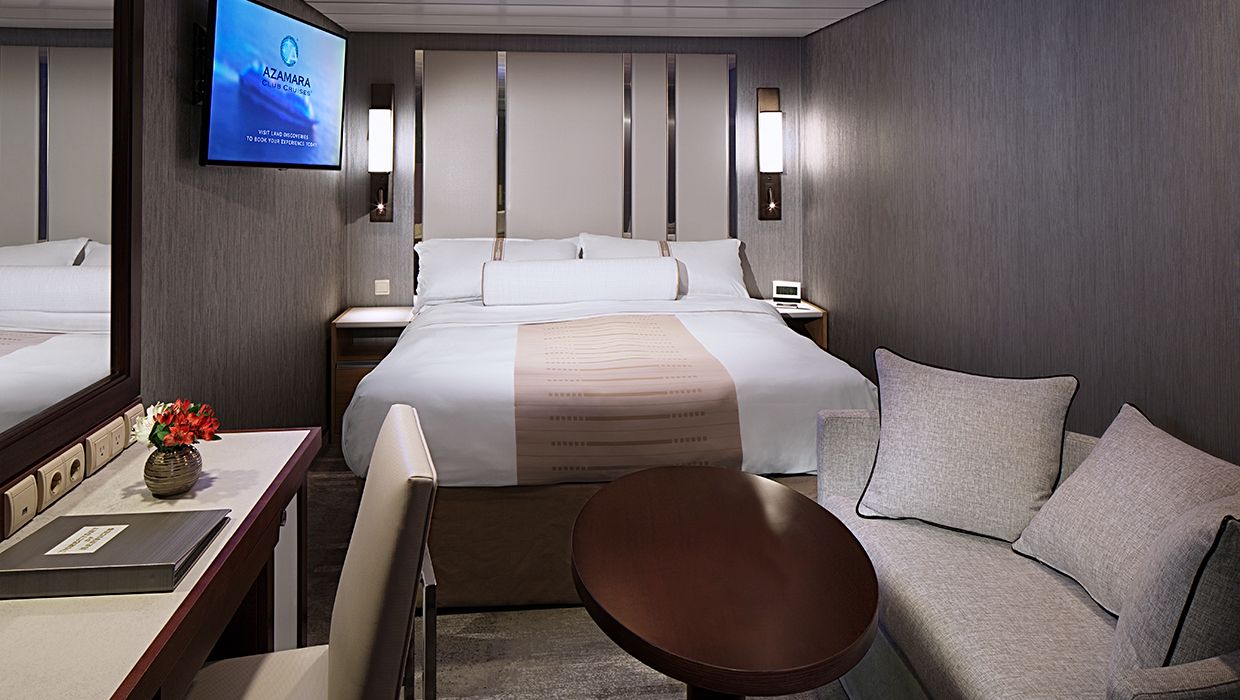
Wake up to natural light and picturesque ocean views from your window. Featuring contemporary design and well-appointed comforts, these staterooms offer a serene and stylish place to unwind at sea.
Stateroom Features
- Two lower beds convertible to one Queen size bed
- Some staterooms feature sofa bed
- Flat-screen TV
- Refrigerator with mini-bar
- Thermostat-controlled air conditioner
- Direct-dial telephone with voicemail
- Writing desk
- In-room safe
- Hand-held hairdryer
- USB ports under bedside reading lamps
- 143 sq. ft. (13.3 sq m)
Included Stateroom Amenities
- Complimentary AzAmazing Evenings® event (on most voyages)
- Gratuities
- Luxurious cotton bed linens with duvet
- Terry bathrobes and slippers
- Select standard spirits, international beers and wine
- 24-hour room service
- Bottled water, soft drinks, specialty coffees and teas
- Self-service laundry
- Tote bag
- Shuttle service to and from port communities, wher
- Use of umbrella
- Concierge services for personal guidance and reservations
- Shoe shine-service
- Turndown treats
Wake up to natural light and picturesque ocean views from your window. Featuring contemporary design and well-appointed comforts, these staterooms offer a serene and stylish place to unwind at sea.
A quiet, comfortable retreat designed for restful nights and relaxing moments between adventures. With refined décor, plush amenities, and personalized service, it’s boutique-hotel comfort at sea.
Stateroom Features
- Two lower beds convertible to one Queen size bed
- Flat-screen television
- Refrigerator with mini-bar
- Thermostat-controlled air conditioner
- Direct-dial telephone with voicemail
- Writing desk
- In-room safe
- Hand-held hairdryer
- USB ports under bedside reading lamps
- Stateroom: 158 sq. ft. (14.7 sq. m.)
Included Stateroom Amenities
- Complimentary AzAmazing Evenings® event (on most voyages)
- Gratuities
- Luxurious cotton bed linens with duvet
- Terry bathrobes and slippers
- Select standard spirits, international beers and wine
- 24-hour room service
- Bottled water, soft drinks, specialty coffees and teas
- Self-service laundry
- Tote bag
- Shuttle service to and from port communities, wher
- Use of umbrella
- Concierge services for personal guidance and reservations
- Shoe shine-service
- Turndown treats
- Daily news bulletin
A quiet, comfortable retreat designed for restful nights and relaxing moments between adventures. With refined décor, plush amenities, and personalized service, it’s boutique-hotel comfort at sea.
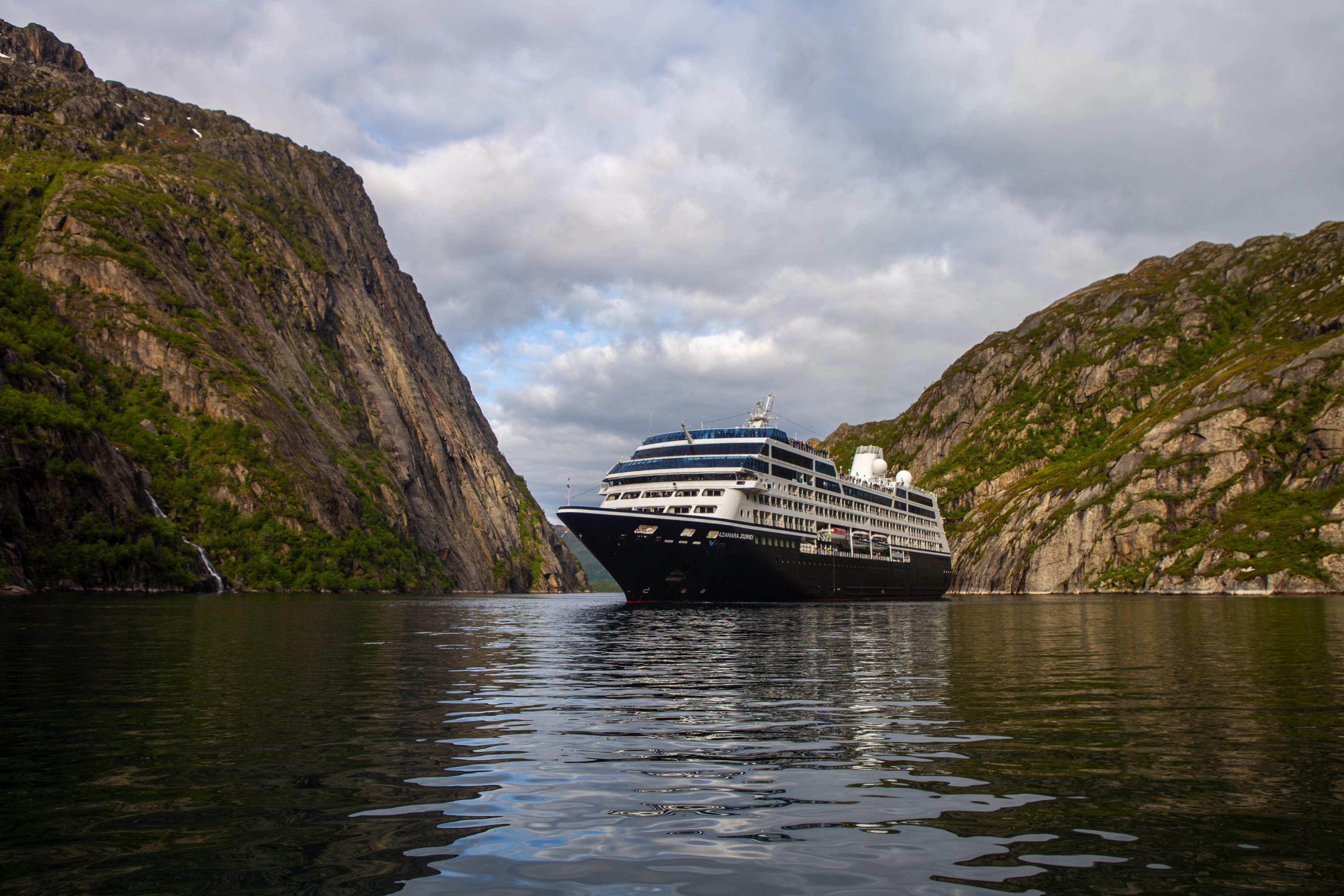
Azamara Journey
A luxurious boutique hotel at sea, the Azamara Journey is a mid-sized ship with a deck plan that’s intimate but never crowded, and offers everything modern cruisers are looking for—plus some unexpected extras.
Ship Facts
| Launch Year | 2000 | ||||||||||
| Refit Year | 2016 | ||||||||||
| Language | en-US | ||||||||||
| Gross Tonnage | 30277 | ||||||||||
| Length | 182 | ||||||||||
| Width | 25 | ||||||||||
| Currency | USD | ||||||||||
| Speed | 18 | ||||||||||
| Capacity | 690 | ||||||||||
| Crew Count | 408 | ||||||||||
| Deck Count | 8 | ||||||||||
| Cabin Count | 355 | ||||||||||
| Large Cabin Count | N/A | ||||||||||
| Wheelchair Cabin Count | 6 | ||||||||||
| Electrical Plugs |
|
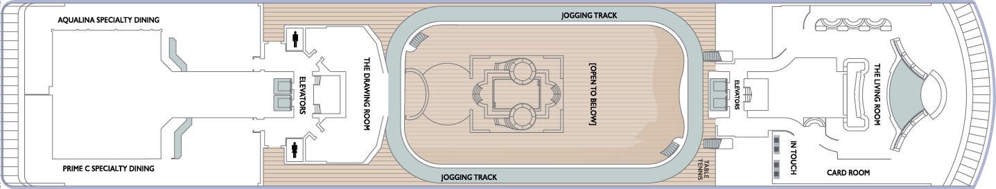
Deck 11
- Sun Deck
- Shuffle Board

Deck 10
- The Living Room
- Card Room
- In Touch
- Elevators
- Table Tennis
- Jogging Track
- The Drawing Room
- Prime C Speciality Dining
- Aqualina Speciality Dining
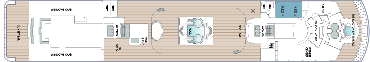
Deck 9
- The Sanctum Spa Terrace
- Salon
- The Sanctum Spa
- Fitness Center
- Pool
- Pool Bar
- Elevators
- Swirl & Top
- The Patio
- Windows Café
- Sunset Bar
- Spa Suites
Deck 8
- Veranda Plus Staterooms
- World Owner's Suite
- Continent Suite
- Interior Staterooms

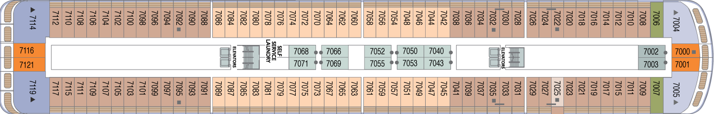
Deck 7
- Veranda Plus Staterooms
- World Owner's Suite
- Ocean Suite
- Veranda Staterooms
- Oceanview Staterooms
- Interior Staterooms
- Self Service Laundry
Deck 6
- Veranda Plus Staterooms
- Veranda Staterooms
- World Owner's Suite
- Continent Suite
- Ocean Suite
- Oceanview Staterooms
- Interior Staterooms

Deck 5
- Cabaret Lounge
- Elevators
- Shore Excursions
- Cruise Again
- The Den
- Photo Shop
- The Journey Shops
- Indulgences
- Mosaic Café
- Discoveries Bar
- Discoveries Restaurant

Deck 4
- Oceanview Staterooms
- Interior Staterooms
- Medical Facility
- Guest Relations
- Concierge

Azamara offers a choice of six distinctive dining options, including room service. Whether you’re a fan of haute cuisine or down-home cooking, expect the same delicious quality. Bon appétit! Buon appetito! ¡Buen provecho! No matter how you say it, you’re in for a real treat.
Pre-Cruise Specialty Dining Reservations
All guests can now book pre-cruise reservations for Prime C, Aqualina, or Chef’s Table—our most sought-after specialty dining experiences.
Priority Access
Pre-cruise dining reservations open 150 days before sailing for suite guests and Azamara Circle Discoverer-level and above. All other guests may begin booking 140 days prior.
Aqualina
At Aqualina, you’ll find some of Italy’s most authentic dishes. Pastas made from scratch, traditional recipes, and scrumptious vegetarian dishes that make sure there’s something for everyone. Plus our famous desserts: Sorrento lemon liqueur mousse, hazelnut chocolate soufflé and more.
Prime C
Your choice of steak, cooked to perfection. Herb-coated rack of lamb, duck confit and Chilean sea bass—all paired with savory sides. At Prime C, you’re in for more than delectable dining. Expect a great evening with stunning views and lush décor.
Discoveries Restaurant
Discover the world through dishes and flavors from the places we visit. Of course, you’ll also enjoy a wide variety of nightly selections such as filet mignon with black truffle sauce. Choose being seated at a table for two or as part of a larger group of fellow guests.
Windows Café
Our daily themed dinner often takes its inspiration from the region we’re visiting—Indian, Mexican, Spanish, Italian. We also create an extra live station made from local ingredients purchased in port: Greek salad made with local feta (Greece), pasta prepared with local mushrooms (Italy), fresh Mussels served with garlic bread (Netherlands).
The Patio And Swirl & Top
Casual “pool grill” by day. A sit-down al fresco dining experience by night. Taste your way around the world with exclusive personalized dishes using local flavors of the places we visit. Plus a self-serve frozen yogurt station—Swirl & Top. With a variety of flavors and your choice of toppings, it’s the perfect way to cool off.
Mosaic Café
Stylish and cozy, Mosaic offers your favorite coffee drinks exactly as you like them. Relax in a comfortable seat and enjoy. It’s the perfect spot to start or end your day, and it just might become your favorite place on the ship.
Room Service
The best time for room service? Whenever you say it is, 24-hours a day. Order from the full breakfast menu between 6:30 AM and 10:00 AM, and we’ll deliver at your appointed time. Lunch and dinner room service features a menu of hearty soups, fresh salads, gourmet sandwiches, pizzas and desserts.
Sit back and enjoy your evenings on a high note with our onboard entertainment. From local cultural shows to our playbill that features a variety of amazing performances to keep you entertained while onboard.
Bars, Lounges & Gathering Spots
A cozy nook to sip coffee. An intimate space to raise a glass and celebrate. A lively setting to catch the latest shows and international entertainment. Watch the world go by, drink in hand from any of Azamara’s bars, lounges, and gathering spaces.
White Night
Join Azamara officers and crew for our signature dinner and entertainment event hosted al fresco on the pool deck (weather permitting). With an array of delicious food and engaging entertainment, your White Night experience will almost certainly be one of the most memorable times from your cruise. And don’t forget to bring something white to wear for the evening.
Club Crooner
Step into a swanky nightclub as the great songs of the most magnificent artists come alive on stage. From classic crooners such as Frank Sinatra and Tony Bennett, to current songbirds such as Natalie Cole and Michael Bublé, there’s a song for every time and everyone. Enjoy a beverage, sit back, and be serenaded by the melodies of our lives with CLUB CROONER!
The Living Room
The idea of the Living Room is just that. To “live in” and to enjoy time with friends and fellow guests! Much of the room is furnished as a living room, with clusters of large comfortable chairs and sofas....
Discoveries Lounge
This congenial bar is a favorite gathering place for great conversations and delicious drinks. Bar service includes a full selection of fine wines, mixed drinks, and premium spirits…plus the entertaining banter of Azamara’s friendly bartenders.
Cabaret Lounge
Enjoy live performances of professional full-stage musical revues, classical soloists, bands and other entertainment in a cabaret nightclub with a full bar and cozy tables.
Sunset Bar
Adjacent to Windows Café, the Sunset Bar is a welcoming outdoor patio with covered and open-air seating, and a bar. It's the perfect place for dining alfresco, enjoying a refreshing drink, taking in the sights of your favourite port, or simply watching the world sail by.
Mosaic Cafe & Mosaic Cafe @ Night
Our onboard coffee corner may very well become your favorite nook on the ship. With elegant and comfortable furniture, it's bound to be one of the the most stylish places, too. Find all your favorite coffee drinks crafted just the way you like. Slip right into a comfortable seat and sip for a while—you never know who'll walk by.
Pool Bar
Our Pool Bar serves refreshments while enjoying the Pool during the day, and cocktails of your choice in the evening.
The Wine Cellar
You’ll be hard-pressed to find such a collection of limited production, small label and rare vintage wines anywhere on the high seas! And with vintages from France to California, and Argentina to South Africa, you’re sure to find a wine to suit your palate and your journey. Our knowledgeable sommeliers can help you pick the perfect wines for your evening meal.
Performances
And the Beat Goes On
Join your Signature Singers and Dancers as they commemorate the greatest hits of all time in And the Beat Goes On. The night celebrates a wide variety of musical genres while exploring the influence of mainstream media in honoring the iconic cultural trends throughout the years. Featuring music from The Beatles, Earth Wind and Fire, Journey, Madonna, Ricky Martin, Katy Perry and much more. We will be sure to have you singing and dancing all night long in AND THE BEAT GOES ON!
Six Strings
The guitars are tuned, the amps are cranked up and the microphones are hot as Azamara prepares you for a night of energetic dancing, powerful vocals and iconic guitar riffs in Six Strings. The evening guarantees a Good Time with ultimate nostalgia as our Signature Singers and Dancers celebrate the most renowned classic rock artists such as Aerosmith, The Beatles, Pat Benatar, The Rolling Stones, Queen and more. Don’t miss SIX STRINGS!
Oh, What A Night
Get ready to be transported to the world’s most beloved travel destinations in one exhilarating night. As we explore all four seasons in a new city, travel along with our dynamic Signature Singers & Dancers as they sing and dance their way through an eclectic mix of music from around the world. Come and experience Oh, What A Night!
The Pool
While spending daytime sun-drenched and relaxed by the pool, don’t think of missing Azamara’s famous White Night party held at least once on every cruise (weather permitting). Colourful décor and linen-draped tables, a fabulous buffet feast, and boutique wines on the house make this an event like no other. Not to forget the fun and fast-paced show our entertainment team puts on.
The Ship Shop
Pick up sundries, casual wear and swim fashions, sunglasses, accessories, music and shipboard keepsakes. This is a great place for small gifts to take back home.
Indulgences
Aptly named, Indulgences will satisfy your desires for the finer things in life. If you are looking for designer jewellery, it's the perfect place to window shop or to find that extra special purchase.
Photo Shop
Our photographers capture both fun and professional photos throughout the voyage, whether it is your portrait, or photos of the destinations you visit. You can also find an assortment of supplies for your own photographic endeavours.