
Vikings & Bon Vivants
Vikings & Bon Vivants
Cruise overview
WHY BOOK WITH US?
- ✔ The Deluxe Cruises’ team has extensive experience in ultra-luxury cruising.
- ✔ Call now to speak to our helpful and experienced Cruise Concierge team.
- ✔ Enjoy our Unique Deluxe Cruises Bonus for substantial savings.
- ✔ Our team will tailor your holiday to your exacting requirements.
- ✔ As agents, we work under the protection of each cruise lines ABTA / ATOL licences
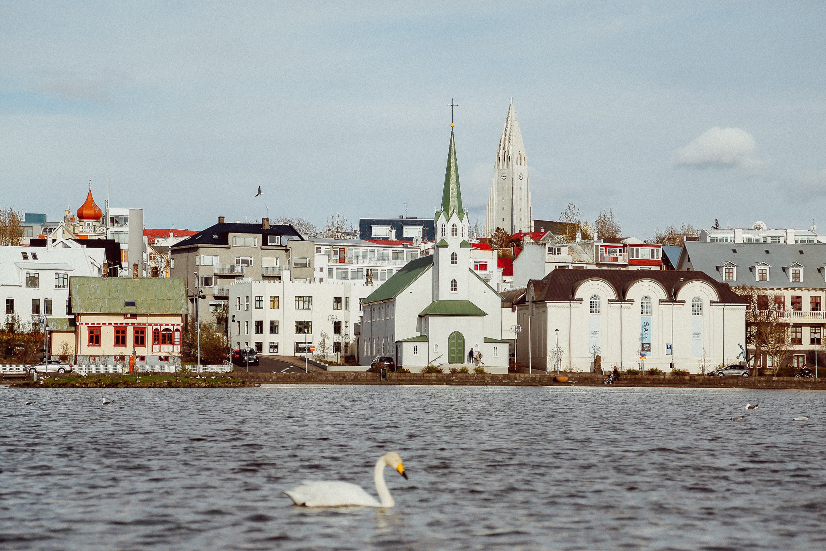
About Reykjavík
Sprawling Reykjavík, the nation's nerve center and government seat, is home to half the island's population. On a bay overlooked by proud Mt. Esja (pronounced eh-shyuh), with its ever-changing hues, Reykjavík presents a colorful sight, its concrete houses painted in light colors and topped by vibrant red, blue, and green roofs. In contrast to the almost treeless countryside, Reykjavík has many tall, native birches, rowans, and willows, as well as imported aspen, pines, and spruces.Reykjavík's name comes from the Icelandic words for smoke, reykur, and bay, vík. In AD 874, Norseman Ingólfur Arnarson saw Iceland rising out of the misty sea and came ashore at a bay eerily shrouded with plumes of steam from nearby hot springs. Today most of the houses in Reykjavík are heated by near-boiling water from the hot springs. Natural heating avoids air pollution; there's no smoke around. You may notice, however, that the hot water brings a slight sulfur smell to the bathroom.Prices are easily on a par with other major European cities. A practical option is to purchase a Reykjavík City Card at the Tourist Information Center or at the Reykjavík Youth Hostel. This card permits unlimited bus usage and admission to any of the city's seven pools, the Family Park and Zoo, and city museums. The cards are valid for one (ISK 3,300), two (ISK 4,400), or three days (ISK 4,900), and they pay for themselves after three or four uses a day. Even lacking the City Card, paying admission (ISK 500, or ISK 250 for seniors and people with disabilities) to one of the city art museums (Hafnarhús, Kjarvalsstaðir, or Ásmundarsafn) gets you free same-day admission to the other two.


About Grundarfjørdur

About Isafjørdur
Two colossal terraces of sheer rock stand either side of this extraordinarily located town - which rides a jutting spit onto an immensity of black fjord water. Surprisingly, considering the remoteness of its location and its compact size, Isafjordur is a modern and lively place to visit, offering a great choice of cafes and delicious restaurants – which are well stocked to impress visitors. The town is a perfectly located base for adventures amongst Iceland's fantastic wilderness - with skiing, hiking and water-sports popular pursuits among visitors.

About Narsaq

About Paamiut (Fredrikshaab)

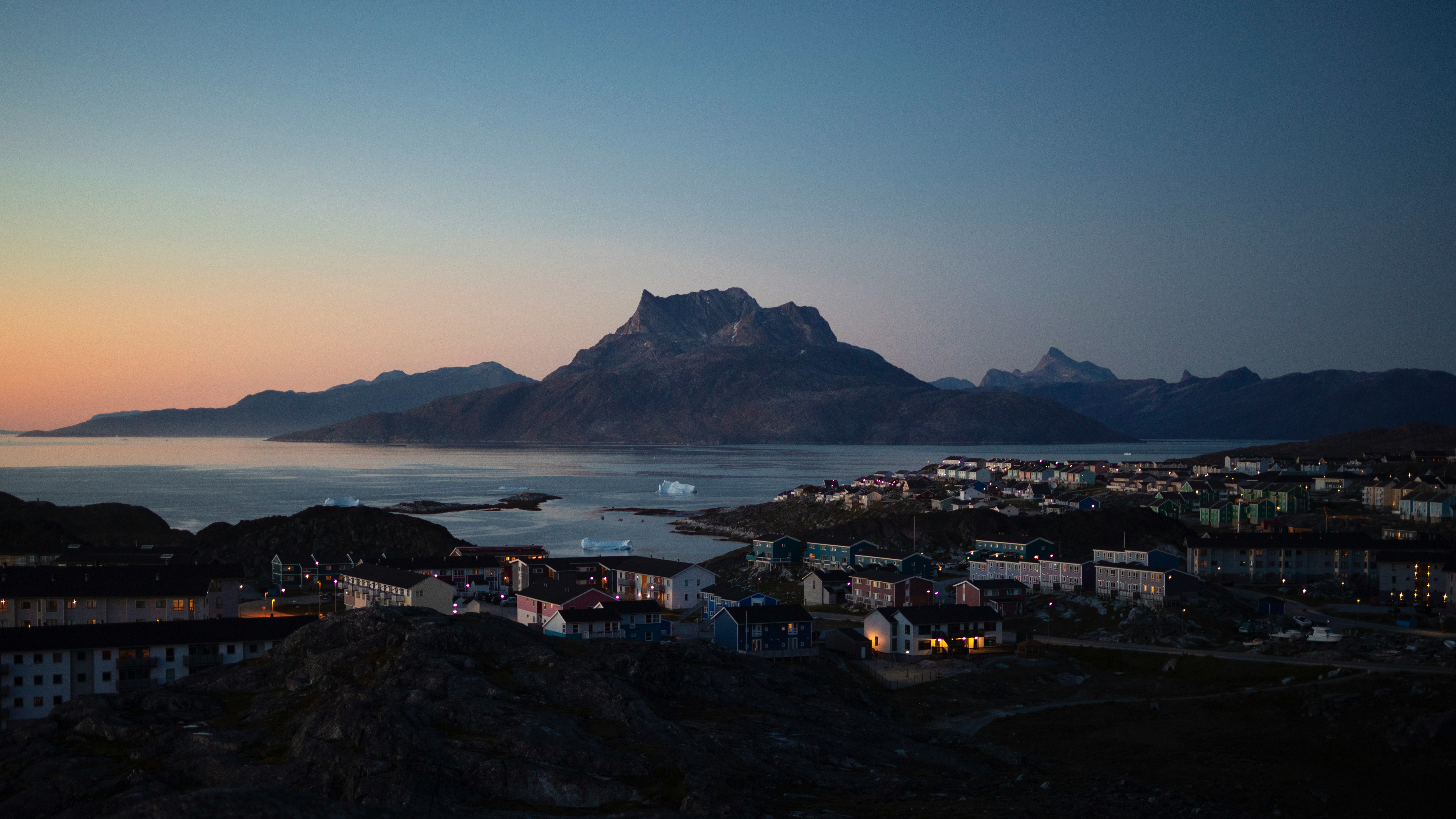
About Nuuk (Godthaab)
Nuuk, meaning “the cape”, was Greenland’s first town (1728). Started as a fort and later mission and trading post some 240 kilometers south of the Arctic Circle, it is the current capital. Almost 30% of Greenland’s population lives in the town. Not only does Nuuk have great natural beauty in its vicinity, but there are Inuit ruins, Hans Egede’s home, the parliament, and the Church of our Saviour as well. The Greenlandic National Museum has an outstanding collection of Greenlandic traditional dresses, as well as the famous Qilakitsoq mummies. The Katuaq Cultural Center’s building was inspired by the undulating Northern Lights and can house 10% of Nuuk’s inhabitants.

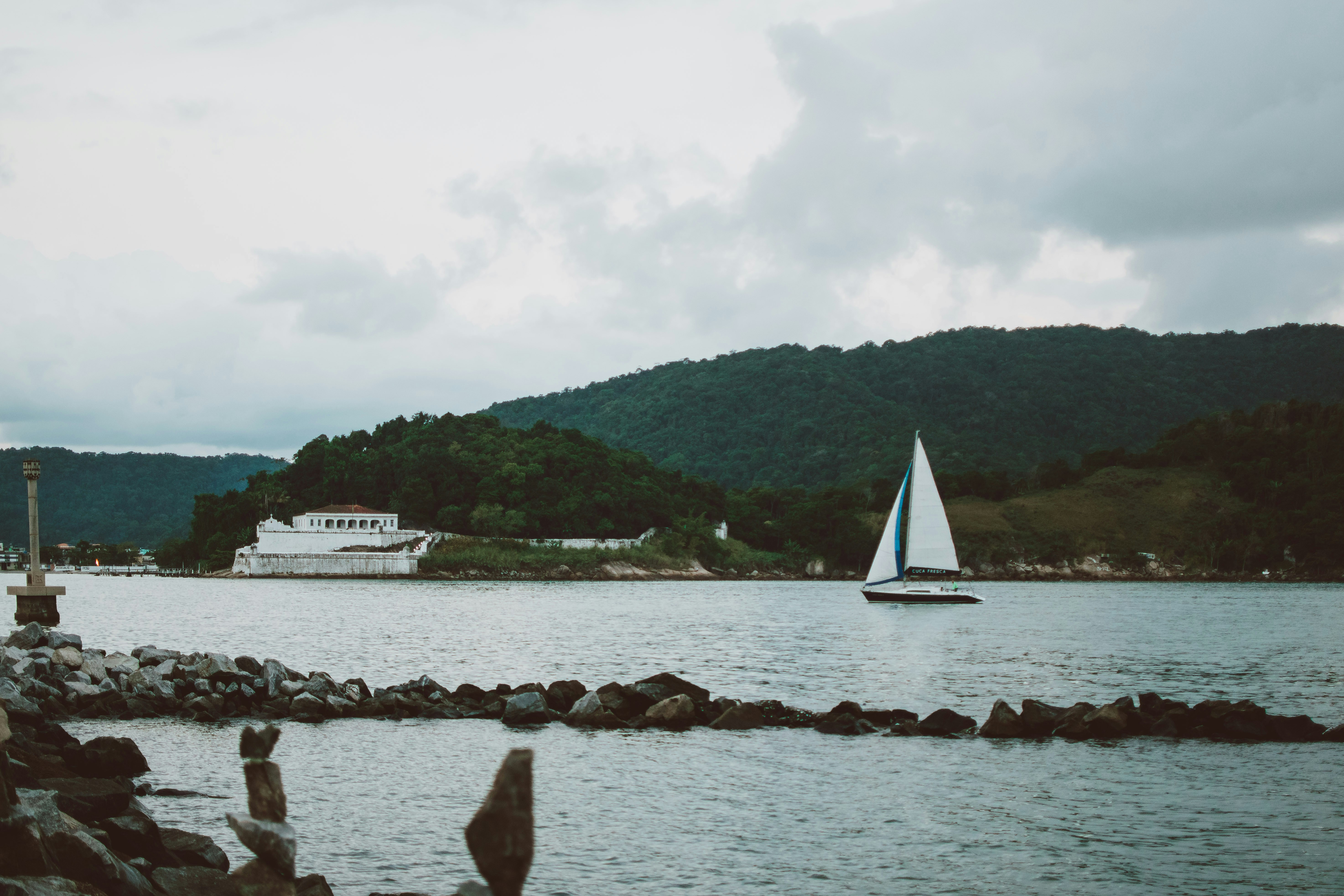
About Santos

About Corner Brook, Newfoundland and Labrador
Newfoundland's fourth-largest city, Corner Brook is the hub of the island's west coast. Hills fringe three sides of the city, which has dramatic views of the harbor and the Bay of Islands. The town is also home to a large paper mill and a branch of Memorial University. Captain James Cook, the British explorer, charted the coast in the 1760s, and a memorial to him overlooks the bay.The town enjoys more clearly defined seasons than most of the rest of the island, and in summer it has many pretty gardens. The nearby Humber River is the best-known salmon river in the province, and there are many kilometers of well-maintained walking trails in the community.


About Sept-Iles, Québec
Viewing the workings of this major Canadian port from a waterfront boardwalk, no one would guess this was once a quiet fishing village. The place boomed after World War II, when large companies decided Sept-Îles would make a good base for expanding northern Québec’s iron-mining industry. But all of the massive infrastructure can’t trump Mother Nature. Beautiful beaches line the coast, and the islands of an archipelago park sit just offshore. Campers and bird-watchers flock here, in part to spot the colorful beaks of the puffins.

About Saguenay, Québec
Just after visiting Saguenay, the wonderful Saguenay River pours into the massive St. Lawrence River. Before then, however, it slices through one of the world's most southerly fjords and dense forests of towering pine trees. The nature watching here is nothing short of sublime, with outdoor spots like the Parc National du Fjord-du-Saguenay offering panoramic vistas and sandy river-beaches. Island-sized blue whales cruise through the waters of the mighty rivers, and flick gallons of water into the air effortlessly with a single swish of their colossal tails. With hiking, kayaking and cycling opportunities inviting you to explore the spectacular scenery - you'll find endless ways to fall in love with this majestic outdoor escape. In fall, gorgeous colours ripple through the foliage, and in doing so, they provide one of nature's greatest performances.

About Quebec City, Québec
Québec City's alluring setting atop Cape Diamond (Cap Diamant) evokes a past of high adventure, military history, and exploration. This French-speaking capital city is the only walled city north of Mexico. Visitors come for the delicious and inventive cuisine, the remarkable historical continuity, and to share in the seasonal exuberance of the largest Francophone population outside France.The historic heart of this community is the Old City (Vieux-Québec), comprising the part of Upper Town (Haute-Ville) surrounded by walls and Lower Town (Basse-Ville), which spreads out at the base of the hill from Place Royale. Many sets of staircases and the popular funicular link the top of the hill with the bottom. Cobblestone streets, horse-drawn carriages, and elaborate cathedrals here are charming in all seasons. The Old City earned recognition as an official UNESCO World Heritage site in 1985, thanks largely to city planners who managed to update and preserve the 400-year-old buildings and attractions without destroying what made them worth preserving. The most familiar icon of the city, Fairmont Château Frontenac, is set on the highest point in Upper Town, where it holds court over the entire city.Sitting proudly above the confluence of the St. Lawrence and St. Charles rivers, the city's famous military fortification, La Citadelle, built in the early 19th century, remains the largest of its kind in North America. In summer, visitors should try to catch the Changing of the Guard, held every morning at 10 am; you can get much closer to the guards here than at Buckingham Palace in London.Enchanting as it is, the Old City is just a small part of the true Québec City experience. Think outside the walls and explore St-Roch, a downtown hot spot, which has artsy galleries, foodie haunts, and a bustling square. Cruise the Grande-Allée and avenue Cartier to find a livelier part of town dotted with nightclubs and fun eateries. Or while away the hours in St-Jean-Baptiste, a neighborhood with trendy shops and hipster hangouts.

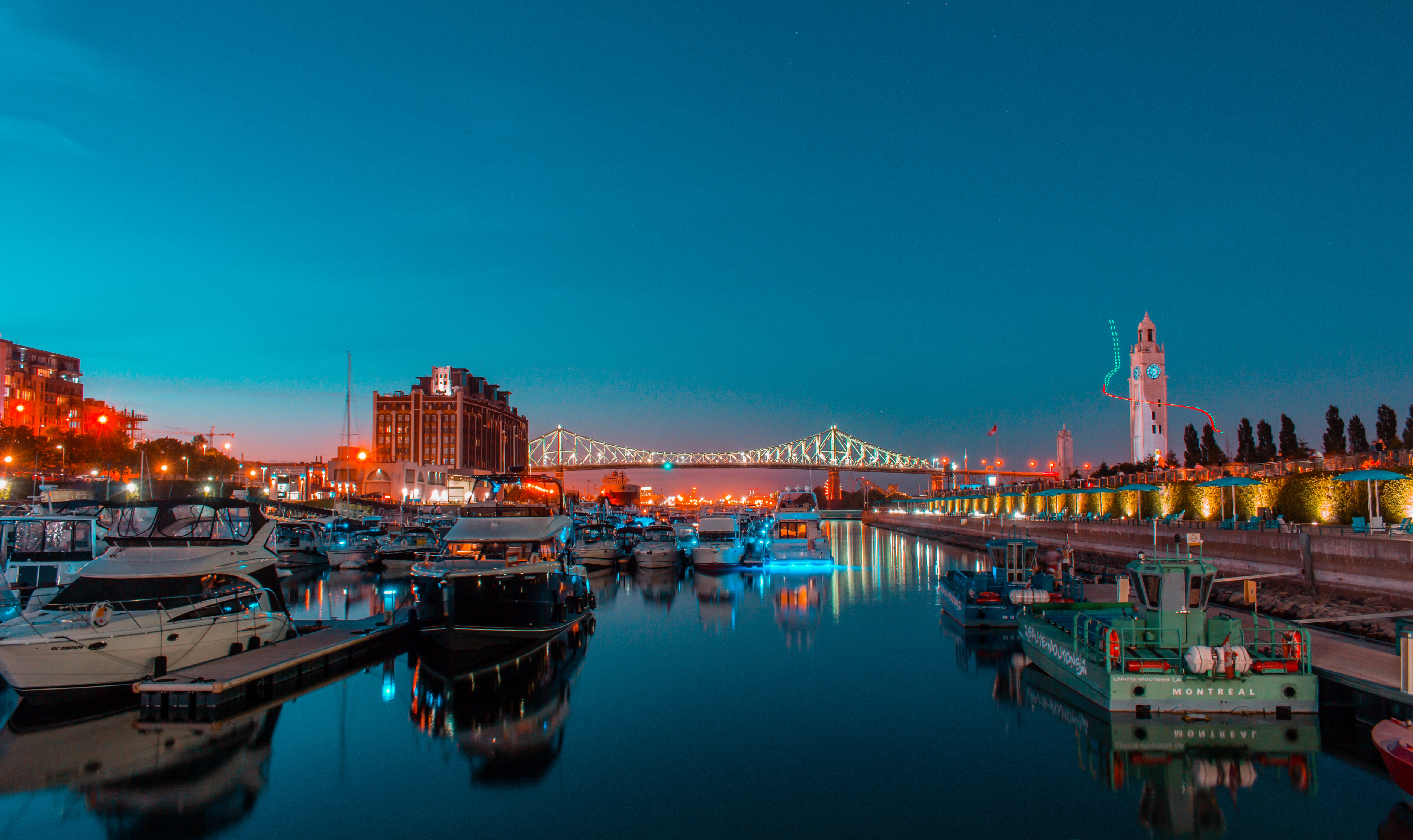
About Montréal, Québec
Canada's most diverse metropolis, Montréal, is an island city that favors style and elegance over order or even prosperity, a city where past and present intrude on each other daily. In some ways it resembles Vienna—well past its peak of power and glory, perhaps, yet still vibrant and grand.But don't get the wrong idea. Montréal has always had a bit of an edge. During Prohibition, thirsty Americans headed north to the city on the St. Lawrence for booze, music, and a good time, and people still come for the same things. Summer festivals celebrate everything from comedy and French music and culture to beer and fireworks, and, of course, jazz. And on those rare weeks when there isn't a planned event, the party continues. Clubs and sidewalk cafés are abuzz from late afternoon to the early hours of the morning. And Montréal is a city that knows how to mix it up even when it's 20 below zero. Rue St-Denis is almost as lively on a Saturday night in January as it is in July, and the festival Montréal en Lumière, or Montréal Highlights, enlivens the dreary days of February with concerts, balls, and fine food.Montréal takes its name from Parc du Mont-Royal, a stubby plug of tree-covered igneous rock that rises 764 feet above the surrounding cityscape. Although its height is unimpressive, "the Mountain" forms one of Canada's finest urban parks, and views from the Chalet du Mont-Royal atop the hill provide an excellent orientation to the city's layout and major landmarks.Old Montréal is home to museums, the municipal government, and the magnificent Basilique Notre-Dame-de-Montréal within its network of narrow, cobblestone streets. Although Montréal's centre-ville, or Downtown, bustles like many other major cities on the surface, it's active below street level as well, in the so-called Underground City–-the underground levels of shopping malls and food courts connected by pedestrian tunnels and the city's subway system, or métro. Residential Plateau Mont-Royal and trendy neighborhoods are abuzz with restaurants, nightclubs, art galleries, and cafés. The greener areas of town are composed of the Parc du Mont-Royal and the Jardin Botanique.


Where You'll Go


