Safaris & Savannas
Safaris & Savannas
Cruise overview
WHY BOOK WITH US?
- ✔ The Deluxe Cruises’ team has extensive experience in ultra-luxury cruising.
- ✔ Call now to speak to our helpful and experienced Cruise Concierge team.
- ✔ Enjoy our Unique Deluxe Cruises Bonus for substantial savings.
- ✔ Our team will tailor your holiday to your exacting requirements.
- ✔ As agents, we work under the protection of each cruise lines ABTA / ATOL licences
About Cape Town
Sometimes referred to as the Mother City, Cape Town is the most famous port in South Africa and is influenced by many different cultures, including Dutch, British and Malay. The port was founded in 1652 by Dutch explorer Jan Van Riebeeck, and evidence of Dutch colonial rule remains throughout the region. The port is located on one of the world's most important trade routes, and is mainly a container port and handler of fresh fruit. Fishing is another vital industry, with large Asian fishing fleets using Cape Town as a logistical repair base for much of the year. The region is famous for its natural beauty, with the imposing Table Mountain and Lions Head, as well as the many nature reserves and botanical gardens such as Kirstenbosch which boasts an extensive range of indigenous plant life, including proteas and ferns. Cape Town's weather is mercurial, and can change from beautiful sunshine to dramatic thunderstorms within a short period. A local adage is that in Cape Town you can experience four seasons in one day.


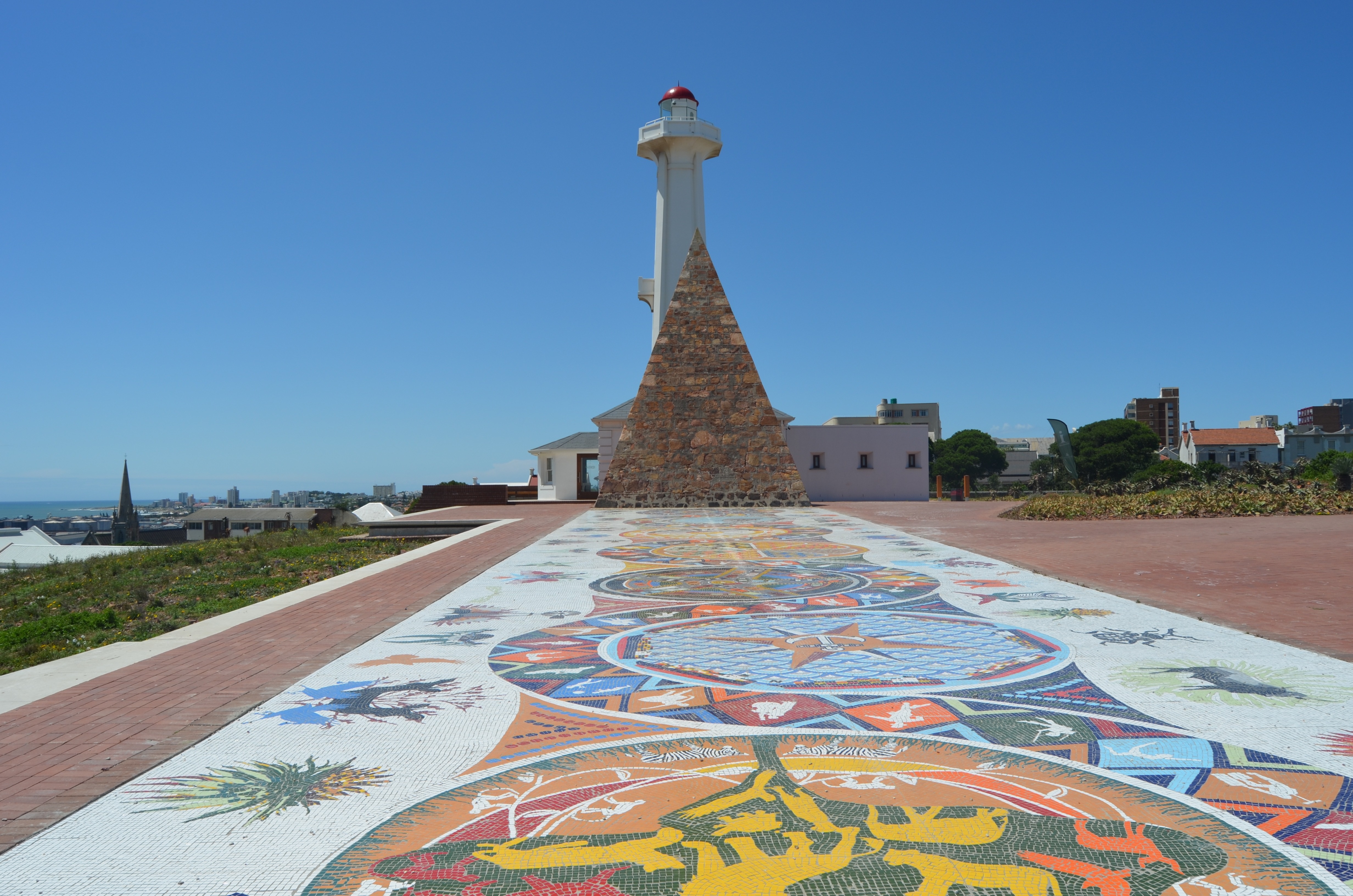
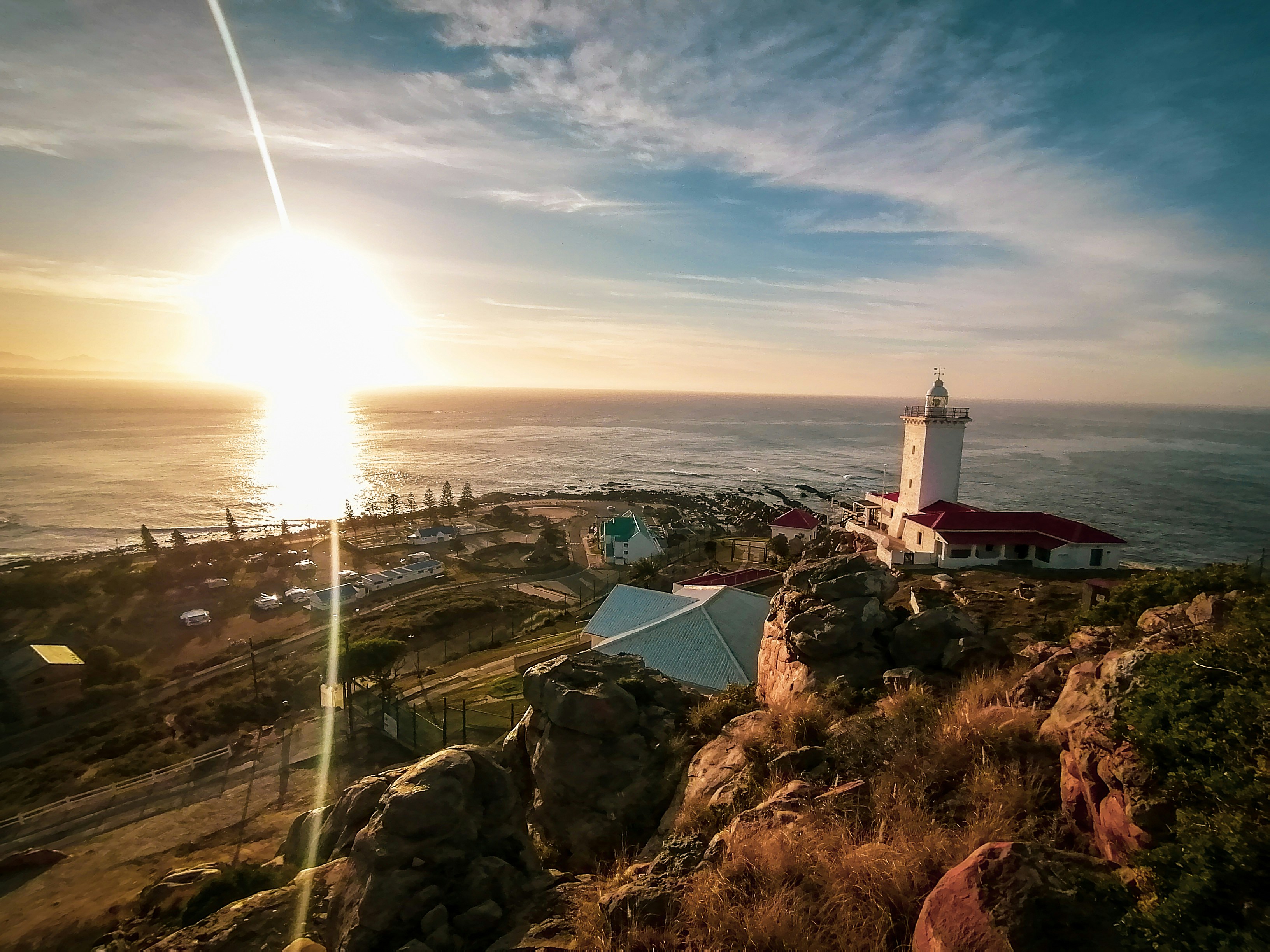
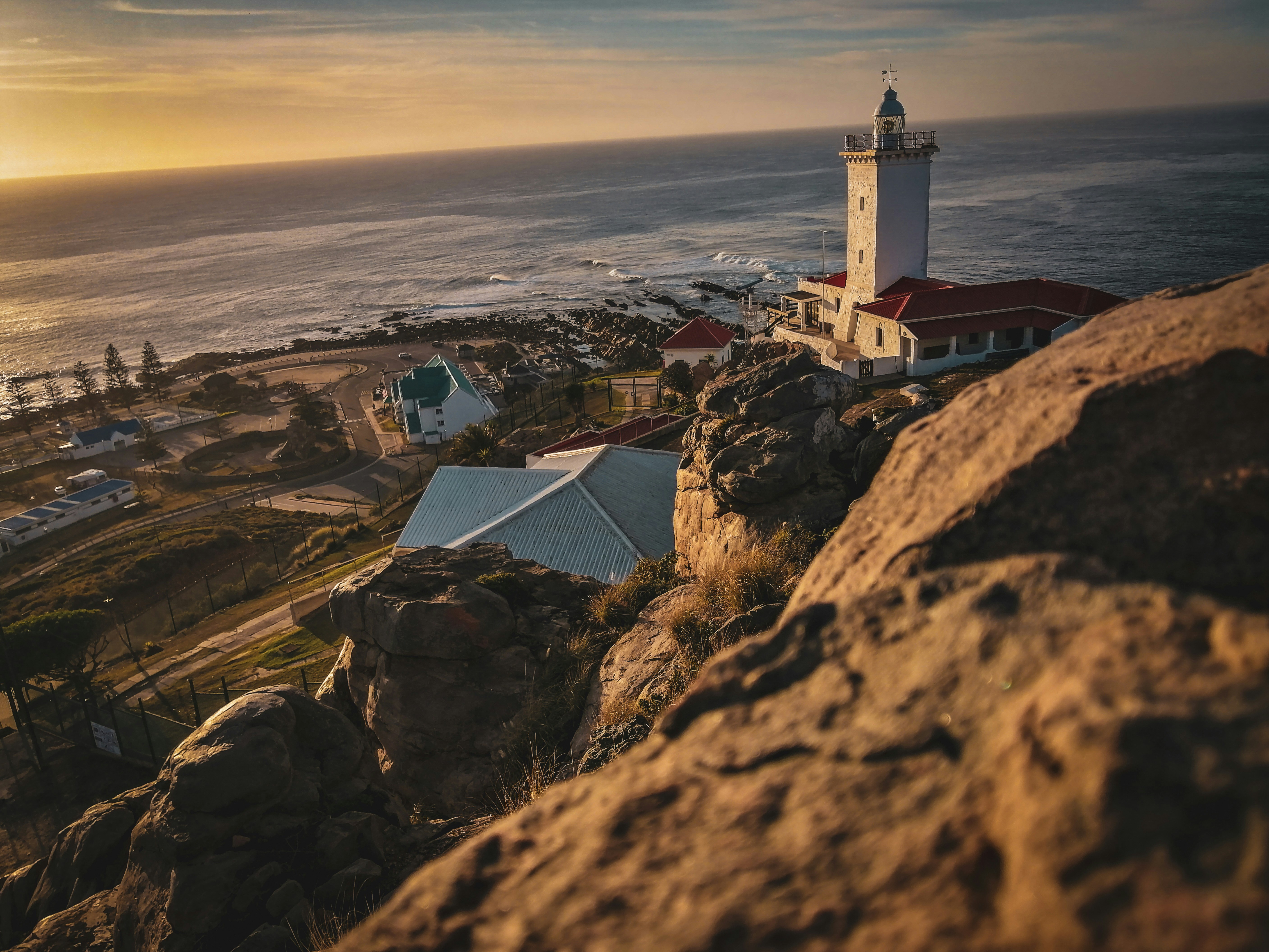
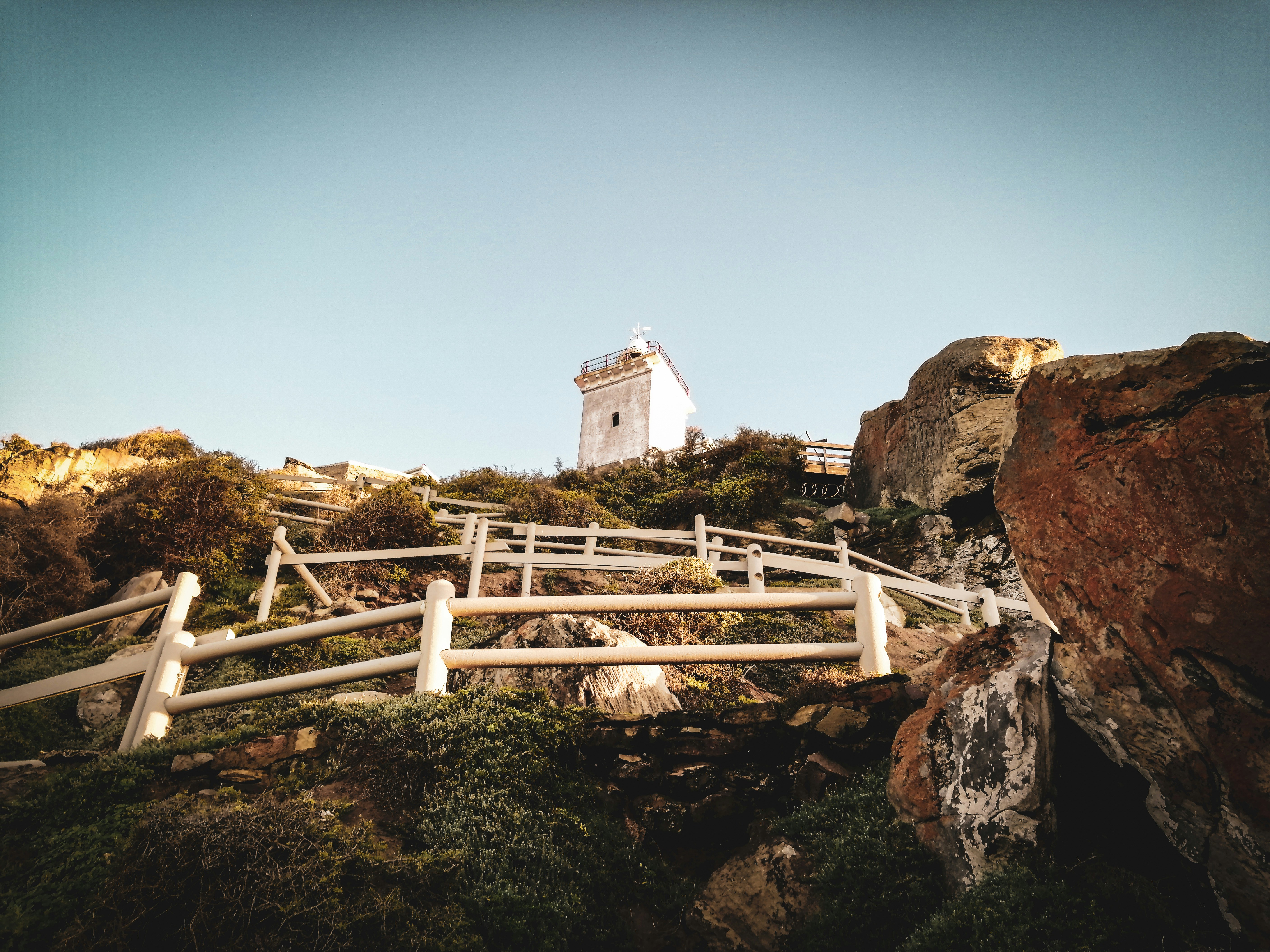
About Mossel Bay

About Gqeberha (ex Port Elizabeth)
Originally the home of the San and Khoisan people and later the Xhosa tribe, the area now known as Gqeberha (previously Port Elizabeth) became a landing place for passing European ships after Portuguese navigator Bartolomew Diaz arrived in Algoa Bay in 1488. As part of the Cape Colony, the British occupied the area during the Napoleonic Wars and it was they who built Fort Frederick here in 1799. Twenty-one years later 4,000 settlers arrived, becoming the first permanent British residents of South Africa and Gqeberha. Sir Rufane Donkin, Acting Governor of the Cape Colony, founded Port Elizabeth, naming the settlement after his late wife. The town underwent rapid growth after 1873 following the construction of the railway to Kimberley, and is now one of the country’s major seaports. Like most South African cities, miles of beautiful coastline surround Gqeberha. Algoa Bay combines warm water and fair breezes, making it a mecca for swimmers and water sports enthusiasts. Those interested in history can follow the Donkin Heritage Trail, past a succession of Victorian and Edwardian town houses, trim gardens and neo-Gothic churches. Just outside the town are a number of game reserves, including the famous Addo Elephant National Park.
About East London
South Africa’s only river port city is situated on the south-east Indian Ocean coast between the Buffalo and Nahoon Rivers. Its location is widely regarded as one of the most attractive on the Eastern Cape coast and it is ideally placed for exploring the coast towards Port Elizabeth and the surrounding Transkei region. The city you see today was born when the British-built Fort Glamorgan was constructed here in 1847 and it was British governor Sir Harry Smith who named the town London after the Empire’s capital as an open declaration about its promising position as a port. The town later became East London due to its location on the east of the Buffalo River, and in more recent times is sometimes referred to as Buffalo City. East London is renowned for its superb golden beaches such as Eastern, Orient and Nahoon, both popular with surfers, and a variety of places to dine and drink have sprung up along the bustling beachfront. While the city is predominantly modern you can see a number of historic buildings and monuments such as City Hall, whose clock tower commemorates the Diamond Jubilee of Queen Victoria.
About Richards Bay
South Africa’s largest harbour is located on a lagoon on the Mhlatuze River on the northern coast of KwaZulu-Natal and takes its name from Admiral Sir F W Richards who sailed into the bay to deliver supplies to the troops during the Anglo/Zulu War of 1879. The Richards Bay lagoon was declared a game reserve in 1935, when conservationists objected to the growing industrialisation here. This however did nothing to halt development. Instead a compromise was agreed and a wall was built across the length of the bay to divide the lagoon. The north side became the seaport and the south remained a sanctuary for waterfowl and wildlife. The lagoon is famous for being the site where the longest crocodile ever recorded was shot by hunter John Dunn - it measured over 20 feet. The town was built on the shores of the lagoon in 1954 and although it was only a small fishing community in the 1960s, the development of the deep water harbour and railway in 1976 prompted the growth of the much larger township you see today. The bustling town is now a popular holiday destination with its unspoilt beaches at the edge of the Indian Ocean, year-round sunshine and excellent recreational facilities including surfing and fishing. It is also an excellent gateway to Zululand and the KwaZulu wildlife reserves. Richards Bay has recently undergone a major renovation that has given the town a Caribbean feel.
About Tuléar
About Maputo
The city of Maputo was founded towards the end of the 18th century, and is influenced by a variety of cultures including Bantu, Arabian and Portuguese. Surrounded by beautiful colonial architecture and stunning natural scenery, it is an ideal base from which to explore the region. The scars from past wars and conflict are still evident, but the city is clearly regenerating, and the original beauty and cultural attractions of the area can easily be appreciated by visitors.

About Cape Town
Sometimes referred to as the Mother City, Cape Town is the most famous port in South Africa and is influenced by many different cultures, including Dutch, British and Malay. The port was founded in 1652 by Dutch explorer Jan Van Riebeeck, and evidence of Dutch colonial rule remains throughout the region. The port is located on one of the world's most important trade routes, and is mainly a container port and handler of fresh fruit. Fishing is another vital industry, with large Asian fishing fleets using Cape Town as a logistical repair base for much of the year. The region is famous for its natural beauty, with the imposing Table Mountain and Lions Head, as well as the many nature reserves and botanical gardens such as Kirstenbosch which boasts an extensive range of indigenous plant life, including proteas and ferns. Cape Town's weather is mercurial, and can change from beautiful sunshine to dramatic thunderstorms within a short period. A local adage is that in Cape Town you can experience four seasons in one day.
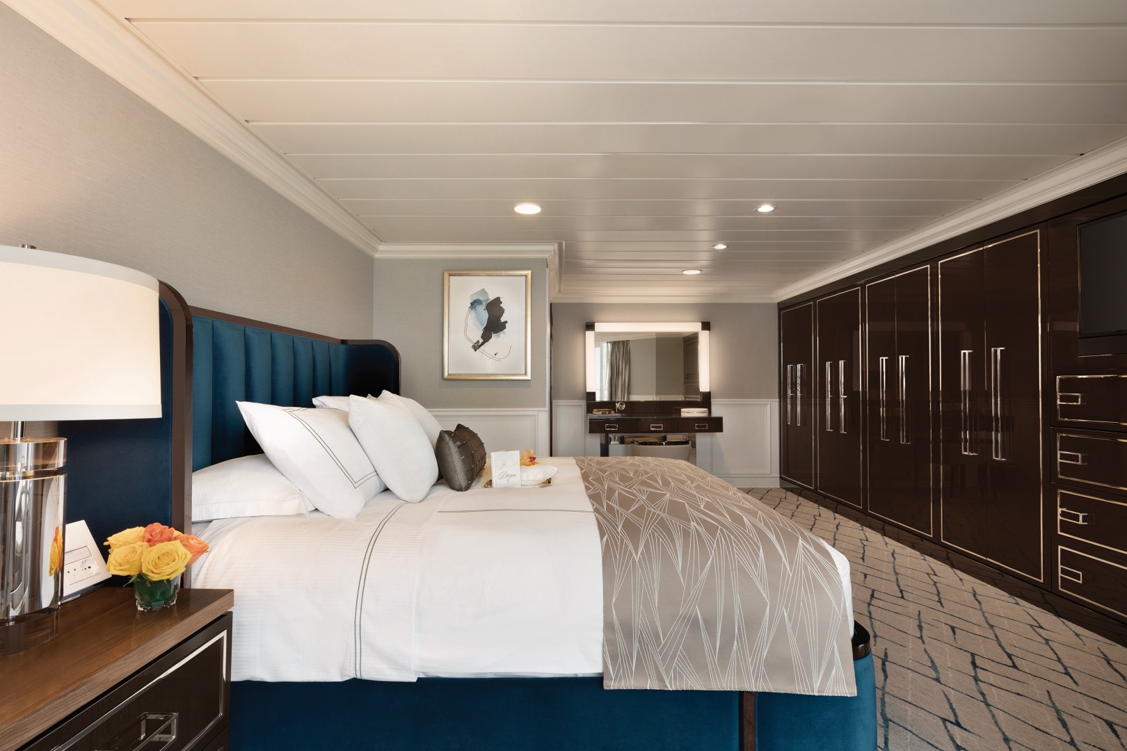
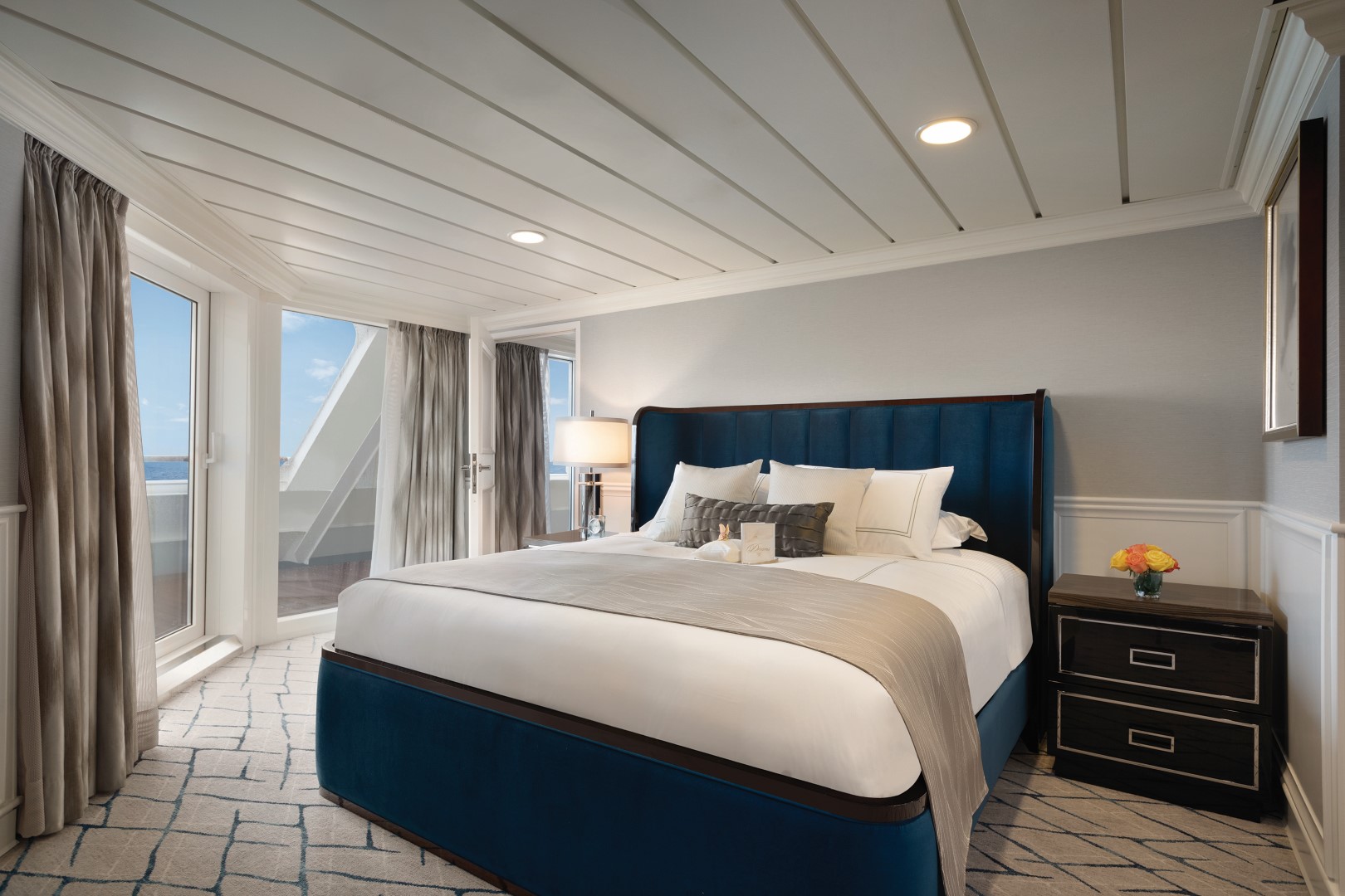
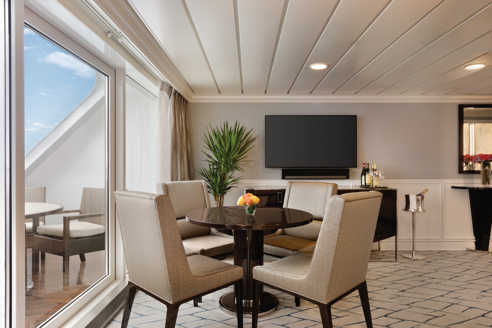
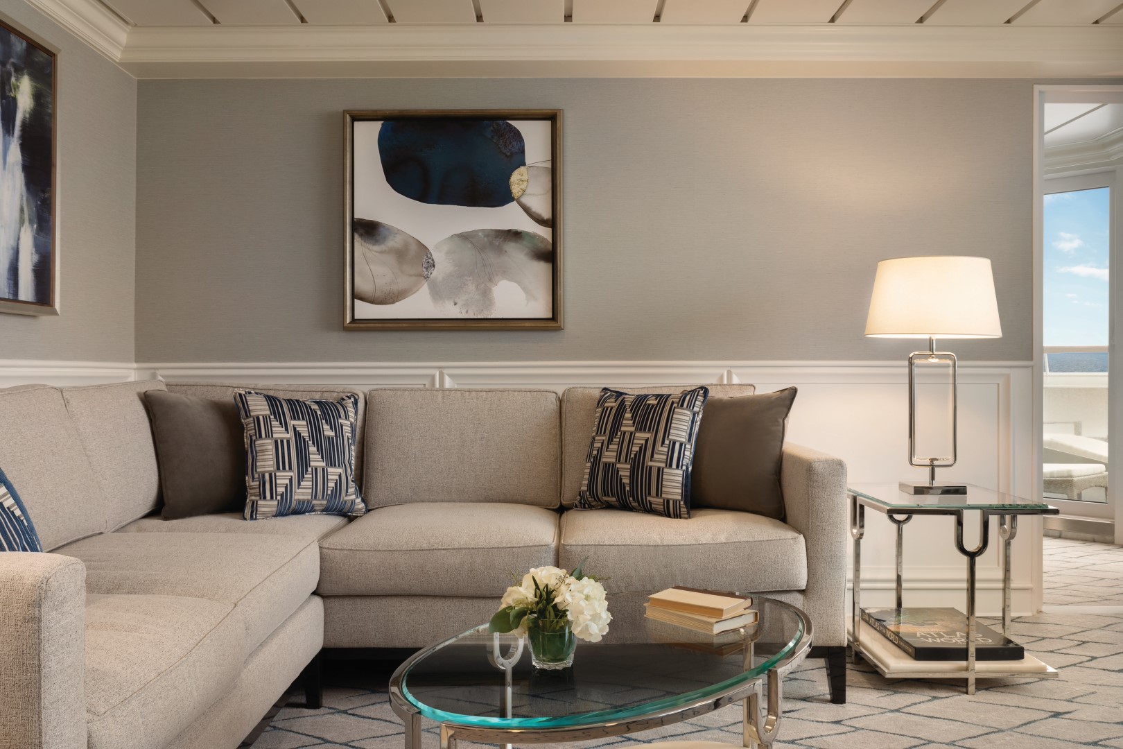
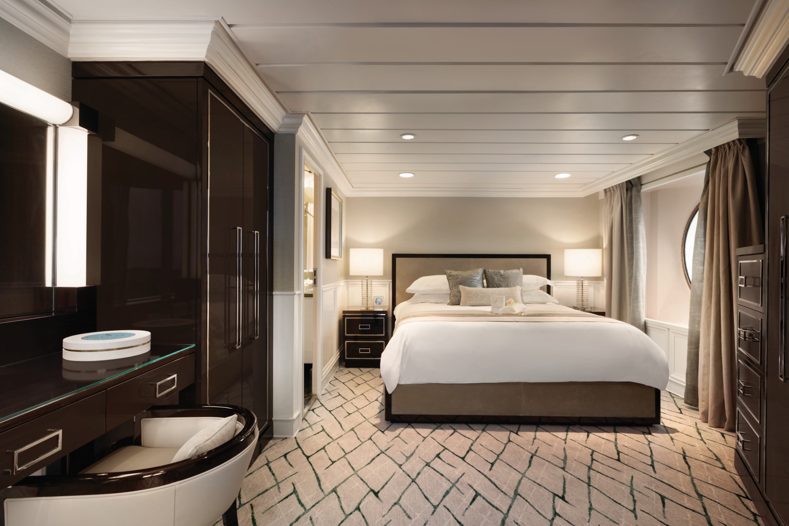
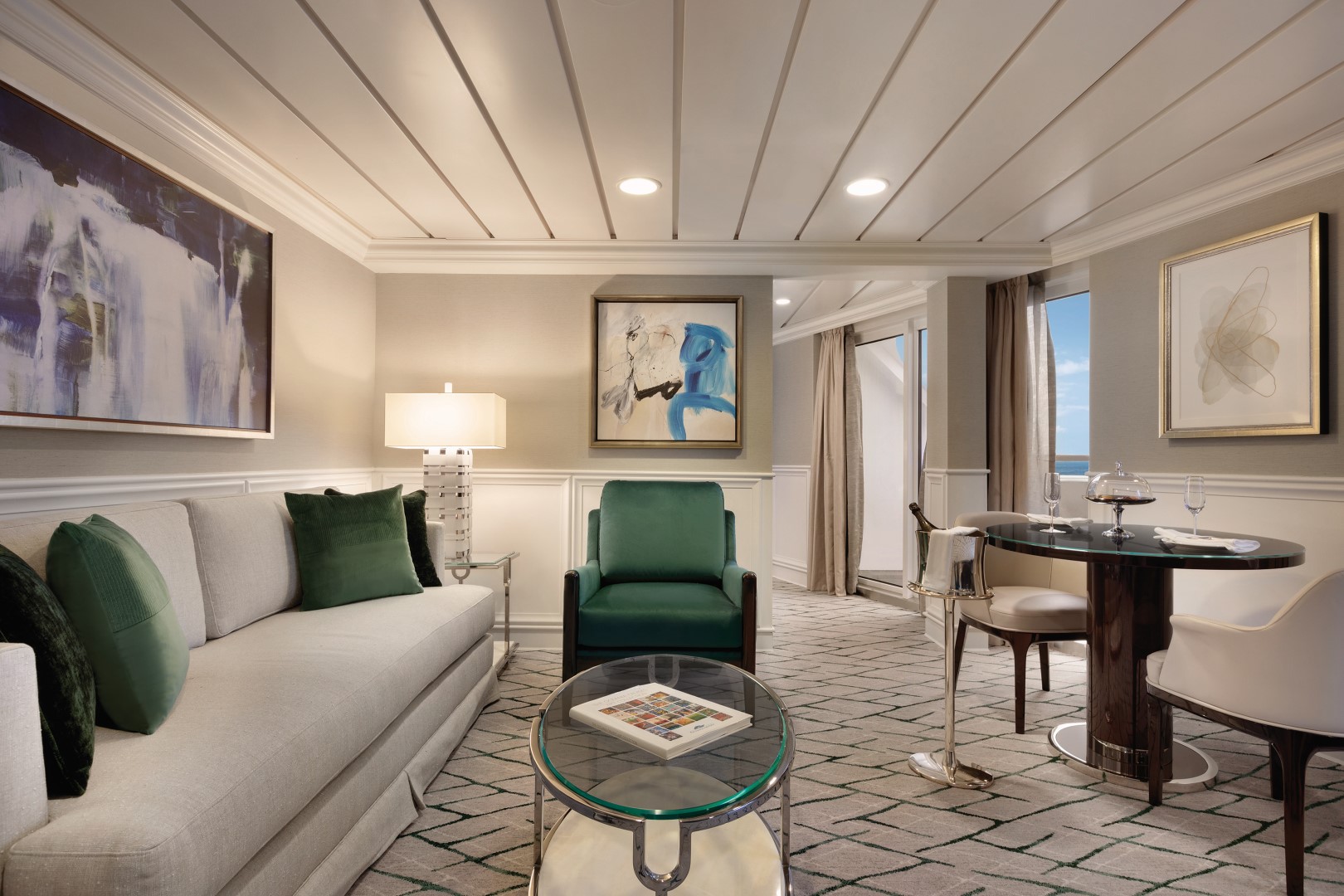
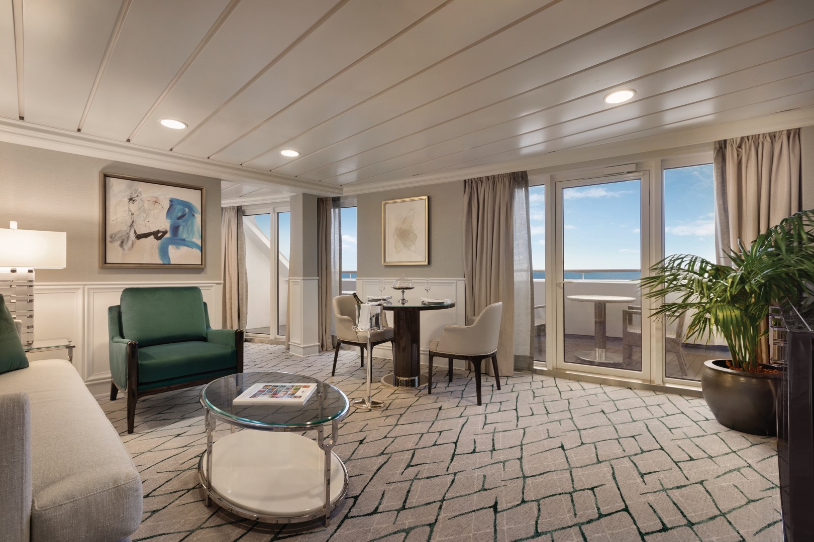
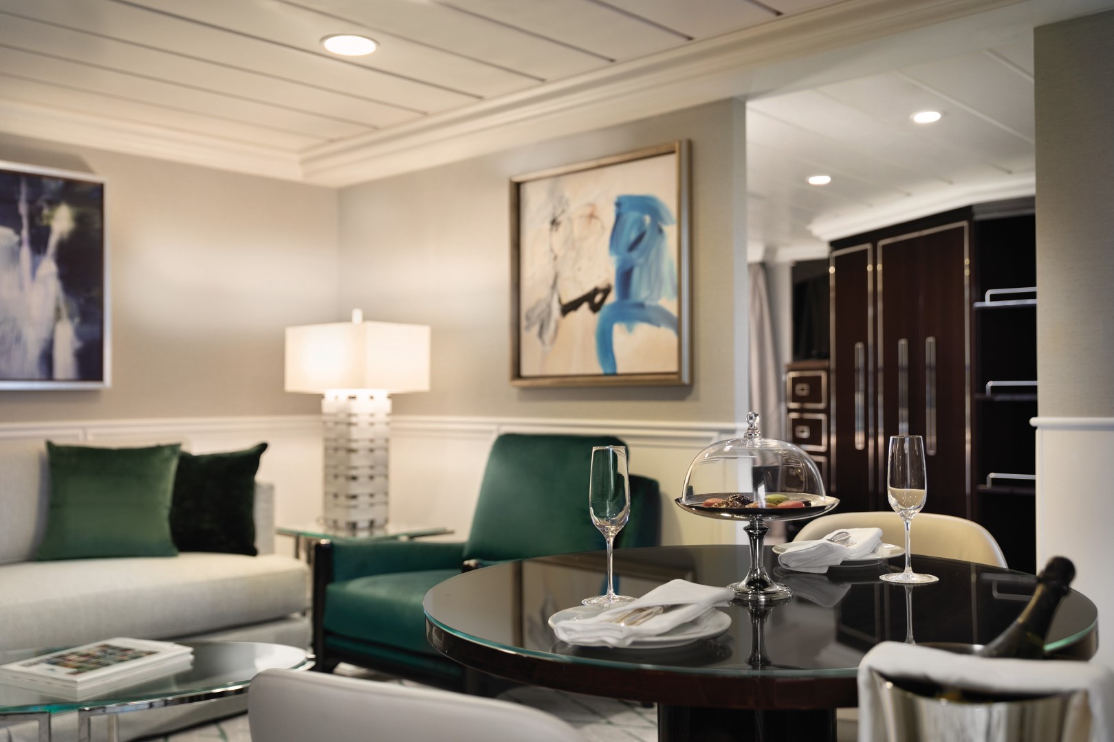
Lavish new fabrics and designer furnishings grace our six new Owner’s Suites – always among the first to be reserved. Immensely spacious and exceptionally luxurious, these suites span nearly 1,000 square feet and areas of quietude and relaxation. Every imaginable amenity is found here, further enhanced by a sumptuous re-designed bathroom with an oversized shower, a private teak veranda and two flat-screen televisions.
Owner's Suite Privileges
In addition to Stateroom Amenities
FREE laundry service – up to 3 bags per stateroom+
- Priority 11 am ship embarkation with priority luggage delivery
- 24-hour Butler service
- Optional private in-suite embarkation day lunch from noon to 2 pm
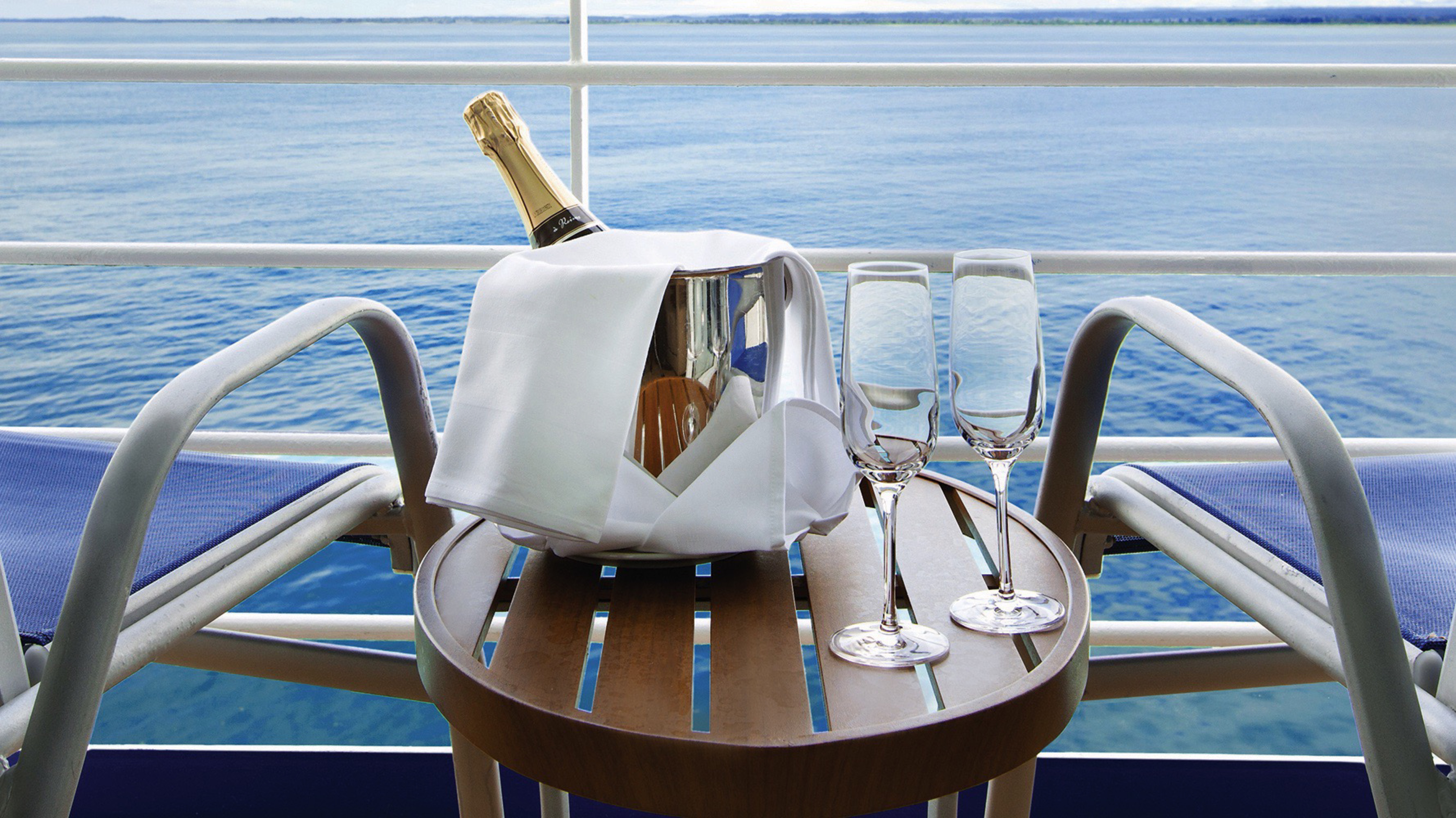
- Complimentary in-suite bar setup with 6 full-size bottles of premium spirits and wines from our suite beverage menu
- Complimentary welcome bottle of Champagne
- Fresh fruit basket replenished daily
- Priority online specialty restaurant reservations
- Unlimited access to the Aquamar Spa Terrace
- Luxury bath amenities
- Choice of daily printed newspaper
- Complimentary Oceania Cruises logo tote bag and personalized stationery
- Cashmere lap blankets, perfect for relaxing on your veranda
- Choice of pillow from a luxurious selection
- Complimentary shoeshine service
- Complimentary pressing of garments upon embarkation++
+Up to 20 garments per laundry bag; additional restrictions apply.
++Certain limitations apply.
Smoking in suites, staterooms and on verandas is strictly prohibited.
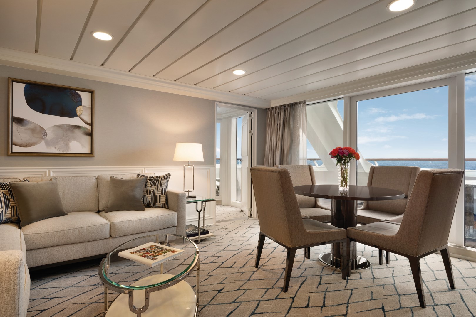
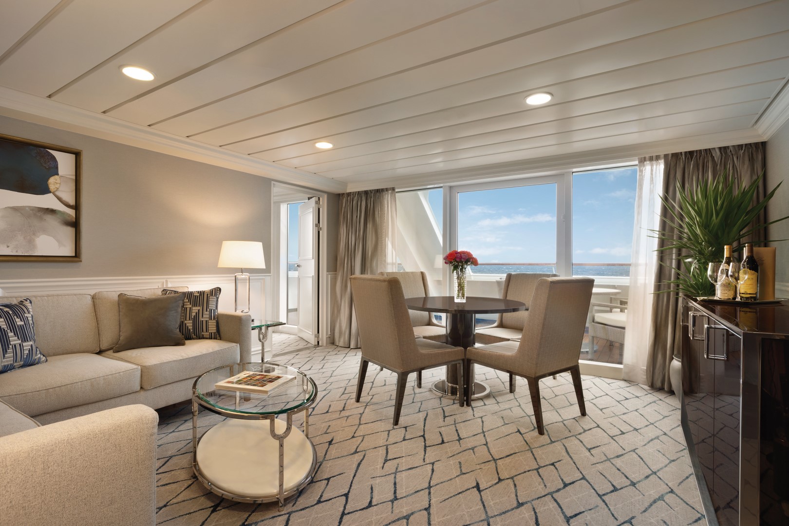
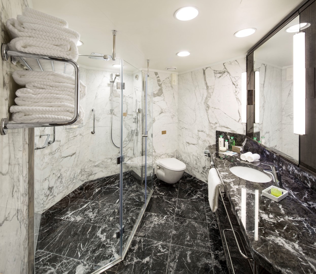
Named for their sweeping views over the ship's bow, the four Vista Suites each sprawl over 786 square feet. Every imaginable comfort is here, including a second bathroom for guests as well as a master bathroom newly redesigned in onyx and granite with a luxurious new shower. Relax on the private teak veranda, listen to music in enhanced surround sound or watch a movie on one of two flat-screen televisions. Access wireless Internet on a complimentary iPad®.
Vista Suite Privileges
In addition to Suite & Stateroom Amenities
- FREE laundry service – up to 3 bags per stateroom+
- Priority 11 am ship embarkation with priority luggage delivery
- 24-hour Butler service
- Complimentary in-suite bar setup with 6 full-size bottles of premium spirits and wines from our suite beverage menu
- Complimentary welcome bottle of Champagne
- Fresh fruit basket replenished daily
- Priority online specialty restaurant reservations
- Unlimited access to the Aquamar Spa Terrace
- Luxury bath amenities
- Choice of daily printed newspaper
- Complimentary Oceania Cruises logo tote bag and personalized stationery
- Cashmere lap blankets, perfect for relaxing on your veranda
- Choice of pillow from a luxurious selection
- Complimentary shoeshine service
- Complimentary pressing of garments upon embarkation++
+Up to 20 garments per laundry bag; additional restrictions apply.
++Certain limitations apply.
Smoking in suites, staterooms and on verandas is strictly prohibited.
Our collection of 322-square-foot Penthouse Suites is designed with splendid décor and exquisite furnishings in serene shades of the sea and sun. Spacious enough for private in-suite dining the living area features a refrigerated mini-bar and vanity desk, and the granite-clad bathroom is large enough for an indulgent full-size bathtub/shower. Relax on the beautifully furnished private teak veranda.
Penthouse Suite Privileges
In addition to Stateroom Amenities
- FREE laundry service – up to 3 bags per stateroom+
- 24-hour Butler service
- Complimentary welcome bottle of Champagne
- Priority online specialty restaurant reservations
- Unlimited access to the Aquamar Spa Terrace
- Complimentary Oceania Cruises logo tote bag
- Cashmere lap blankets, perfect for relaxing on your veranda
- Complimentary shoeshine service
- Complimentary pressing of garments upon embarkation++
+Up to 20 garments per laundry bag; additional restrictions apply.
++Certain limitations apply.
Smoking in suites, staterooms and on verandas is strictly prohibited.
Upgrade Your Experience
Located in some of the most desirable locations on the ship, Category A Concierge Level Veranda Staterooms offer the attractive blend of both value and luxury. These sleekly redefined 216-square-foot staterooms offer coveted amenities and exclusive privileges, such as free laundry service, that make your experience that much more carefree. Fresh new decor, sumptuous Tranquility Beds and re-inspired verandas with stylish new furniture complete the Concierge experience.
Exclusive Concierge Privileges
In addition to Stateroom Amenities
FREE laundry service – up to 3 bags per stateroom+
- Expanded lunch and dinner room service menu from The Grand Dining Room
- Complimentary welcome bottle of Champagne
- Priority online specialty restaurant reservations
- Unlimited access to the Aquamar Spa Terrace
- Complimentary Oceania Cruises logo tote bag
- Cashmere lap blankets, perfect for relaxing on your veranda
- Complimentary pressing of garmets upon embarkation++
- Complimentary shoeshine service
+Up to 20 garments per laundry bag; additional restrictions apply.
++Certain limitations apply.
Smoking in suites, staterooms and on verandas is strictly prohibited.
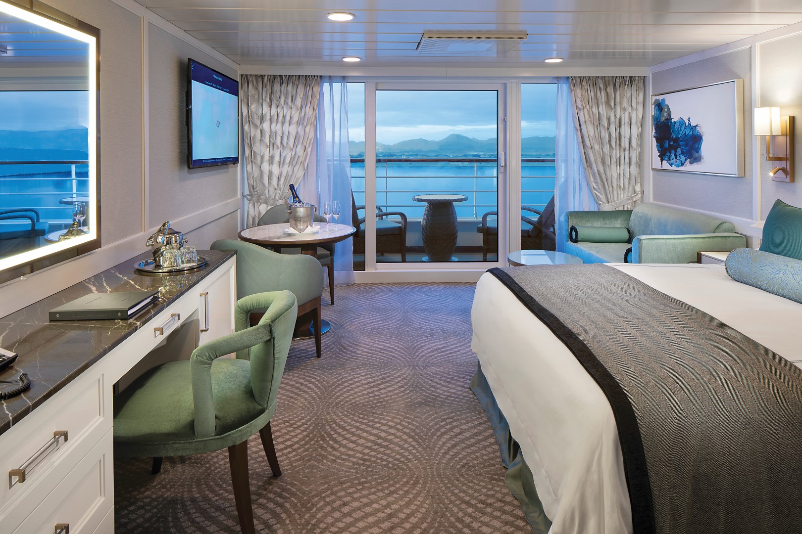
Custom-crafted furnishings, exotic stone finishes, supple upholstered headboards and chic lighting are just a few of the enhancements within these 216-square-foot staterooms that also boast our most popular luxury – a private teak veranda for watching the ever-changing panoramas. Conveniences within each stateroom include a vanity desk, refrigerated mini-bar, breakfast table and spacious seating area.
Veranda Stateroom Amenities
Tranquility Bed, an Oceania Cruises exclusive, with 1,000-thread-count linens
- Complimentary soft drinks replenished daily in your refrigerated mini-bar
- Complimentary still & sparkling Vero Water
- Private teak veranda
- Bulgari amenities
- Free room service menu 24 hours a day
- Twice-daily maid service
- Belgian chocolates with turndown service
- Interactive television system with on-demand movies, weather and more
- Wireless Internet access and cellular service
- Writing desk and stationery
- Plush cotton towels
- Thick cotton robes and slippers
- Handheld hair dryer
- Security safe
Smoking in suites, staterooms and on verandas is strictly prohibited.
With entirely re-designed closets, dressers and vanities, these 165-square foot staterooms feel even more spacious. A generous seating area, vanity desk, refrigerated mini-bar and breakfast table are perfectly complemented by the soothing hues and stylish fabrics of the sleek new decor.
Deluxe Oceanview Stateroom FREE Amenities:
- FREE soft drinks replenished daily in your refrigerated mini-bar
- FREE still & sparkling Vero Water
- FREE room service menu 24 hours a day
Deluxe Oceanview Stateroom Included Amenities:
- Tranquility Bed, an Oceania Cruises Exclusive
- Bulgari amenities
- Twice-daily maid service
- Category (C1) includes accessibility features in stateroom #4052 and #4056.
- Interactive television system with on-demand movies, weather and more
- Wireless Internet access and cellular service
- Writing desk and stationery
- Plush cotton towels, robes and slippers
- Handheld hair dryer
- Security safe
- Belgian chocolates with turndown service
Deluxe Oceanview Accessibility Features:
- Bed with hoist space
- Large bathroom door
- Toilet grab rails
- Roll in bathrooms with no lip riser which has a wraparound drainage system as well as a bathtub
Smoking in suites, staterooms and on verandas is strictly prohibited.
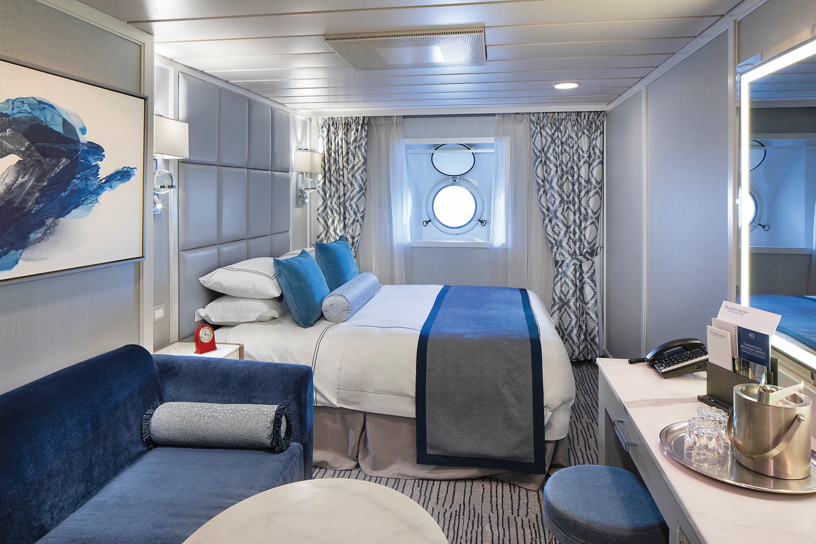
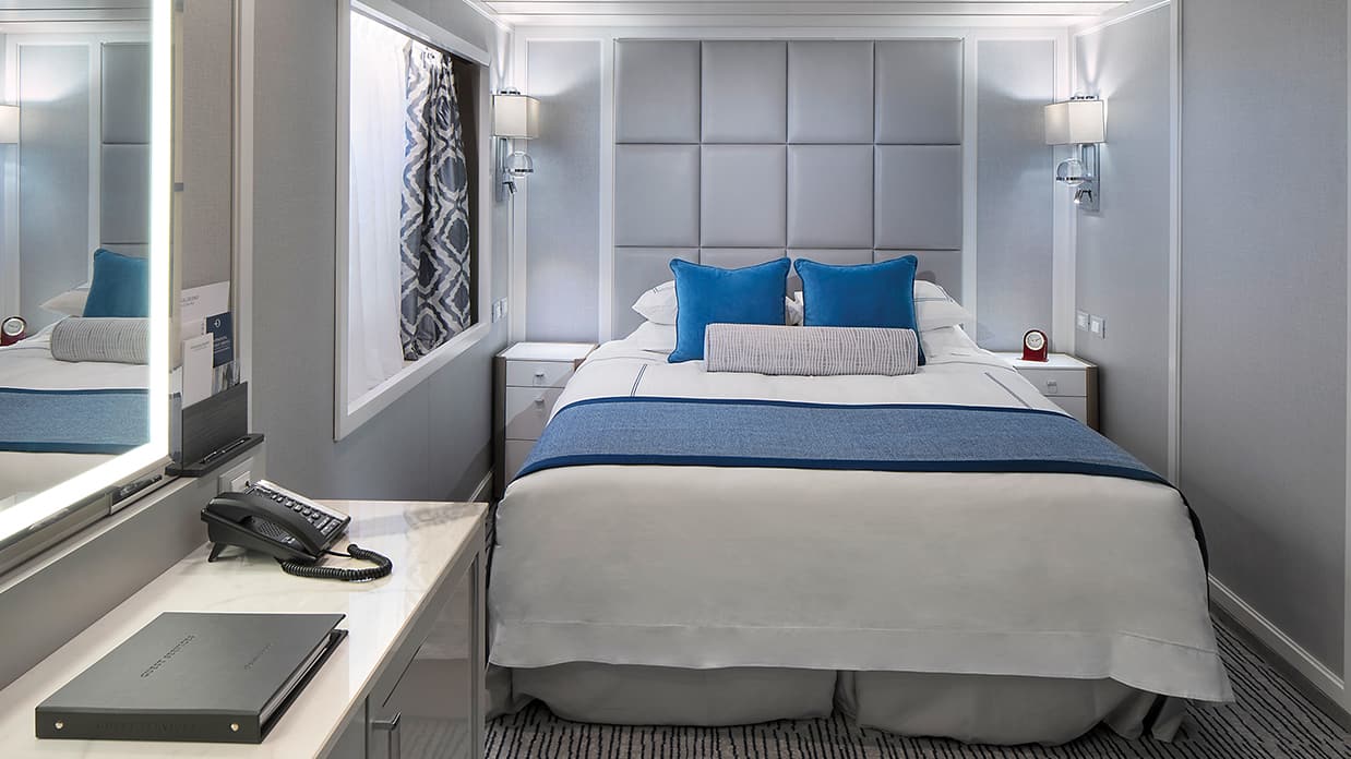
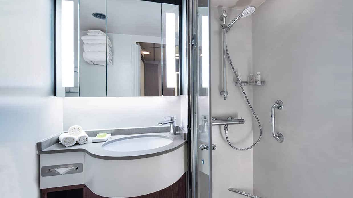
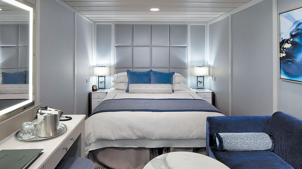
Featuring a classic porthole, these exquisitely appointed 165-square-foot staterooms showcase sophisticated new decor and a modern design that maximizes both space and convenience. Enjoy a comfortable seating area with a sofa on which to stretch out, as well as a vanity desk, breakfast table and refrigerated mini-bar.
Oceanview FREE Amenities:
- FREE soft drinks replenished daily in your refrigerated mini-bar
- FREE still & sparkling Vero Water
- FREE room service menu 24 hours a day
Oceanview Included Amenities:
- Tranquility Bed, an Oceania Cruises Exclusive
- Bulgari amenities
- Twice-daily maid service
- Interactive television system with on-demand movies, weather and more
- Wireless Internet access and cellular service
- Writing desk and stationery
- Plush cotton towels, robes and slippers
- Handheld hair dryer
- Security safe
- Belgian chocolates with turndown service
- Smoking in suites, staterooms and on verandas is strictly prohibited.
Solo Oceanview FREE Amenities:
- FREE soft drinks replenished daily in your refrigerated mini-bar
- FREE still & sparkling Vero Water
- FREE room service menu 24 hours a day
Solo Oceanview Included Amenities:
- Tranquility Bed, an Oceania Cruises Exclusive
- Bulgari amenities
- Twice-daily maid service
- Interactive television system with on-demand movies, weather and more
- Wireless Internet access and cellular service
- Writing desk and stationery
- Plush cotton towels, robes and slippers
- Handheld hair dryer
- Security safe
- Belgian chocolates with turndown service
- Smoking in suites, staterooms and on verandas is strictly prohibited.
Beautifully re-designed with a modern flair, these private retreats boast 160 square feet of luxury. Highlights include a comfortable seating area, vanity desk, refrigerated minibar and plenty of storage. The ingenious use of space is complemented by the re-inspired decor.
Inside Stateroom Amenities
- Ultra Tranquility Bed, an Oceania Cruises Exclusive
- Complimentary and extensive 24-hour room service menu
- Plush cotton towels
- Thick cotton robes and slippers
- Bulgari amenities
- Handheld hair dryer
- Flat-screen television with live satellite news and programming
- DVD player with extensive media library
- Wireless Internet access and cellular service
- Writing desk and stationary
- Security safe
- Category (G) includes accessibility features in staterooms #4028, #4034 and #4035. View Features
All Suites and Staterooms are Smoke-Free
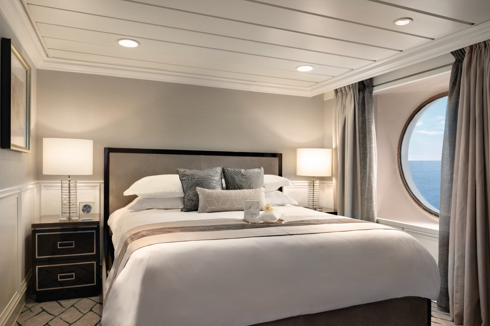
ULTRA TRANQUILITY BED
Awaken refreshed and revitalised from the new custom-designed Ultra Tranquility Bed, featured in all of Oceania Cruises’ suites and staterooms.
- Custom-designed mattress featuring 3,000 encapsulated micro-springs, which ensure a peaceful night's sleep with zero noise upon movement
- Quilted with advanced silver-threaded fabric and specially designed thermo-fibre for luxurious comfort
- Plush down comforter
- Hand-quilted throws
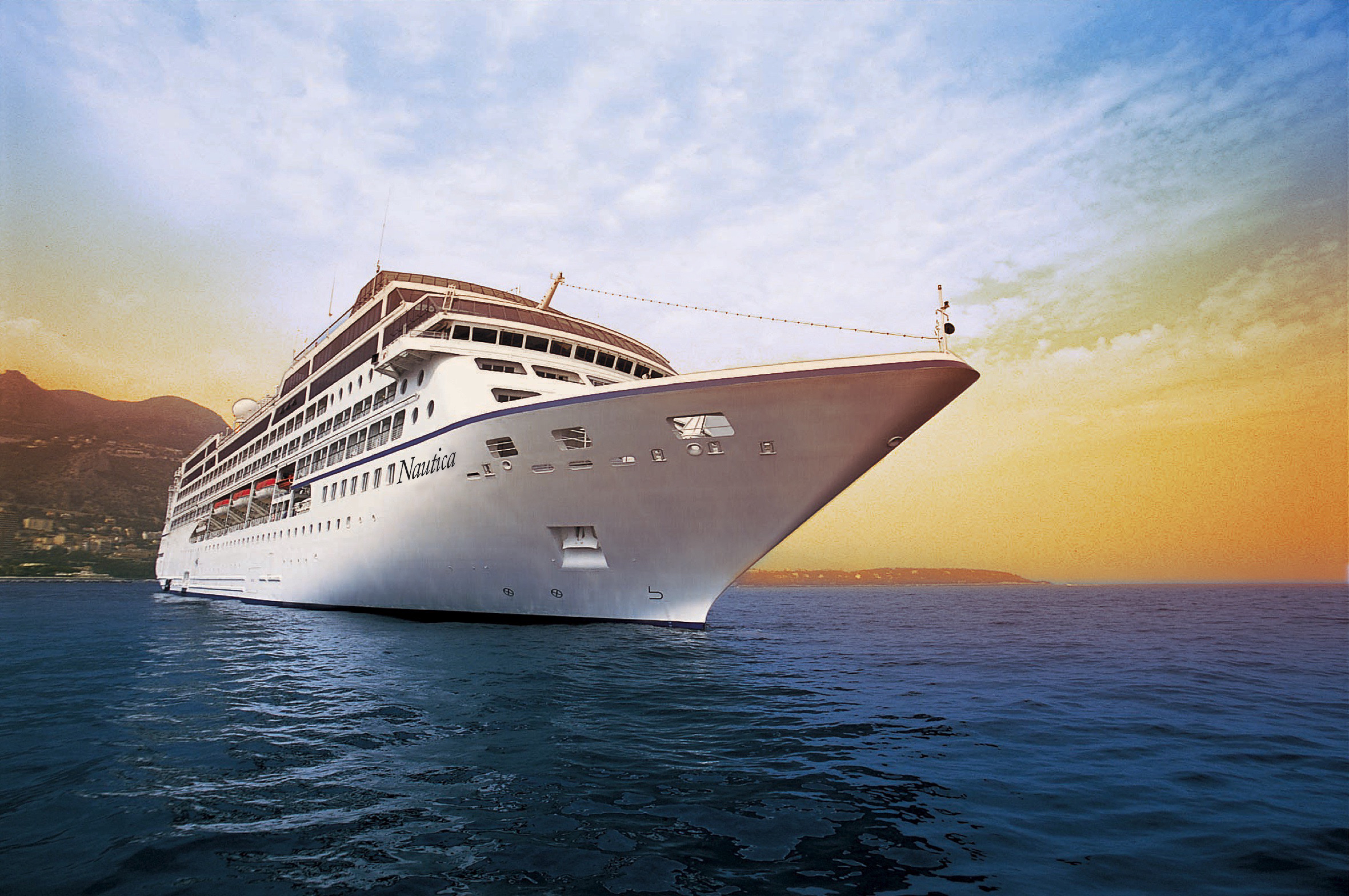
Oceania Nautica
Elegantly charming, Oceania Nautica’s lounges, suites and staterooms boast luxurious, residential furnishings and her decks are resplendent in the finest teak, custom stone and tile work. Oceania Nautica offers every luxury you may expect on board one of our stylish ships. She features four unique, open-seating restaurants, the Aquamar Spa + Vitality Center, eight lounges and bars, a casino and 333 luxurious suites and chic staterooms, nearly 70% of which feature private verandas. With just 670 guests to pamper, our 400 professionally trained staff ensure you will wait for nothing.
The better-than-new Oceania Nautica blends sophistication with a contemporary flair to create a casually elegant ambiance that embodies the most treasured elements of our celebrated ships. Every surface of every suite and stateroom is entirely new, while in the public spaces, a refreshed color palette of soft sea and sky tones surrounds a tasteful renewal of fabrics, furnishings and lighting fixtures that exquisitely encompasses the inimitable style and comfort of Oceania Cruises.
Ship Facts
| Launch Year | 1999 | ||||||||
| Refit Year | 2022 | ||||||||
| Language | en | ||||||||
| Gross Tonnage | 30277 | ||||||||
| Length | 181 | ||||||||
| Width | 25.5 | ||||||||
| Currency | USD | ||||||||
| Speed | 18 | ||||||||
| Capacity | 670 | ||||||||
| Crew Count | 400 | ||||||||
| Deck Count | 9 | ||||||||
| Cabin Count | 342 | ||||||||
| Large Cabin Count | 0 | ||||||||
| Wheelchair Cabin Count | 4 | ||||||||
| Electrical Plugs |
|
Deck 11
- Shuffleboard
- Sun Deck
- Golf Putting Greenes
- Showers

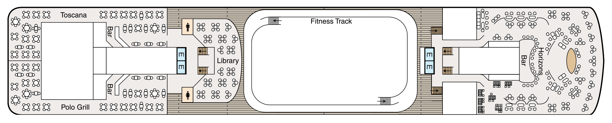
Deck 10
- Toscana
- Bars
- Polo Grill
- Library
- Fitness Track
- Horizons Bar
- Elevator
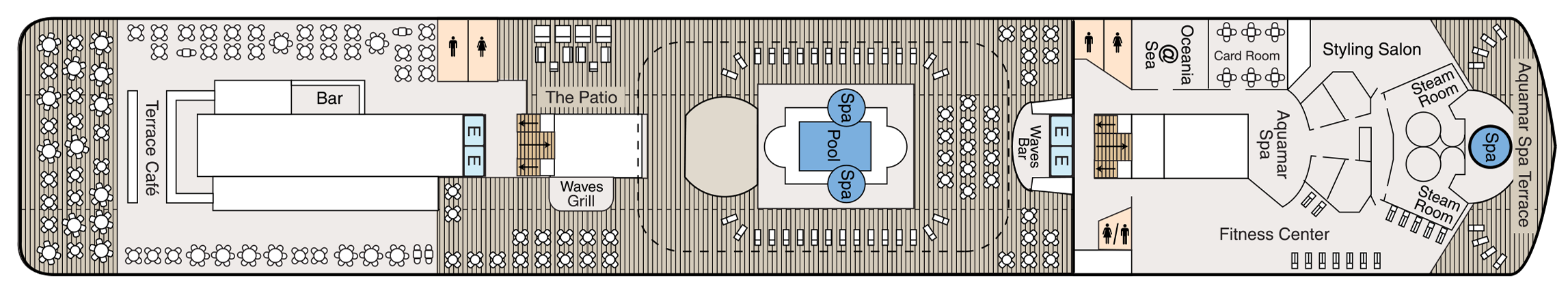
Deck 9
- Terrace Café
- Bar
- The Patio
- Waves Grill
- Whirlpools
- Pool
- Waves Bar
- Oceania@Sea
- Card Room
- Aquamar Spa
- Fitness Centre
- Styling Salon
- Steam Rooms
- Spa Terrace
- Elevator
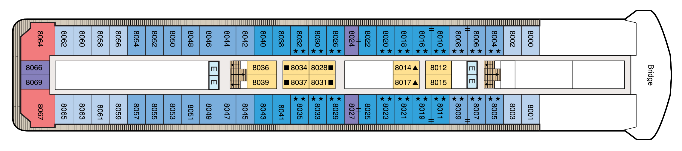
Deck 8
- Bridge
- Concierge Level Veranda Staterooms
- Inside Staterooms
- Owner's Suites
- Penthouse Suites
- Elevator
Deck 7
- Concierge Level Veranda Staterooms
- Deluxe Ocean View Staterooms
- Inside Staterooms
- Owner's Suites
- Vista Suites
- Elevator

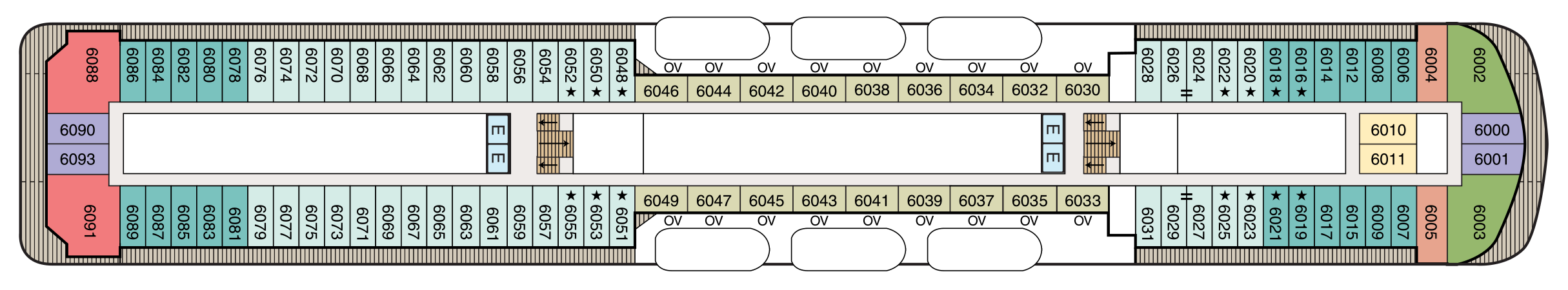
Deck 6
- Concierge Level Veranda Staterooms
- Veranda Staterooms
- Deluxe Ocean View Staterooms
- Ocean View Staterooms
- Inside Staterooms
- Owner's Suites
- Vista Suites
- Elevator
Deck 5
- Grand Dining Room
- Baristas Grand/ Bar
- Upper Hall
- Boutiques
- Martinis
- Casino
- Lounge
- Dance Floor
- Stage
- Elevator

Deck 4
- Destination Services
- Concierge
- Reception Hall
- Reception Desk
- Medical Centre
- Deluxe Ocean View Staterooms
- Inside Staterooms
- Elevator

Deck 3
- Ocean View Stateroom
- Tender Embarkation Area
- Elevator

Culinary Masterpieces
The superb gourmet restaurants aboard Oceania Nautica serve delectable dishes created à la minute and offer a remarkable array of choices, from Continental cuisine and vibrant regional specialties to casual all-American favorites. Every restaurant on board Oceania Nautica is complimentary and features open seating so you may dine wherever and whenever suits your taste and schedule. Enjoy dinner for two or a gathering with newfound friends, knowing the experience is certain to be extraordinary.
The Luxury of Casual
You’ll savor cuisine renowned as the finest at sea no matter where you choose to dine or relax on Oceania Nautica– whether that means a poolside burger, a scoop of Humphry Slocombe’s bourbon-flavored cornflake-studded Secret Breakfast ice cream or a perfectly prepared cappuccino accompanied by freshly baked biscotti. Our culinary team’s attention to detail, passion for artisanal ingredients and dedication to technique extends to our casual dining, poolside experiences, Baristas coffee bar and the cherished ritual of Afternoon Tea at Horizons too.
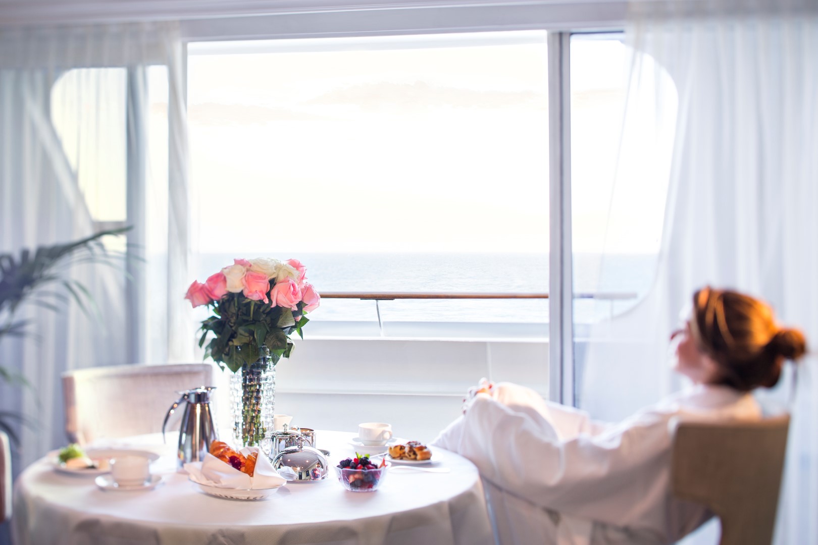
In-Room Dining Experiences
After a day of enriching adventures ashore or an enjoyable day on board, dining in the privacy of your suite or stateroom with our compliments is always a welcome possibility. A complete menu of varied dining experiences is available around the clock, featuring an extensive array of delectable breakfast, lunch and dinner items. All suites and staterooms have the added luxury of enjoying a full, hot breakfast in-room and those staying in Concierge Level or above have the additional privilege of ordering from an expanded lunch and dinner room service menu from The Grand Dining Room. Suite guests have the ultimate indulgence of enjoying course-by-course meals from the comfort of their spacious sanctuaries. Revel in the private luxury of your suite or stateroom, and enjoy an exquisite meal on your tranquil veranda as you take in spectacular seascapes.
The Grand Dining Room
An Elegant Setting
The Grand Dining Room is a study in stateliness, a tribute to the spirit of Europe’s marquee five-star hotel restaurants that inspired its dignified yet convivial ambiance. Handsomely decorated in rich woods, designer tapestry fabrics and oversized armchairs, the expansive dining area exudes classic splendor. This signature dining experience has always offered a bevy of delicious Continental dishes, and now a fresh and new array of options brings you even more exciting choices, as well as an incredible spectrum of global flavors and an all new Executive Chef’s Tasting Menu. As variety is essential to your satisfaction, menus change daily with an expansive choice of at least 10 appetizers, soups and salads and 10 dinner entrées, along with healthy options such as Aquamar Vitality Cuisine, gourmet vegetarian selections and the most extensive array of plant-based dishes at sea.
Open for breakfast, lunch and dinner. No reservations required.
Polo Grill
A Classic Steakhouse
Polo Grill embodies all the elements of a classic steakhouse, expressing them with timeless reverence. Mindful of tradition, the decor features crisp, white linen tablecloths, dark wood furnishings and supple, high-back, burgundy leather chairs. Each course stands as the very definition of time-honored favorites, most notably the beef dishes, all of which are certified Black Angus USDA Prime and dry aged to enhance tenderness and flavor. Succulent seafood dishes such as grilled swordfish and whole Maine lobster gratinée are also classics in their own right. The classic Caesar salad, too, is prepared according to tradition, tableside and with gusto.
Open for dinner only. Reservations required.
Toscana
Authentic Italian
Toscana means Tuscan, and just as Tuscan cuisine evolved from rich family traditions, many of our recipes originated with the mothers and grandmothers of our own Italian culinary staff. Presented on elegant, custom-designed Versace china, masterfully prepared dishes exemplify the essence of Tuscany and celebrate Italy’s culinary passion. Perhaps the evening begins with the octopus carpaccio with Champagne vinaigrette or the artichoke and parmesan cheese timbale with black truffle sauce. Classic dishes from other regions of Northern Italy are featured as well, such as the minestrone alla Genovese, lasagna alforno alla Bolognese and osso buco alla Milanese.
Open for dinner only. Reservations required.
Terrace Café
Informal Dining
Informal and carefree, the Terrace Café is wonderfully inviting any time of day. During breakfast, the room is infused with natural sunlight from the floor-to-ceiling windows, stimulating the appetite for the sumptuous selections. Come lunch, the expansive menu of international-inspired dishes changes entirely, complemented by a flavorful roast and the magic of the pizzeria’s oven. Dine inside or alfresco at one of the shaded teak tables on the terrace. During the evenings, the cuisine takes on a more sophisticated flair, with lobster tails, chops and fresh fish prepared to order, and freshly made hand-cut sushi and sashimi. In addition, a diverse selection of bold and flavorful plant-based dishes is available.
Open for breakfast, lunch and dinner. No reservations required.
Waves Grill
Alfresco Dining
Sometimes, the ultimate luxury is casual dining on all-American favorites, a laid-back style Waves Grill epitomizes. Located in a spacious, shaded area steps from the swimming pool, Waves Grill offers an extensive and mouthwatering menu. Then try a decadent dessert such as a homemade passion fruit sorbet, a made-to-order hot fudge sundae, a hand-dipped milkshake or one of the new, whimsical ice cream flavors by Humphry Slocombe, such as Secret Breakfast, Elvis (the Fat Years) or our signature flavor, Regatta Royale.
The Pizzeria at Waves Grill
Visit Waves Grill in the evening to experience an atmospheric Neapolitan trattoria with a warm pizza oven at the epicenter. Pair savory antipasti or creamy burrata selections with a crisp glass of sauvignon blanc or refreshing rosé. Hand-tossed pizzas feature delectable toppings ranging from smoky roasted bell peppers and earthy truffle oil to fiery chorizo. The irresistible aromas will draw you in and the flavorful creations will make you want to linger over dinner just as they do in Italy.
Breakfast
7:00 am – 11:00 am
Lunch
11:30 am – 4:00 pm
The Pizzeria at Waves Grill
6:30 pm – 9:00 pm
Afternoon Tea
Time-Honored Pastime
Teatime is a celebratory daily event that irresistibly draws guests to Horizons at four o’clock sharp. As a classical string quartet plays softly in the background, our staff glides through the room presenting bountiful four-tiered pastry carts filled with freshly made finger sandwiches, colorful petits fours, richly textured scones with clotted cream and wonderfully sinful desserts. Of course, a selection of artisanal teas is the centerpiece of this splendid afternoon pastime.
Daily at 4pm. No reservations required.
Baristas
Specialty Coffee
This delightful coffee bar is a favourite stop for java lovers. Enjoy complimentary illy® espressos, cappuccinos and lattes prepared by our master baristas, as well as the delicious pastries, finger sandwiches and homemade biscotti that draw so many to Baristas throughout the day. Whether your favourite coffee creation is a macchiato or a cool and refreshing illy crema, the chic and bold ambiance of Baristas is perfect for relaxing in quietude or socialising with newfound friends.
Open daily until early evening. No reservations required.
Room Service
After a day of enriching adventures ashore or an enjoyable day on board, dining in the privacy of your suite or stateroom with our compliments is always a welcome possibility. A complete menu of varied dining experiences is available around the clock, featuring an extensive array of delectable breakfast, lunch and dinner items. All suites and staterooms have the added luxury of enjoying a full, hot breakfast in-room and those staying in Concierge Level or above have the additional privilege of ordering from an expanded lunch and dinner room service menu from The Grand Dining Room. Suite guests have the ultimate indulgence of enjoying course-by-course meals from the comfort of their spacious sanctuaries. Revel in the private luxury of your suite or stateroom, and enjoy an exquisite meal on your tranquil veranda as you take in spectacular seascapes.
Complimentary room service is available 24 hours a day.
Life On Board
Each day aboard our ships is a spectacle and adventure to experience, from world-class music, high-energy production shows and dazzling cabarets to rousing deck games, spirited wine tastings and evenings at our atmospheric casino. For those seeking more cerebral pursuits, engaging talks by passionate Guest Speakers, chef-led demonstrations inspired by the local cuisine and animated Team Trivia sessions invite you to experience each new horizon more fully.
Music & Entertainment
Evenings aboard Oceania Nautica can be anything you desire. Marvel at the continuously changing talented guest entertainers as you delight in high-energy production shows, talented vocalists, classical music and more. Perhaps stop by the lively Monte Carlo-style Casino for a rousing game or two. Unforgettable evenings are just steps from your stateroom.
Bars & Lounges
From chic Martinis to the laid-back poolside Waves Bar, there's a perfect enclave on board Oceania Nautica for every mood. Visit the elegant Grand Bar for a pre-dinner cocktail, catch a headline act in the Lounge or watch the sun set in Horizons accompanied by a glass of wine and lively music. As you explore the world, these bars and lounges are the place to unwind, gather together, laugh and take in one-of-a-kind shows and musical performances.
Casinos At Sea®
MONTE CARLO-STYLE GAMING
Earn Casino Points
The professional staff is happy to provide lessons on how games are played, the rules and proper table procedures. Unwind from a busy day ashore by playing your favorite games of chance and skill in our casino. Enjoy a fun and exciting range of ways to play, from card and table games such as blackjack and roulette to slot machines.
Getting started is easy. Stop by the casino cage and pick up your Oceania Cruises casino player card and start earning points today by inserting your player card while playing your favorite slot machines and table games. The more you play, the more you earn!
- Reel & Video Slots - For every $5 coin-in, receive 1 point.
- Video Poker - For every $10 coin-in, receive 1 point.
- Table Games - Points are based on average bet, session play or hands played and game type.
- Action packed casinos designed with style
- Table game limits for players of all levels
- Diverse array of reel slot, video slot and video poker machines
Dedicated and knowledgeable casino staff
- Industry leading player tracking system
- Free gaming lessons
REDEEM CASINO POINTS
You’ve played. You’ve earned. Now you’re ready to redeem. Downloading points for play is quick and easy. Redeem your casino points for play right at your machine by following the on-screen prompts or stop by the casino cage – the choice is yours.
- Earn points for all your casino play
- Redeem points for play right at your machine
CASINO CASH & CREDIT
Front Money deposits are accepted for gaming in the form of cash, traveler’s checks, cashier’s checks and wire transfers delivered to us prior to embarkation. All cashier’s checks require prior verification. For more information please give us a call at 877.625.2094.
Cashless Wagering
Charge gaming to your onboard account directly from your game of choice or at the casino cashier, using your stateroom key card. Convenience fees, daily limits and cruise limits apply. Euros may be exchanged at the casino cashier, exchange rates apply. All gaming is in US Dollars.
- Cashless wagering allows you to game with your key card
Credit
Casino Credit is available to all players with an existing reservation. The minimum application amount is $10,000.00 and a personal check is required onboard to activate the credit line. Applications are processed 1 month prior to sailing. The application process is easy and there is no fee to apply. To get started, click here for our credit application or for more information email us at casinocredit@ncl.com or call us at 877.625.2094.
- Casino credit available
Boutiques
Unique Gifts, Jewelry & More
Our stylish boutiques feature a tastefully curated selection of items ranging from sundries to chic resort wear and fine jewelry. Discover thoughtful gifts for friends and family or the perfect memento to remind you of your special cruise experience.
Oceania@Sea Internet Centre
Stay Connected
Stay in touch with family and friends, monitor business developments and more in our 24-hour Internet centre, Oceania@Sea.
For personalised service, Oceania@Sea is fully staffed as follows:
- Sea Days: 8 a.m: - 7 p.m.
- Port Days: 8 a.m: - 11 a.m. and 3 p.m. - 7 p.m
Oceania Cruises also offers wireless Internet access throughout the ship, allowing you to connect through your laptop or mobile device. And as an added convenience, guests in all Owner's and Vista Suites will have the use of an iPad® throughout the voyage. iPad® is available upon request for Penthouse Suites and Concierge Level Staterooms (limited availability).
Letters and postcards with the appropriate postage can be mailed at the Reception Desk. Postage for mail may be purchased at the Reception Desk for a nominal fee. Mail will be collected one hour prior to sailing from each port of call. Incoming mail or faxes received by the ship on your behalf will be delivered directly to your stateroom.
PHONE
Oceania Cruises offers Wireless Maritime Services (WMS) for all GSM mobile phones and GPRS devices such as Blackberry® when the ship is at sea. You can make and receive phone calls, send and receive text messages and use other data services when the ship is at sea. You will be billed by your mobile phone provider and calls or messages will appear as roaming charges on your bill. While using the WMS service, international maritime roaming rates will apply. Please consult your wireless service provider for detailed rates and service zones.
Entertainment & Onboard Shows
Production Shows On Board Oceania Nautica
Dazzling Performances
World-class musical performances will delight you, showcasing an ever-changing array of guest entertainers such as pianists, classical string quartets, dynamic vocalists and spectacular headliners.
Each of our ships features a unique lineup of onboard shows and entertainers to ensure that your interests are constantly piqued. Bold and crowd-thrilling, nostalgic and upbeat, or intimate and sophisticated – whatever you choose, the night is yours.
Oceania Nautica's versatile and talented cast performs the following diverse production shows:
Broadway in Concert
Come on along and listen to…the lullabies of Broadway! In this elegant concert-style review, our fabulous production cast vocalists pay tribute to some of the most iconic musicals of all time. You’ll experience songs you know and love, and maybe you'll discover one or two more contemporary gems. Let us entertain you…because, after all, “There’s no business like show business!”
Showdown
Your vote counts in this mock singing competition, where you, the audience, chooses the winner. Join our production cast and cheer on your favorite singer as he or she belts out some pop favorites in hopes of taking home the title. Will they sway your vote? Find out because it’s time for a SHOWDOWN!
Good Lovin’
Good Lovin’ is an infectious tribute to the irresistible beat of soulful pop and Motown classics that filled the airwaves throughout the 1960s. It is the ultimate soundtrack for the baby boomer generation and rocks some of the best music of its time.
Gatsby’s
The upbeat and quirky musical score is compiled from timeless tunes, inspired by the 1920s and includes blues, jazz and Tin Pan Alley standards like “Makin' Whoopie,” “Won’t You Charleston,” “Puttin’ on the Ritz” and “I Wanna Be Loved by You” and the melodies of Duke Ellington and Fats Waller.
Library
Quietude At Sea
Pick up a steaming cappuccino and settle in to the welcoming ambiance of our classic library on board Oceania Nautica with the novel or bestseller you’ve been meaning to read. Read, relax and feel right at home with more than 2,000 books and periodicals to choose from as you sail from one destination to the next.
Just as sailing aboard Oceania Cruises recalls the elegance of the Golden Age of Travel, our inspired English-style library is reminiscent of a charming English country estate where you can while away the hours in ultimate comfort. There is something magical about the dark, rich woods; the plush high back chairs; the cozy fireplaces and rows of books lining the walls, each a new world waiting to be discovered.
Card Room
Enjoy a thrilling game of Bridge and more.
Sun Deck
Soak up the sun, refreshing sea breeze and stunning panoramic vistas high atop the ship.
Patio
Sit back, relax and enjoy the stunning panoramic ocean views in the shaded, comfortable Patio as you sail to the next exciting destination.
Martinis
Martinis serves numerous incarnations of this famous cocktail in an airy, elegant atmosphere reminiscent of the Greek Isles with a palette of bold blues, deep pewter and serene sienna.
The Grand Bar
Before sitting down to a gourmet meal, sample a rare vintage or savor your favorite apéritif as you enjoy spirited conversation with newfound friends amid the refined atmosphere of the convivial Grand Bar.
Lounge
From headline acts to comedians, magicians and lively jazz ensembles, head to the Lounge to discover the center of nightly entertainment aboard Oceania Cruises.
Horizons
An elegant observation lounge with dramatic floor to ceiling windows and a country club casual ambiance. Horizons transforms into a sophisticated evening venue by night. Dance the night away to the sounds of a lively musical group and enjoy cocktails with friends at the welcoming bar.
Waves Bar
Located in a shaded area just steps from the swimming pool, Waves Bar offers a wide variety of libations to enhance your poolside experience. Revel in the perfect afternoon on deck with your favorite cocktail, glass of wine or chilled beer. Come happy hour, signature cocktails and frosty beverages create a delightfully carefree segue to the lively evening ahead as the sun sets.