Untamed North Atlantic
Untamed North Atlantic
Cruise overview
WHY BOOK WITH US?
- ✔ The Deluxe Cruises’ team has extensive experience in ultra-luxury cruising.
- ✔ Call now to speak to our helpful and experienced Cruise Concierge team.
- ✔ Enjoy our Unique Deluxe Cruises Bonus for substantial savings.
- ✔ Our team will tailor your holiday to your exacting requirements.
- ✔ As agents, we work under the protection of each cruise lines ABTA / ATOL licences
About Reykjavík
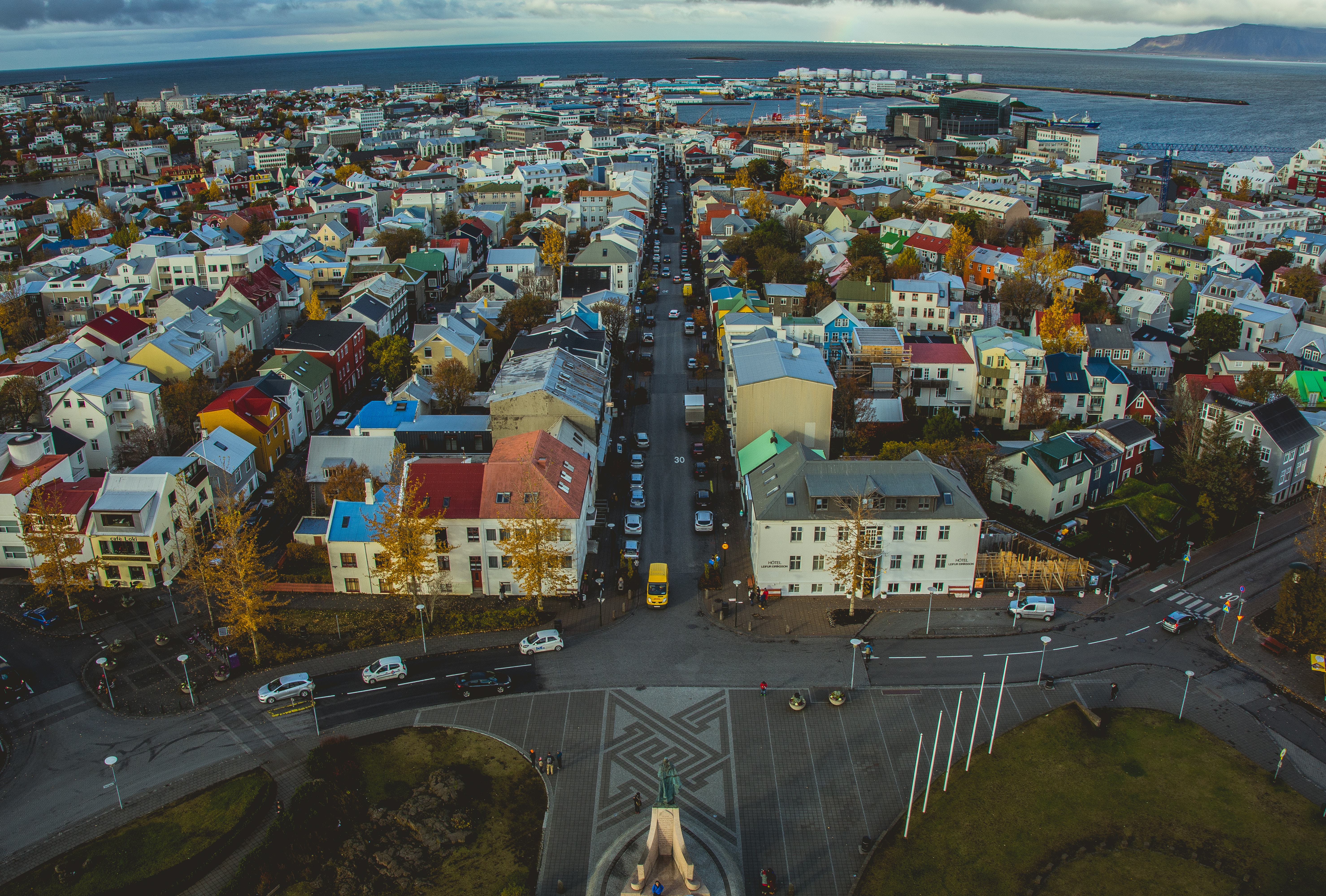
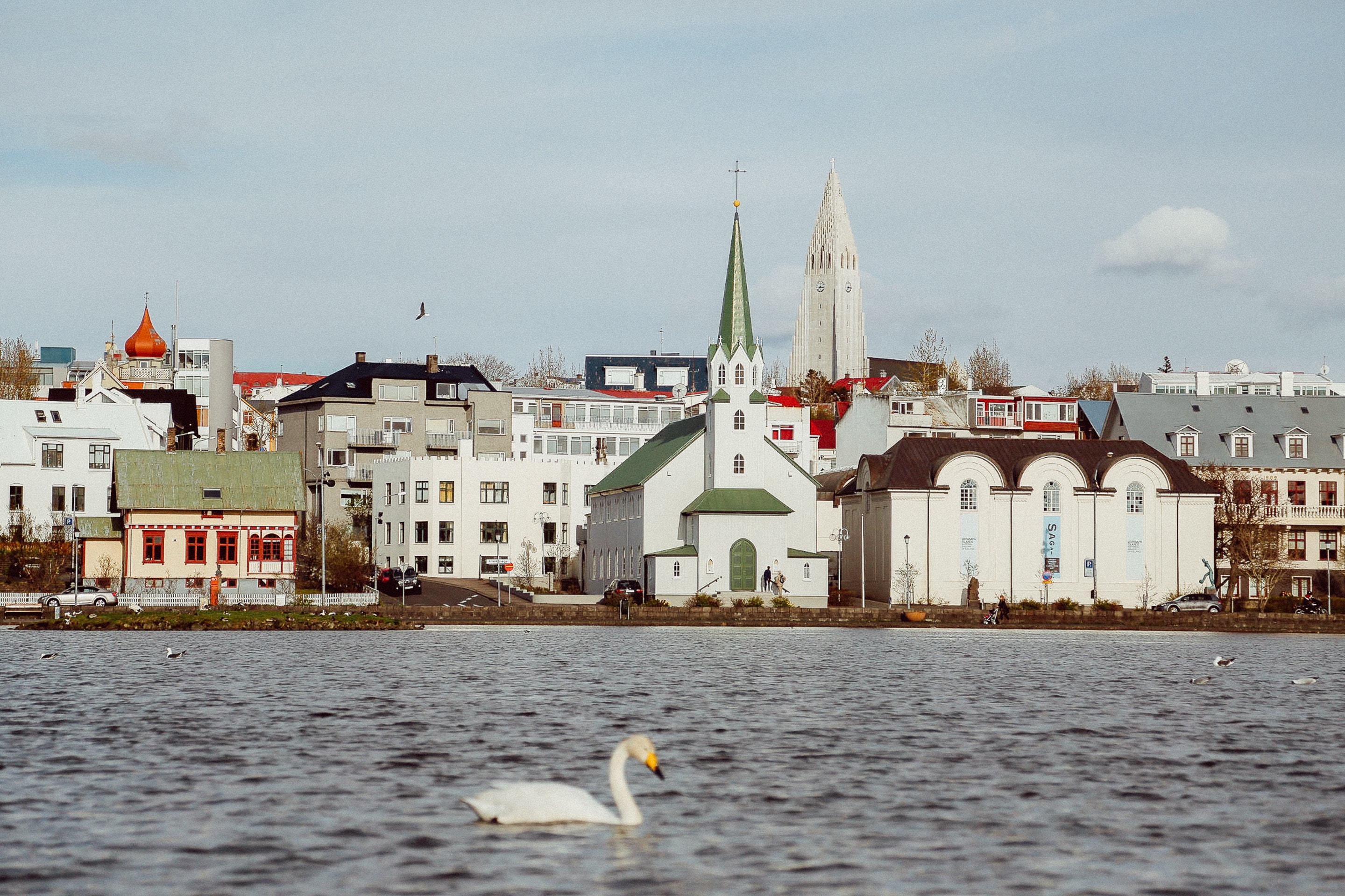
Sprawling Reykjavík, the nation's nerve center and government seat, is home to half the island's population. On a bay overlooked by proud Mt. Esja (pronounced eh-shyuh), with its ever-changing hues, Reykjavík presents a colorful sight, its concrete houses painted in light colors and topped by vibrant red, blue, and green roofs. In contrast to the almost treeless countryside, Reykjavík has many tall, native birches, rowans, and willows, as well as imported aspen, pines, and spruces.Reykjavík's name comes from the Icelandic words for smoke, reykur, and bay, vík. In AD 874, Norseman Ingólfur Arnarson saw Iceland rising out of the misty sea and came ashore at a bay eerily shrouded with plumes of steam from nearby hot springs. Today most of the houses in Reykjavík are heated by near-boiling water from the hot springs. Natural heating avoids air pollution; there's no smoke around. You may notice, however, that the hot water brings a slight sulfur smell to the bathroom.Prices are easily on a par with other major European cities. A practical option is to purchase a Reykjavík City Card at the Tourist Information Center or at the Reykjavík Youth Hostel. This card permits unlimited bus usage and admission to any of the city's seven pools, the Family Park and Zoo, and city museums. The cards are valid for one (ISK 3,300), two (ISK 4,400), or three days (ISK 4,900), and they pay for themselves after three or four uses a day. Even lacking the City Card, paying admission (ISK 500, or ISK 250 for seniors and people with disabilities) to one of the city art museums (Hafnarhús, Kjarvalsstaðir, or Ásmundarsafn) gets you free same-day admission to the other two.

About Reykjavík
Sprawling Reykjavík, the nation's nerve center and government seat, is home to half the island's population. On a bay overlooked by proud Mt. Esja (pronounced eh-shyuh), with its ever-changing hues, Reykjavík presents a colorful sight, its concrete houses painted in light colors and topped by vibrant red, blue, and green roofs. In contrast to the almost treeless countryside, Reykjavík has many tall, native birches, rowans, and willows, as well as imported aspen, pines, and spruces.Reykjavík's name comes from the Icelandic words for smoke, reykur, and bay, vík. In AD 874, Norseman Ingólfur Arnarson saw Iceland rising out of the misty sea and came ashore at a bay eerily shrouded with plumes of steam from nearby hot springs. Today most of the houses in Reykjavík are heated by near-boiling water from the hot springs. Natural heating avoids air pollution; there's no smoke around. You may notice, however, that the hot water brings a slight sulfur smell to the bathroom.Prices are easily on a par with other major European cities. A practical option is to purchase a Reykjavík City Card at the Tourist Information Center or at the Reykjavík Youth Hostel. This card permits unlimited bus usage and admission to any of the city's seven pools, the Family Park and Zoo, and city museums. The cards are valid for one (ISK 3,300), two (ISK 4,400), or three days (ISK 4,900), and they pay for themselves after three or four uses a day. Even lacking the City Card, paying admission (ISK 500, or ISK 250 for seniors and people with disabilities) to one of the city art museums (Hafnarhús, Kjarvalsstaðir, or Ásmundarsafn) gets you free same-day admission to the other two.
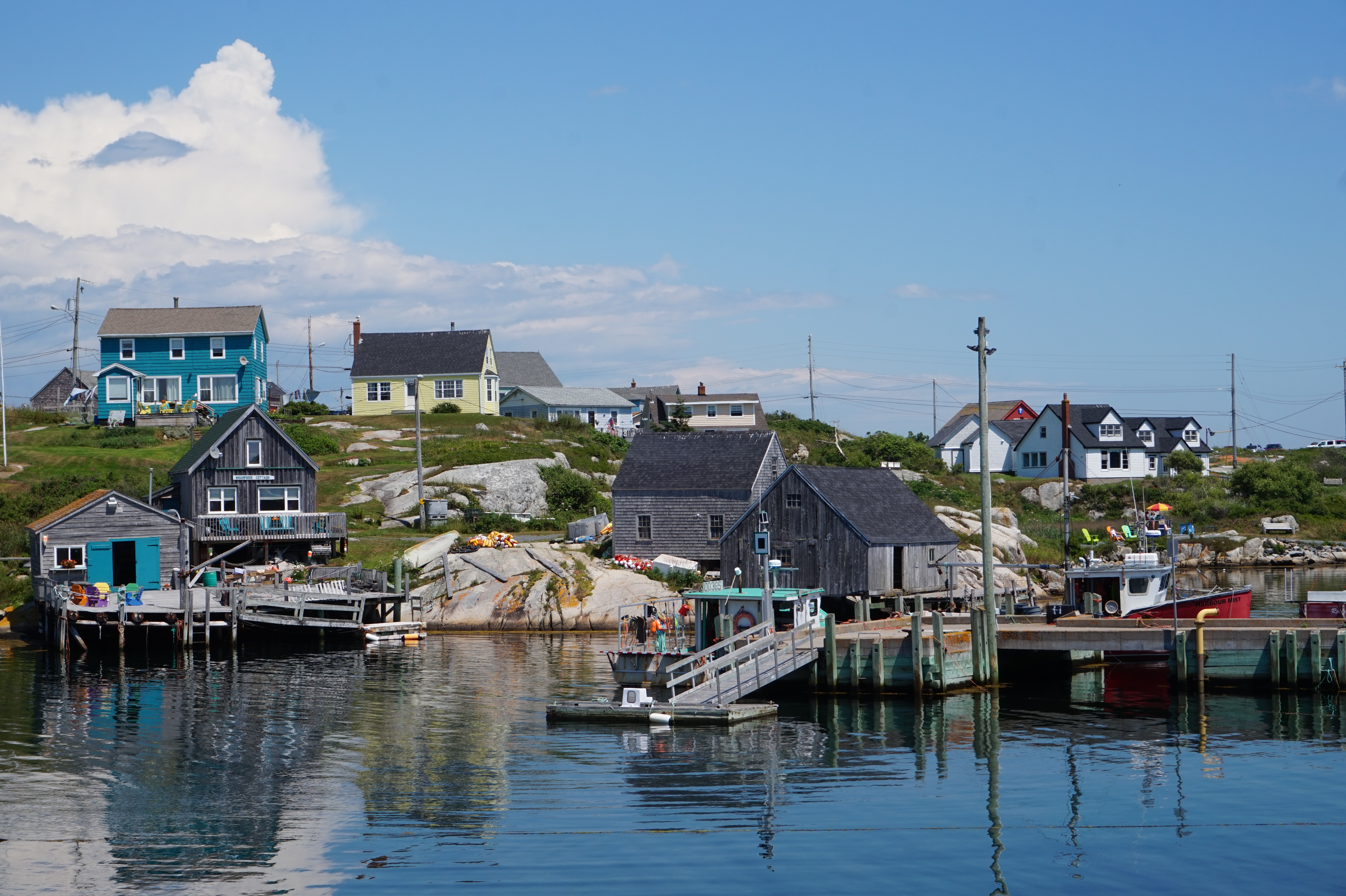
About Grundarfjørdur

About Paamiut (Fredrikshaab)

About Nuuk (Godthaab)
Nuuk, meaning “the cape”, was Greenland’s first town (1728). Started as a fort and later mission and trading post some 240 kilometers south of the Arctic Circle, it is the current capital. Almost 30% of Greenland’s population lives in the town. Not only does Nuuk have great natural beauty in its vicinity, but there are Inuit ruins, Hans Egede’s home, the parliament, and the Church of our Saviour as well. The Greenlandic National Museum has an outstanding collection of Greenlandic traditional dresses, as well as the famous Qilakitsoq mummies. The Katuaq Cultural Center’s building was inspired by the undulating Northern Lights and can house 10% of Nuuk’s inhabitants.


About Corner Brook, Newfoundland and Labrador
Newfoundland's fourth-largest city, Corner Brook is the hub of the island's west coast. Hills fringe three sides of the city, which has dramatic views of the harbor and the Bay of Islands. The town is also home to a large paper mill and a branch of Memorial University. Captain James Cook, the British explorer, charted the coast in the 1760s, and a memorial to him overlooks the bay.The town enjoys more clearly defined seasons than most of the rest of the island, and in summer it has many pretty gardens. The nearby Humber River is the best-known salmon river in the province, and there are many kilometers of well-maintained walking trails in the community.


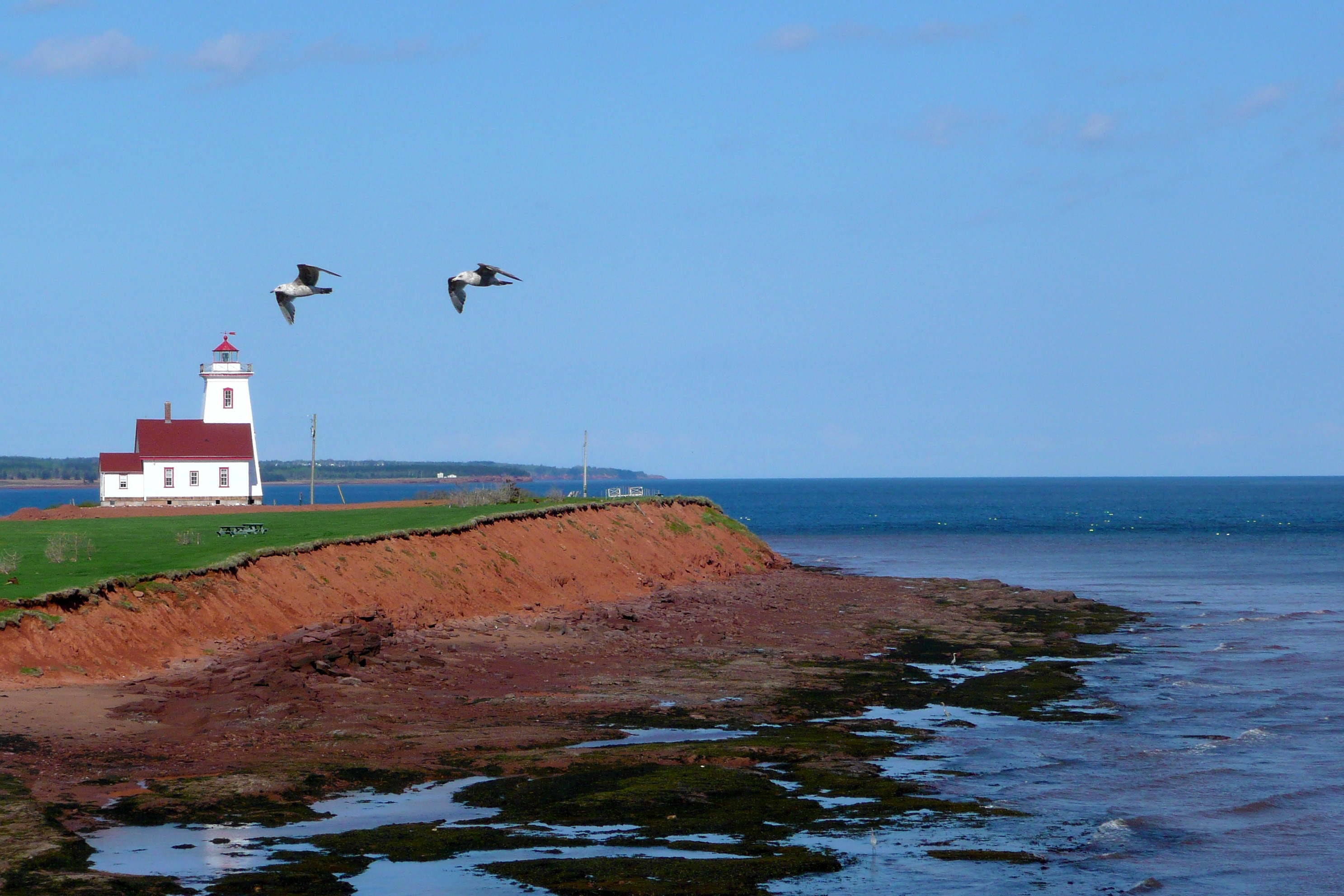
About Charlottetown, Prince Edward Island
Designated as the Island capital in 1765, Charlottetown is both PEI’s oldest and largest urban center. However, since the whole "metropolitan" area only has a population of about 65,000, a pleasing small-town atmosphere remains. The city is a winner appearance-wise as well. Peppered with gingerbread-clad homes, converted warehouses, striking churches, and monumental government buildings, Charlottetown’s core seems relatively unchanged from its 19th-century heyday when it hosted the conference that led to the formation of Canada. The city is understandably proud of its role as the "Birthplace of Confederation" and, in summer, downtown streets are dotted with people dressed as personages from the past who’ll regale you with tales about the Confederation debate.
About Sydney, Nova Scotia
If you come directly to Cape Breton via plane, ferry, or cruise ship, Sydney is where you’ll land. If you’re seeking anything resembling an urban experience, it’s also where you’ll want to stay: after all, this is the island’s sole city. Admittedly, it is not the booming center it was a century ago when the continent’s largest steel plant was located here (that era is evoked in Fall on Your Knees, an Oprah Book Club pick penned by Cape Bretoner Anne-Marie MacDonald). However, Sydney has a revitalized waterfront and smattering of Loyalist-era buildings that appeal to visitors. Moreover, it offers convenient access to popular attractions in the region—like the Miner’s Museum in nearby Glace Bay (named for the glace, or ice, that filled its harbor in winter), the Fortress at Louisbourg, and beautiful Bras d'Or Lake.

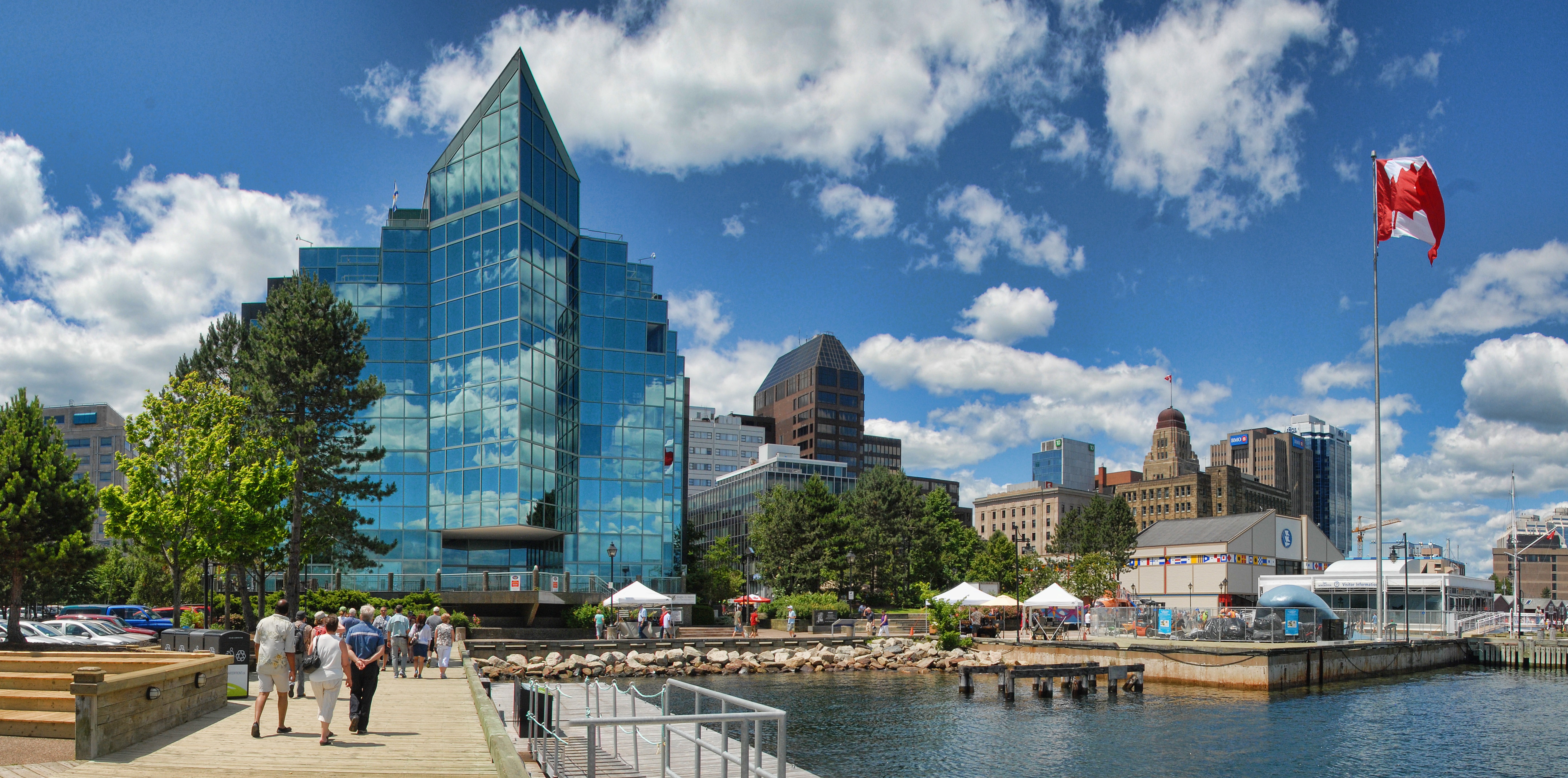
About Halifax, Nova Scotia
Surrounded by natural treasures and glorious seascapes, Halifax is an attractive and vibrant hub with noteworthy historic and modern architecture, great dining and shopping, and a lively nightlife and festival scene. The old city manages to feel both hip and historic. Previous generations had the foresight to preserve the cultural and architectural integrity of the city, yet students from five local universities keep it lively and current. It's a perfect starting point to any tour of the Atlantic provinces, but even if you don't venture beyond its boundaries, you will get a real taste of the region.It was Halifax’s natural harbor—the second largest in the world after Sydney, Australia’s—that first drew the British here in 1749, and today most major sites are conveniently located either along it or on the Citadel-crowned hill overlooking it. That’s good news for visitors because this city actually covers quite a bit of ground.Since amalgamating with Dartmouth (directly across the harbor) and several suburbs in 1996, Halifax has been absorbed into the Halifax Regional Municipality, and the HRM, as it is known, has around 415,000 residents. That may not sound like a lot by U.S. standards, but it makes Nova Scotia’s capital the most significant Canadian urban center east of Montréal.There's easy access to the water, and despite being the focal point of a busy commercial port, Halifax Harbour doubles as a playground, with one of the world's longest downtown boardwalks. It's a place where container ships, commuter ferries, cruise ships, and tour boats compete for space, and where workaday tugs and fishing vessels tie up beside glitzy yachts. Like Halifax as a whole, the harbor represents a blend of the traditional and the contemporary.
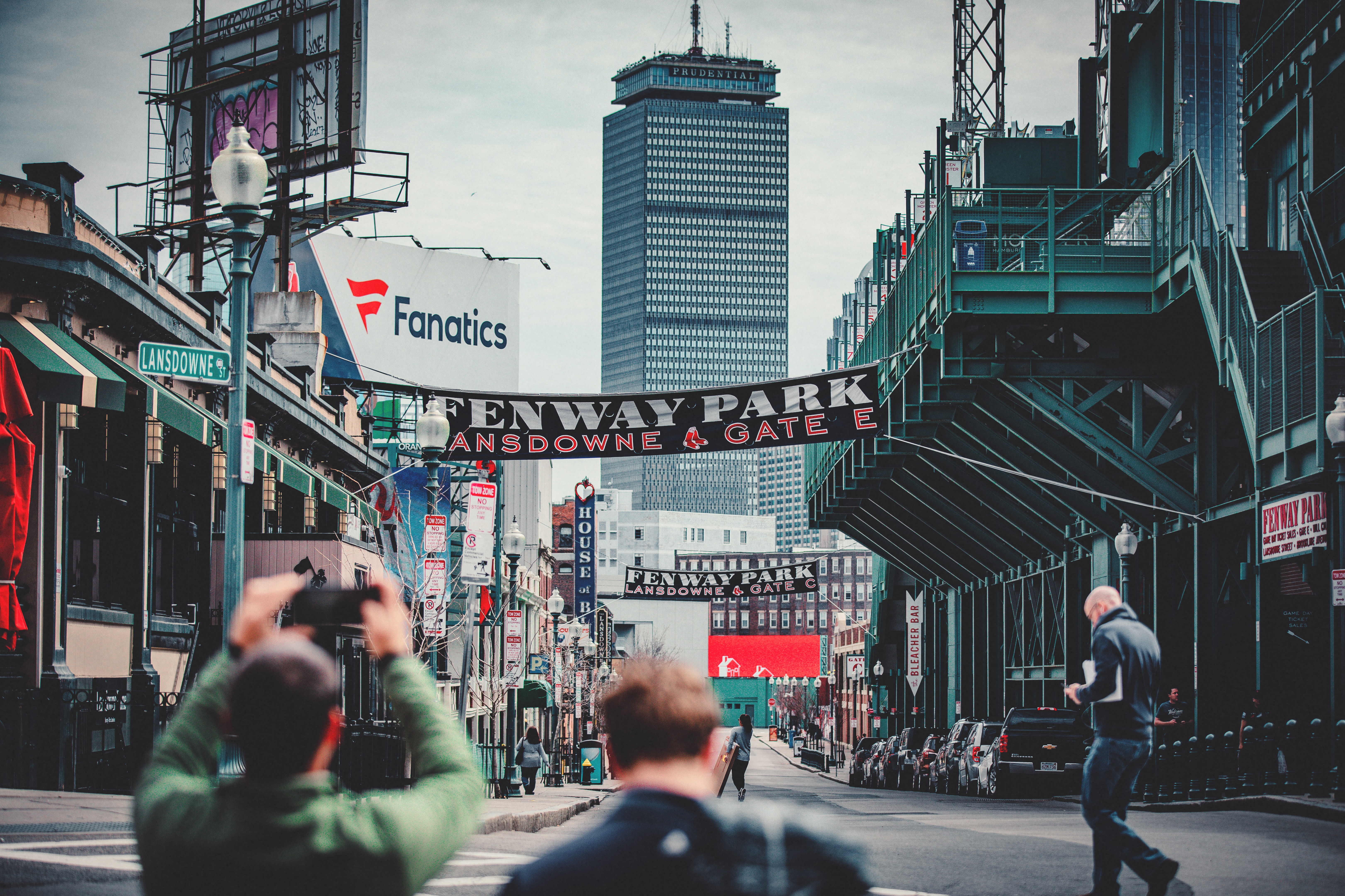
About Boston, Massachusetts
There’s history and culture around every bend in Boston—skyscrapers nestle next to historic hotels while modern marketplaces line the antique cobblestone streets. But to Bostonians, living in a city that blends yesterday and today is just another day in beloved Beantown.


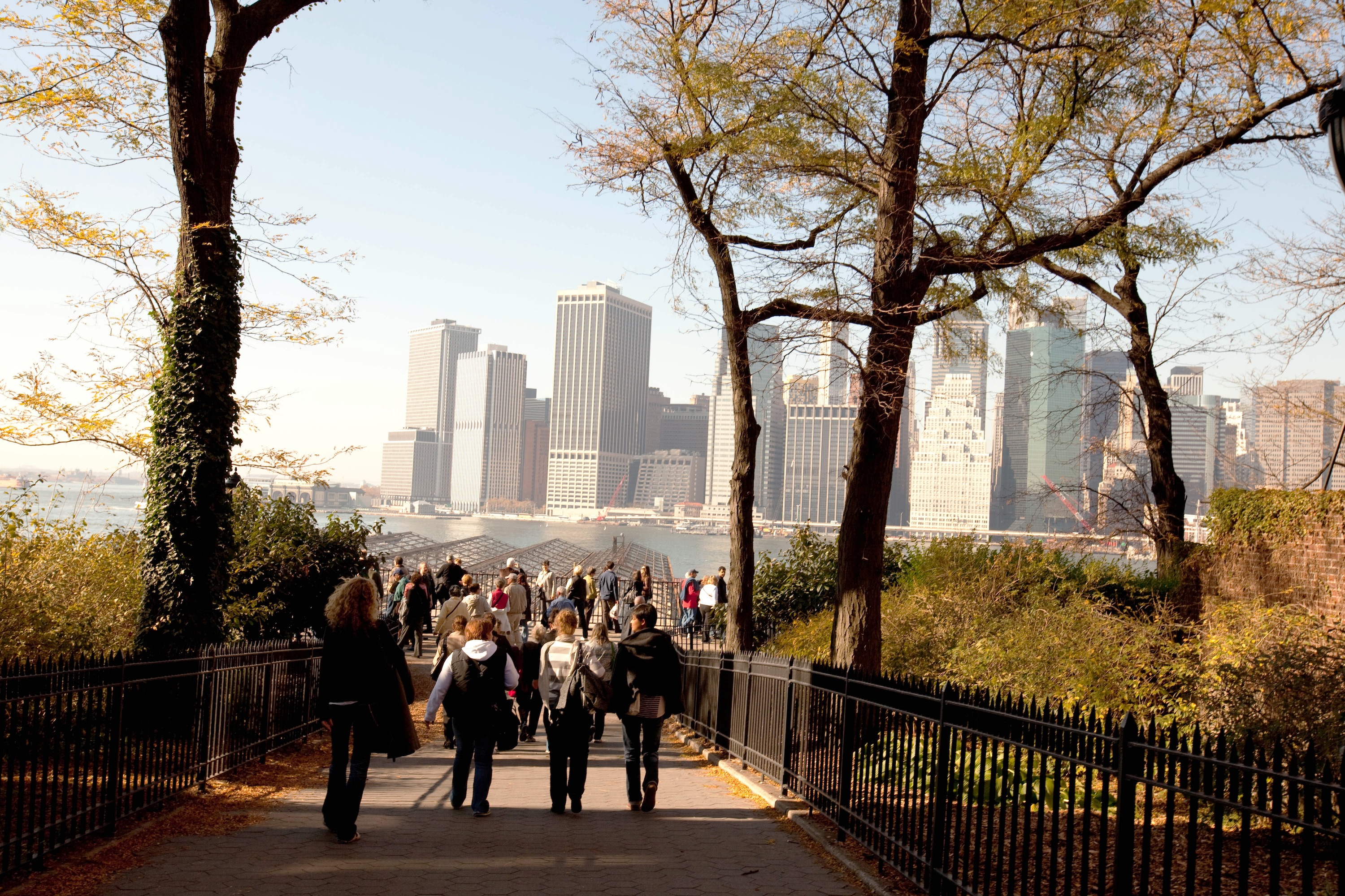
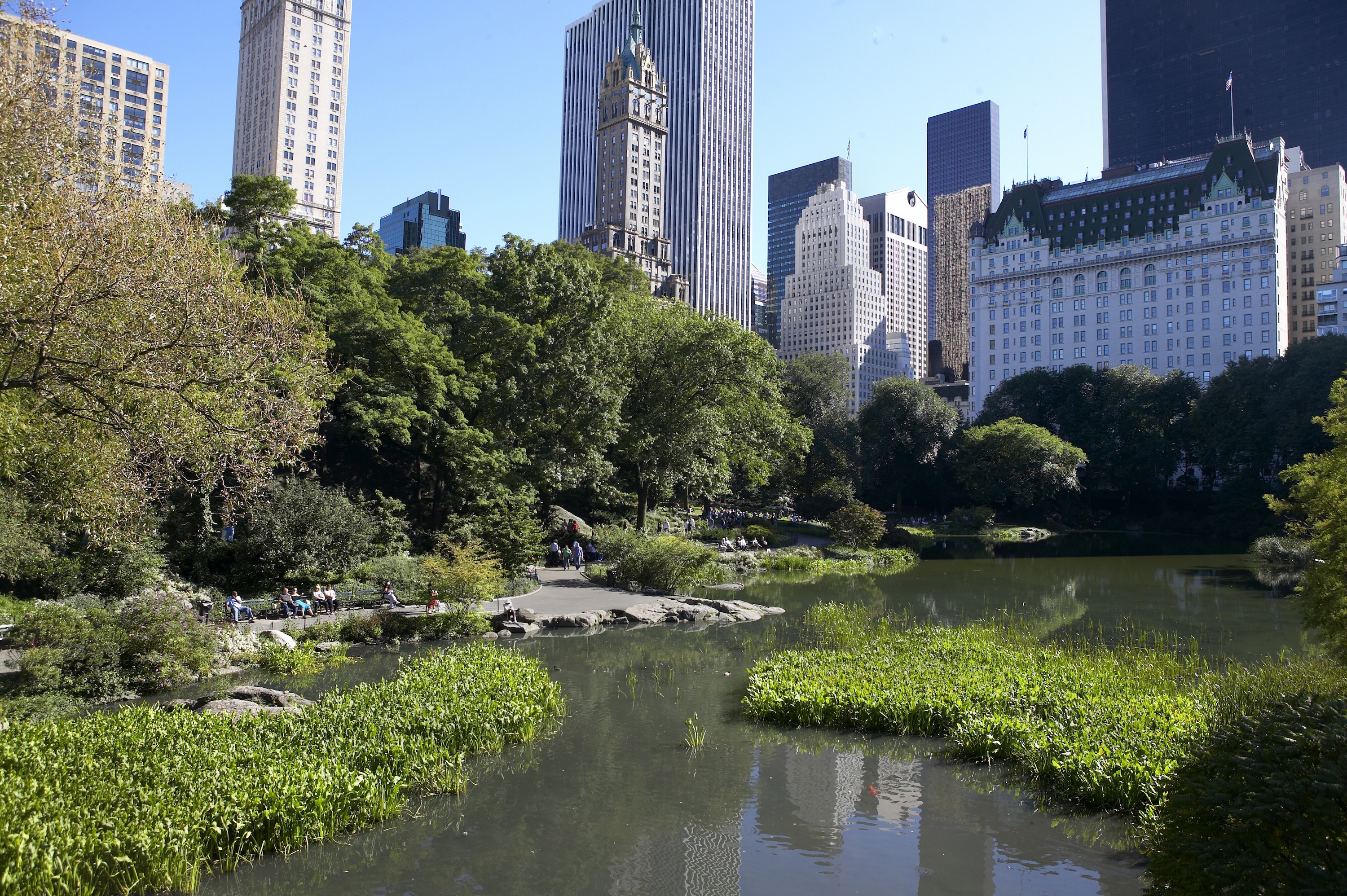
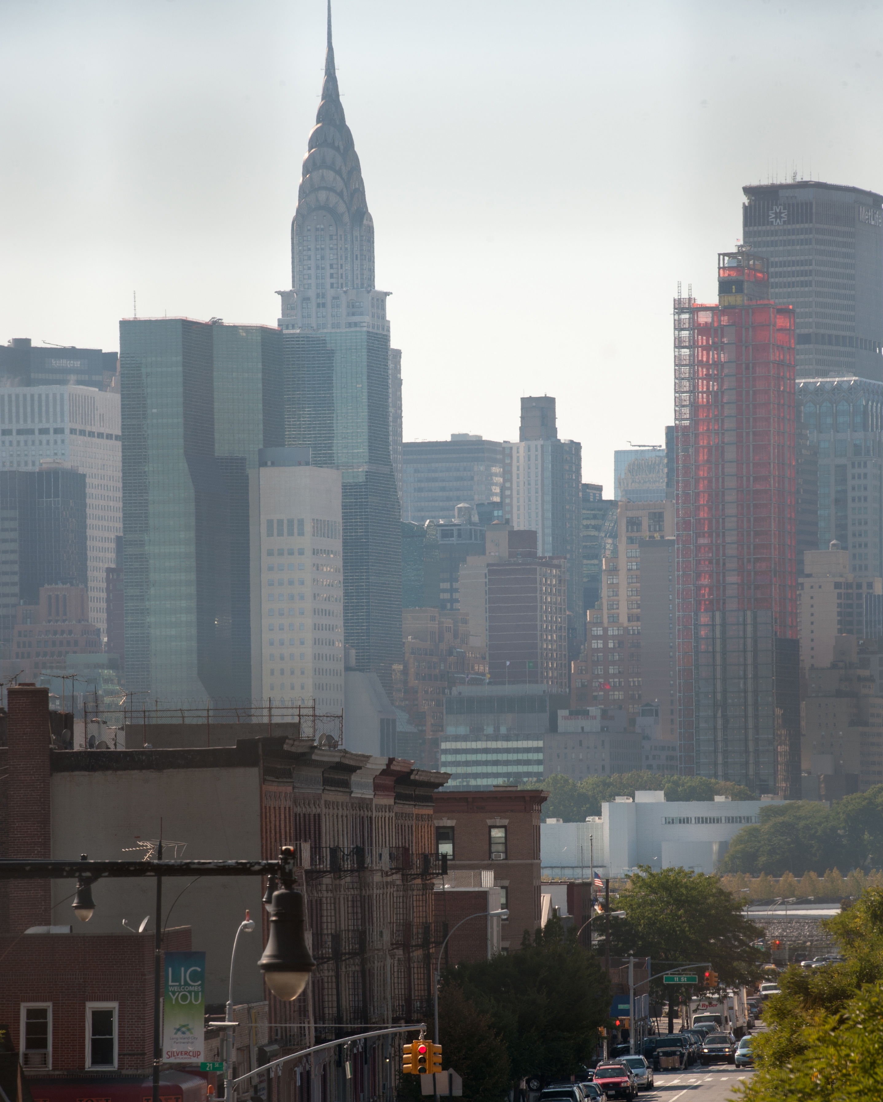
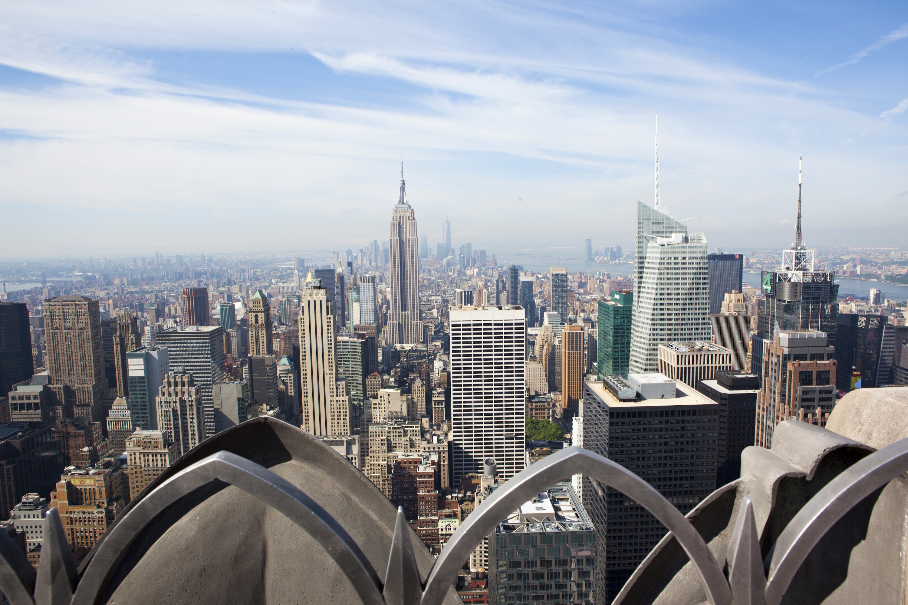
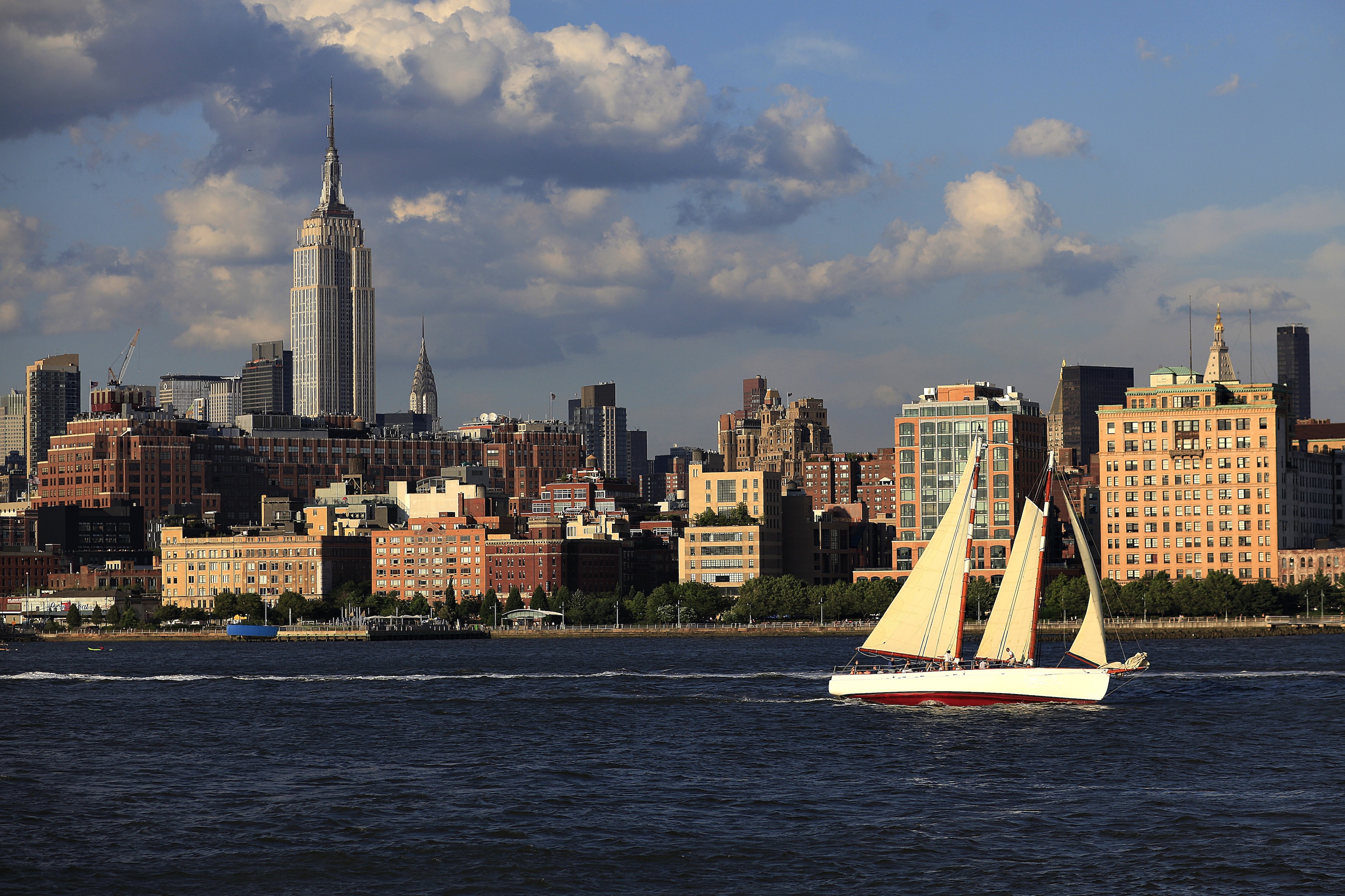
About New York, New York
From Wall Street's skyscrapers to the neon of Times Square to Central Park's leafy paths, New York City pulses with an irrepressible energy. History meets hipness in this global center of entertainment, fashion, media, and finance. World-class museums like MoMA and unforgettable icons like the Statue of Liberty beckon, but discovering the subtler strains of New York's vast ambition is equally rewarding: ethnic enclaves and shops, historic streets of dignified brownstones, and trendy bars and eateries all add to the urban buzz.


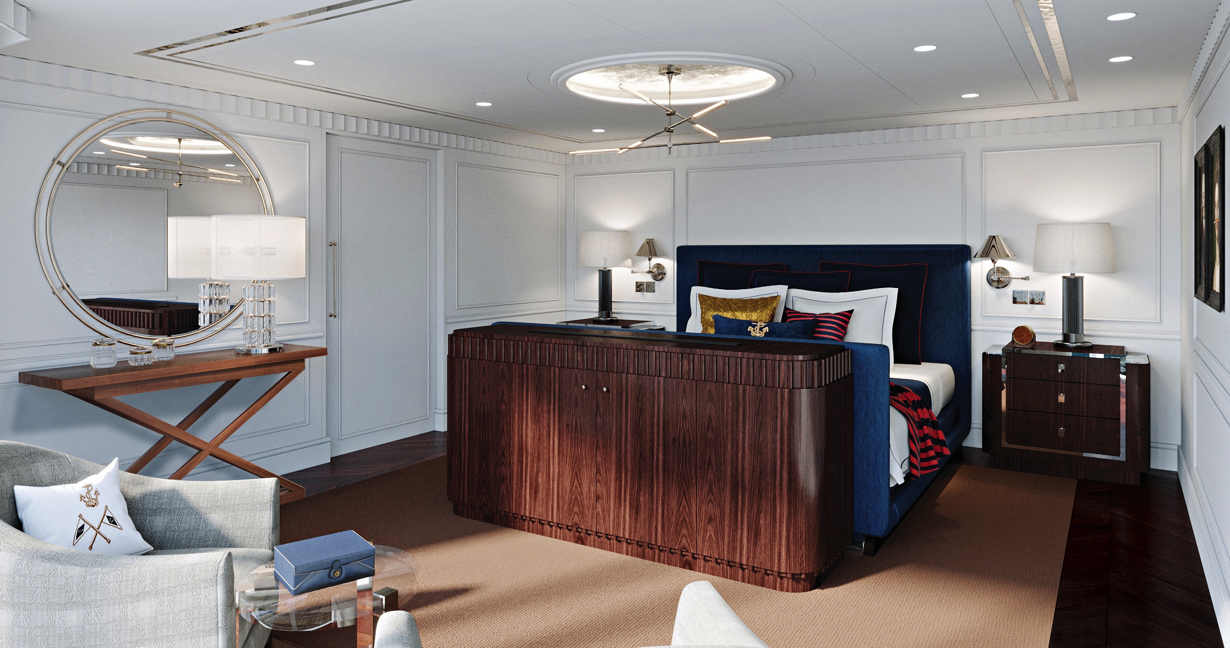
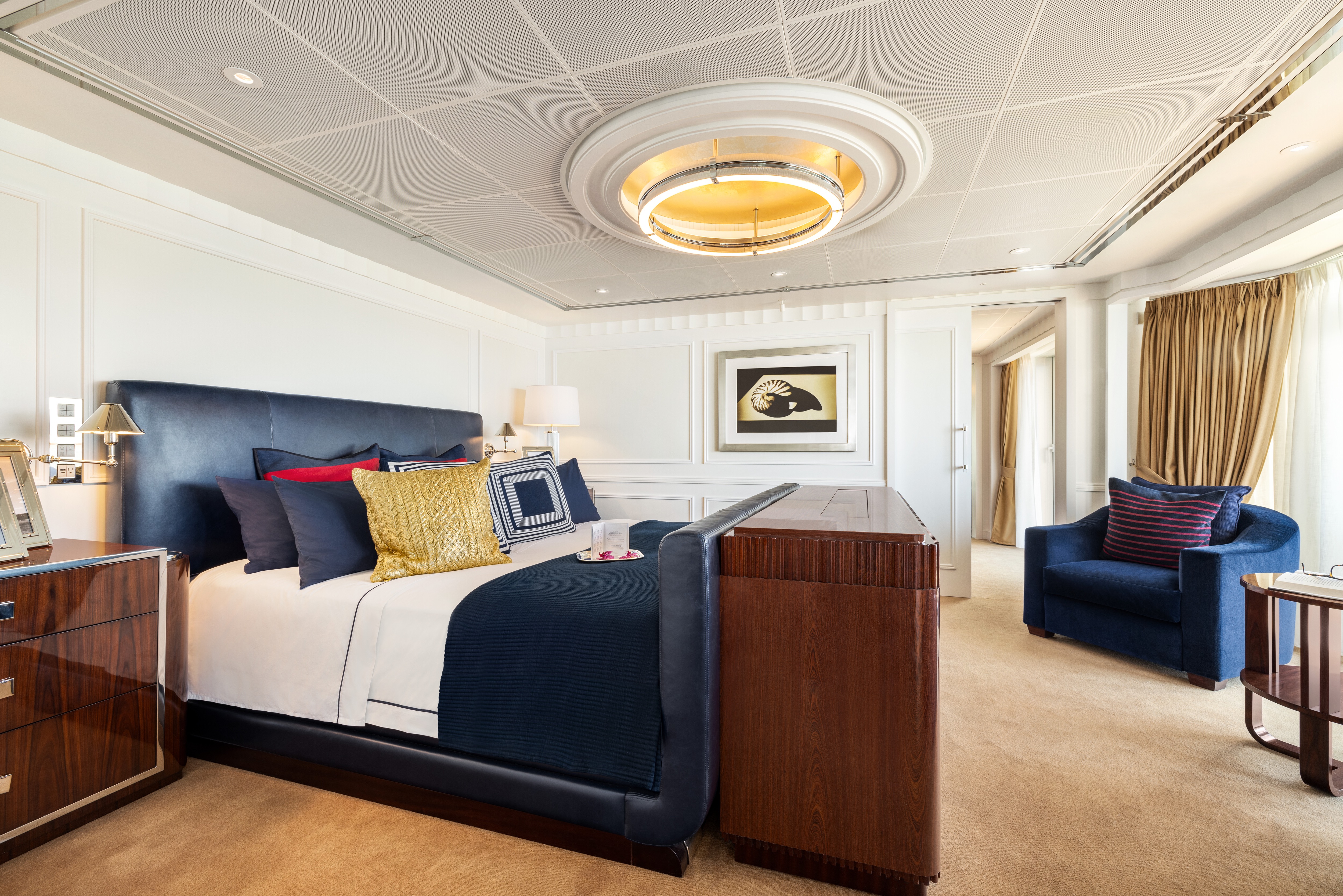
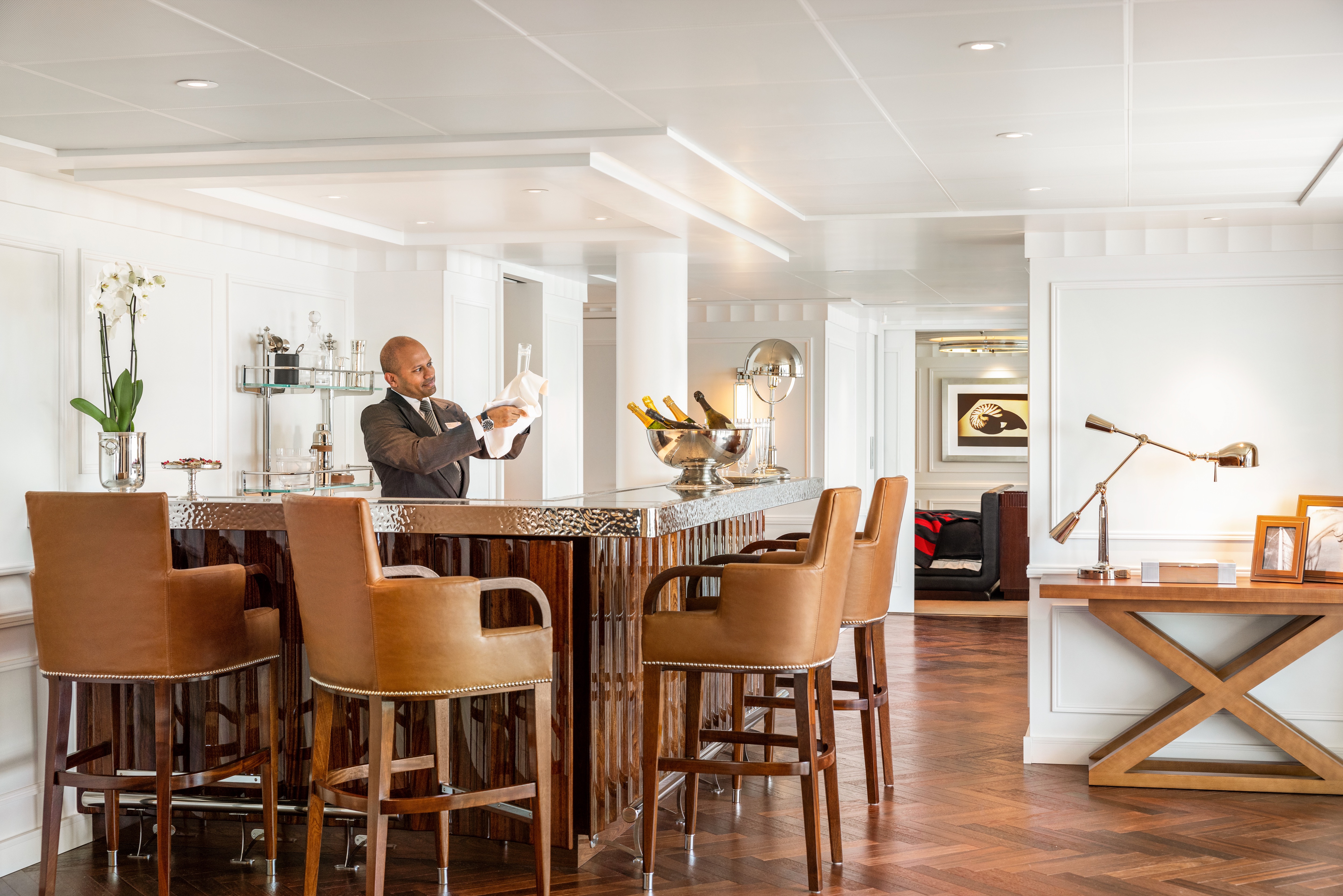
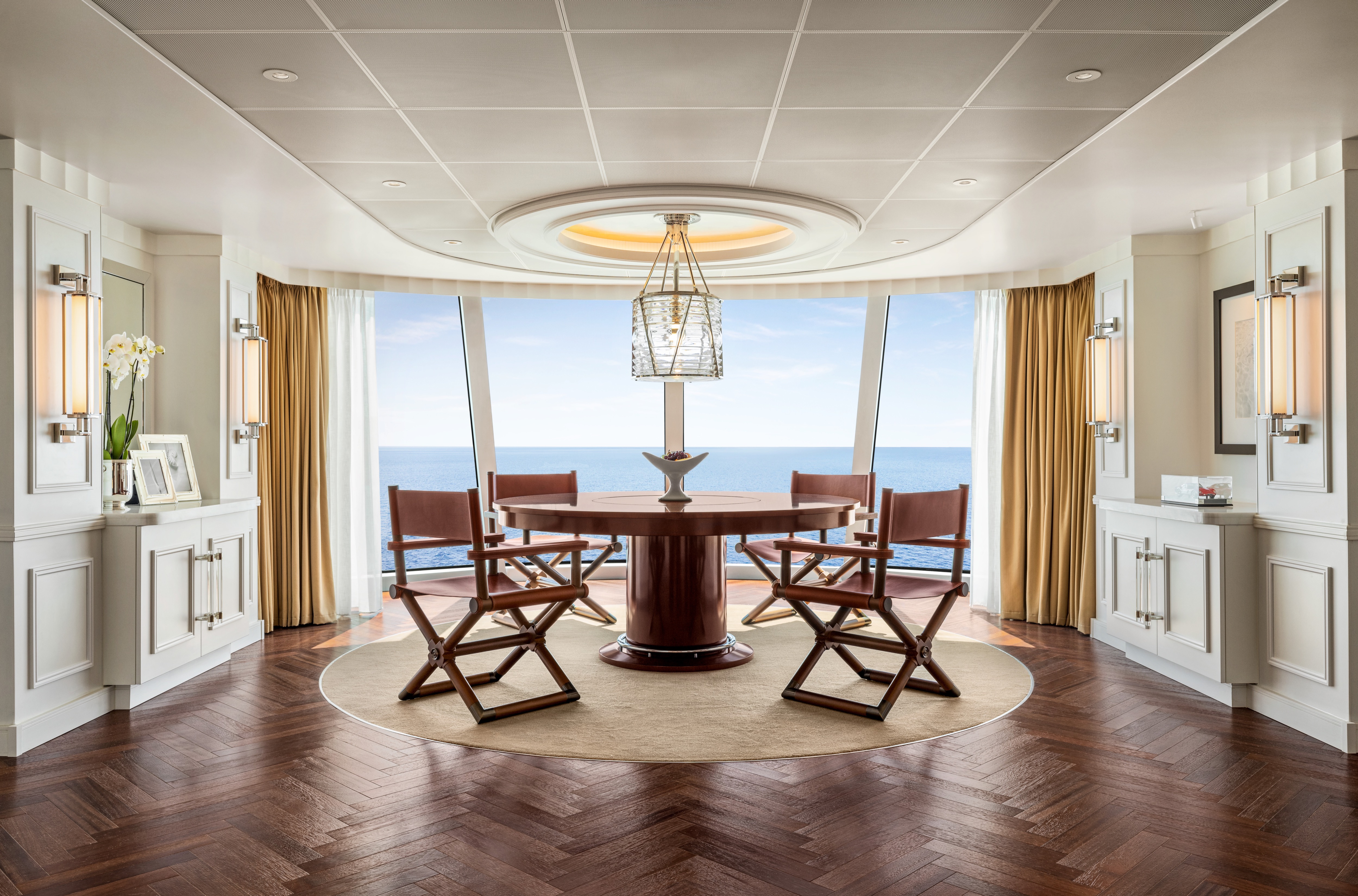
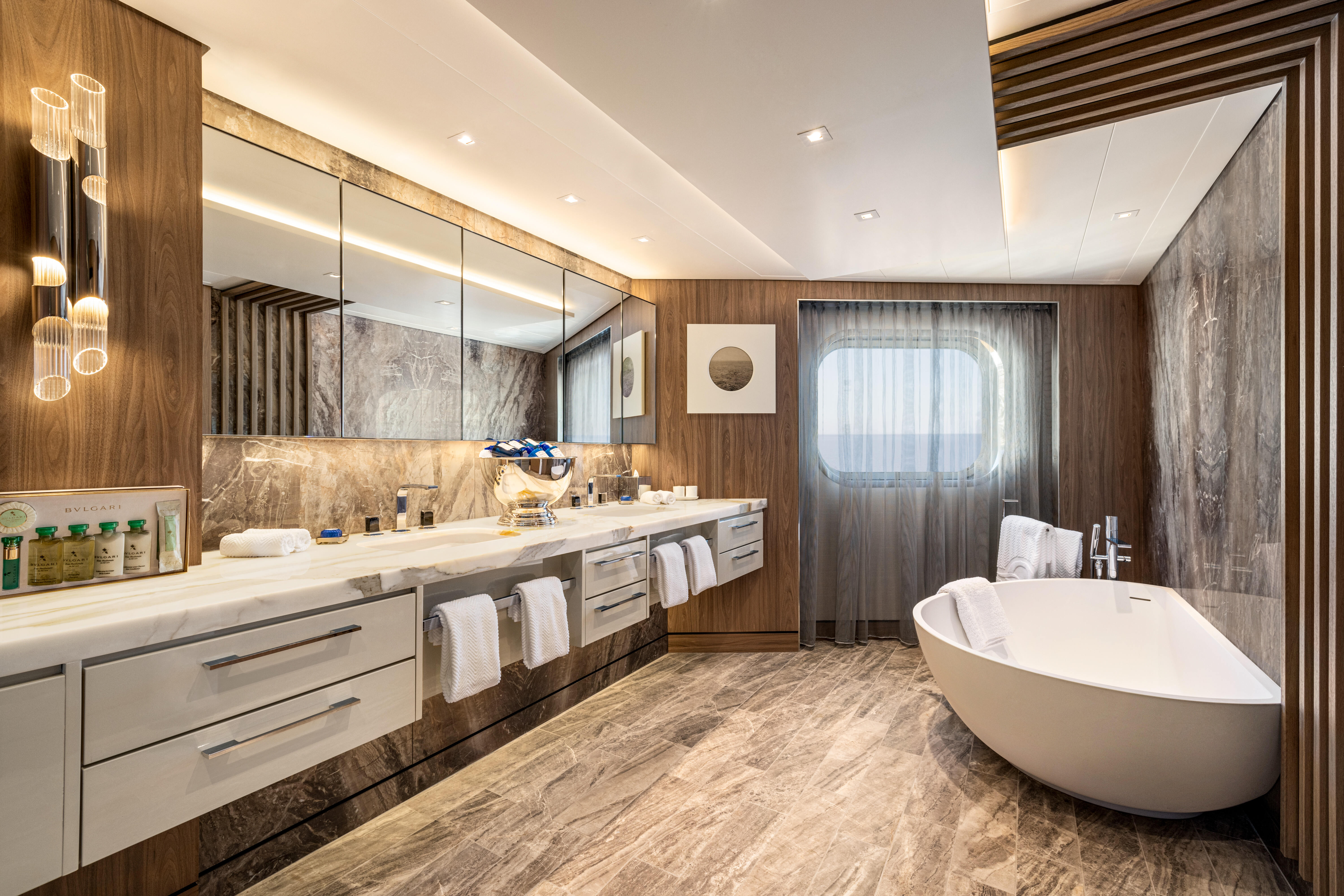
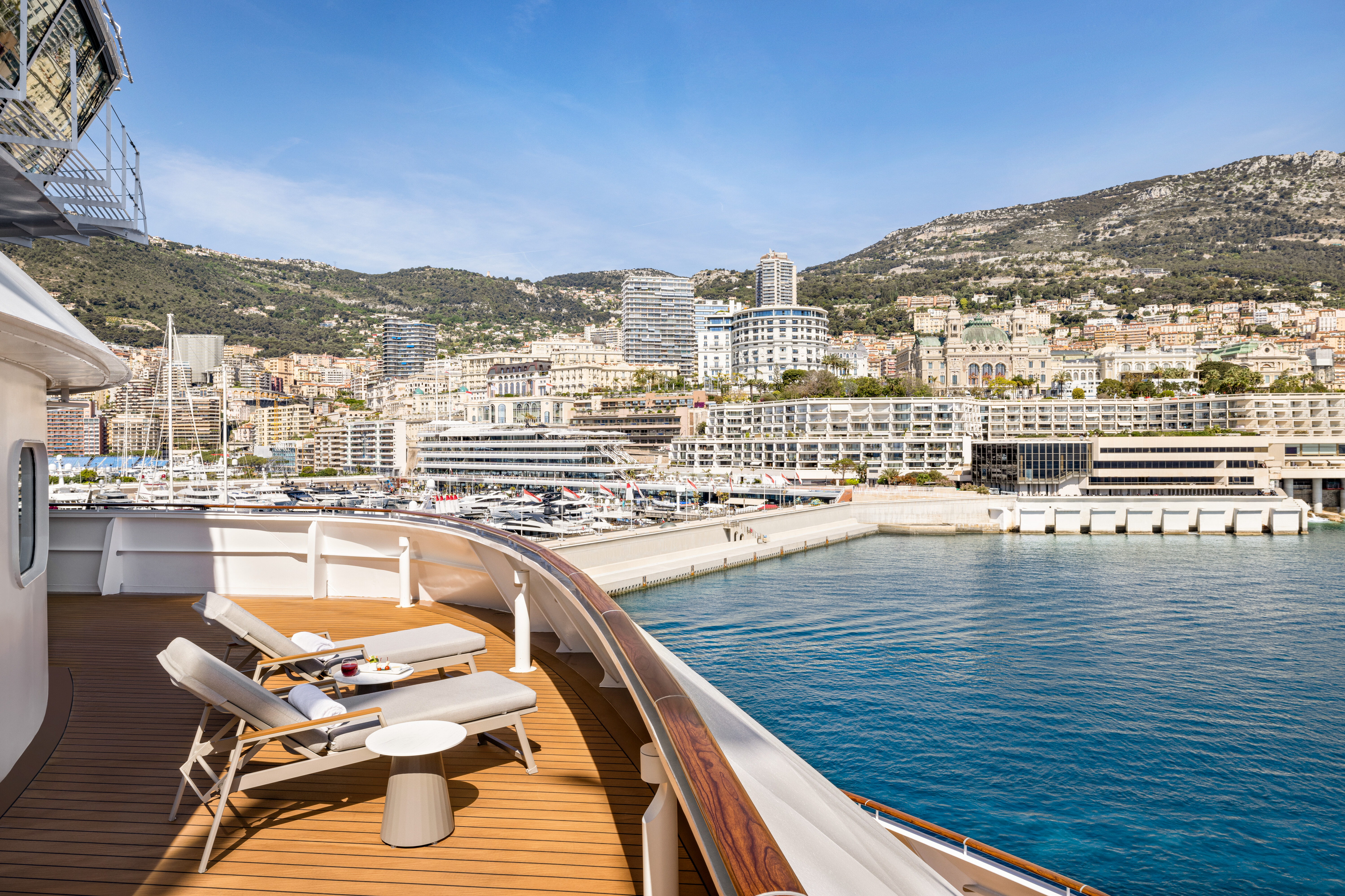
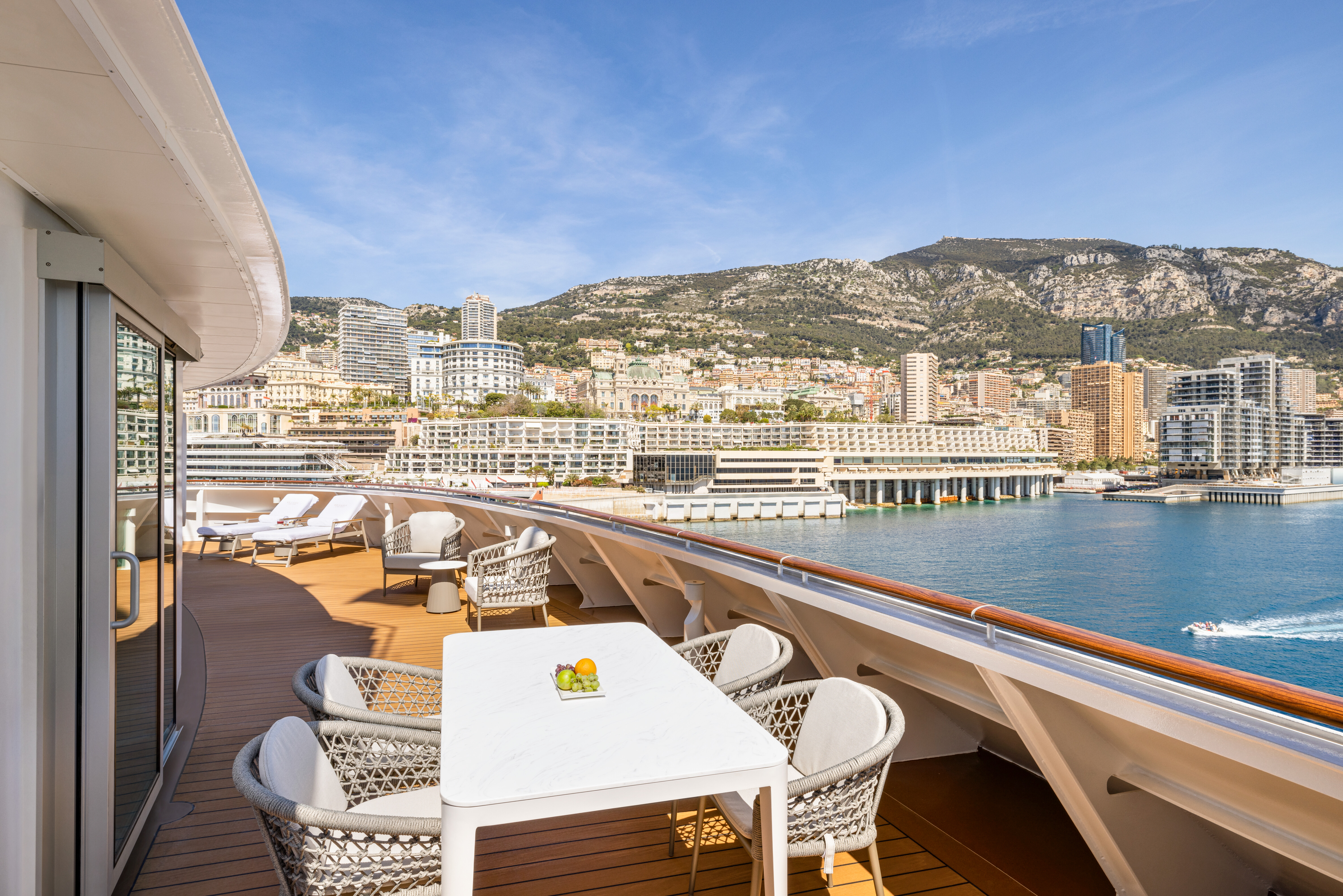
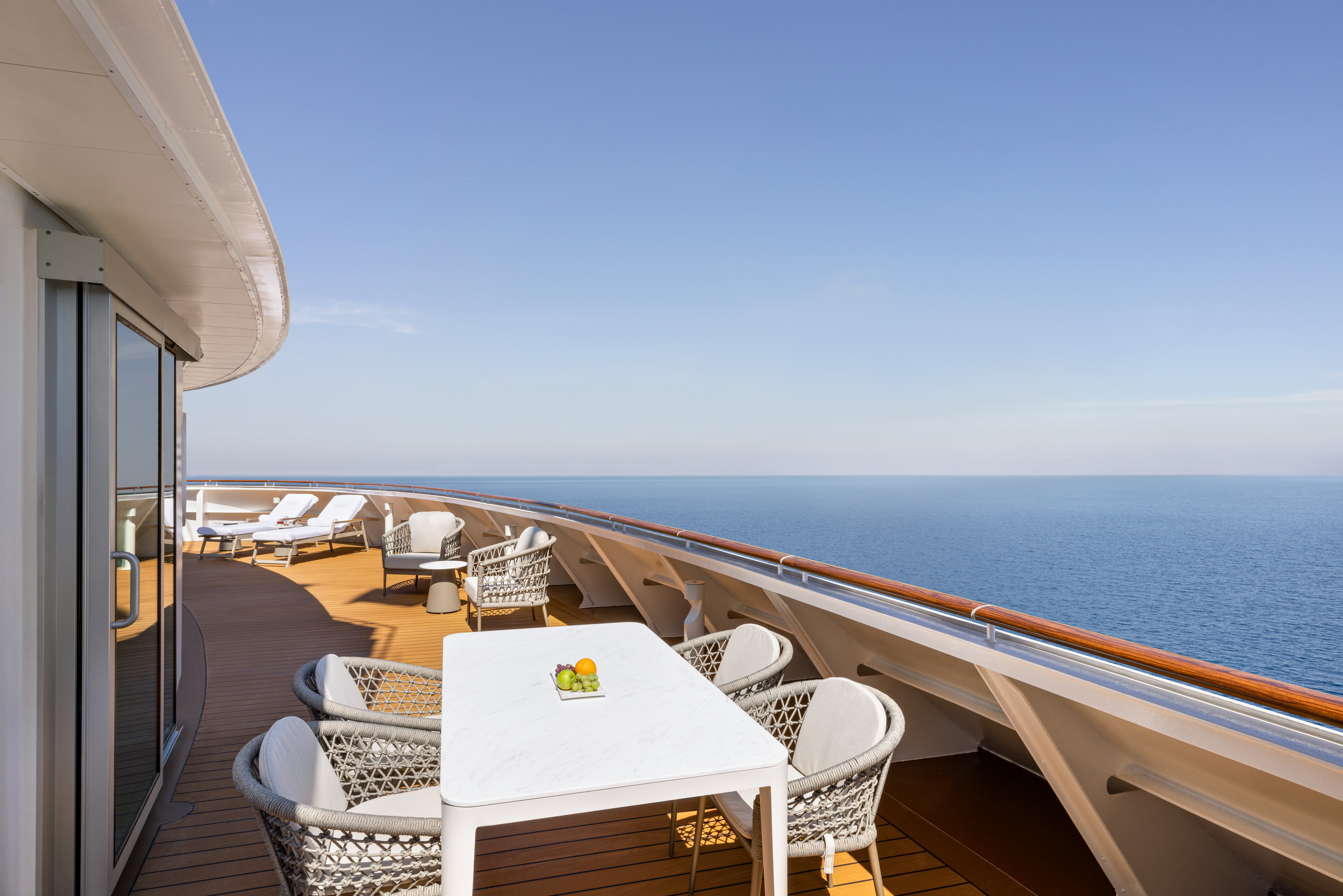
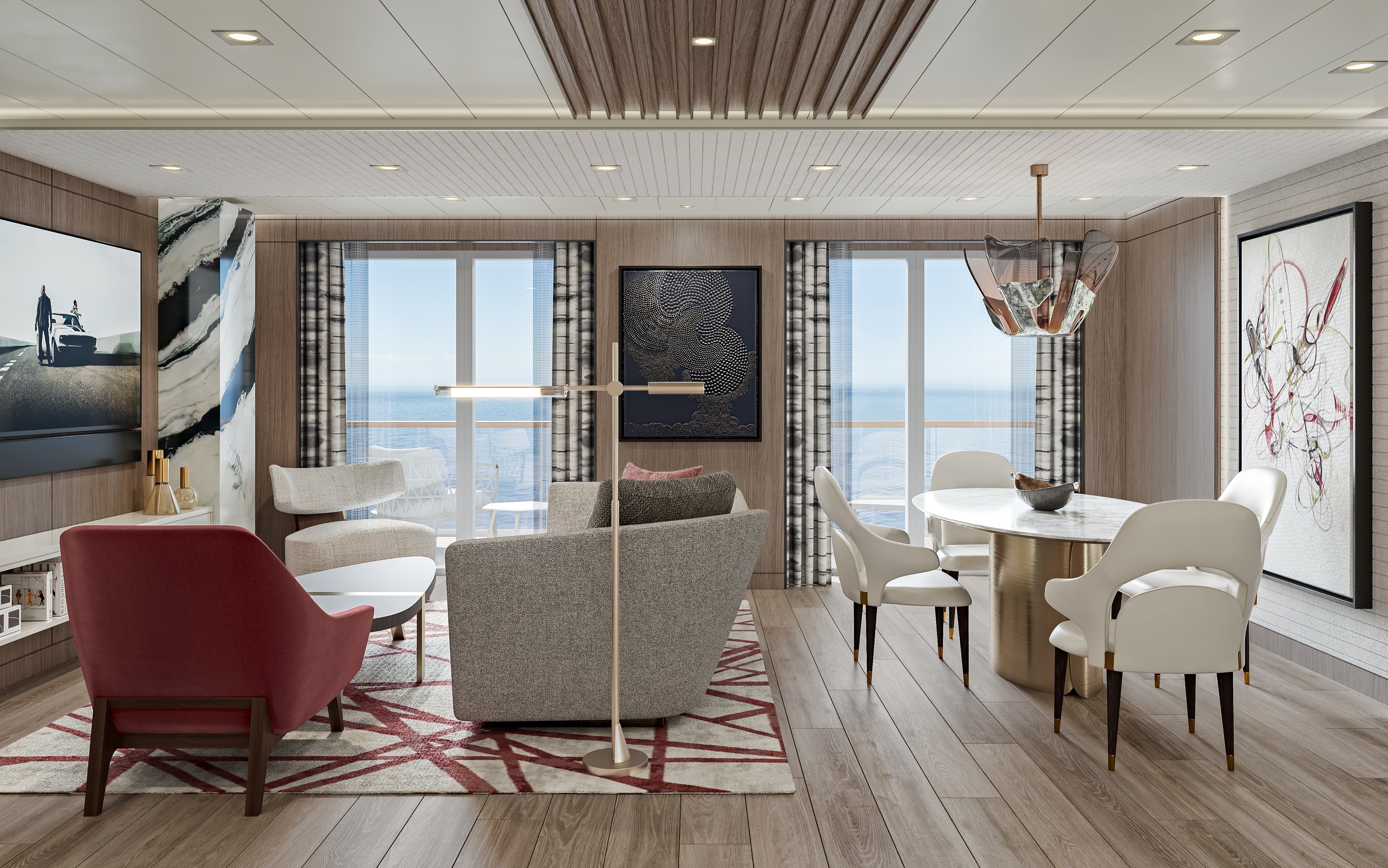
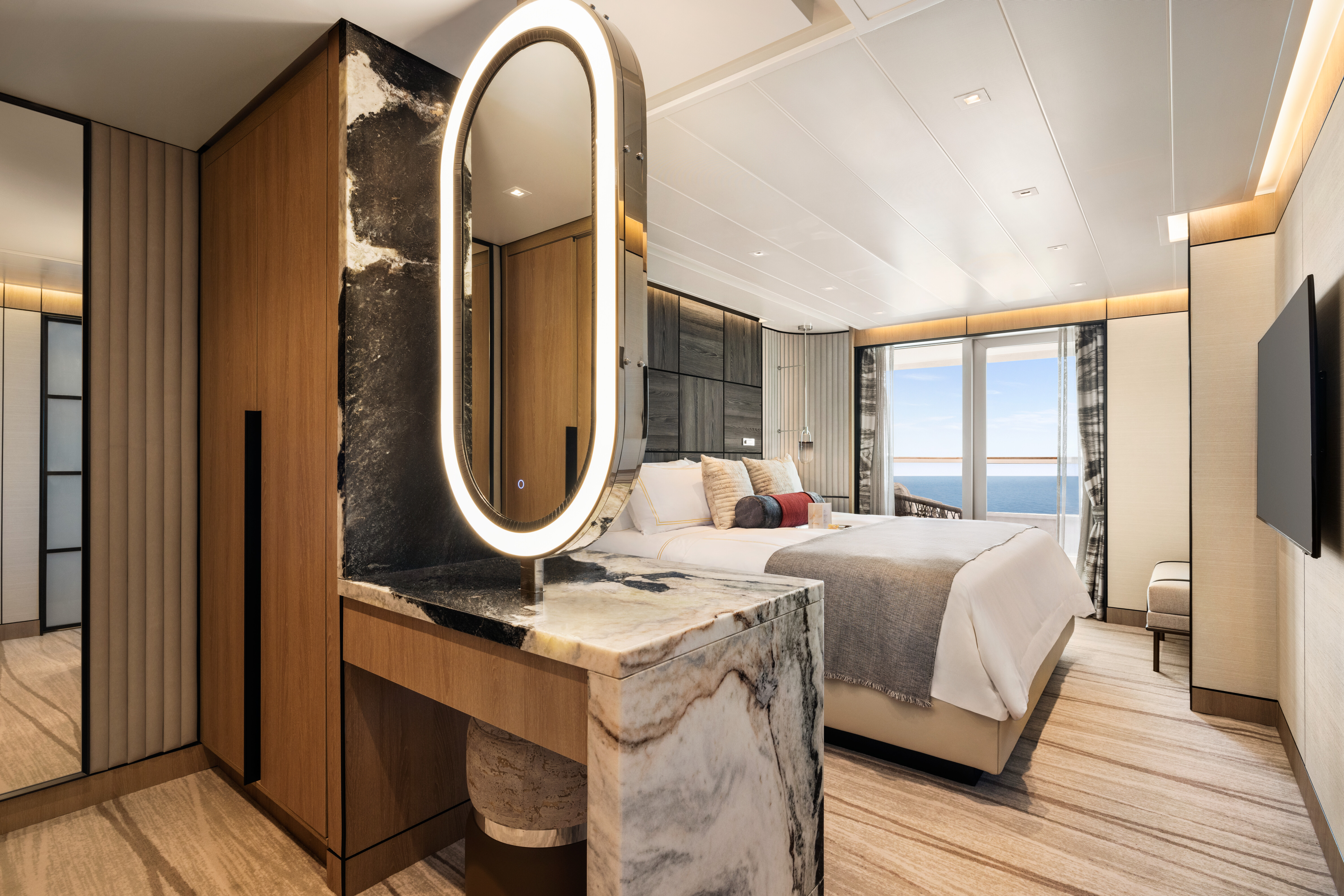
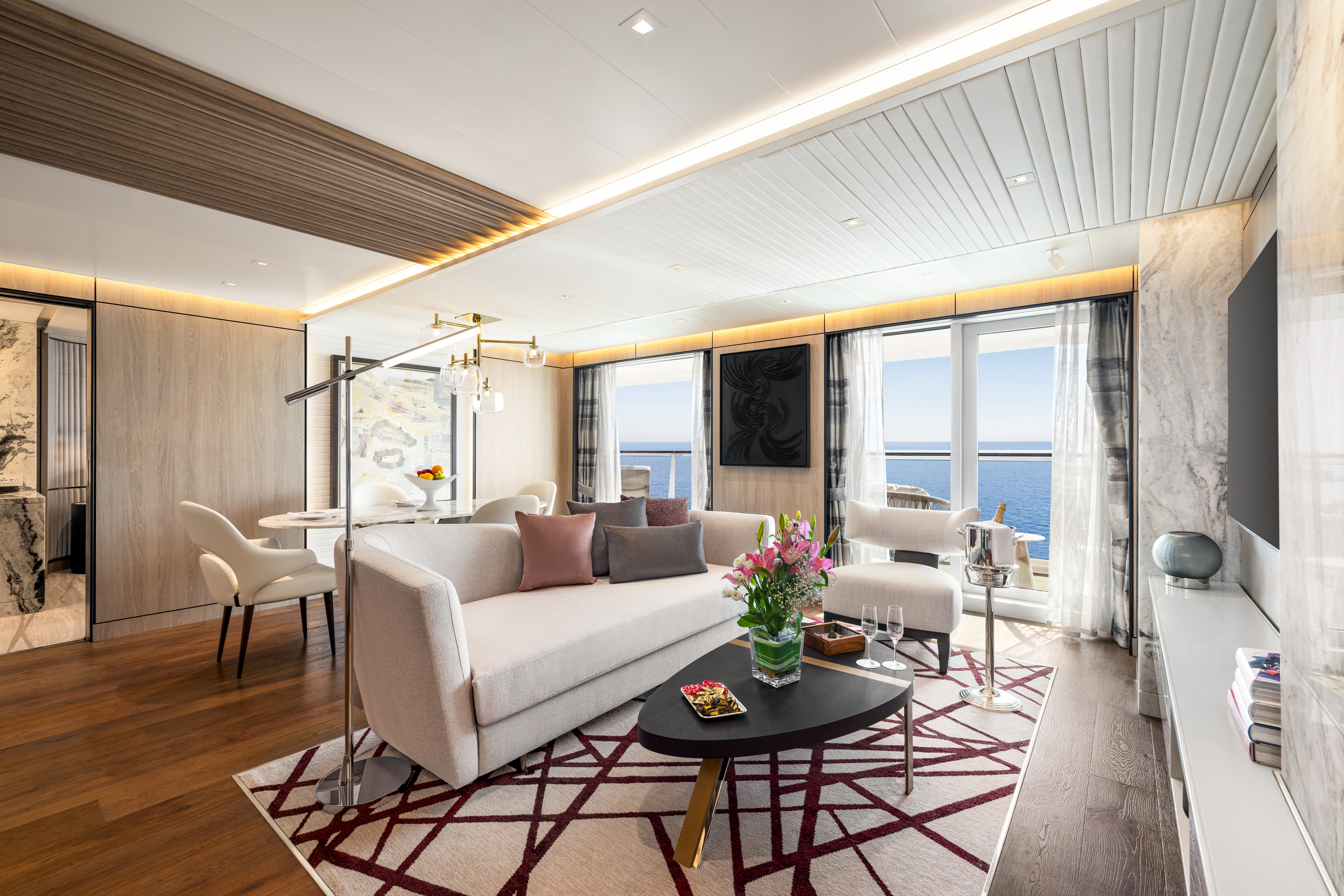
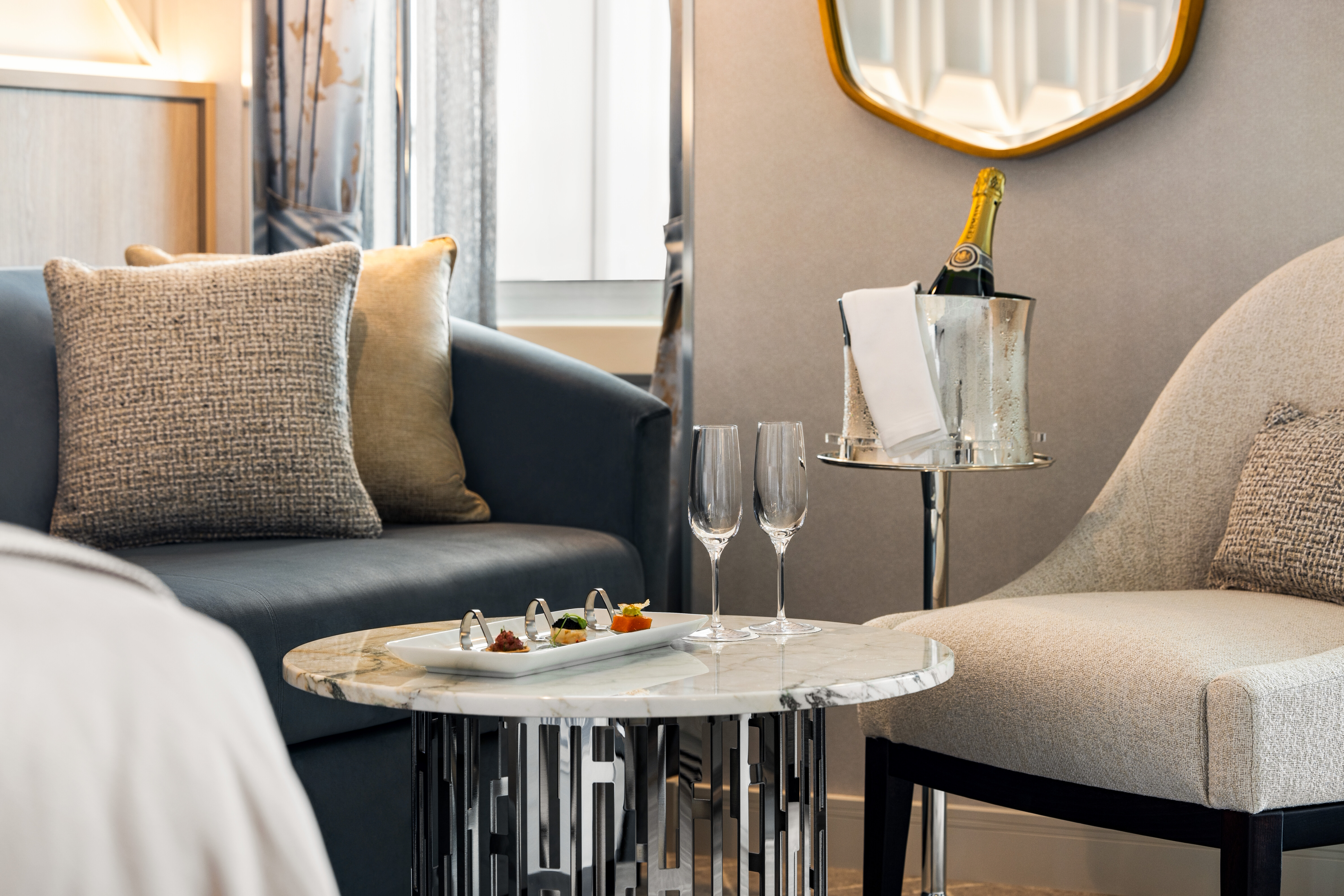
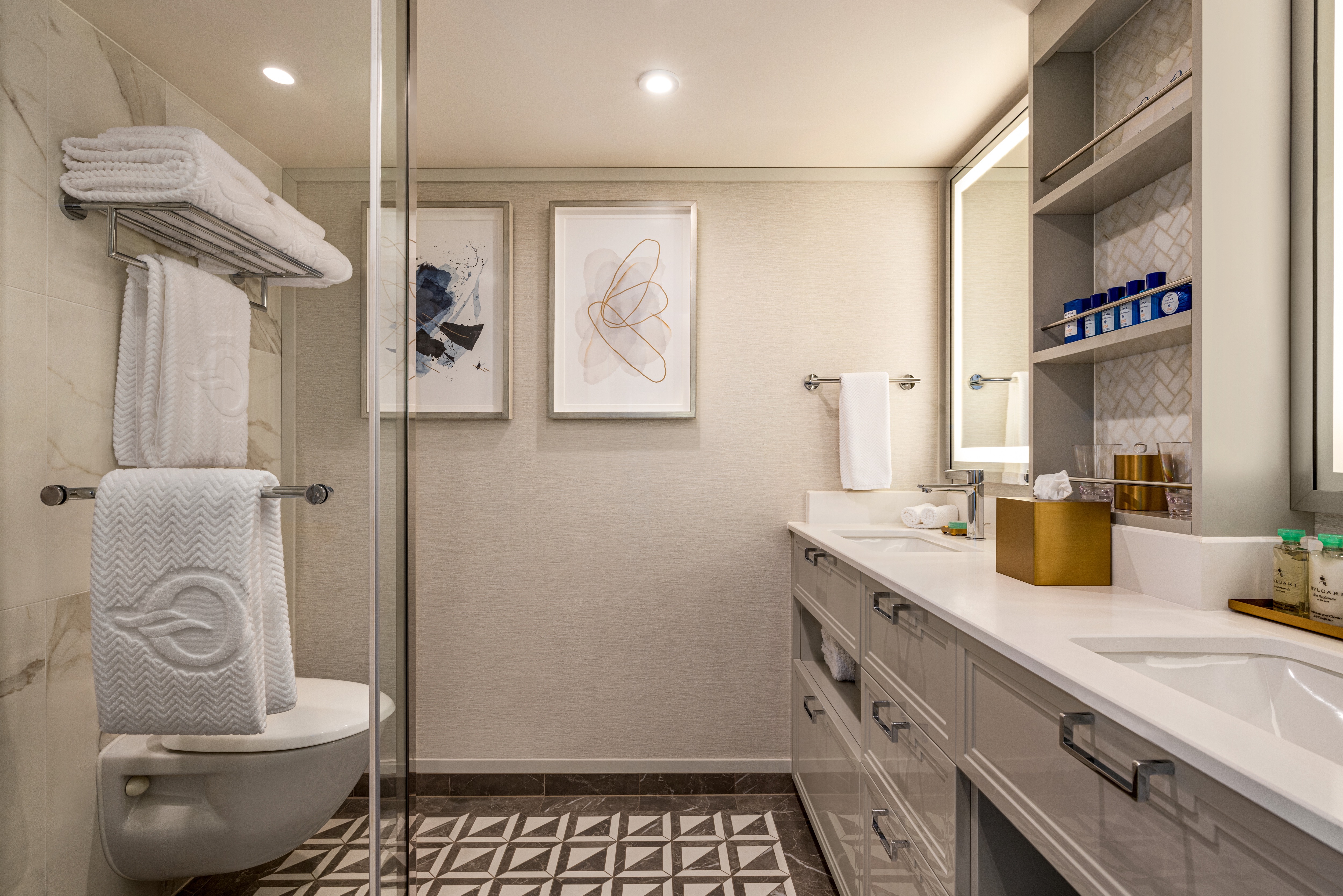
Oceania Vista's Owner’s Suites span the full beam of the ship and showcase sweeping walls of glass that celebrate the stunning seaside views. These sun-filled retreats feature luxurious fabrics, designer furnishings and thoughtful touches that exude opulence yet call on familiar comforts to create the ultimate home at sea. Savor an in-suite dinner in the elegant dining room and then indulge in convivial conversation within the stylish comfort of the inviting living area. In the spacious master bedroom, bask in sublime relaxation with a plush king-size bed and a master bath featuring spa-caliber facilities. Expansive verandas off both the living room and master bedroom promise moments of cherished privacy as you survey the world from the pinnacle of luxurious living.
+Owner’s Suite square footage varies according to deck location.
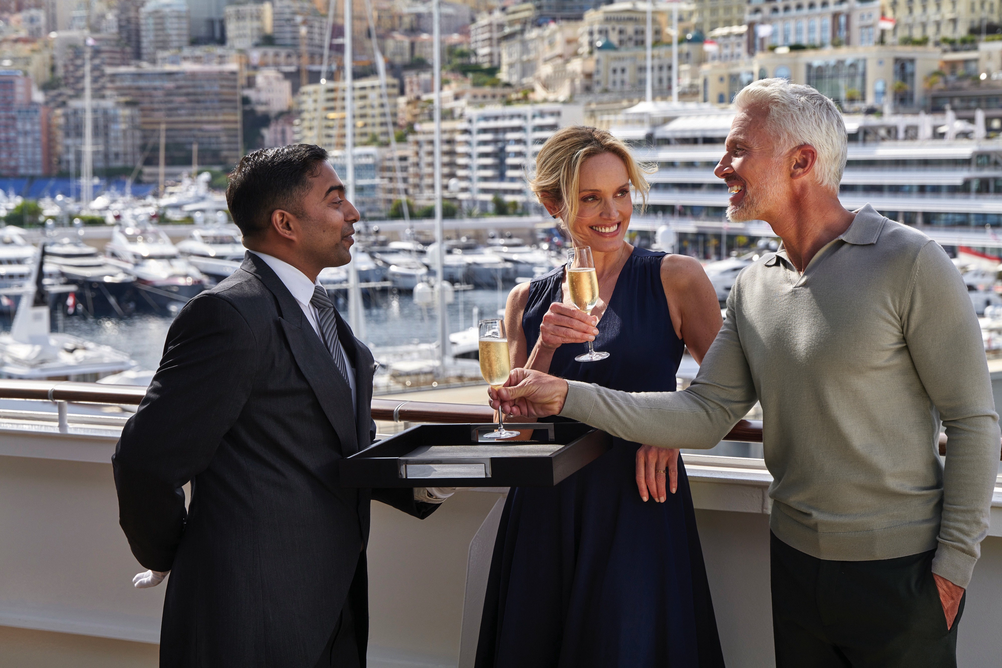
Owner's Suite Privileges
+In addition to Concierge Level privileges
- Priority luggage delivery
- Exclusive card-only access to private Executive Lounge staffed by a dedicated Concierge featuring complimentary sodas, coffees and snacks throughout the day
- 24-hour Butler service
- Optional private in-suite embarkation day lunch from noon to 2 pm in Owner’s Suites
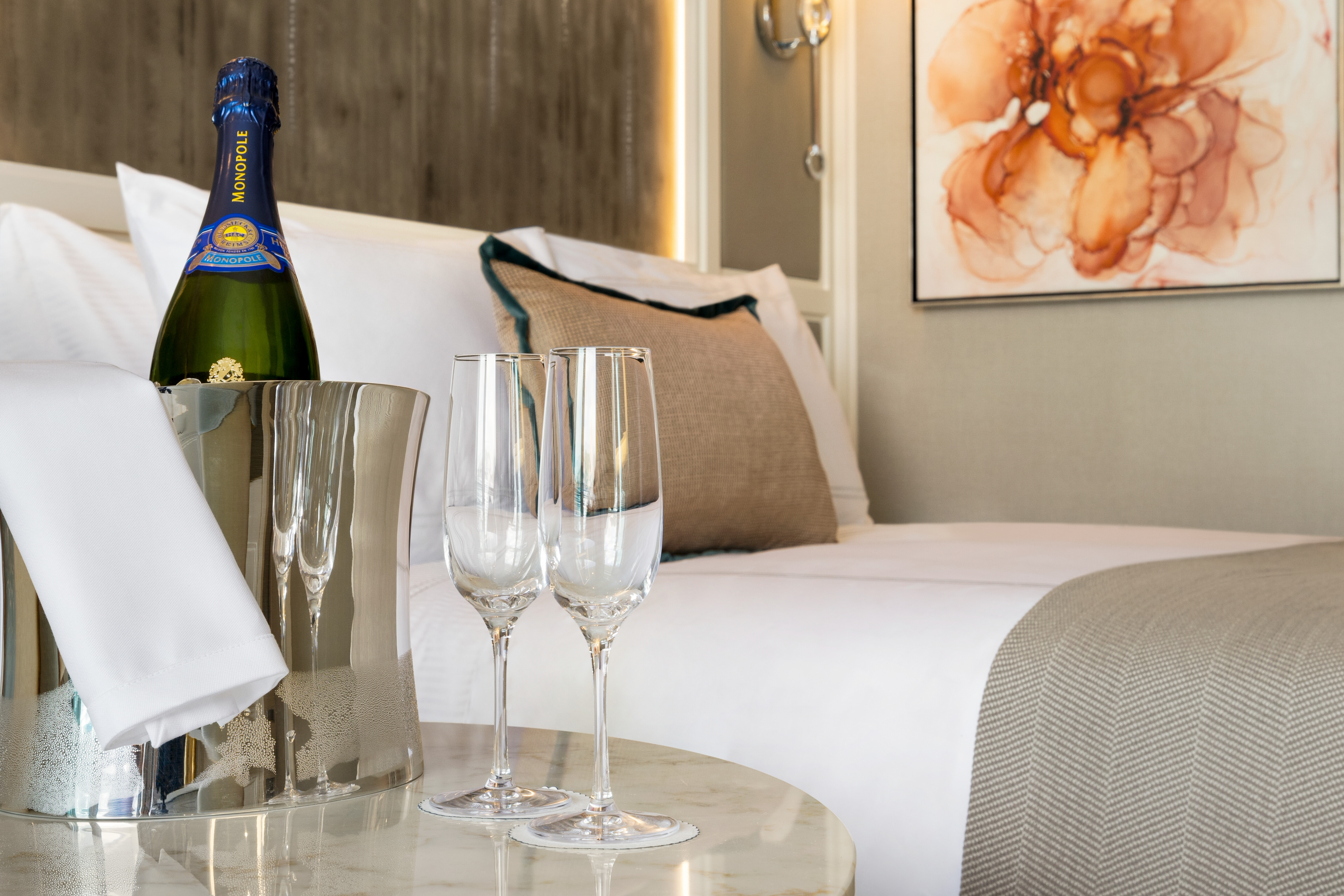
- Complimentary in-suite bar setup with 6 full-size bottles of your choice of premium spirits and wines from our suite beverage menu
- Complimentary welcome bottle of Champagne
- In-suite illy® coffee maker and pods
- Fresh fruit basket upon request
- Choice of daily newspaper
- Exclusive pillow menu
- Course-by-course in-suite dining+
- Order in from any of our specialty restaurants+
- Coordination of shoreside dinner and entertainment reservations
- Last-minute luggage collection
- Packing and unpacking upon request
- Complimentary garment pressing+
- Complimentary shoeshine service
- Gourmet evening canapés upon request
- Special services upon request
+Up to 20 garments per laundry bag; additional restrictions apply.
++Certain limitations apply.
Smoking in suites, staterooms and on verandas is strictly prohibited.

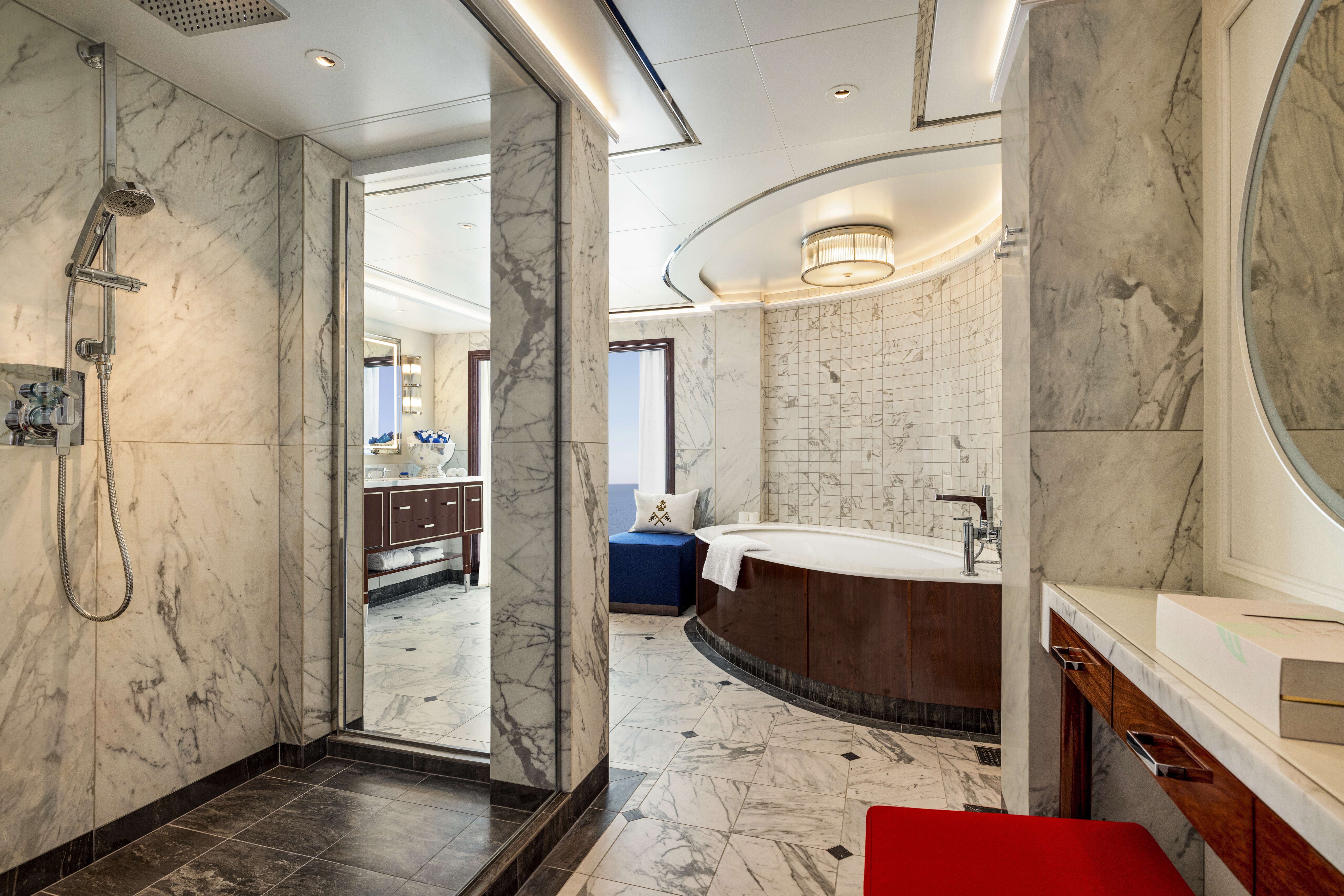
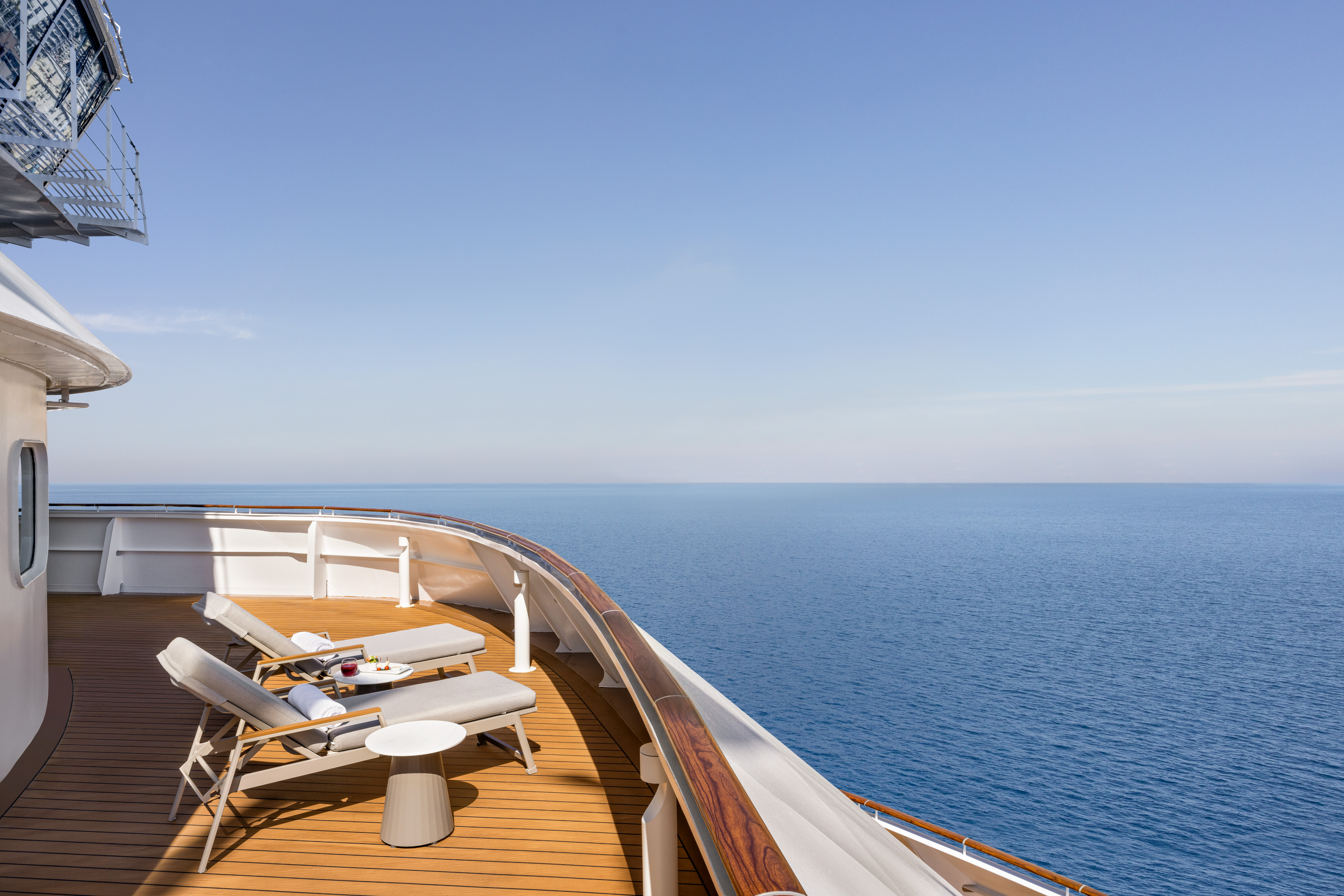
Offering the loftiest of locations that afford sweeping 180-degree views and 1,450 to 1,850 square feet of living space, the eight Vista Suites are designed to be the ultimate seaside villas. Swathed in subtle tones that pay deference to the sea and sky and accented by luminescent marbles, granites and rich weathered oak, each is a true retreat. The airy living room is flanked by a handsome dining room and bar area, which feature commanding views and open onto the expansive teak veranda. An extravagant master suite features a capacious wardrobe room and dressing area adjacent to the oversized and sunlit master bathroom complete with porcelain soaking tub. Vista Suites offer an additional layer of pampering with 24-hour Butler service and access to the suites-only Executive Lounge.
Vista Suite Privileges
+In addition to Concierge Level privileges
- Priority luggage delivery
- Exclusive card-only access to private Executive Lounge staffed by a dedicated Concierge featuring complimentary sodas, coffees and snacks throughout the day
- 24-hour Butler service
- Complimentary in-suite bar setup with 6 full-size bottles of your choice of premium spirits and wines from our suite beverage menu
- Complimentary welcome bottle of Champagne
- In-suite illy® coffee maker and pods
- Fresh fruit basket upon request
- Choice of daily newspaper
- Exclusive pillow menu
- Course-by-course in-suite dining+
- Order in from any of our specialty restaurants+
- Coordination of shoreside dinner and entertainment reservations
- Last-minute luggage collection
- Packing and unpacking upon request
- Complimentary garment pressing+
- Complimentary shoeshine service
- Gourmet evening canapés upon request
- Special services upon request
+Up to 20 garments per laundry bag; additional restrictions apply.
++Certain limitations apply.
Smoking in suites, staterooms and on verandas is strictly prohibited.
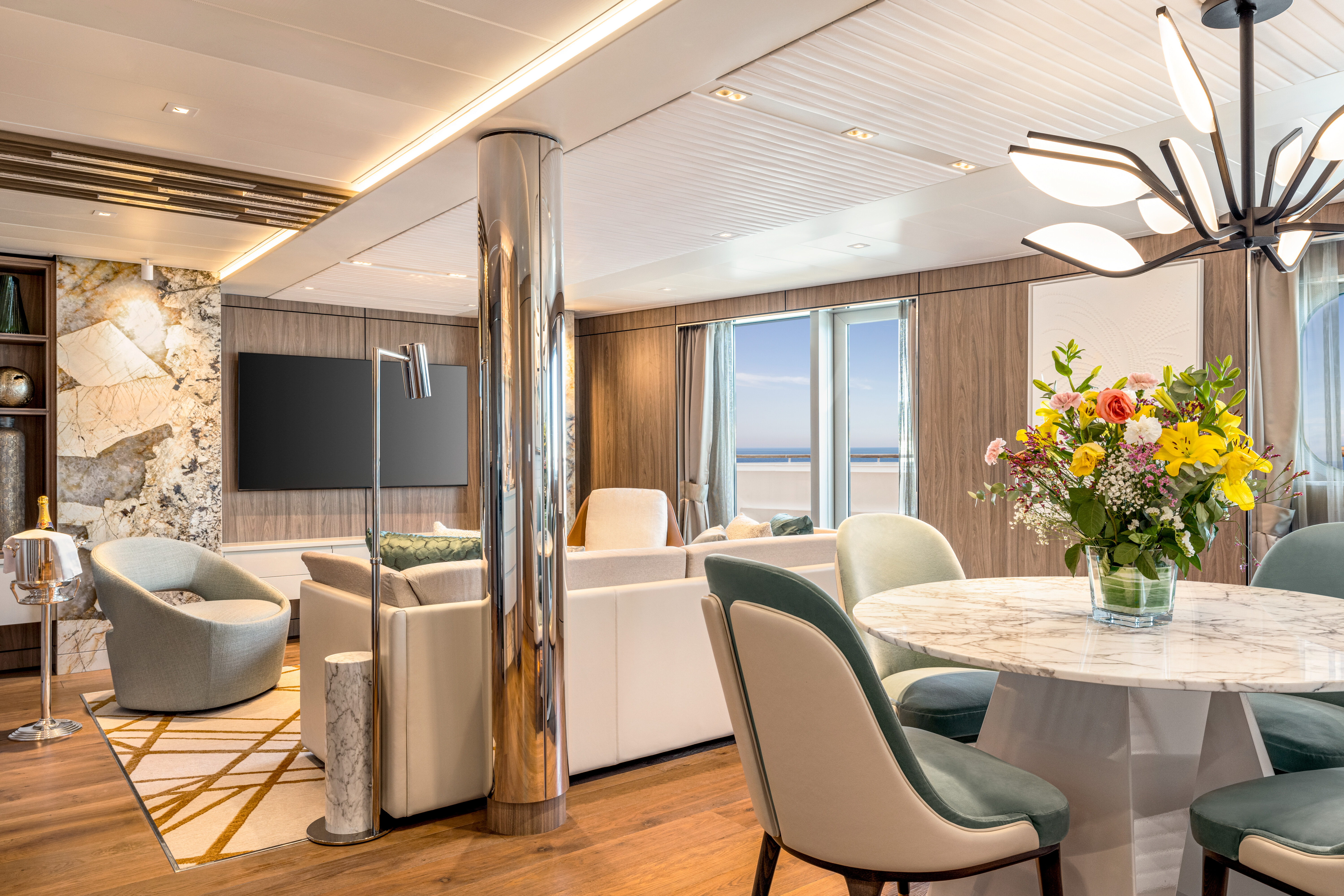
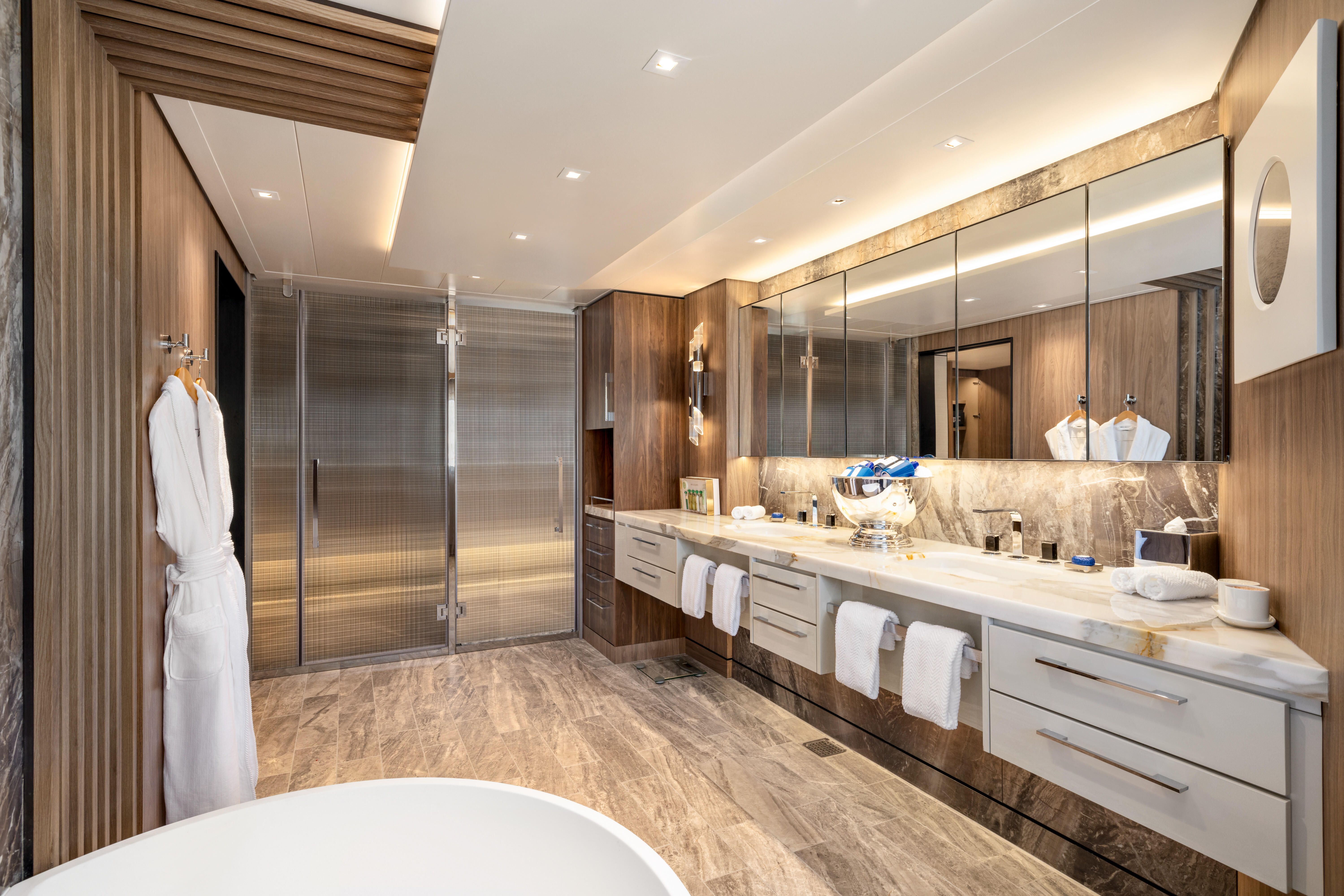
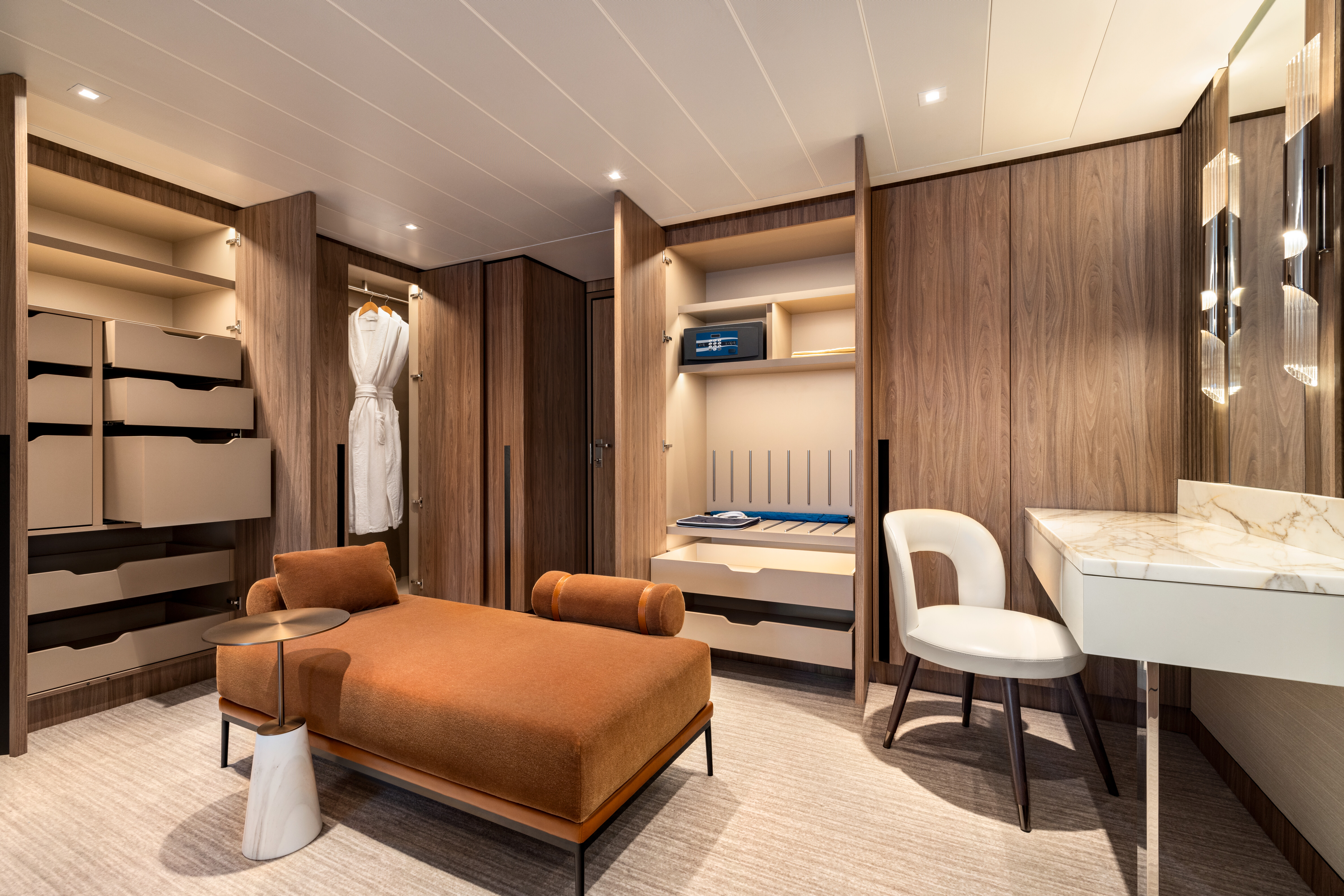
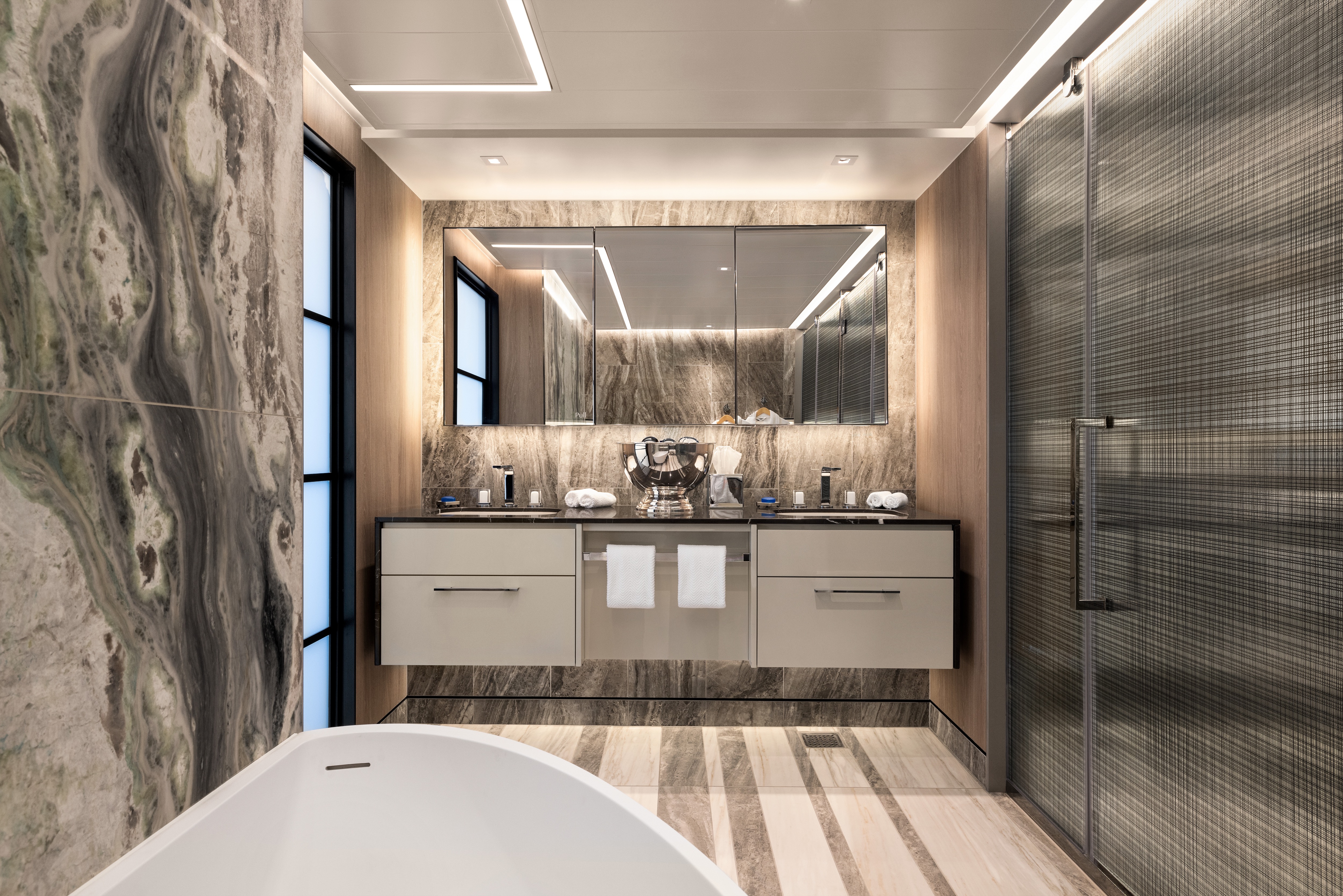
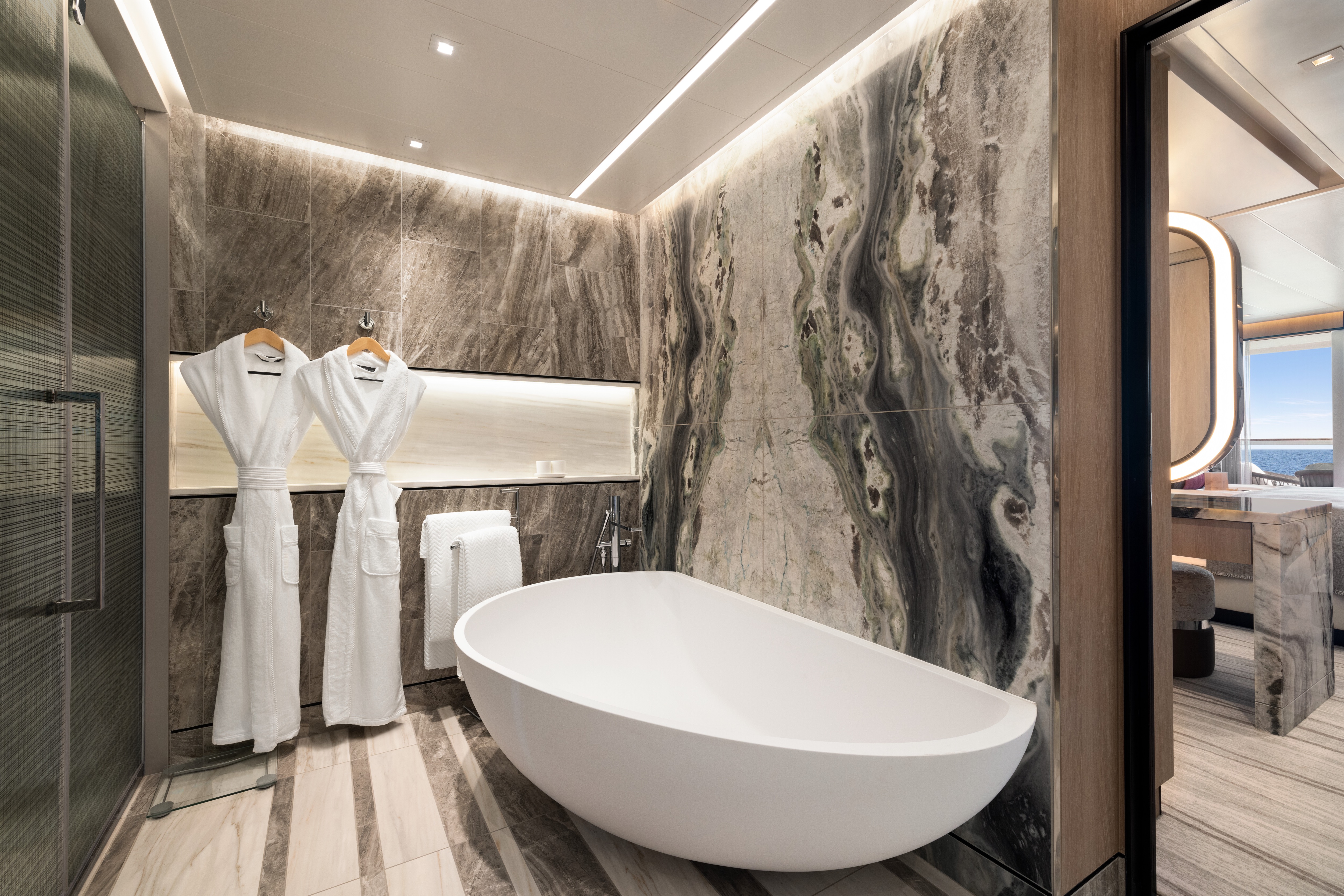
Spacious and sophisticated with a metropolitan flair, the 14 Oceania Suites are situated in prime locations atop the ship to offer unparalleled views. Averaging approximately 1,000 to 1,200 square feet, each radiates an ambiance of exquisite residential luxury. Thoughtfully appointed living and dining spaces, including the oversized private teak veranda, invite gracious entertaining while the master bedroom provides the perfect retreat for relaxation with its grand king-size bed, dressing room and opulent marble-clad bathroom. Each home away from home features the added luxury of a cozy study or guest studio and guest bathroom. Oceania Suites offer a dedicated Butler and keycard access to the suites-only Executive Lounge.
Oceania Suite Privileges
+In addition to Concierge Level privileges
- Priority luggage delivery
- Exclusive card-only access to private Executive Lounge staffed by a dedicated Concierge featuring complimentary sodas, coffees and snacks throughout the day
- 24-hour Butler service
- Complimentary in-suite bar setup with 6 full-size bottles of your choice of premium spirits and wines from our suite beverage menu
- Complimentary welcome bottle of Champagne
- In-suite illy® coffee maker and pods
- Fresh fruit basket upon request
- Choice of daily newspaper
- Exclusive pillow menu
- Course-by-course in-suite dining+
- Order in from any of our specialty restaurants+
- Coordination of shoreside dinner and entertainment reservations
- Last-minute luggage collection
- Packing and unpacking upon request
- Complimentary garment pressing+
- Complimentary shoeshine service
- Gourmet evening canapés upon request
- Special services upon request
+Up to 20 garments per laundry bag; additional restrictions apply.
++Certain limitations apply.
Smoking in suites, staterooms and on verandas is strictly prohibited.
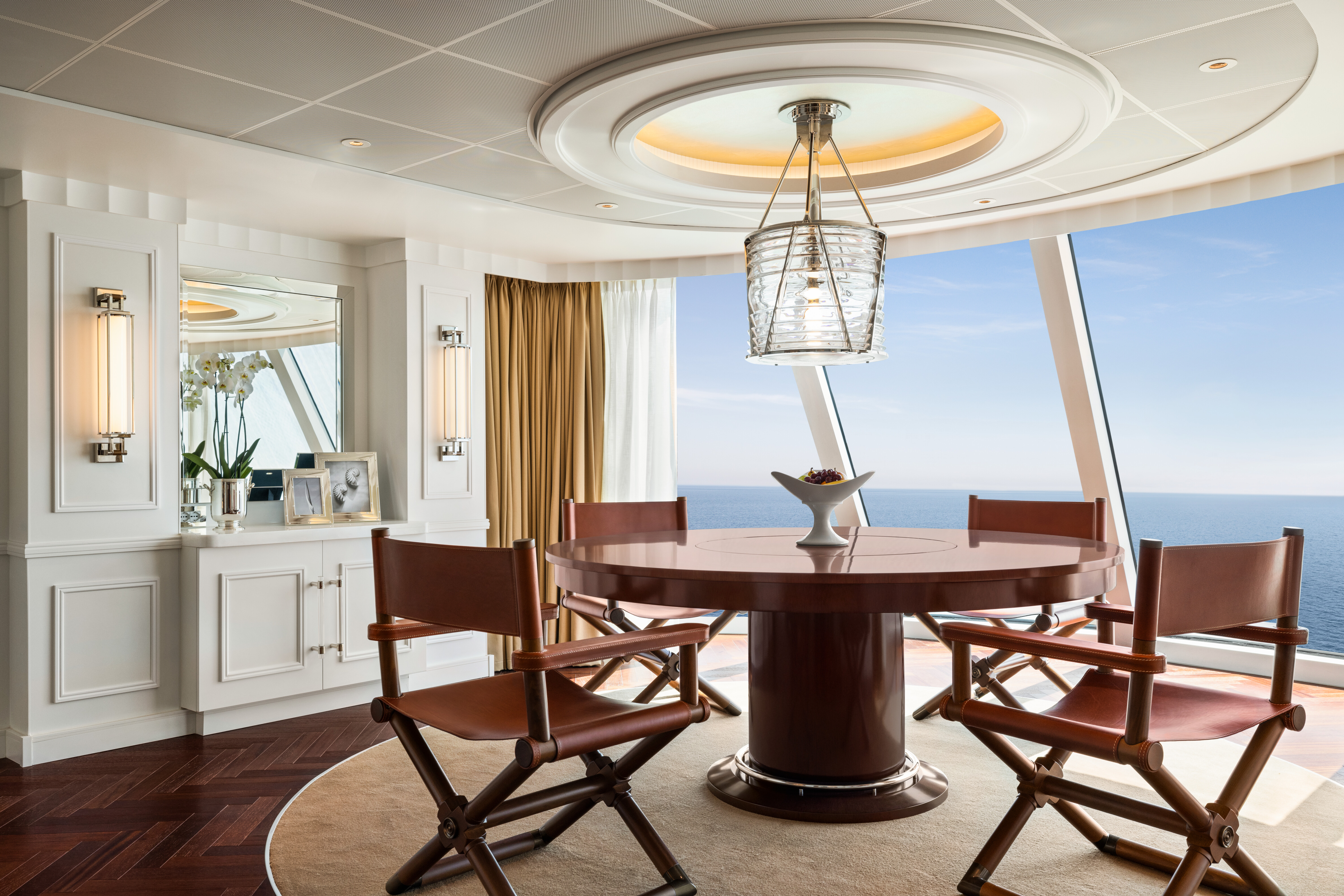
An overabundance of space and elevated levels of luxury define the Penthouse Suite experience. Ingenious design and tony furnishings punctuate the space, which is resplendent in rich upholstery, fine leathers and stunning works of art. Measuring 440 square feet, Penthouse Suites feature the added luxuries of a walk-in closet, an oversized bathroom with dual vanities and of course, a large private veranda overlooking the sea. Penthouse guests also have unlimited use of the sublime Aquamar Spa Terrace along with Butler service and keycard access to the suites-only Executive Lounge with a dedicated Concierge.
Penthouse Suite Privileges
+In addition to Concierge Level privileges
- Priority luggage delivery
- Exclusive card-only access to private Executive Lounge staffed by a dedicated Concierge featuring complimentary sodas, coffees and snacks throughout the day
- 24-hour Butler service
- Course-by-course in-suite dining+
- Order in from any of our specialty restaurants+
- Coordination of shoreside dinner and entertainment reservations
- Last-minute luggage collection
- Packing and unpacking upon request
- Complimentary garment pressing+
- Complimentary shoeshine service
- Gourmet evening canapés upon request
- Special services upon request
++Certain limitations apply.
Smoking in suites, staterooms and on verandas is strictly prohibited.
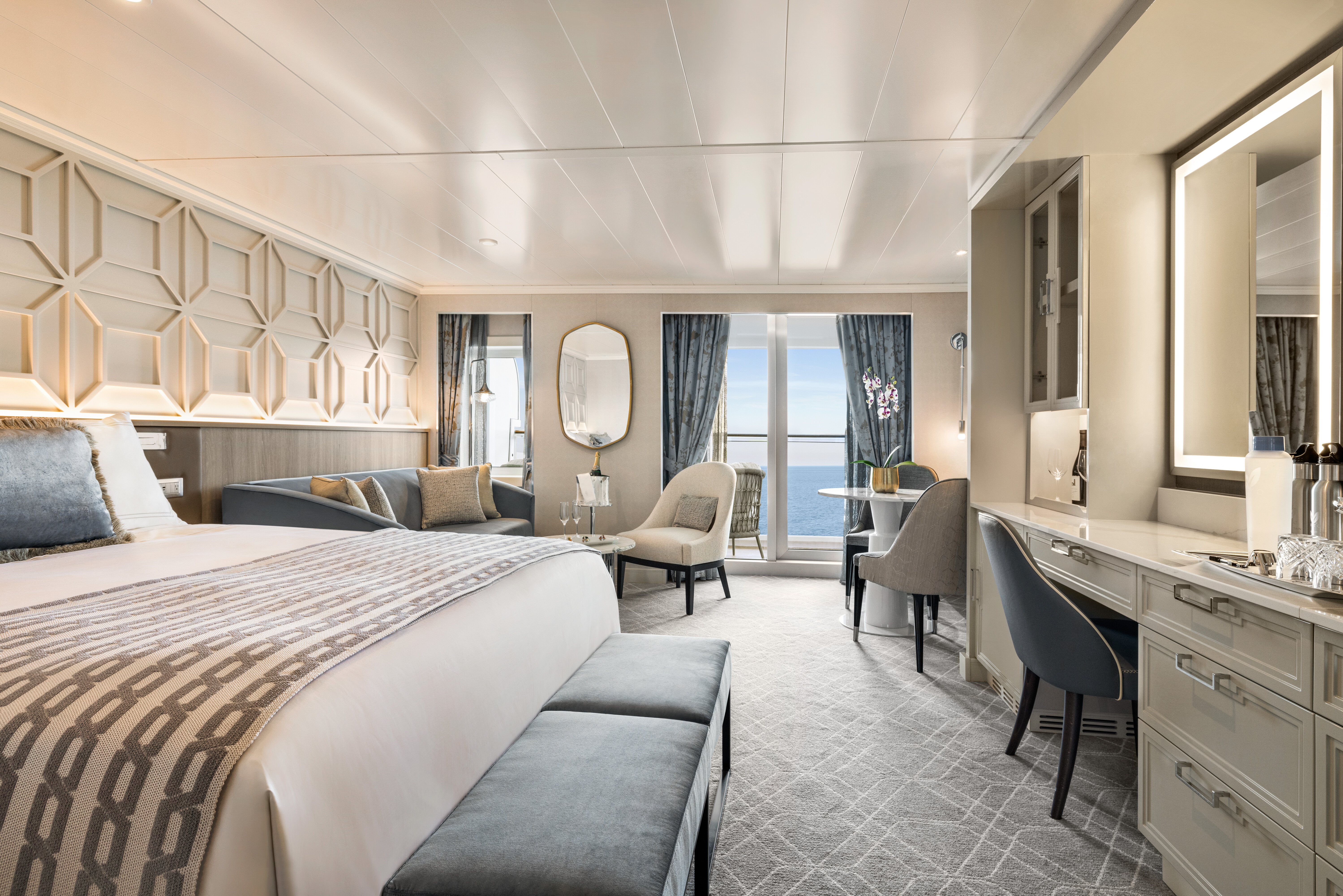
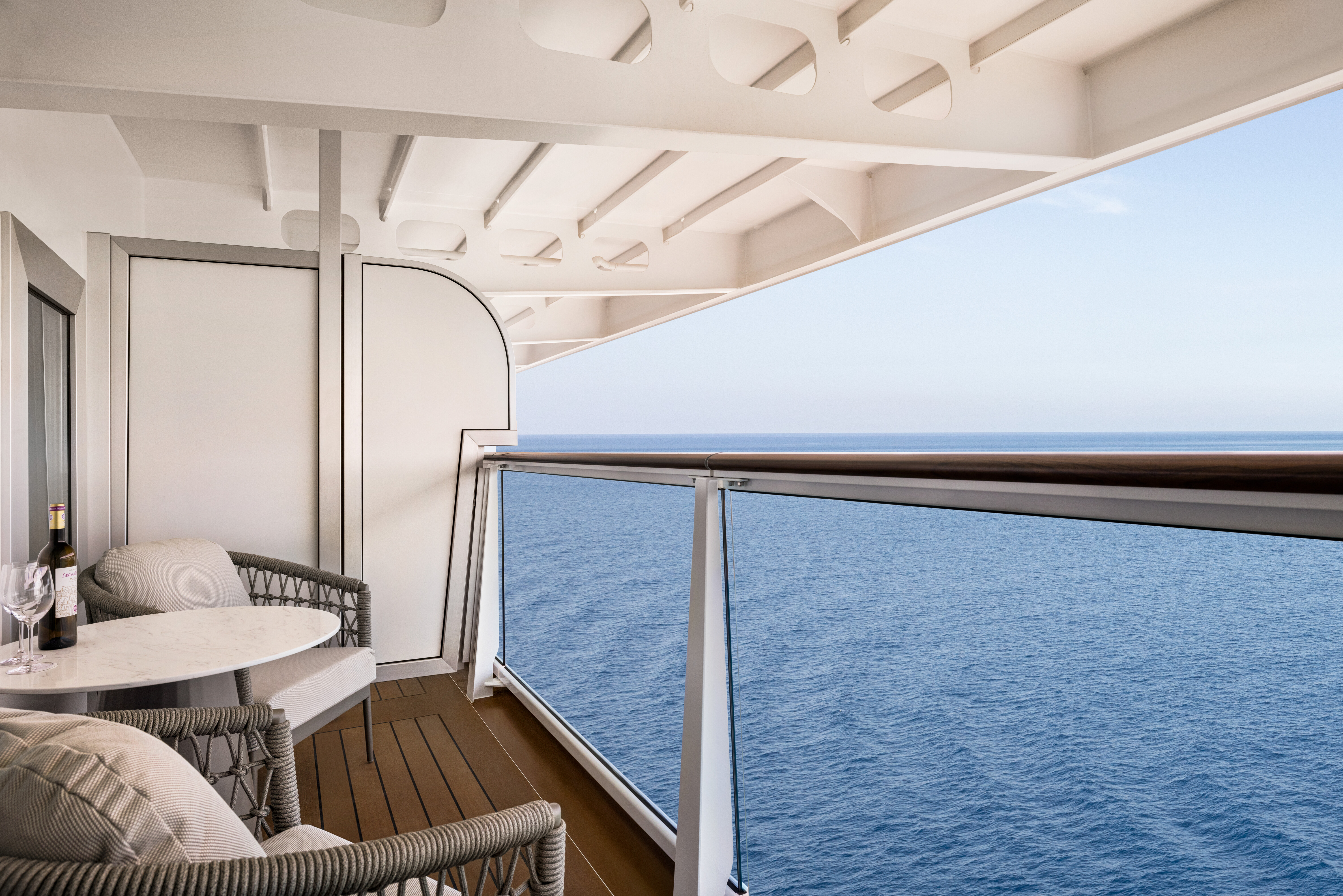
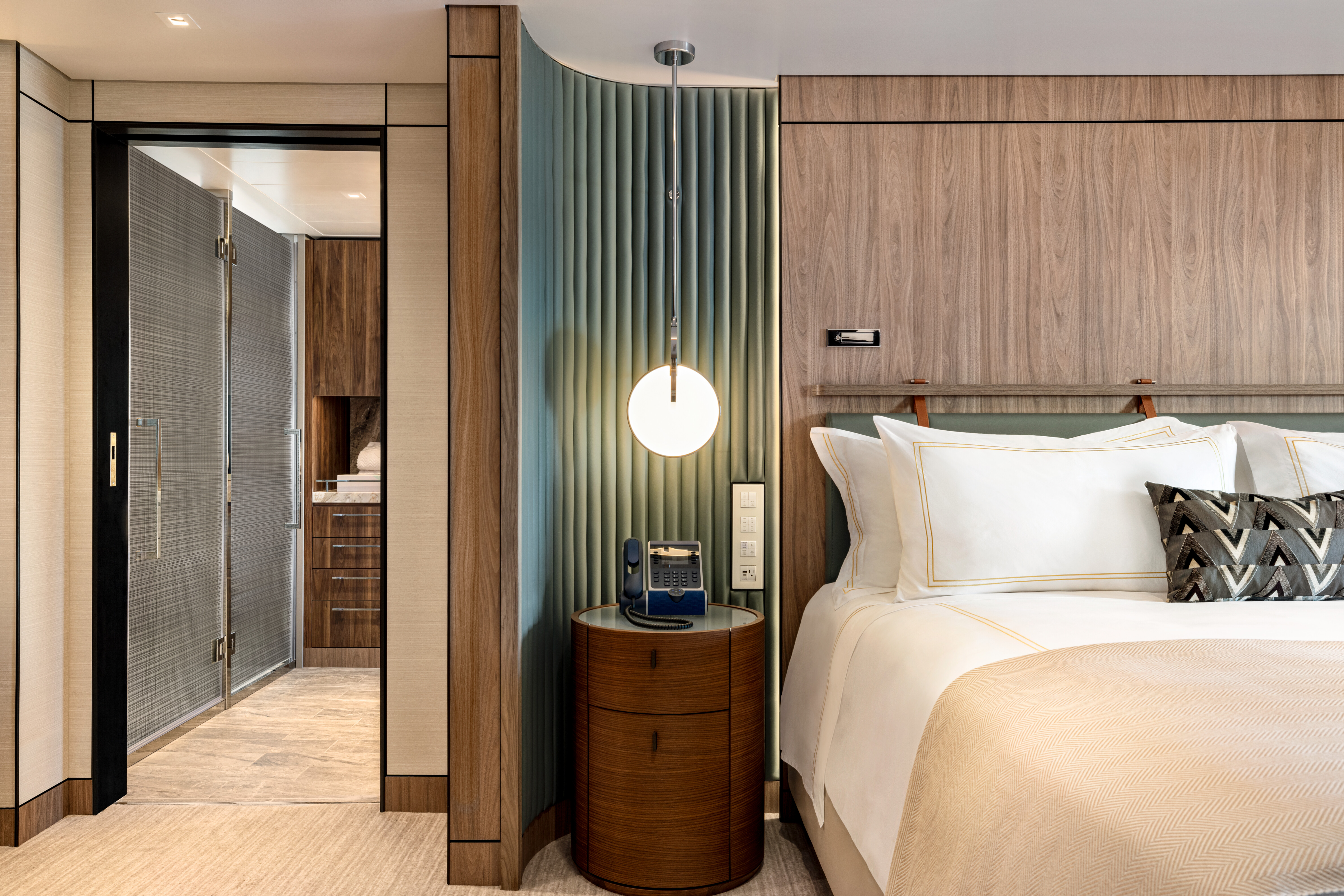
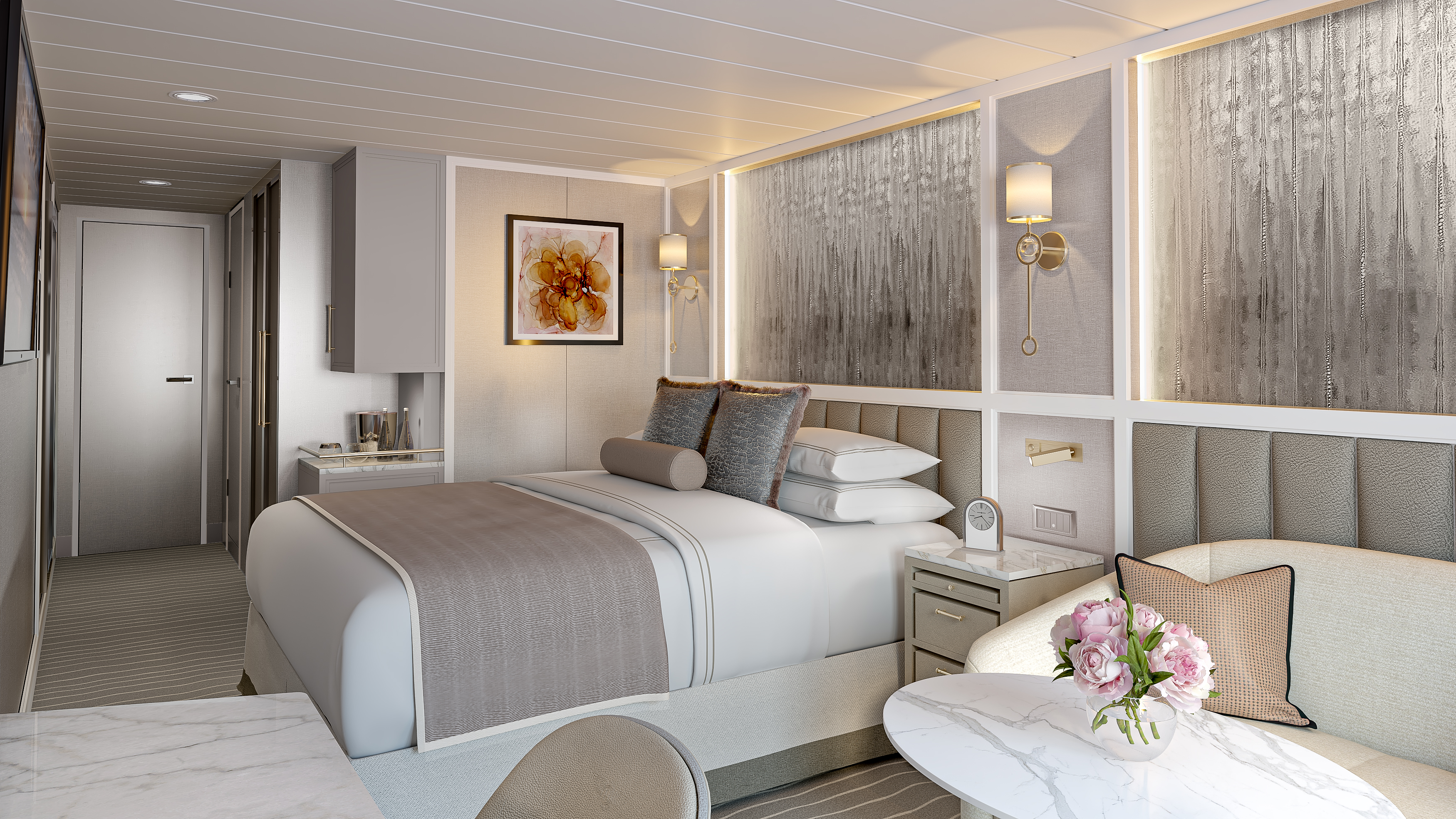
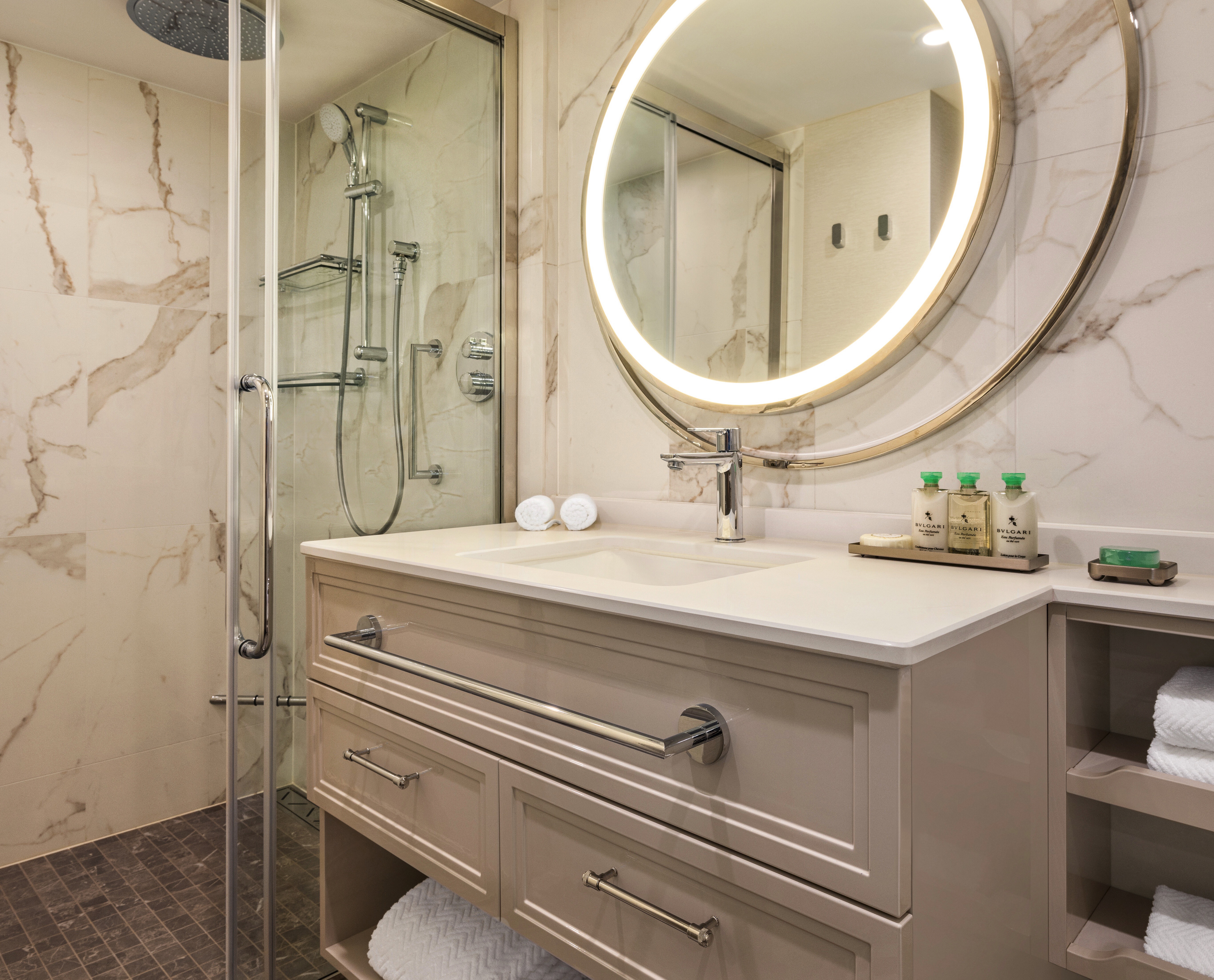
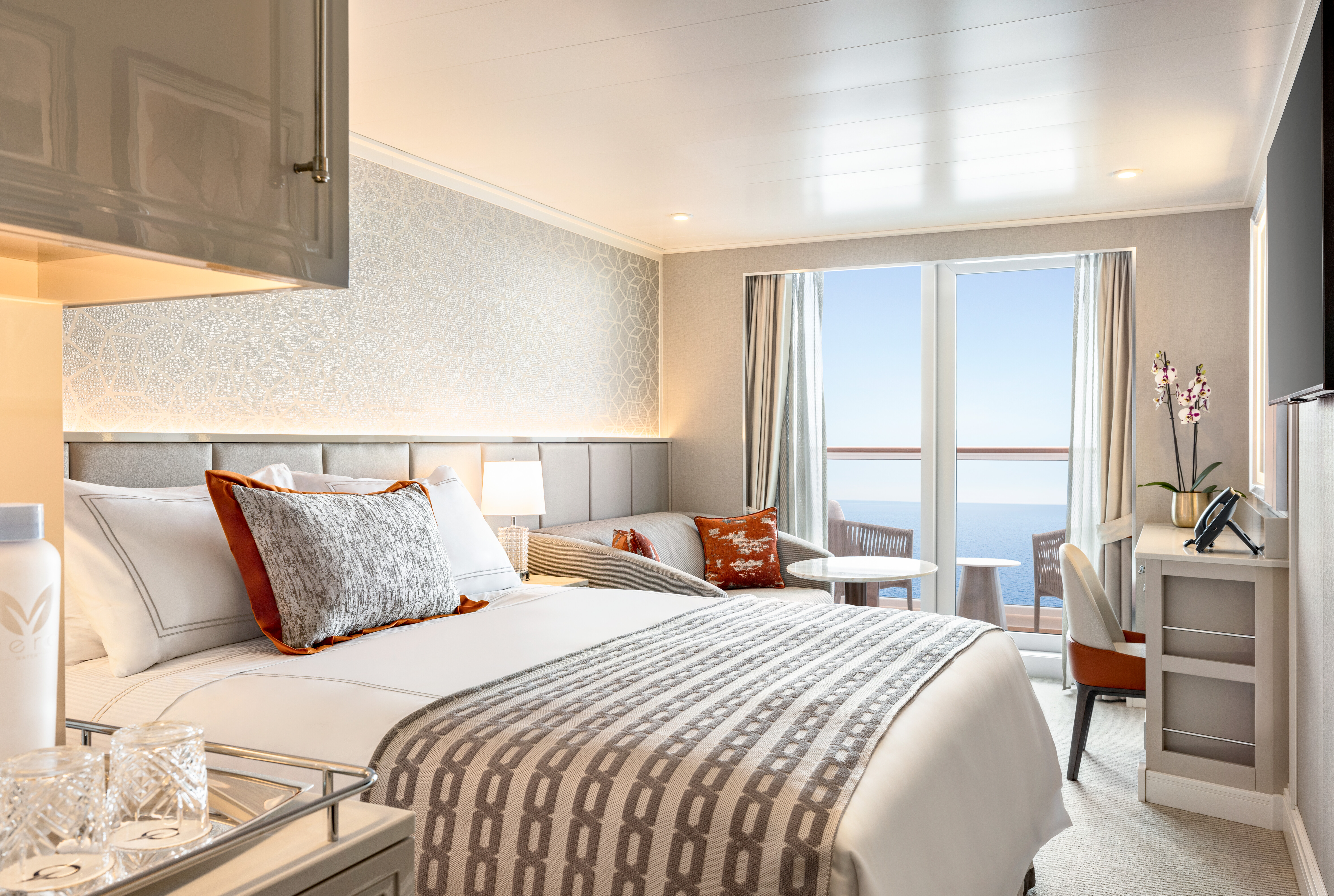
Oceania Vista’s Concierge Level Veranda Staterooms envelop guests in lavish comfort. Shades of cream and rich fawn set the tone for a luxuriant respite with an extravagantly dressed queen-size Tranquility Bed, sumptuously comfortable sitting area and a private veranda to take in the marvels of the surrounding seascapes. All feature extraordinary closet and storage space, and a marble bathroom with walk-in rainforest shower. A wealth of additional amenities, such as a dedicated Concierge Lounge, unlimited use of the Aquamar Spa Terrace, room service from The Grand Dining Room and free laundry services, elevates the experience to the sublime.
Exclusive Concierge Privileges
+In addition to stateroom amenities
- Expanded lunch and dinner room service menu from The Grand Dining Room
- FREE laundry service - up to 3 bags per stateroom*
- Exclusive card-only access to private Concierge Lounge staffed by a dedicated Concierge featuring complimentary sodas, coffees and snacks throughout the day
- Complimentary welcome bottle of Prosecco
- Priority online specialty restaurant reservations
- Private teak veranda††
- Unlimited access to the Aquamar® Spa Terrace
- Complimentary Oceania Cruises logo tote bag
- Cashmere lap blankets, perfect for relaxing on your veranda
- Complimentary pressing of garments upon embarkation**
- Complimentary shoeshine service
+Up to 20 garments per laundry bag; additional restrictions apply.
++Certain limitations apply.Smoking in suites, staterooms and on verandas is strictly prohibited.
Solo travelers have a fresh reason to delight in this new category of stateroom designed exclusively for them. Spacious and airy yet cozy, each features all of the comforts and luxuries world travelers expect. Concierge Level Solo Veranda Staterooms offer a sitting area overlooking the private veranda, separate sleeping area with a sumptuously comfortable Tranquility Bed and copious storage space. Solo guests, like all sailing in Concierge Level, receive an astonishing array of amenities such as free laundry service and keycard access to the exclusive Concierge Lounge and unlimited use of the sublime Aquamar Spa Terrace.
Concierge Level Privileges
+In addition to stateroom amenities
Expanded lunch and dinner room service menu from The Grand Dining Room
- Private teak veranda††
- FREE laundry service - up to 3 bags per stateroom*
- Exclusive card-only access to private Concierge Lounge staffed by a dedicated Concierge featuring complimentary sodas, coffees and snacks throughout the day
- Complimentary welcome bottle of Prosecco
- Priority online specialty restaurant reservations
- Unlimited access to the Aquamar® Spa Terrace
- Complimentary Oceania Cruises logo tote bag
- Cashmere lap blankets, perfect for relaxing on your veranda
- Complimentary pressing of garments upon embarkation**
- Complimentary shoeshine service
*Up to 20 garments per laundry bag; additional restrictions apply
**Certain limitations apply
Smoking in suites, staterooms and on verandas is strictly prohibited
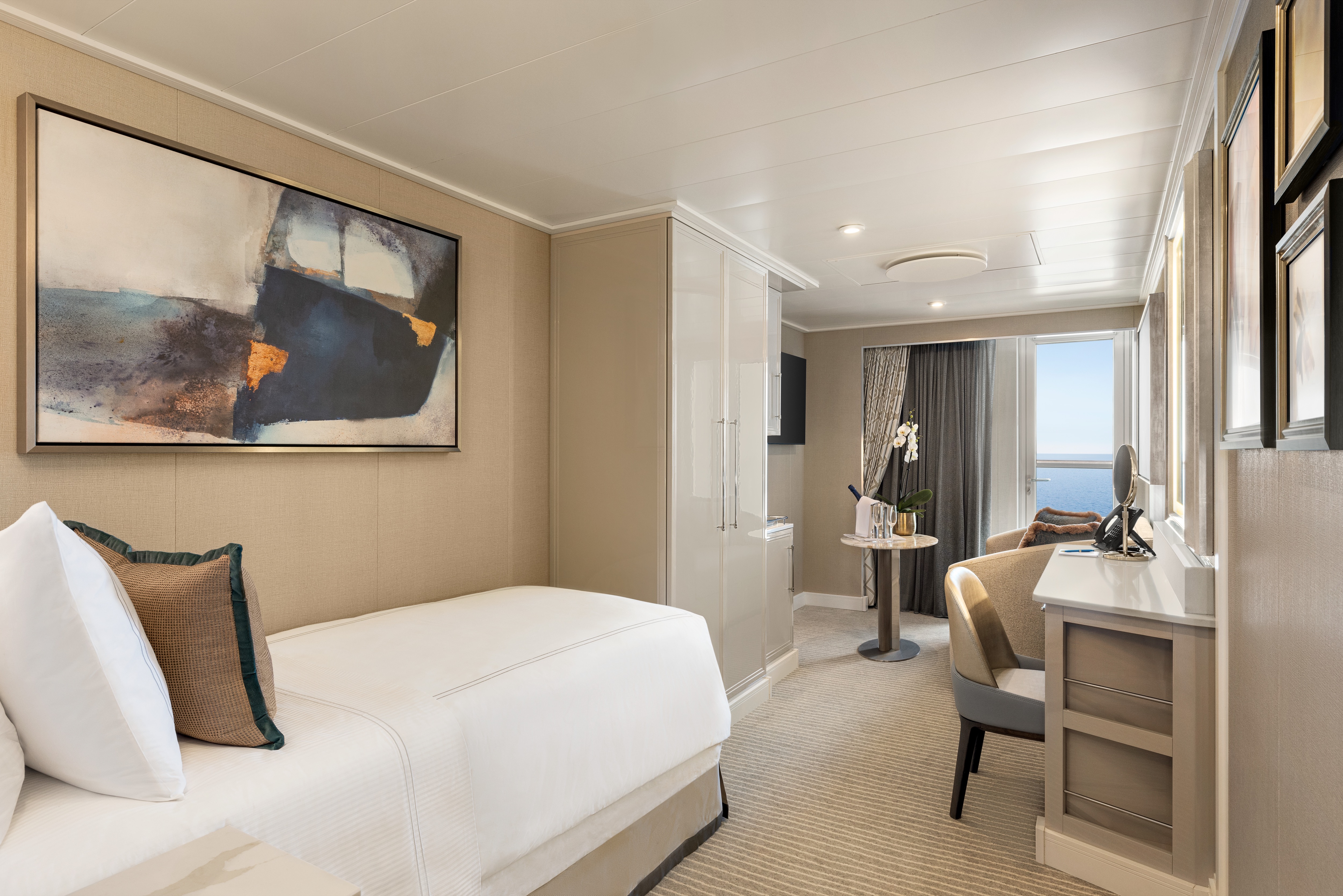
Like the ubiquitous little black dress, timeless elegance is a universal staple of Oceania Vista's Veranda Staterooms. Within an expansive 290 square feet, residential warmth is reflected in soothing neutral shades with splashes of sienna. High-tech amenities and ample closet space are de rigueur. The embrace of a lush queen-size bed is complemented by a lavishly appointed bathroom with a large vanity and captivating rainforest shower. A comfortable sitting area is a relaxing prelude to time spent on the private veranda, watching the world glide past.
Veranda Stateroom Amenities
- Tranquility Bed, an Oceania Cruises exclusive†
- FREE sodas replenished daily in your refrigerated mini-bar
- FREE still and sparkling Vero Water®
- Aquamar® Bath + Skincare Essentials
- FREE room service menu 24 hours a day
- Daily housekeeping service
- Gourmet turndown chocolates upon request
- Interactive television system with on-demand movies, weather and more
- Starlink® WiFi service
- Writing desk and stationery
- Plush cotton towels, robes and slippers
- Handheld hair dryer
- Security safe
†King-size bed (cannot be converted into twin beds) for Owner’s, Vista and Oceania Suites and queen-size bed for all other suites and staterooms (Tranquility Bed available for purchase at OceaniaBedCollection.com)
††Featured with all Veranda Staterooms (excluding French Veranda)
Smoking in suites, staterooms and on verandas is strictly prohibited
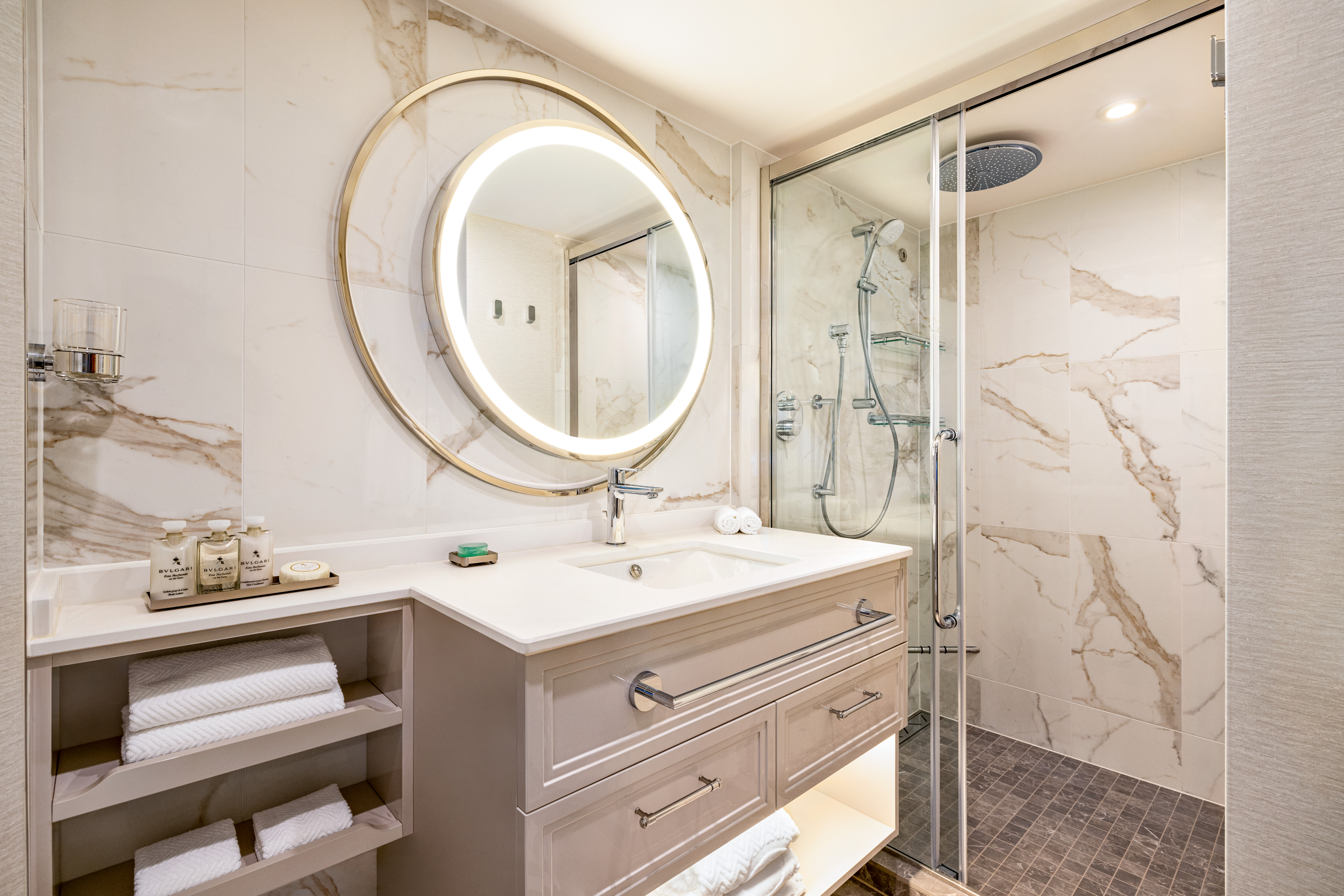
A seaside home should joyously enfold the ocean and in every French Veranda Stateroom, that promise is fulfilled. Fling open a floor-to-ceiling glass door that opens onto the graceful banister of the French veranda and transform your entire residence into an open-air terrace reminiscent of a chic hillside villa on the Côte d’Azur. These spacious havens feature an enticing queen-size bed, separate sitting area and comfortable furnishings that exude relaxation and sense of the familiar. Attention to detail is meticulous, including a roomy bathroom with an indulgent rainforest shower.
French Veranda Stateroom Amenities
- Tranquility Bed, an Oceania Cruises exclusive†
- FREE sodas replenished daily in your refrigerated mini-bar
- FREE still and sparkling Vero Water®
- Aquamar® Bath + Skincare Essentials
- FREE room service menu 24 hours a day
- Daily housekeeping service
- Gourmet turndown chocolates upon request
- Interactive television system with on-demand movies, weather and more
- Starlink® WiFi service
- Writing desk and stationery
- Plush cotton towels, robes and slippers
- Handheld hair dryer
- Security safe
†King-size bed (cannot be converted into twin beds) for Owner’s, Vista and Oceania Suites and queen-size bed for all other suites and staterooms (Tranquility Bed available for purchase at OceaniaBedCollection.com)
††Featured with all Veranda Staterooms (excluding French Veranda)
Smoking in suites, staterooms and on verandas is strictly prohibited
Oceania Vista
Your World From A New Perspective
Step aboard Oceania Vista and you’ll discover a dramatic new way of seeing the world. Vista invites you to savor your experience on a ship whose captivating beauty and stylish design evoke the wonders you’ll discover ashore. Stunning interiors and harmonious spaces reflect a fresh, new perspective through organic elements inspired by the land and sea. Sail to fascinating destinations in faraway lands while enjoying The Finest Cuisine at Sea® and personalized service that distinguish every ship in our fleet along with several unique firsts in the realms of dining, accommodations and guest experience.
Ship Facts
| Launch Year | 2023 | ||||||||
| Refit Year | |||||||||
| Language | en | ||||||||
| Gross Tonnage | 68000 | ||||||||
| Length | 241 | ||||||||
| Width | 32 | ||||||||
| Currency | USD | ||||||||
| Speed | 20 | ||||||||
| Capacity | 1200 | ||||||||
| Crew Count | 800 | ||||||||
| Deck Count | 11 | ||||||||
| Cabin Count | 603 | ||||||||
| Large Cabin Count | N/A | ||||||||
| Wheelchair Cabin Count | N/A | ||||||||
| Electrical Plugs |
|
Deck 16
- Paddle Tennis
- Golf Putting Greens
- Restrooms

Deck 15
- Croquet/Bocce
- Shuffleboard
- Fitness Track
- Fitness Centre
- Aquamar Spa
- Barber Shop
- Styling Salon
- Sauna/Steam Rooms
- Aquamar Spa Terrace
- Elevator
Deck 14
- Priveé
- Toscana
- Polo Grill
- Bakery
- Library
- Baristas
- Sun Deck
- The Culinary Centre
- Artist Loft
- LYNC Digital Centre
- Conference Centre
- Horizons
- Elevator
- Restroom
Deck 12
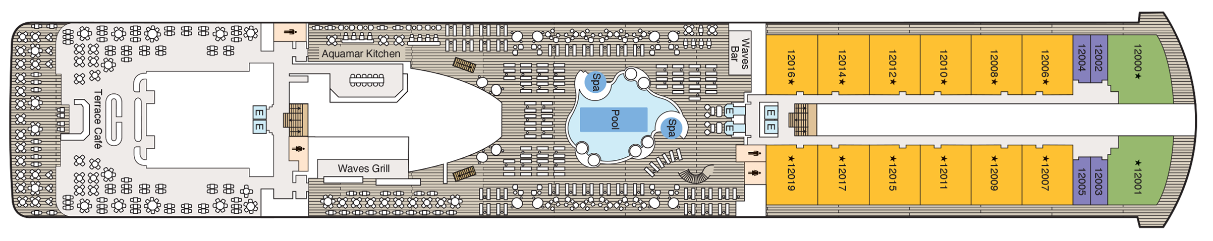
- Terrace Café
- Aquamar Kitchen
- Waves Grill
- Pool
- Whirlpools
- Waves Bar
- Concierge Level Veranda
- Oceania Suite
- Vista Suite
- Elevator
- Restroom
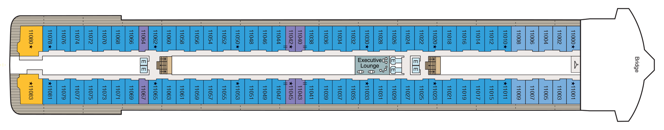
Deck 11
- Executive Lounge
- Concierge Level Veranda
- Oceania Suite
- Penthouse Suite
- Launderette
- Bridge
- Elevator
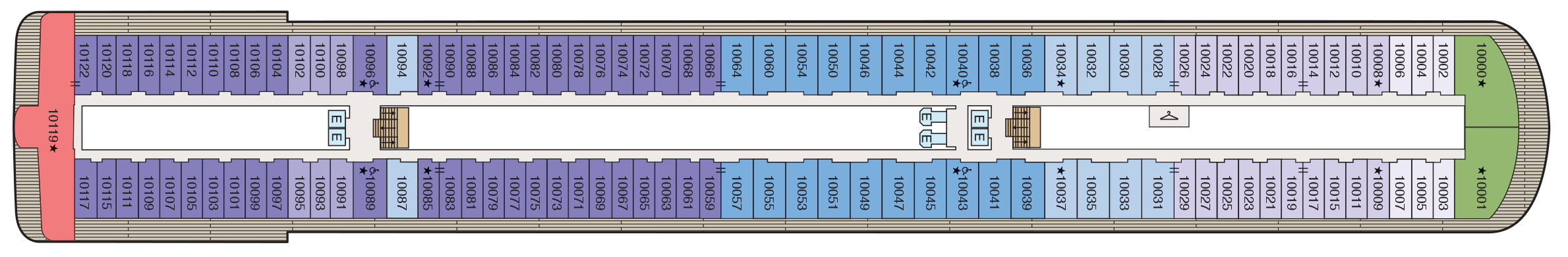
Deck 10
- Concierge Level Veranda
- Owner's Suite
- Penthouse Suite
- Vista Suite
- Launderette
- Elevator
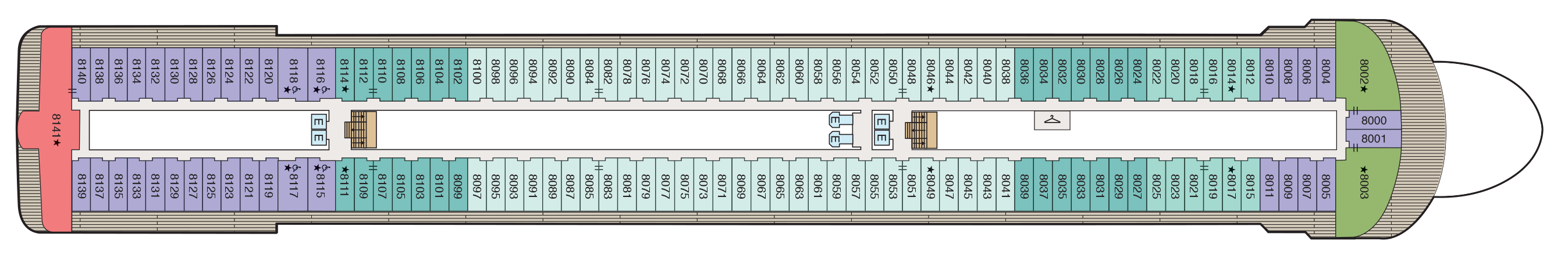
Deck 9
- Concierge Lounge
- Concierge Level Veranda
- Concierge Level Solo Veranda
- Owner's Suite
- Vista Suite
- Launderette
- Elevator

Deck 8
- Concierge Level Veranda
- Owner's Suite
- Veranda Stateroom
- Vista Suite
- Launderette
- Elevator
Deck 7
- Concierge Level Veranda
- Veranda Stateroom
- French Veranda
- Penthouse Suite
- Launderette
- Elevator

Deck 6
- Grand Lounge
- Upper Hall
- Martinis
- Casino
- Casino Bar
- The Grand Dining Room
- Elevator

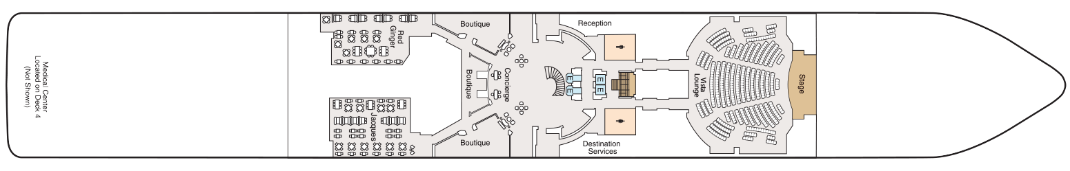
Deck 5
- Red Ginger
- Jacques
- Boutiques
- Concierge
- Elevator
- Reception
- Destination Services
- Lounge
- Stage
- Restroom
- Medical Centre (Located on Deck 4 - Not Shown)
Culinary Masterpieces
Oceania Vista serves up a fresh perspective on The Finest Cuisine at Sea® and reaches new pinnacles of creativity and diversity with an astounding array of dining options that range from informal to the extravagant. In addition to the tried and true favorites that guests adore, Oceania Vista offers three new indulgent venues. Never content to rest on our laurels, even the expected has become the unexpected through a dramatic re-inspiration of every dining space from decor to table setting to menu offerings.
The Luxury of Casual
You’ll savor cuisine renowned as the finest at sea no matter where you choose to dine or relax on Oceania Vista – whether that means a poolside burger, a scoop of Humphry Slocombe’s bourbon-flavored cornflake-studded Secret Breakfast ice cream or a perfectly prepared cappuccino accompanied by freshly baked biscotti. Our culinary team’s attention to detail, passion for artisanal ingredients and dedication to technique extends to our casual dining, poolside experiences, Baristas coffee bar and the cherished ritual of Afternoon Tea.
In-Room Dining Experiences
After a day of enriching adventures ashore or an enjoyable day on board, dining in the privacy of your suite or stateroom with our compliments is always a welcome possibility. A complete menu of varied dining experiences is available around the clock, featuring an extensive array of delectable breakfast, lunch and dinner items. All suites and staterooms have the added luxury of enjoying a full, hot breakfast in-room and those staying in Concierge Level or above have the additional privilege of ordering from an expanded lunch and dinner room service menu from The Grand Dining Room. Suite guests have the ultimate indulgence of enjoying course-by-course meals from the comfort of their spacious sanctuaries. Revel in the private luxury of your suite or stateroom, and enjoy an exquisite meal on your tranquil veranda as you take in spectacular seascapes.
Immersive Mixology Experiences
When you join us aboard Oceania Vista, enjoying a drink will be an experience unto itself – from the beauty of watching a skilled bartender smoke an Old Fashioned to the tableside preparation of a Manhattan. Our new onboard bar program has been designed to mirror the elevated quality and innovation The Finest Cuisine at Sea® has come to represent. The latest cocktail-crafting trends and techniques have inspired an array of experiences, drinks and beverage offerings such cocktails topped by flavored smoke bubbles, Negronis aged in wooden barrels, delightfully entertaining rum mixology experiences, the ultimate in wine pairings, unique specialty beverage cart experiences and more.
Wine Pairing Experiences
There’s nothing quite like the trifecta of amazing food, delightful wine and lots of laughter. Suited to connoisseurs and novices alike, our wine pairing experiences across our small and luxurious ships are convivial, memorable, and yes, just a touch lavish. Evoking the breezy yet chic sensibility of a small Napa winery, the experiences center on menus of inventive dishes paired with premium, and often rare, vintages hand-selected by our talented chefs and sommeliers. Cruise and dine in style, and book reservations for a range of exciting onboard pairing experiences, such as sommelier-led pairing lunches, a one-of-a-kind six-course Champagne dinner and more. Each is a pure celebration of the joys of gathering around a table. More than anything else, these experiences are tableside joie de vivre.
The Grand Dining Room
The Grand Dining Room is the luxurious grand dame of Oceania Cruises’ culinary world. Here, guests will savor a leisurely dining experience in a truly magnificent and inspired room whose ambiance soars to equally lofty heights as the cuisine. This signature dining experience has always offered a bevy of delicious Continental dishes, and now a fresh and new array of options brings even more exciting possibilities. Every day presents a realm of choices, from signature Jacques Pépin classics to an incredible spectrum of global flavors and an all-new Executive Chef’s Tasting Menu. Menus change daily with an expansive choice of at least 10 appetizers, soups and salads and 10 dinner entrées, along with healthy options such as Aquamar Vitality Cuisine.
- Breakfast | 8:00 am – 9:30 am
- Lunch | 12:00pm – 1:30pm
- Dinner | 6:30 pm – 9:30 pm
No reservations required.
Jacques
Reservations required.
- Dinner | 6:30 pm – 9:00 pm
Polo Grill
THE CLASSIC STEAKHOUSE
Polo Grill delights diners with the ultimate classic steakhouse experience presented with timeless reverence. Richly layered decor and an abundance of custom millwork create an imaginative rendition of tradition set against crisp white linen tablecloths while a cadre of black jacketed servers set the tone for an evening of gracious dining. Each course stands as the very definition of time-honored favorites, most notably the beef dishes, all of which are USDA certified Angus and aged for a minimum of 40 days to enhance tenderness and flavor. While succulent seafood dishes such as grilled swordfish and whole Maine lobster gratinée are also classics in their own right.
- Dinner | 6:30 pm – 9:00 pm.
Reservations required.
Toscana
AN EVOLUTION OF TUSCAN CUISINE
Toscana presents an evolution of Tuscan cuisine in a truly Italian setting of rich Chianina leather, hand-blown Venetian glass and Carrara marble. Evolved from generational family traditions, many of our recipes originated with the mothers and grandmothers of our own Italian culinary staff. Presented on elegant, custom-designed Versace china, masterfully prepared dishes exemplify the essence of Tuscany and celebrate Italy’s culinary passion. Perhaps the evening begins with the octopus carpaccio with Champagne vinaigrette or the artichoke and parmesan cheese timbale with black truffle sauce, followed by classic dishes such as the hand-rolled gnocchi with pesto, a rich risotto with lobster medallions and shallots, or a pan-seared sea bass filet finished with Sorrento lemon, chardonnay and capers.
Reservations required.
- Dinner | 6:30 pm – 9:00 pm.
Red Ginger
BOLD YET BALANCED FLAVORS
Red Ginger radiates harmony and tranquility while evoking the boldness and subtleties of the extraordinary Pan-Asian dishes our talented chefs have created. Much like the room itself, the Thai, Korean, Japanese and Malaysian rooted specialties are a mélange of spicy and soothing, savory and sweet to please virtually every palate. Begin with a Spicy Duck & Watermelon Salad with cashews, mint and Thai basil. Savor Chicken Shio Ramen Noodles with tofu, shiitake mushroom and bok choy or opt for a Seven Spices Crusted Lamb Rack with fresh wasabi lamb jus. To complement the bold and multifaceted flavors of the Pan-Asian dishes here, the cocktail and beverage menu includes a premium sake selection, Asian beers and Asian-inspired cocktails that call on spices such as lemongrass, ginger and turmeric as well as exotic fruits such as lychees. In Red Ginger, the gustatory pleasures are as striking as the visual ones.
6:30 pm – 9:00 pm
Reservations required.
Priveé
WINE EXPERIENCES BY LA RESERVE
Privée is our intimate venue for unforgettable wine experiences by La Reserve. Guests can choose from two distinctive and unique multi-course pairing dinners, each a sublime celebration of the finer things in life and limited to eight privileged diners per evening. Savor the truly one-of-a-kind Dom Pérignon Experience that pairs special Champagne vintages with thoughtfully crafted dishes or perhaps enjoy the exquisitely curated Odyssey Menu that is a gustatory journey for the senses. Dramatically backlit, debossed walls and a blooming flower petal ceiling, from which a dramatic chandelier descends over the polished marble slab dining table, only enhance the indulgent occasion. A wall of floor-to-ceiling glass provides an exhilarating view to complement these magnificent dining experiences that can literally traverse continents.
Pairing Experience in Privee will not operate with less than 8 guests. Reservation required. Additional fees apply.
Terrace Café
Informal Dining
With an inviting, genial dining room and shaded patio, Terrace Café takes on the ease of a treasured vacation home’s favorite sun-drenched conservatory and panoramic seaside terrace. At breakfast, revel in the aroma of freshly baked cinnamon rolls and fluffy made-to-order omelets, pancakes and waffles. During lunch, sample flavorful international dishes alongside juicy, seasoned rotisserie meats and perfectly grilled seafood. In the evening, the decadence of a grilled lobster tail, the simple American essence of a sweet, barbecued pork chop with crispy, applewood-smoked bacon and fresh hand-cut sushi and sashimi are among the many choices that will turn Terrace Café into a personal favorite. And as you would envisage, locally inspired specialties from our ports of call are a hallmark of our popular Chef’s Market Dinners.
- Breakfast | 7:30 am – 10:00 am.
- Lunch | 12:00 pm – 2:00 pm.
- Dinner | 6:30 pm – 9:00 pm.
No reservations are taken.
Aquamar Kitchen
WELLNESS MEETS INDULGENCE
At Aquamar Kitchen, the harmony of nourishing flavors, a bright and airy ambiance evoking an endless Mediterranean summer and just the right amount of indulgence revitalizes your body and your spirit. Mindfully prepared breakfast selections feature energizing cold-pressed raw juices and super food smoothies, satisfying avocado toasts, energy bowls, banana pancakes and savory omelets. For lunch, dozens of tempting and balanced dishes are offered, such as a hearty Lebanese bowl with beef kefta, falafel, muhammara, fattoush, aubergine caviar and pita bread; yellowfin tacos with white cabbage slaw; or even a crunchy chicken sandwich on a freshly baked whole grain bun. The chic seaside-inspired setting paired with a diverse collection of fresh, vibrant dishes is perfectly indulgent – without any of the guilt.
No reservations are taken.
Breakfast
- 7:00 am – 10:00 am (port day).
- 8:00 am – 11:00 am (sea day).
Lunch
- 11:00 am – 3:00 pm (port day).
- 12:00 pm – 4:00 pm (sea day).
Waves Grill
POOLSIDE ALFRESCO MAGIC
On the deck of a cherished Malibu beach house, the magic begins with the grill. Likewise, Waves Grill is a shaded poolside dining spot serving made-to-order all-American favorites from lunch until late into the afternoon. Taste the richness of a Wagyu burger with juicy tomatoes and a savory black truffle sauce. The seasoned fries are irresistible while the light crunch of fresh coleslaw is the perfect complement to the herb-marinated mahi mahi. For dessert, try a thick hand-dipped milkshake or one of the new, whimsical ice cream flavors by Humphry Slocombe such as the mouthwatering Secret Breakfast pairing of bourbon and cornflake cookies.
The Pizzeria at Waves Grill
Each evening as if by culinary alchemy, Waves Grill is transformed into an authentic Neapolitan trattoria with the pizza oven at the epicenter. Imagine you are in Capri overlooking the twinkling lights of Naples, as the alluring aroma of fresh pizza dough baking in a classic wood-fired forno wafts among the bougainvillea. Set the tone with a glass of dry chianti, then savor sweet and spicy dry-rubbed chicken wings, tender pork ribs or rosemary focaccia with lush burrata, plump tomatoes, peppery arugula and bold balsamic dressing. Pizza creations feature delectable toppings ranging from flora black olives and oaky truffles to fiery chorizo and tart lemon chicken. No matter your selection, your palate will heartily approve.
Afternoon Tea
TIME-HONORED PASTIME
Each afternoon, the parade of gleaming four-tiered pastry carts begins. Savor freshly made, flavorful smoked salmon and egg salad finger sandwiches. Enjoy mirror-glazed petits fours, tender scones with rich clotted cream and, of course, a wide assortment of fine teas. Soak in the ambiance of polished silver teapots reflecting the turquoise sea, the precision of white-gloved servers and the amusing enigma of a string quartet playing softly in the background. You’ll quickly realize that this is how afternoon tea should be.
Check your daily Currents for time and venue. No reservations required.
Baristas
A NEIGHBORHOOD GEM
Combine the stylish flair of a Viennese coffee house with the warm smiles of your neighborhood café, then add 270-degree shimmering sea views and you have Baristas, a relaxed haven for coffee and fresh pastry afficionados. Sip complimentary illy® delights, enjoying the energizing kick of an espresso or the smooth richness of a cappuccino. Accompany the perfect cup with a buttery dark chocolate croissant or the sublime citrus hints of an orange biscotti. Whether you are drawn to a bold macchiato or a subtle iced latte, you will be captivated by the atmosphere of friendship and family that suffuses Baristas.
The Bakery
The enticing aroma of freshly baked pastries will draw guests from Baristas to the Vista's new Bakery just steps away. The perfect complement to your coffee might just be a French or Italian specialty fresh from the oven. Perhaps you’ll sample a flaky, ricotta-filled sfogliatella, a confection that hails from the Italian region of Campania. If you prefer a French patisserie, you might select a decadent chocolate and almond croissant. Whatever your choice, you cannot go wrong when indulging in a delicacy created by our skilled pastry chefs.
Bakery
The new Bakery, with its freshly baked French and Italian pastries, is certain to be an instant hit. As the delicate yet rich scents fill the air, you'll be tempted to savor a chocolate-almond croissaint or sinfully sweet bombolini while enjoying the last art of people watching or simply gazing out at the azure blue sea.
Room Service
After a day of enriching adventures ashore or an enjoyable day on board, dining in the privacy of your suite or stateroom with our compliments is always a welcome possibility. A complete menu of varied dining experiences is available around the clock, featuring an extensive array of delectable breakfast, lunch and dinner items. All suites and staterooms have the added luxury of enjoying a full, hot breakfast in-room and those staying in Concierge Level or above have the additional privilege of ordering from an expanded lunch and dinner room service menu from The Grand Dining Room. Suite guests have the ultimate indulgence of enjoying course-by-course meals from the comfort of their spacious sanctuaries. Revel in the private luxury of your suite or stateroom, and enjoy an exquisite meal on your tranquil veranda as you take in spectacular seascapes.
Life On Board
From sipping fine vintages at a wine tasting to attending a show-stopping performance in the ship lounge, a wonderful spectrum of enriching activities and lively entertainment awaits you on board Oceania Vista. Join one of our esteemed Guest Speakers to discover unique cultural insights, indulge in a treatment at Aquamar Spa + Vitality Center or take a hands-on cooking class at The Culinary Center. As the sun sets, gather with friends in one of the convivial bars, attend a spectacular production show or take in an unforgettable musical performance.
Music & Entertainment
World-class musical performances will dazzle you, showcasing an ever-changing array of guest entertainers such as pianists, classical string quartets, dynamic vocalists and spectacular headliners. Oceania Vista features a unique lineup of onboard shows and entertainers to ensure that your interests are constantly piqued. Unforgettable evenings at energetic, show-stopping performances are just steps from your suite or stateroom.
Bars & Lounges
From chic Martinis to the laid-back poolside Waves Bar, there's a perfect enclave on board Oceania Vista for every mood. Visit the elegant Grand Lounge for a pre-dinner cocktail, catch a headline act in the Lounge or watch the sun set in Horizons accompanied by a glass of wine and lively music. New and innovative cocktail experiences await at Martinis, Founders Bar and beyond. As you explore the world, these bars and lounges are the place to unwind, gather together, laugh and take in one-of-a-kind shows and musical performances.
Onboard Shows
ENTERTAINMENT FROM A NEW PERSPECTIVE
World-class musical performances will delight you, showcasing an ever-changing array of guest entertainers such as pianists, classical string quartets, dynamic vocalists and spectacular headliners.
Each of our ships features a unique selection of onboard shows and entertainers to ensure that your interests are constantly piqued. Bold and crowd-thrilling, nostalgic and upbeat, or intimate and sophisticated – whatever you choose, the night is yours.
EXCLUSIVE PRODUCTION SHOWS
Oceania Vista will feature three main productions during her inaugural season, each with a distinct personality, with another to follow later in the year. Each show is a Broadway-caliber, immersive-style production featuring recognizable songs by some of the world’s most beloved artists and contemporary dance numbers led by a star-studded production team including “Dancing with the Stars” choreographer Britt Stewart. An extensive team of performers, producers and technicians has been involved in bringing our newest production shows to life and offering entertainment from a new perspective.
Into the Night, choreographed by renowned “Dancing with the Stars” pro dancer and choreographer Britt Stewart, is a dance-centric show featuring an unexpected mix of dance, style and design meant to invoke the excitement of the Video Music Awards, the glamour of “American Idol” and the high-energy drive of “Dancing with the Stars.” The contemporary elegance of the show is inspired by the essence of Oceania Vista herself. Sophisticated and exciting, Into the Night will leave audiences awestruck as it combines dance with design, exuding a powerful feeling only a live stage show can offer.
Headliners takes guests on a VIP concert journey showcasing a stunning cast performing some of the most recognizable songs in the world. Celebrating the music, not just the artist, Headliners approaches pop favorites in an inspirational way that is simply designed to be a great time. Led by Oceania Vista’s talented onboard vocalists, complete with fun choreography, guests will have an unforgettable night with music from some of their favorite artists, such as Cher, Celine Dion, the Bee Gees and Adele, in a way they have never seen before.
The Anchor Inn is a light-hearted UK-centric song-and-dance performance with a sprinkle of West End flare. Set in the lively Anchor Inn Pub, a group of regulars celebrates good times, sporting losses and romantic wins to the tune of chart-topping hits by artists like Dusty Springfield, Rod Stewart, Madness, Shirley Bassey and Tom Jones. This hand-clapping, toe-tapping production will leave guests feeling decidedly British, no matter where they are sailing.
Casino
MONTE CARLO-STYLE GAMING
The Casino on board Oceania Vista takes its cue from the elegance of Monte Carlo Casino and London’s Hippodrome, evolving the art nouveau elements of these iconic establishments into a space of understated, atmospheric luxury. Try your hand at your favorite games of chance and skill, perhaps warming up to test your luck ashore in an upcoming port of call. Those simply seeking a refined space in which to enjoy a cocktail will be drawn to the subtle glow of the golden Casino Bar.
CASINOS AT SEA®
The professional staff is happy to provide lessons on how games are played, the rules and proper table procedures. Unwind from a busy day ashore by playing your favourite games of chance and skill in our casino. Enjoy a fun and exciting range of ways to play, from card and table games such as blackjack and roulette to slot machines.
Getting started is easy. Stop by the casino cage and pick up your Oceania Cruises casino player card and start earning points today, by inserting your player card while playing your favourite slot machines and table games. The more you play, the more you earn!
- Reel & Video Slots - For every $5 coin-in, receive 1 point.
- Video Poker - For every $10 coin-in, receive 1 point.
- Table Games - Points are based on average bet, session play or hands played and game type.
- Action packed casinos designed with style
- Table game limits for players of all levels
- Diverse array of reel slot, video slot and video poker machines
- Dedicated and knowledgeable casino staff
- Industry leading player tracking system
- Free gaming lessons
REDEEM CASINO POINTS
You’ve played. You’ve earned. Now you’re ready to redeem. Downloading points for play is quick and easy. Redeem your casino points for play right at your machine by following the on-screen prompts or stop by the casino cage – the choice is yours.
- Earn points for all your casino play
- Redeem points for play right at your machine
CASINO CASH & CREDIT
Front Money deposits are accepted for gaming in the form of cash, traveler’s checks, cashier’s checks and wire transfers delivered to us prior to embarkation. All cashier’s checks require prior verification. For more information please give us a call at 877.625.2094.
Cashless Wagering
Charge gaming to your onboard account directly from your game of choice or at the casino cashier, using your stateroom key card. Convenience fees, daily limits and cruise limits apply. Euros may be exchanged at the casino cashier, exchange rates apply. All gaming is in US Dollars.
- Cashless wagering allows you to game with your key card
Credit
Casino Credit is available to all players with an existing reservation. The minimum application amount is $10,000.00 and a personal check is required onboard to activate the credit line. Applications are processed 1 month prior to sailing. The application process is easy and there is no fee to apply. To get started, click here for our credit application or for more information email us at casinocredit@ncl.com or call us at 877.625.2094.
- Casino credit available
Casino Mixology Bar
A brand new experience on Oceania Vista focused entirely on the art of the cocktail, the Casino Mixology Bar is the place to gather to enjoy its unique selection of bourbons and ryes in addition to enjoying the tableside preparation of cocktails and spirits. The bar will likely become an Instagram favorite for serving readymade Negronis straight from the barrel and awesome “Flavor Blaster Gun” cocktails that are topped off with vapor filled bubbles with aromatic flavors.
Martini's
The lounge known as Martinis is far more than a place to sip a signature cocktail — although its namesake libation alone is reason enough to spend some time here. In fact, Martinis is refreshing its namesake cocktail with fresh new spirits selection, Mermaid gin and vodka. The bar is a glamorous destination that welcomes you to a warm, inviting setting amidst walls of shimmering glass under a canopy of crystal. You’ll also be able to choose from a tantalizing new collection of drinks called Hollywood Martinis, in addition to the already popular selection shaken tableside. The Hollywood collection includes a variety of drinks inspired by the Old Hollywood, such as Bardot Martini, The Corleone Martini, Sir Connery Martini, Blue Eyes Sinatra and Monroe Martini. Simply gather with friends in your favorite alcove and let the memories be made.
Grand Lounge
Oceania Vista’s provocative Grand Lounge plays with shape and form to create visual elements that are striking even as they are understated. The color palette is an ode to metals and minerals with shades of bronze, onyx and alabaster lending both balance and interest. The resulting space evokes exclusivity — the feel of a luxurious private club — inviting guests to relax and enjoy an aperitif before dinner or a nightcap before retiring as they relive the day’s adventures with fellow explorers.
Vista Lounge
Our entertainment architects have engineered a space with the best possible acoustics and visual lines to provide a home worthy of the engaging talent that you will witness in the Oceania Vista Lounge. During the daytime, experts in their fields — from diplomats to chefs to historians — enlighten you with enrichment programs that provide insight into the regions you are exploring. After the sun sets, the Oceania Vista Lounge presents a new line-up of entertainment to enthrall the audience, including sophisticated cabarets, world-class musicians, dynamic vocalists and exclusive headliners.
Horizons
The most distinctive feature of aptly named Horizons is the lounge’s dramatic floor-to-ceiling windows, offering 180 degrees of stunning vistas that are the ship’s namesake. This space celebrates the journey by providing a unique perspective on the alluring destinations that await ashore and the seas that carry you to what lies ahead. To ensure that you can fully appreciate these sweeping panoramas, Horizons is appointed with comfortable furnishings in soothing tones that create a sense of home, even as the view assures you that you are far from it.
Waves Bar
Located in a shaded area just steps from the swimming pool, Waves Bar offers a wide variety of libations to enhance your poolside experience. Revel in the perfect afternoon on deck with your favorite cocktail, glass of wine or chilled beer. Come happy hour, signature cocktails and frosty beverages create a delightfully carefree segue to the lively evening ahead as the sun sets.
LYNC Digital Centre
NEW INTERACTIVE ENRICHMENT SERIES
The all-new LYNC Digital Center aboard Oceania Vista is all about connection. Join us for an interactive and fun enrichment series that connects you with friends and family on social media, elevates the quality of your photos and more. Complimentary digital learning classes, spanning all levels and ranging from social media essentials to travel photography and smartphone videography, are hosted by a knowledgeable Digital Concierge in our innovative digital center.
Our innovative digital center features comfortable seating, expansive video monitors and technical support so that you can stay in touch with family at home, monitor business developments online or check in on social media. LYNC Digital Center connects you to life on board, ashore and at home.
Library
A WINDOW TO THE WORLD
Guests often state that the Library is their favorite spot to relax on board our ships, so special care was taken to ensure that Oceania Vista’s Library inspires quietude and respite. Glass walls offer views of soothing seascapes, but the greatest comfort may be found within the Library’s inner sanctum. The aesthetic recalls a traditional equestrian estate — warm and inviting with an atmosphere of effortless, timeless luxury. It is the perfect place to curl up with a best-selling novel, peruse a guidebook on your next destination or simply indulge in a nap in one of the plush, oversized chairs.
Founders Bar
A brand new experience on Oceania Vista focused entirely on the art of the cocktail, Founders Bar is the place to gather to enjoy its unique selection of bourbons and ryes in addition to enjoying the tableside preparation of cocktails and spirits. The bar will likely become an Instagram favorite for serving readymade Negronis straight from the barrel and awesome “Flavor Blaster Gun” cocktails that are topped off with vapor filled bubbles with aromatic flavors.
Executive Lounge
Enjoy the fully-staffed Executive Lounge with complimentary beverages and snacks throughout the day and evening.
Boutiques
UNIQUE GIFTS, JEWELRY & MORE
Our stylish boutiques feature a tastefully curated selection of items ranging from sundries to chic resort wear and fine jewelry. Discover thoughtful gifts for friends and family or the perfect memento to remind you of your special cruise experience.
DUTY-FREE ON BOARD OCEANIA VISTA
Browse through our collection of duty-free merchandise including fine jewelry, watches, fragrances and Oceania Cruises logo wear. Also find shipboard keepsakes, designer handbags, sunglasses, books and more.
Concierge Lounge
Enjoy the fully-staffed Concierge Lounge with complimentary beverages and snacks throughout the day and evening.
Sun Deck
With a large heated pool and three whirlpool spas, there is always room for a refreshing dip, poolside relaxation, or a soothing spa experience