
Glaciers & Wildlife
Glaciers & Wildlife
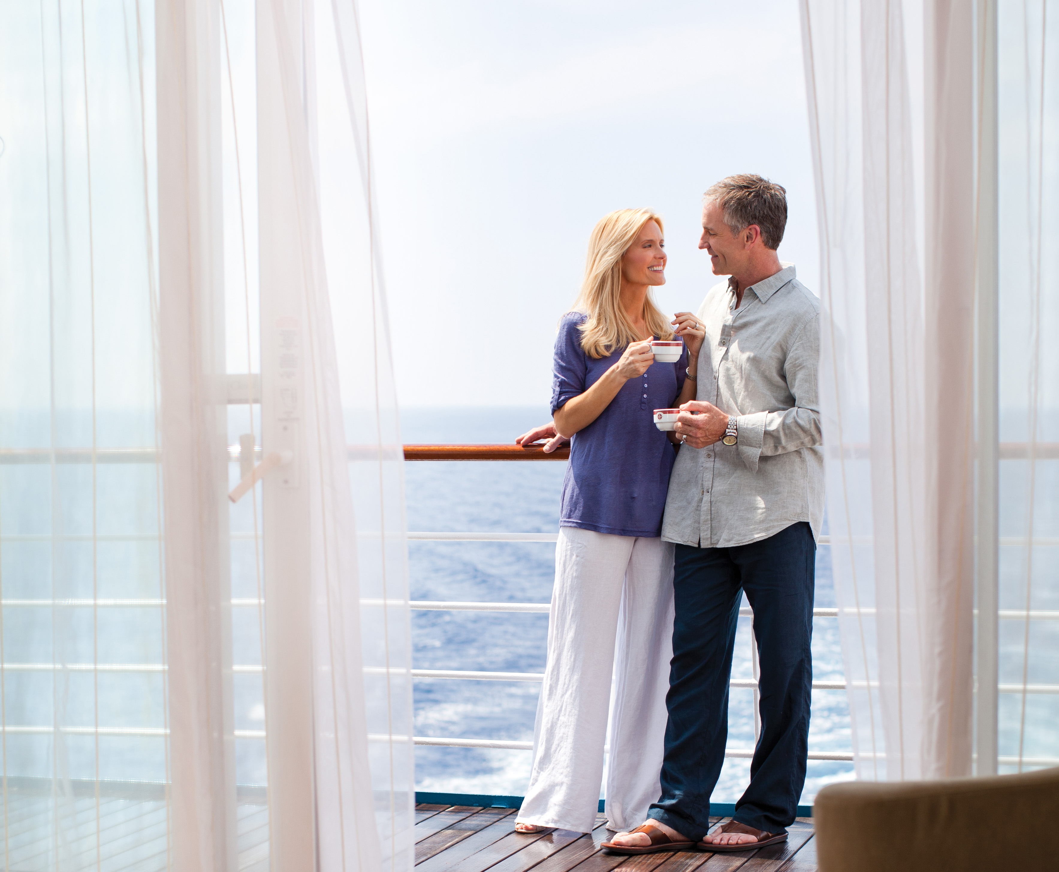
Cruise overview
WHY BOOK WITH US?
- ✔ The Deluxe Cruises’ team has extensive experience in ultra-luxury cruising.
- ✔ Call now to speak to our helpful and experienced Cruise Concierge team.
- ✔ Enjoy our Unique Deluxe Cruises Bonus for substantial savings.
- ✔ Our team will tailor your holiday to your exacting requirements.
- ✔ As agents, we work under the protection of each cruise lines ABTA / ATOL licences
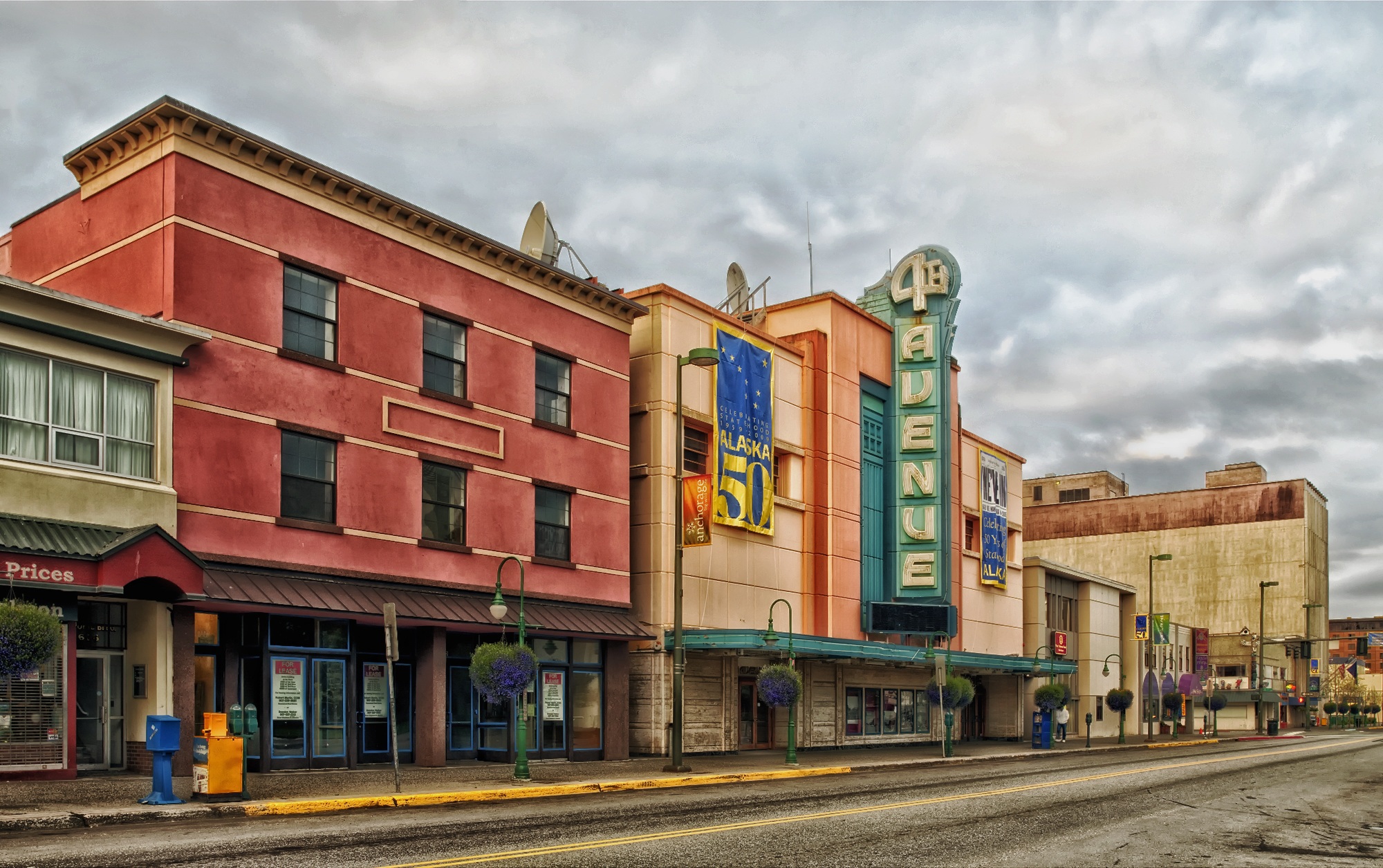
About Anchorage, Alaska
Anchorage is the largest city in Alaska. Located between mountains, it is a beautiful mixture of urban and wilderness. Thanks to its proximity to the Chugach State Park with its 45 species of mammals and the city's rich history, there is so much to be seen in this unique destination.


About Sitka, Alaska
It's hard not to like Sitka, with its eclectic blend of Alaska Native, Russian, and American history and its dramatic and beautiful open-ocean setting. This is one of the best Inside Passage towns to explore on foot, with St. Michael's Cathedral, Sheldon Jackson Museum, Castle Hill, Sitka National Historical Park, and the Alaska Raptor Center topping the must-see list.Sitka was home to the Kiksádi clan of the Tlingit people for centuries prior to the 18th-century arrival of the Russians under the direction of territorial governor Alexander Baranof, who believed the region was ideal for the fur trade. The governor also coveted the Sitka site for its beauty, mild climate, and economic potential; in the island's massive timber forests he saw raw materials for shipbuilding. Its location offered trading routes as far west as Asia and as far south as California and Hawaii. In 1799 Baranof built St. Michael Archangel—a wooden fort and trading post 6 miles north of the present town.Strong disagreements arose shortly after the settlement. The Tlingits attacked the settlers and burned their buildings in 1802. Baranof, however, was away in Kodiak at the time. He returned in 1804 with a formidable force—including shipboard cannons—and attacked the Tlingits at their fort near Indian River, site of the present-day 105-acre Sitka National Historical Park, forcing many of them north to Chichagof Island.By 1821 the Tlingits had reached an accord with the Russians, who were happy to benefit from the tribe's hunting skills. Under Baranof and succeeding managers, the Russian-American Company and the town prospered, becoming known as the Paris of the Pacific. The community built a major shipbuilding and repair facility, sawmills, and forges, and even initiated an ice industry, shipping blocks of ice from nearby Swan Lake to the booming San Francisco market. The settlement that was the site of the 1802 conflict is now called Old Sitka. It is a state park and listed as a National Historic Landmark.The town declined after its 1867 transfer from Russia to the United States, but it became prosperous again during World War II, when it served as a base for the U.S. effort to drive the Japanese from the Aleutian Islands. Today its most important industries are fishing, government, and tourism.

About Klawock, Alaska
Klawock is a city in Prince of Wales–Hyder Census Area, in the U.S. state of Alaska, on the west coast of Prince of Wales Island, on Klawock Inlet, across from Klawock Island. The population was 755 at the 2010 census, down from 854 in 2000.

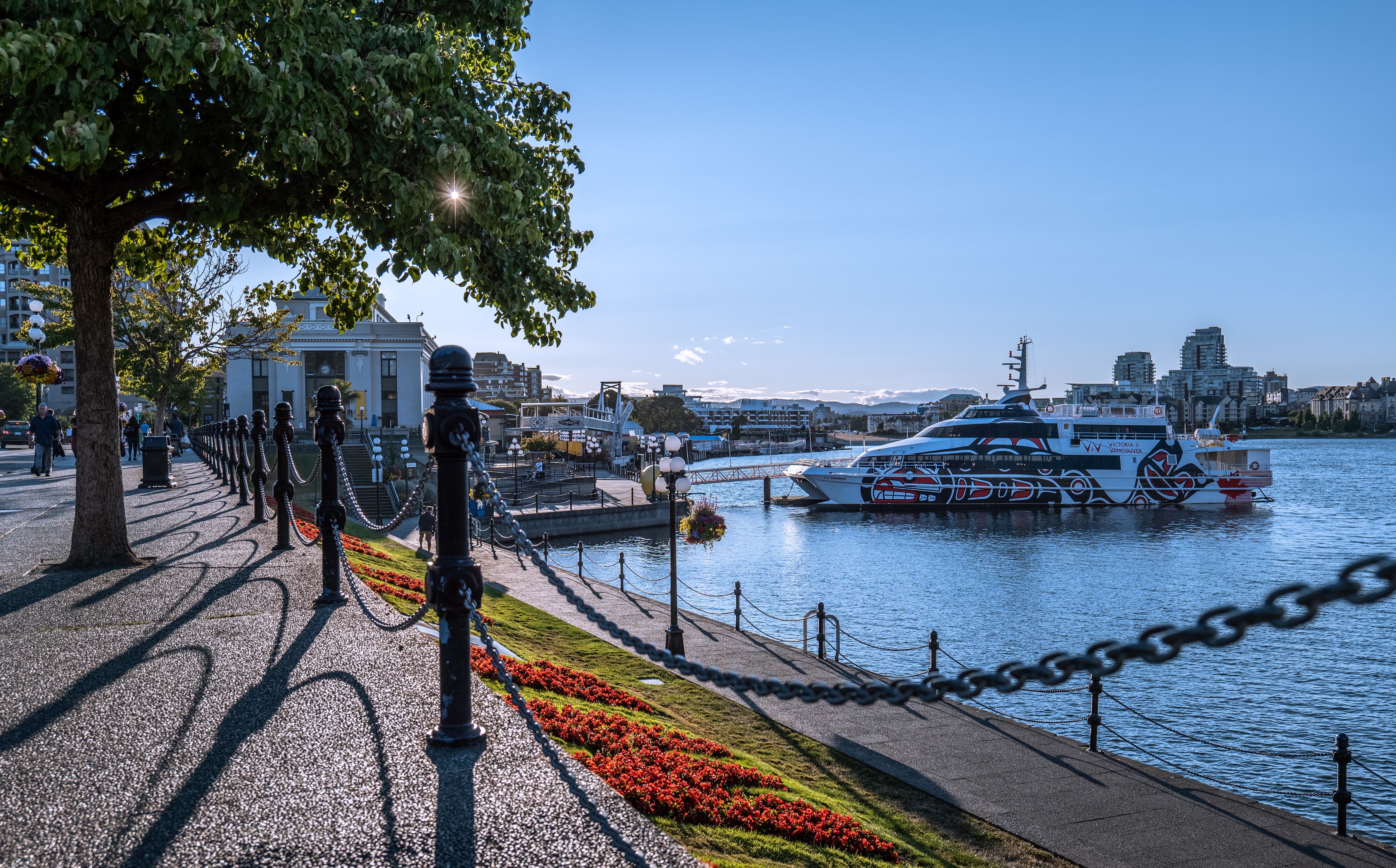
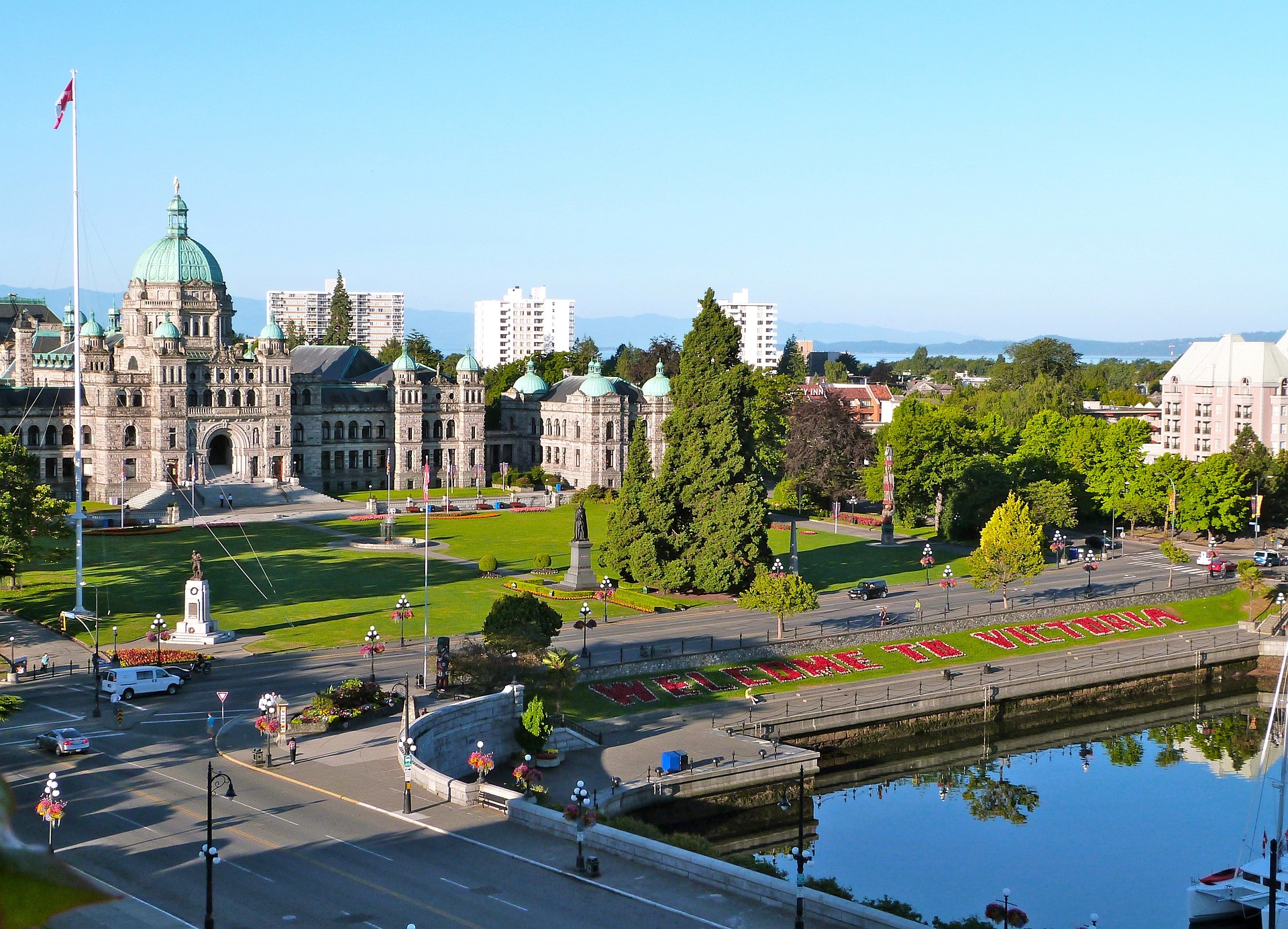
About Victoria, British Columbia
Victoria, the capital of a province whose license plates brazenly label it "The Best Place on Earth," is a walkable, livable seaside city of fragrant gardens, waterfront paths, engaging museums, and beautifully restored 19th-century architecture. In summer, the Inner Harbour—Victoria's social and cultural center—buzzes with visiting yachts, horse-and-carriage rides, street entertainers, and excursion boats heading out to visit pods of friendly local whales. Yes, it might be a bit touristy, but Victoria's good looks, gracious pace, and manageable size are instantly beguiling, especially if you stand back to admire the mountains and ocean beyond. At the southern tip of Vancouver Island, Victoria dips slightly below the 49th parallel. That puts it farther south than most of Canada, giving it the mildest climate in the country, with virtually no snow and less than half the rain of Vancouver. The city's geography, or at least its place names, can cause confusion. Just to clarify: the city of Victoria is on Vancouver Island (not Victoria Island). The city of Vancouver is on the British Columbia mainland, not on Vancouver Island. At any rate, that upstart city of Vancouver didn't even exist in 1843 when Victoria, then called Fort Victoria, was founded as the westernmost trading post of the British-owned Hudson's Bay Company. Victoria was the first European settlement on Vancouver Island, and in 1868 it became the capital of British Columbia. The British weren't here alone, of course. The local First Nations people—the Songhees, the Saanich, and the Sooke—had already lived in the areas for thousands of years before anyone else arrived. Their art and culture are visible throughout southern Vancouver Island. You can see this in private and public galleries, in the totems at Thunderbird Park, in the striking collections at the Royal British Columbia Museum, and at the Quw'utsun'Cultural and Conference Centre in nearby Duncan. Spanish explorers were the first foreigners to explore the area, although they left little more than place names (Galiano Island and Cordova Bay, for example). The thousands of Chinese immigrants drawn by the gold rushes of the late 19th century had a much greater impact, founding Canada's oldest Chinatown and adding an Asian influence that's still quite pronounced in Victoria's multicultural mix. Despite its role as the provincial capital, Victoria was largely eclipsed, economically, by Vancouver throughout the 20th century. This, as it turns out, was all to the good, helping to preserve Victoria's historic downtown and keeping the city largely free of skyscrapers and highways. For much of the 20th century, Victoria was marketed to tourists as "The Most British City in Canada," and it still has more than its share of Anglo-themed pubs, tea shops, and double-decker buses. These days, however, Victorians prefer to celebrate their combined indigenous, Asian, and European heritage, and the city's stunning wilderness backdrop. Locals do often venture out for afternoon tea, but they're just as likely to nosh on dim sum or tapas. Decades-old shops sell imported linens and tweeds, but newer upstarts offer local designs in hemp and organic cotton. And let's not forget that fabric prevalent among locals: Gore-Tex. The outdoors is ever present here. You can hike, bike, kayak, sail, or whale-watch straight from the city center, and forests, beaches, offshore islands, and wilderness parklands lie just minutes away. A little farther afield, there's surfing near Sooke, wine touring in the Cowichan Valley, and kayaking among the Gulf Islands.
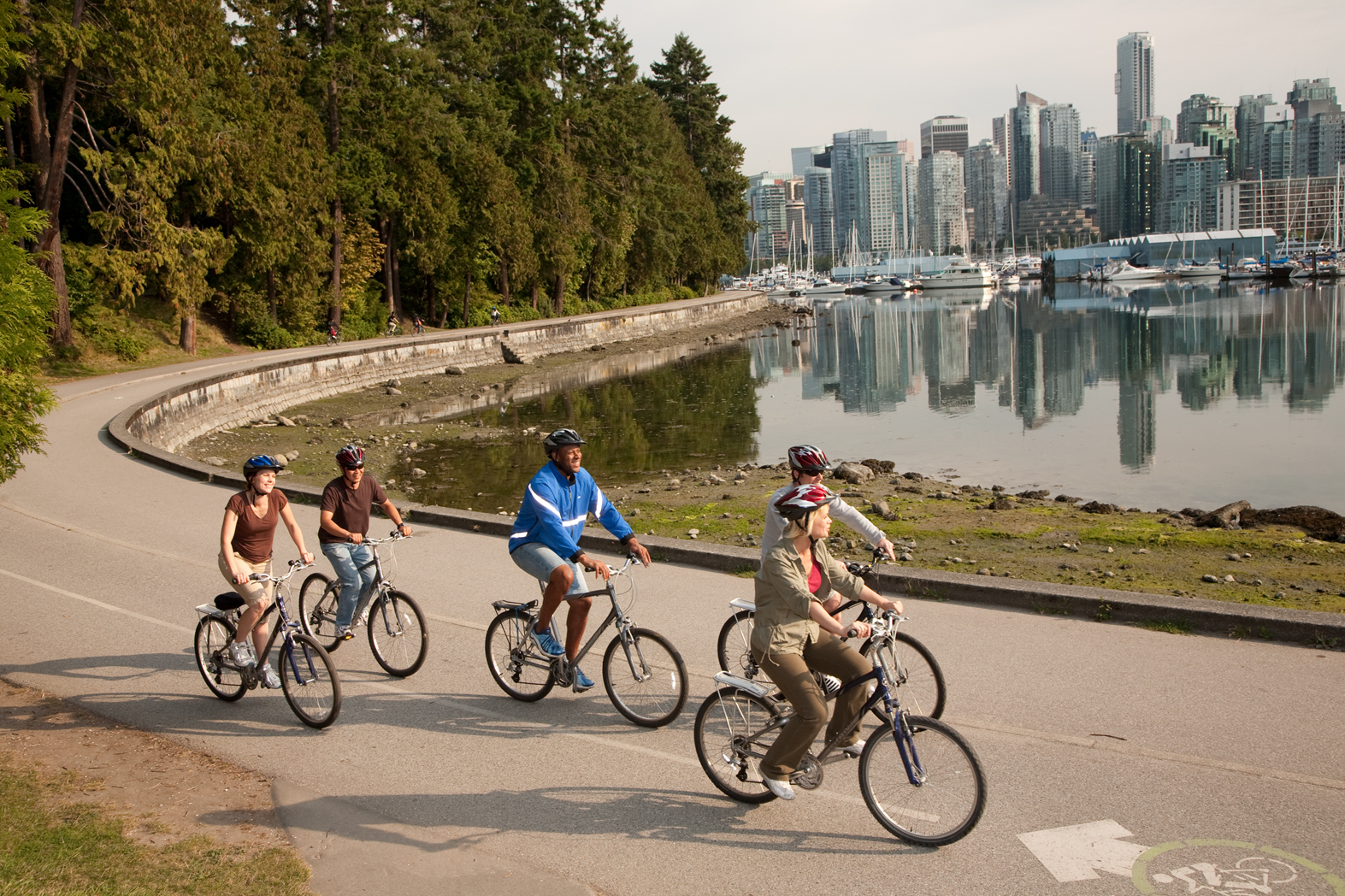
About Vancouver, British Columbia
Vancouver is a delicious juxtaposition of urban sophistication and on-your-doorstep wilderness adventure. The mountains and seascape make the city an outdoor playground for hiking, skiing, kayaking, cycling, and sailing—and so much more—while the cuisine and arts scenes are equally diverse, reflecting the makeup of Vancouver's ethnic (predominantly Asian) mosaic. Vancouver is consistently ranked as one of the world's most livable cities, and it's easy for visitors to see why. It's beautiful, it's outdoorsy, and there's a laidback West Coast vibe. On the one hand, there's easy access to a variety of outdoor activities, a fabulous variety of beaches, and amazing parks. At the same time, the city has a multicultural vitality and cosmopolitan flair. The attraction is as much in the range of food choices—the fresh seafood and local produce are some of North America's best—as it is in the museums, shopping, and nightlife.Vancouver's landscaping also adds to the city's walking appeal. In spring, flowerbeds spill over with tulips and daffodils while sea breezes scatter scented cherry blossoms throughout Downtown; in summer office workers take to the beaches, parks, and urban courtyards for picnic lunches and laptop meetings. More than 8 million visitors each year come to Vancouver, Canada's third-largest metropolitan area. Because of its peninsula location, traffic flow is a contentious issue. Thankfully, Vancouver is wonderfully walkable, especially in the downtown core. The North Shore is a scoot across the harbor, and the rapid-transit system to Richmond and the airport means that staying in the more affordable ’burbs doesn't have to be synonymous with sacrificing convenience. The mild climate, exquisite natural scenery, and relaxed outdoor lifestyle keep attracting residents, and the number of visitors is increasing for the same reasons. People often get their first glimpse of Vancouver when catching an Alaskan cruise, and many return at some point to spend more time here.

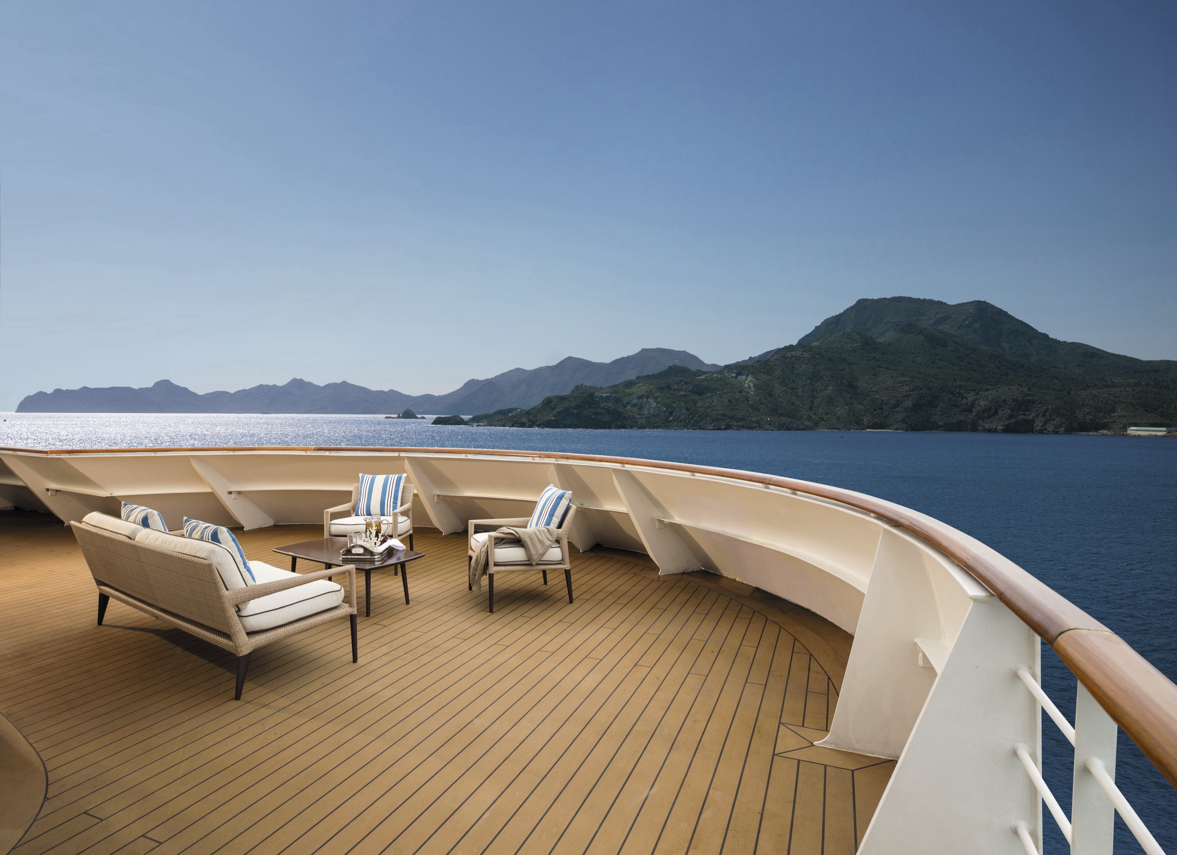
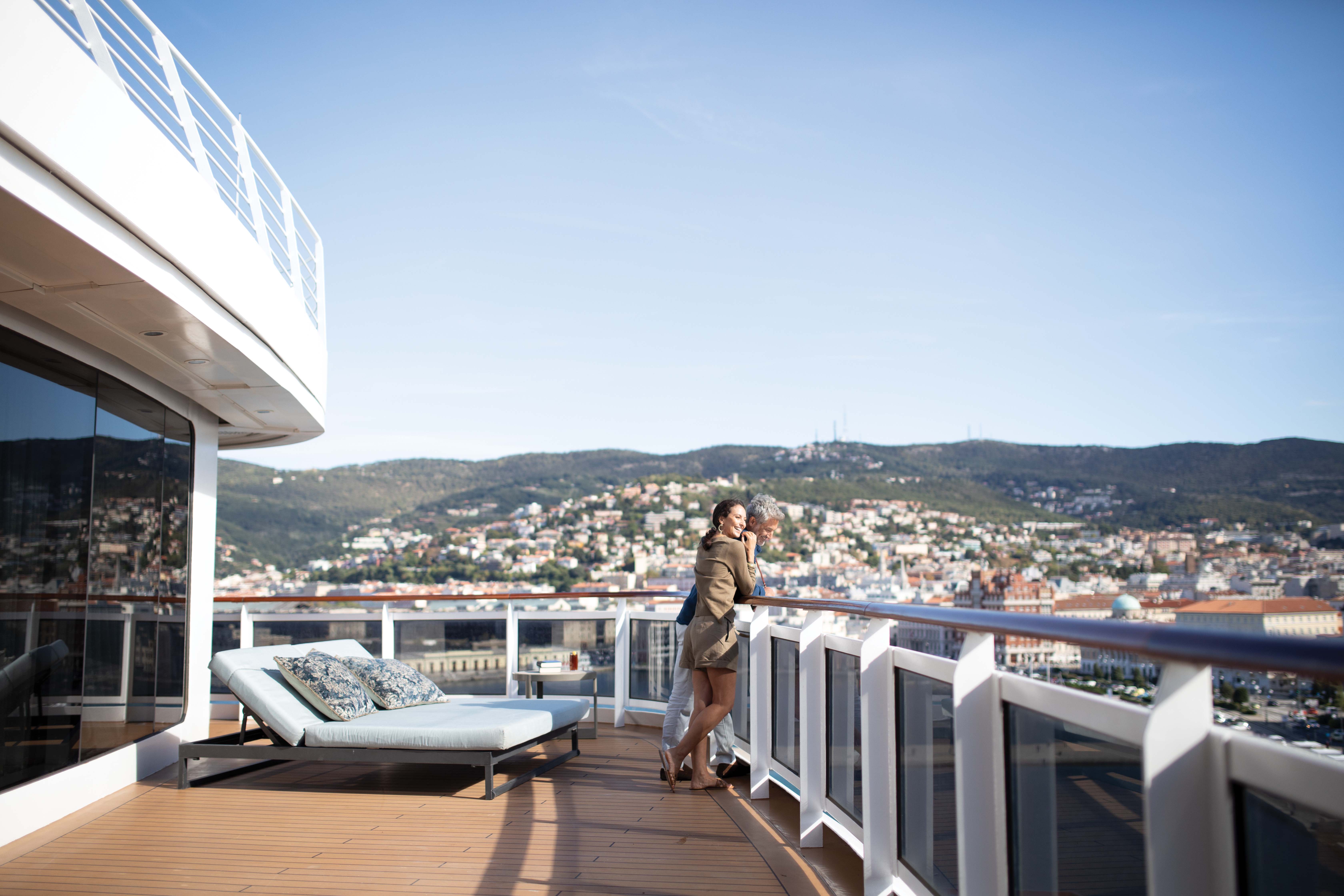
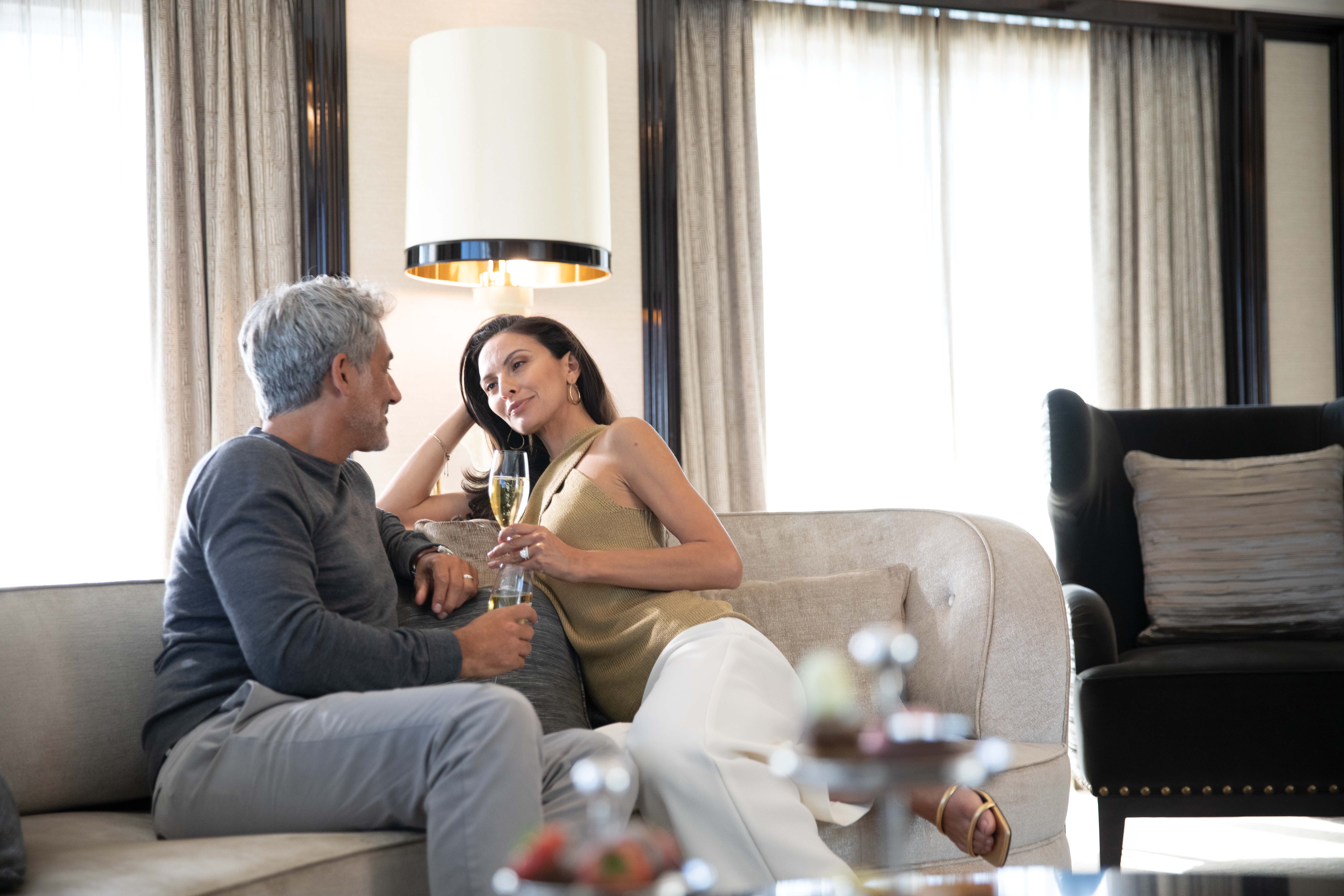
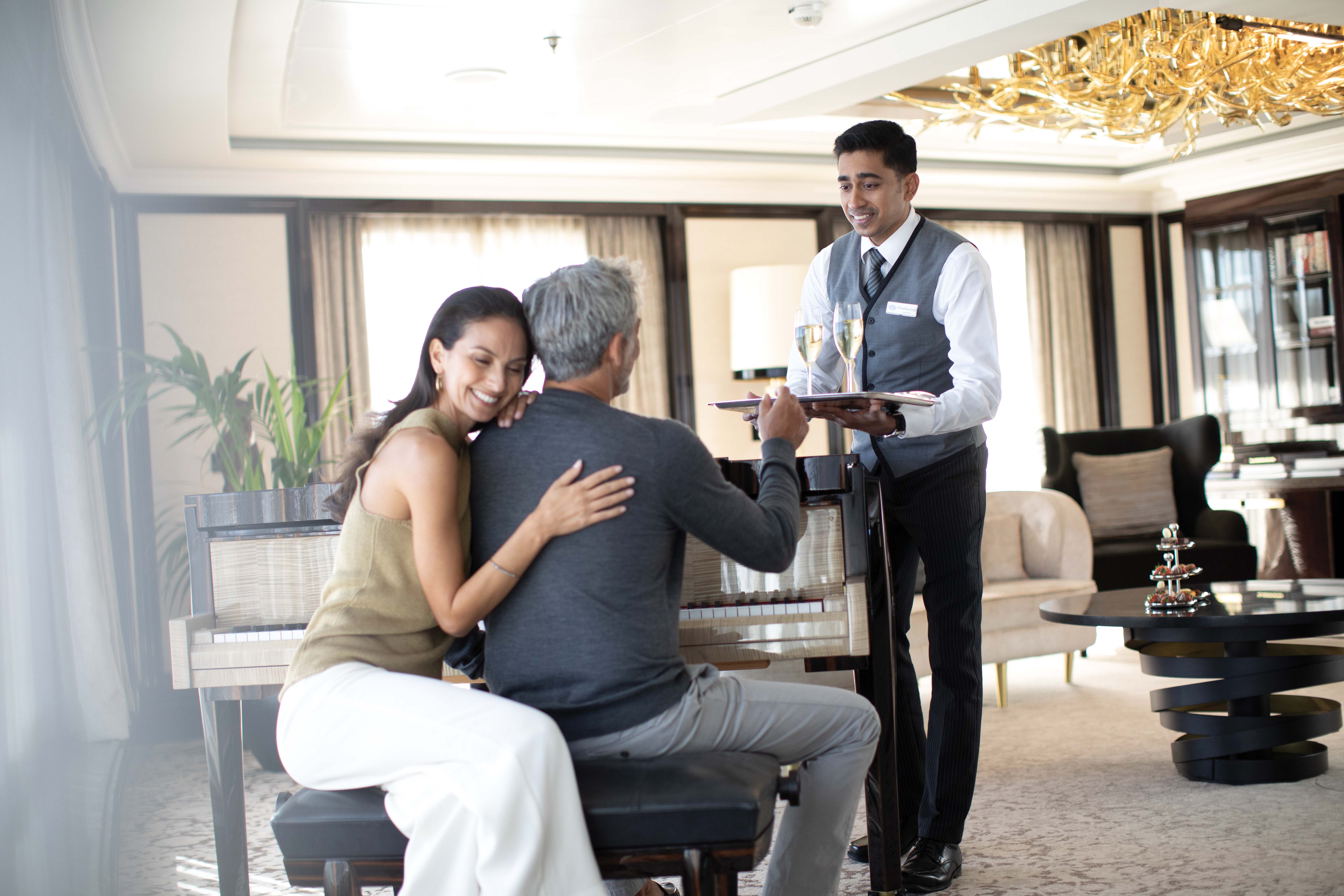
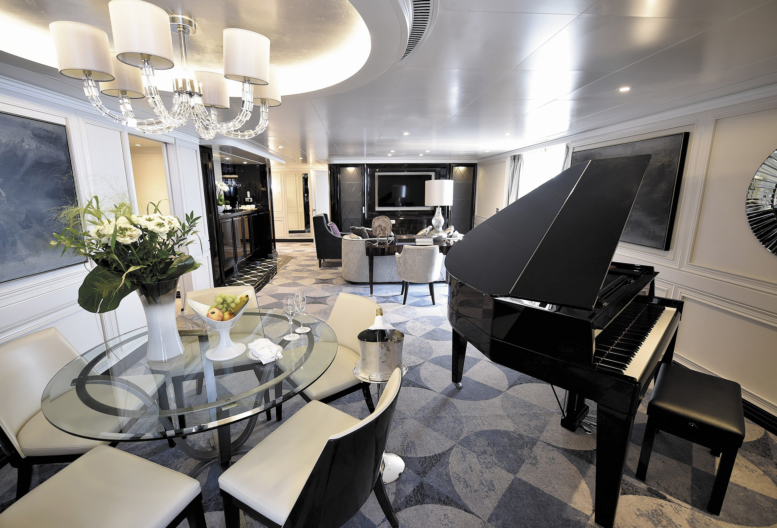
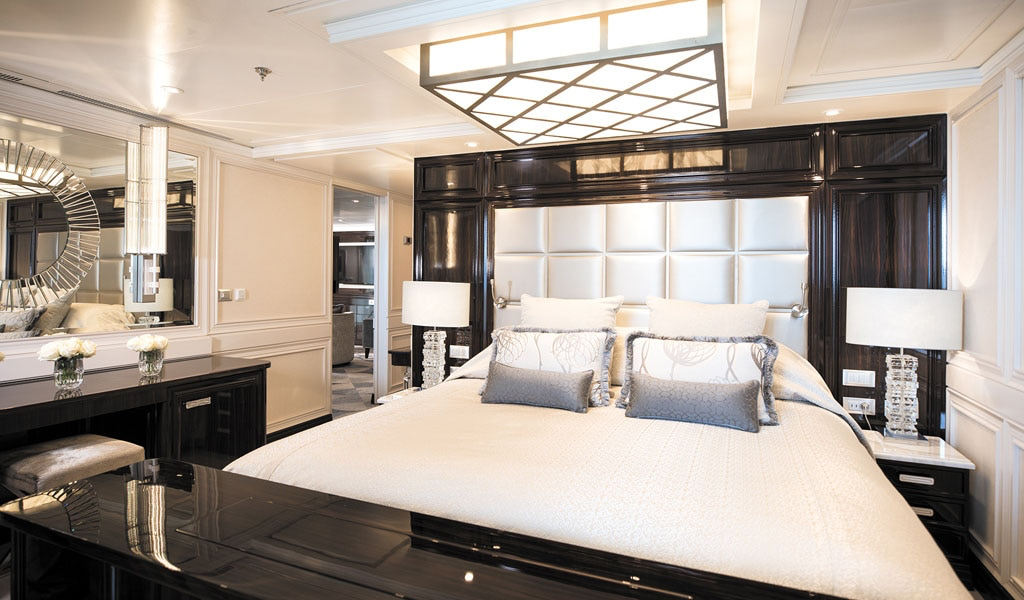
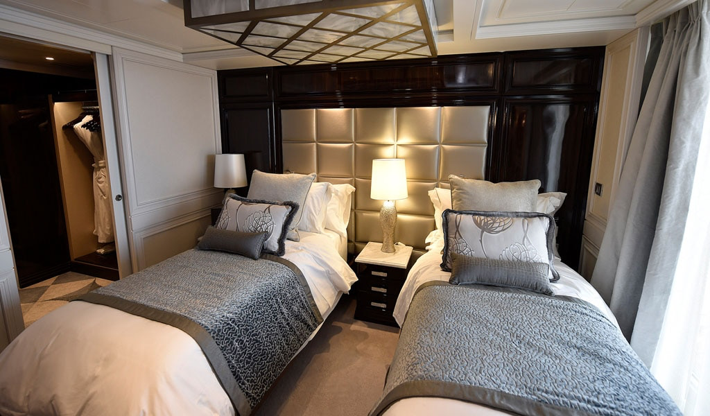
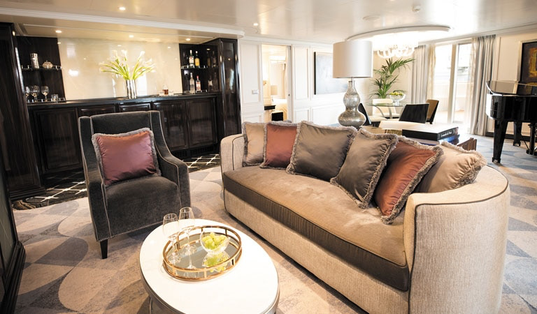
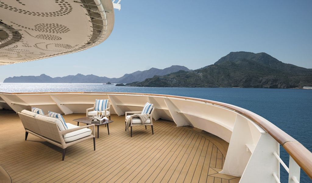
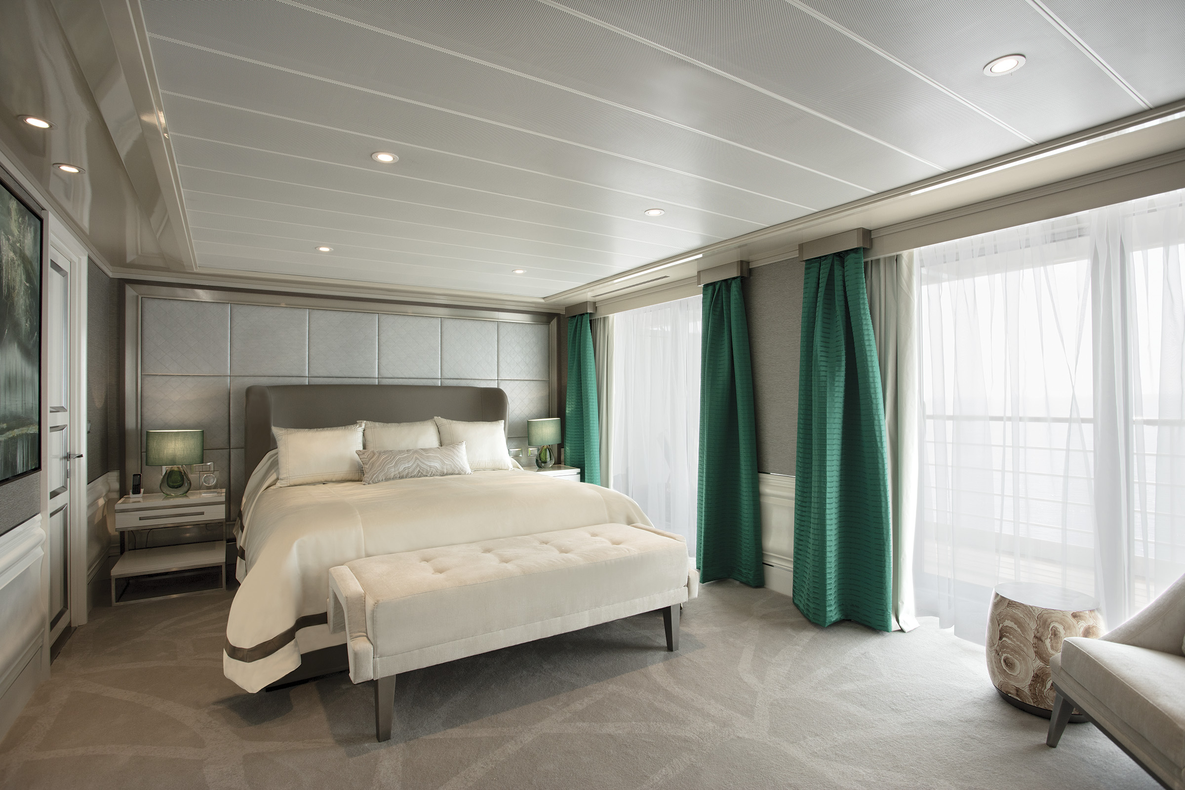
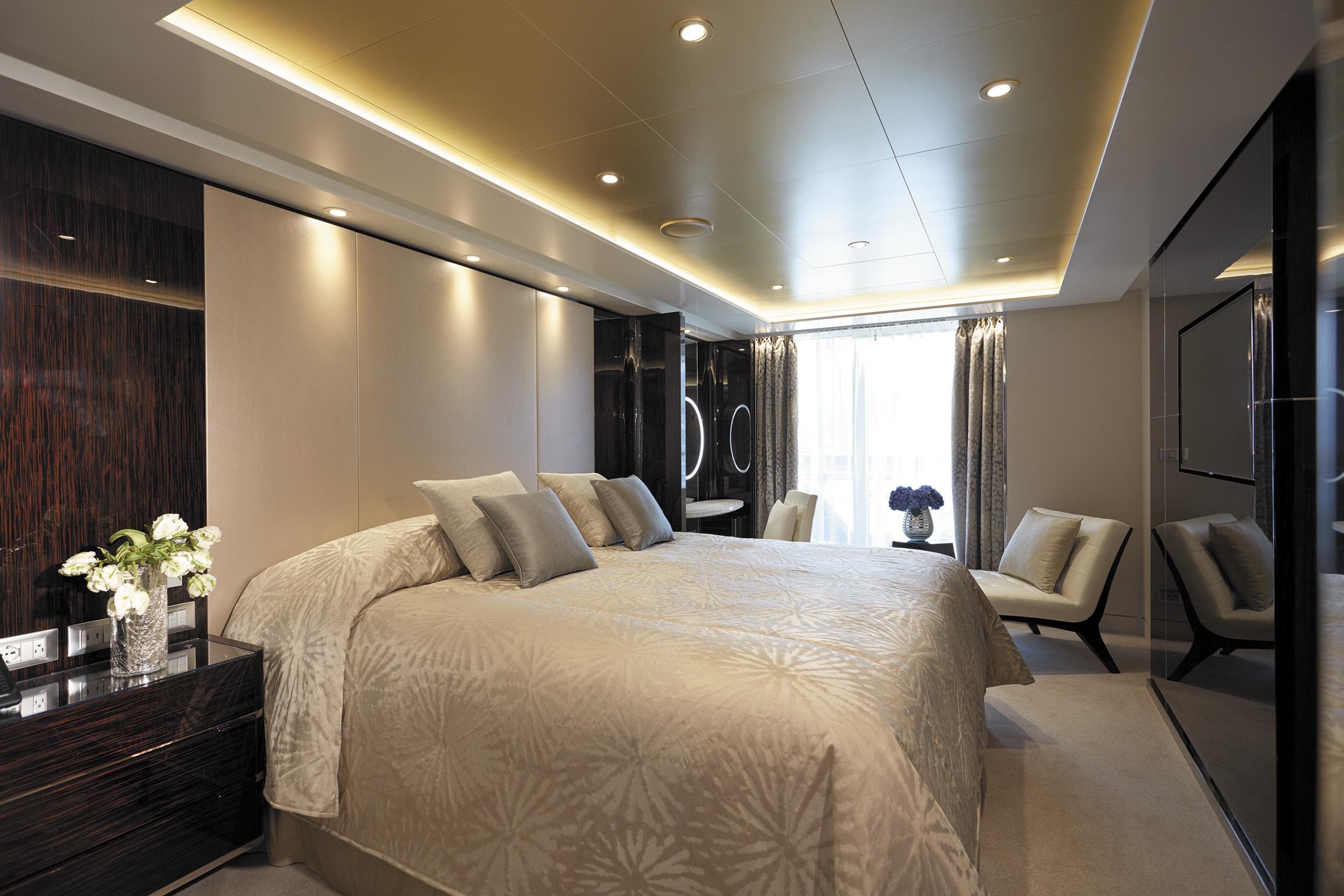
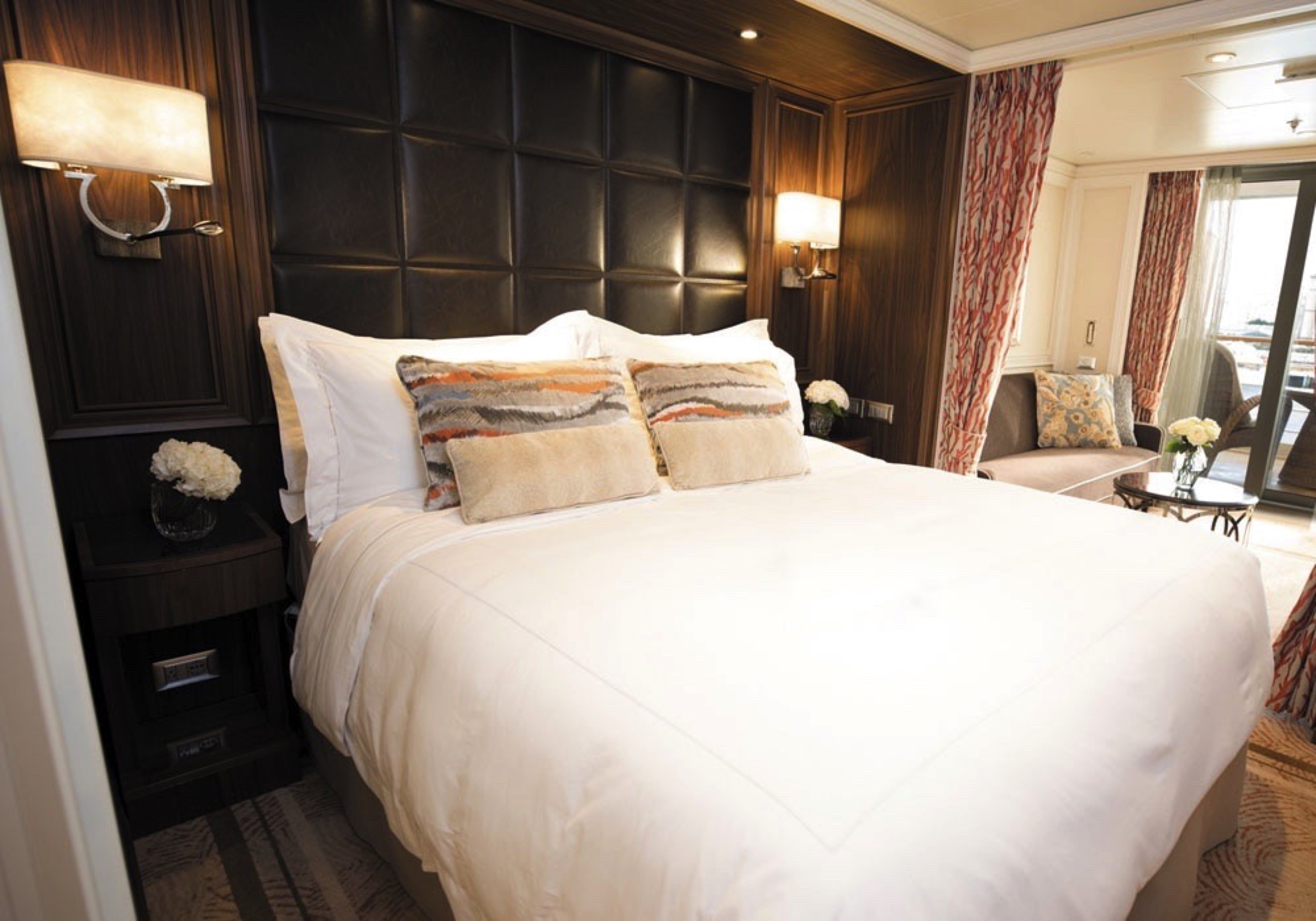
Incomparable craftsmanship and meticulous attention to detail are evident everywhere – from the suite’s unique design choices, such as rare works of art, to grand features like an in-suite spa retreat and Steinway piano. The only thing to rival the luxurious interior that includes two magnificent bedrooms is the spectacular ocean view from private balconies that include a Tresse Minipool high atop the ship.
LAYOUT
- 2 Spacious Bedrooms with King-Size Savoir Bed with Mollissima Duvet in Primary Bedroom (*Bed in primary bedroom cannot be converted into two beds.)
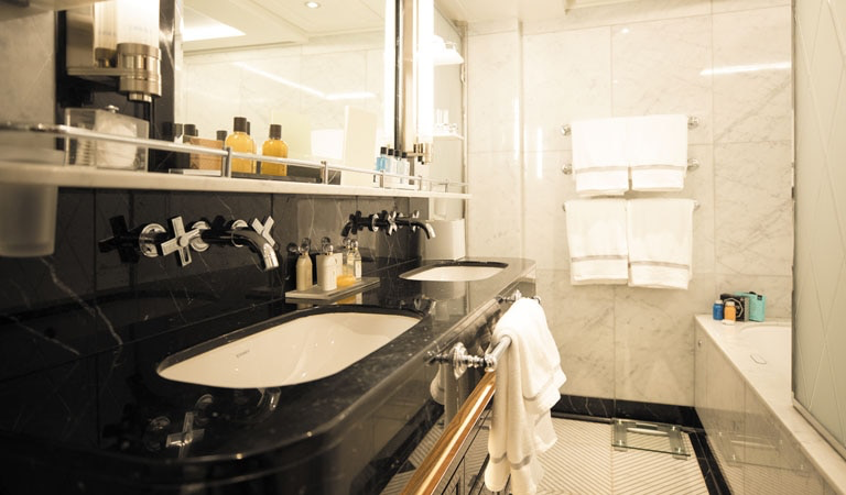
- 2 1/2 Marble & Stone Detailed Bathrooms, 1 with Jetted Tub
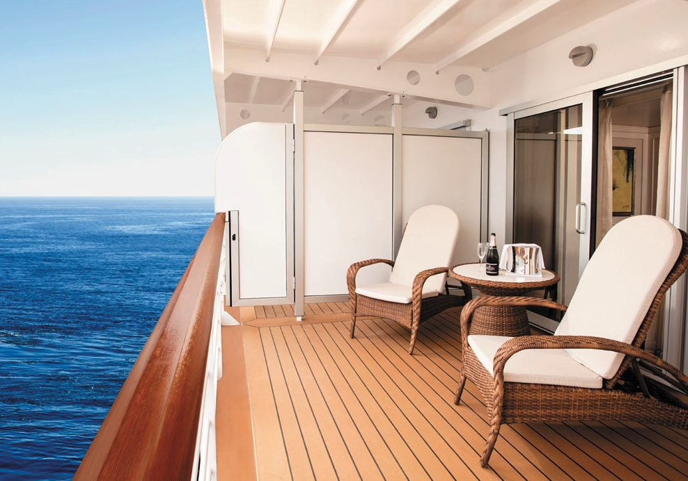
- 2 Private Balconies with Heated Minipool Spa
- Private In-Suite Spa with Sauna, Steam Room & Jacuzzi
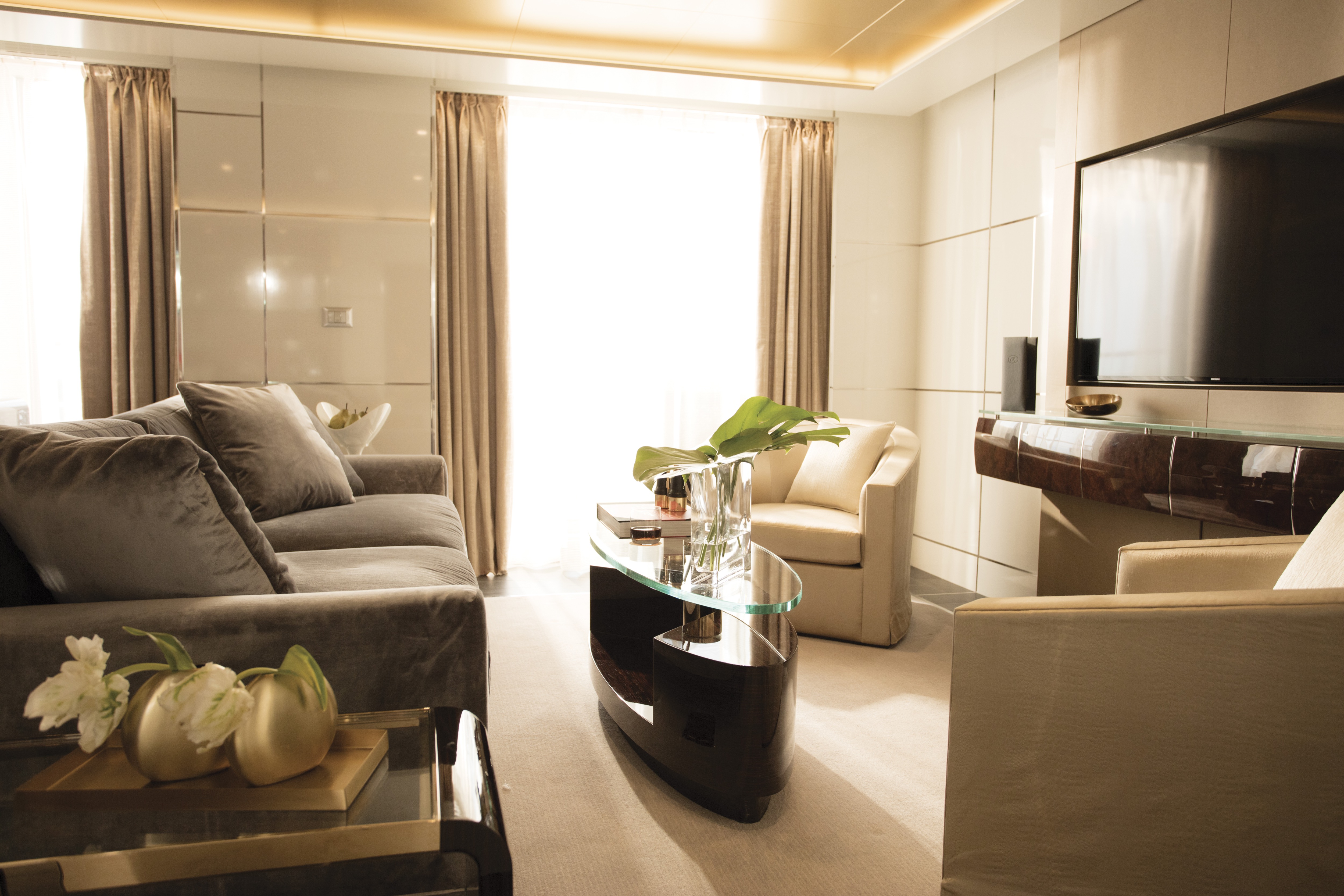
- Spacious Living Room
- Private Solarium
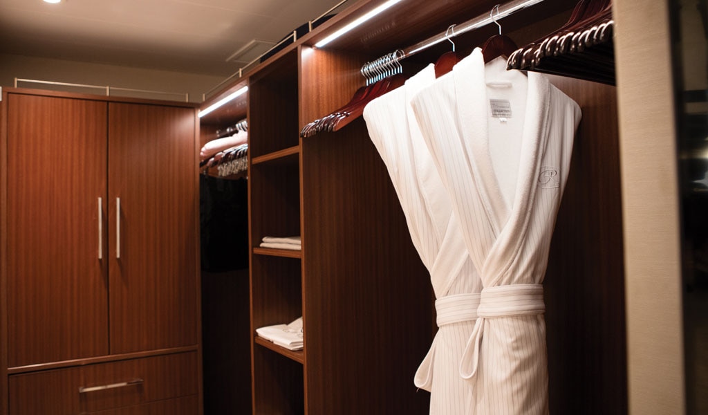
- 3 Walk-In Closets with 2 Safes
- Custom Steinway Grand Baroque Piano by Dakota Jackson
- Private, Separately Located Dining Room for Up to 12 Guests
- Includes Up To 6 Guests
The suite pictured may differ from the suite booked, as layouts and designs vary by ship, deck, and suite location.
AMENITIES- 1-Night Pre-Cruise: Hotel Package Including:
- - Ground Transfers
- - Breakfast
- - Porterage
- Unlimited WiFi and Streaming Package for up to Four Devices
- Valet Laundry Service
- 24-hour In-Suite Dining
- Fresh Orchid Arrangement
- L'Occitane® Jasmin & Bergamot Bath Amenities
- Regent Plush Bathrobe & Slippers
- Interactive Flat-Screen Television & Direct-Dial Satellite Phone
- Priority Access to Online Shore Excursion Reservations
- Priority Access to Online Dining Reservations
- Binoculars
- illy® Espresso Maker
- Cashmere Blankets
- Regent Special Gift
- Vanity & Hair Dryer
- Shoe Shine Service
- Additional Discounts:
- - 10% Discount on Ultra Premium Wine and Liquor
- - 5% Savings on Pre- or Post-Cruise Hotel or Land Programs
- - 5% Savings on Regent Choice Shore Excursions
- Additional Regent Suites Amenities:
- Personal Car & Guide to Explore Ashore
- Daily Serene Spa & Wellness™ Services with Priority Reservations
- Access to The Study, a Private Dining Room for up to 12 Guests
- Unlimited Dry Cleaning
- VIP Status Including Dinner with a Senior Officer
- Guaranteed Reservation Each Night in Specialty Restaurant of Your Choice
- Welcome Letter from the President and General Manager
- Personal Butler for an Elevated In-suite Experience
- - In-Suite Dining Menu Including Specialty Restaurant Selections During Dining Hours
- Priority Boarding on Embarkation Day with Suite Access at Noon
- Welcome Bottle of Dom Pérignon Champagne
- Remy Martin Louis XIII Cognac 50ml
- Personalized In-Suite Full-Liquor Bar Set-Up
- A Sumptuous In-Suite Caviar Service Once During Cruises
- Complimentary In-Suite Cocktail Party for 8
- Complimentary 25-Minute Personal Fitness Session at the Serene Spa & Wellness™ Fitness Center
- Daily Canapés
- Tea Forté Set-Up
- Luxe Fruit Arrangement with Chocolate Leonidas
- Choice of Luxurious Designer Bath Amenities
- Spa Accessories & Spongology Collection
- Guerlain Box with Fragrance & Spongellé Buffer
- Dyson Hairdryer
- Selection of Fig & Tea Leaves Bath Salts
- Guerlain Bath Amenities & Men's Unscented Shaving Kit
- Bath Scale Setup
- Wallet Make Up Brush Set / Hairbrush & Combo Set
- Bose® SoundLink Mini II Bluetooth Speaker
- Selection of Bed Pillow Styles
- Linen Menu
- Complimentary Garment Pressing on First Night
- Personalized Stationery upon request
- Elegant Weather Clock
- Excursion Bag

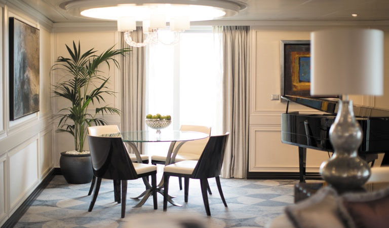
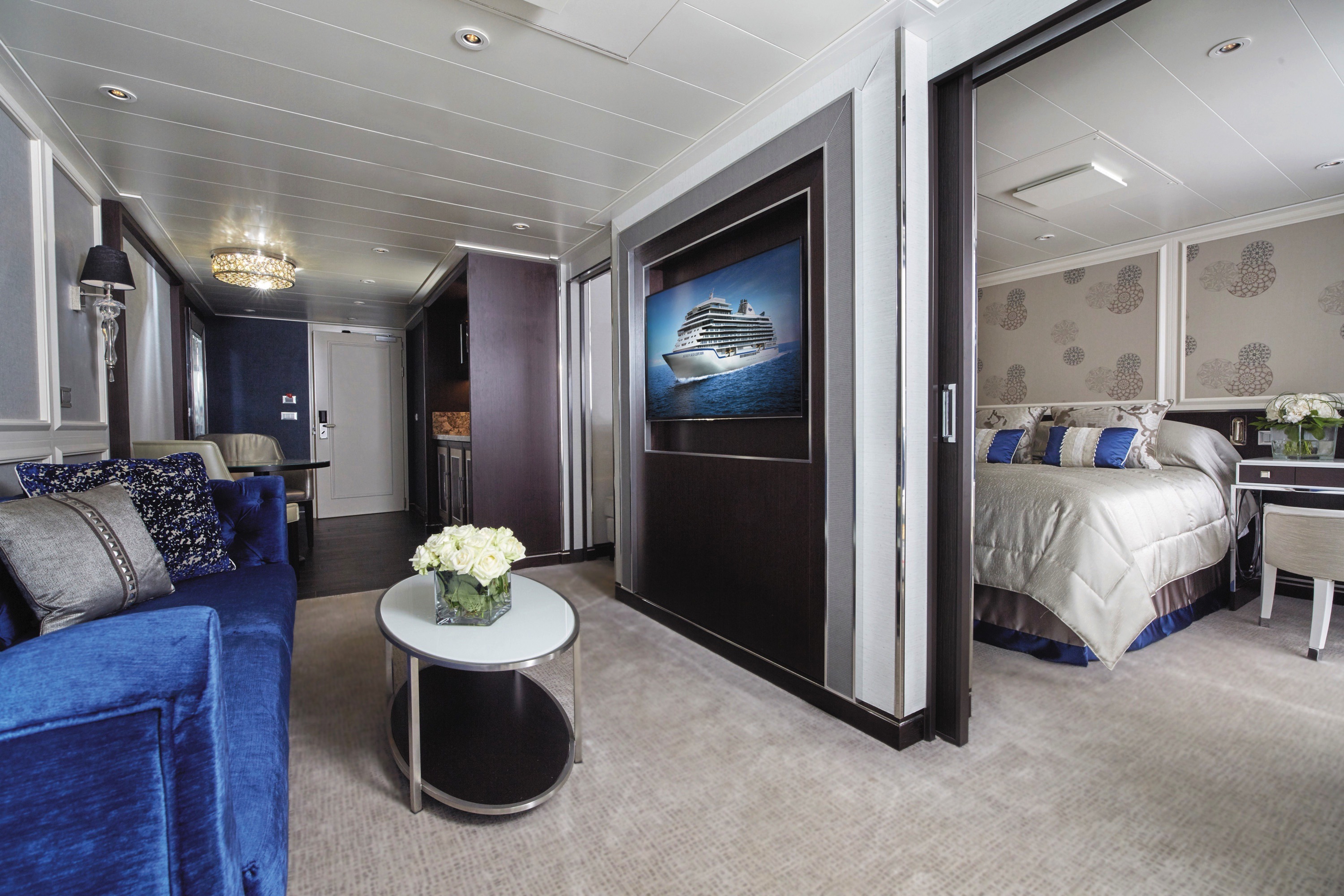
You’ll find Park Avenue chic onboard Seven Seas Explorer® in this extravagant, stylish suite. A rich color palette, the finest fabrics and a grand piano create sophisticated comfort, while a personal butler will happily assist with both ordinary and special requests. With two spacious bedrooms, two-and-a-half baths, a large living room and a wrap-around private balcony, this suite is perfectly suited to host gatherings of new friends.
Layout
- 2 Spacious Bedroom with a European King-Size Elite Slumber® Bed (*Bed in primary bedroom cannot be converted into two beds.)
- 2 Marble & Stone Detailed Bathrooms
- Private Balcony
- Sitting Area
- Walk-In Closet with Safe
- Includes Up To 6 Guests
The suite pictured may differ from the suite booked, as layouts and designs vary by ship, deck, and suite location.
Amenities
- 1-Night Pre-Cruise: Hotel Package Including:
- - Ground Transfers
- - Breakfast
- - Porterage
- Unlimited WiFi and Streaming Package for up to Four Devices
- Valet Laundry Service
- 24-hour In-Suite Dining
- Fresh Orchid Arrangement
- L'Occitane® Jasmin & Bergamot Bath Amenities
- Regent Plush Bathrobe & Slippers
- Interactive Flat-Screen Television & Direct-Dial Satellite Phone
- Priority Access to Online Shore Excursion Reservations
- Priority Access to Online Dining Reservations
- Binoculars
- illy® Espresso Maker
- Cashmere Blankets
- Regent Special Gift
- Vanity & Hair Dryer
- Shoe Shine Service
- Additional Discounts:
- - 10% Discount on Ultra Premium Wine and Liquor
- - 5% Savings on Pre- or Post-Cruise Hotel or Land Programs
- - 5% Savings on Regent Choice Shore ExcursionsAdditional Signature Suite Amenities:
- VIP Status Including Dinner with a Senior Officer
- Guaranteed Reservation Each Night in Specialty Restaurant of Your Choice
- Welcome Letter from the President and General Manager
- Personal Butler for an Elevated In-suite Experience
- - In-Suite Dining Menu Including Specialty Restaurant Selections During Dining Hours
- Priority Boarding on Embarkation Day with Suite Access at Noon
- Welcome Bottle of Premium Champagne
- Personalized In-Suite Full-Liquor Bar Set-Up
- A Sumptuous In-Suite Caviar Service Once During Cruises
- Complimentary In-Suite Cocktail Party for 8
- Complimentary 25-Minute Personal Fitness Session at the Serene Spa & Wellness™ Fitness Center
- Daily Canapés
- Tea Forté Set-Up
- Luxe Fruit Arrangement with Chocolate Leonidas
- Luxurious Designer Bath Amenities & Men's Unscented Shaving Kit
- Guerlain Box with Fragrance & Spongellé Buffer
- Dyson Hairdryer
- Selection of Fig & Tea Leaves Bath Salts
- Guerlain Bath Amenities & Men's Unscented Shaving Kit
- Bath Scale Setup
- Bose® SoundLink Mini II Bluetooth Speaker
- Selection of Bed Pillow Styles
- Complimentary Garment Pressing on First Night
- Personalized Stationery upon request
- Elegant Weather Clock
- Excursion Bag
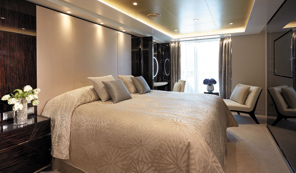
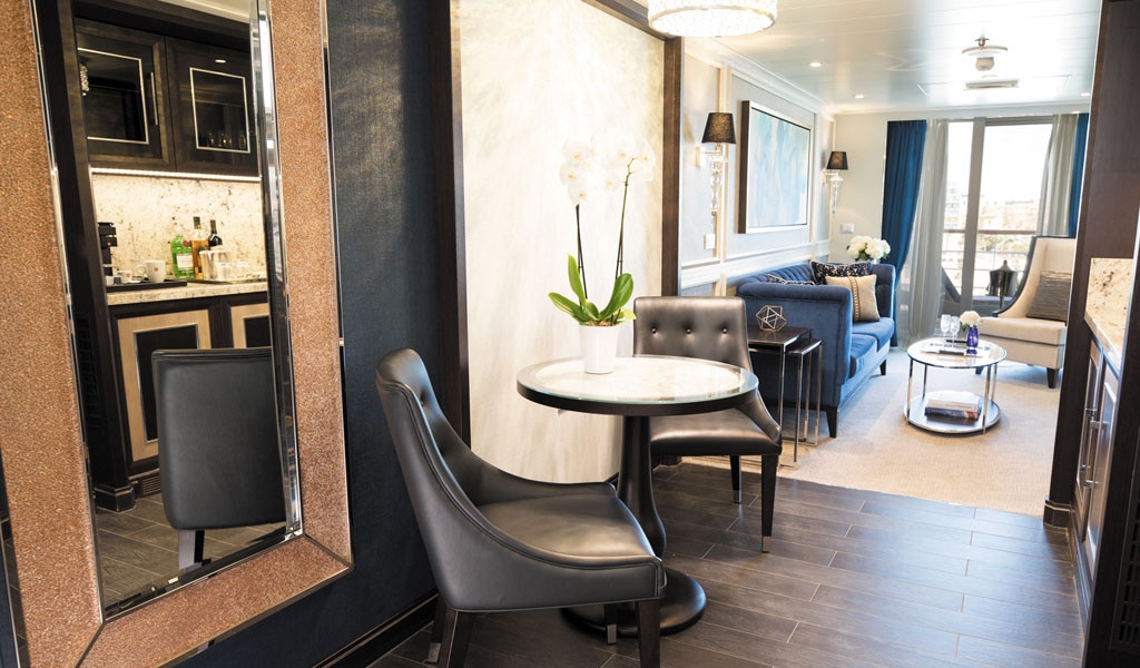
Step into the richness of an emerald green dining area perfectly ensconced within a spacious, sumptuous living room. Just outside is a private balcony with a table and chairs, perfect for in-suite breakfast. The private bedroom is large and inviting, its soothing color palette perfect for a peaceful night's rest on your King-Size Elite Slumber™ Bed. Two full baths make it a perfect space for entertaining new friends on the high seas.
The suite pictured may differ from the suite booked, as layouts and designs vary by ship, deck, and suite location.
Layout
- 1 Spacious Bedroom with a European King-Size Elite Slumber® Bed (*Bed cannot be converted into two beds.)
- 2 Marble & Stone Detailed Bathrooms
- Private Balcony
- Sitting Area
- Walk-In Closet with Safe
- Accommodates Up To 3 Guests
The suite pictured may differ from the suite booked, as layouts and designs vary by ship, deck, and suite location.
Amenities
- 1-Night Pre-Cruise: Hotel Package Including:
- - Breakfast
- - Porterage
- Unlimited WiFi Includes up to Four Logins, Four Devices, per Suite
- Valet Laundry Service
- 24-hour In-Suite Dining
- Fresh Orchid Arrangement
- L'Occitane® Jasmin & Bergamot Bath Amenities
- Regent Plush Bathrobe & Slippers
- Interactive Flat-Screen Television & Direct-Dial Satellite Phone
- Priority Access to Online Shore Excursion Reservations
- Priority Access to Online Dining Reservations
- Binoculars
- illy® Espresso Maker
- Cashmere Blankets
- Regent Special Gift
- Vanity & Hair Dryer
- Shoe Shine Service
- Additional Discounts:
- - 10% Discount on Ultra Premium Wine and Liquor
- - 5% Savings on Pre- or Post-Cruise Hotel or Land Programs
- - 5% Savings on Regent Choice Shore Excursions
Additional Grand Suite Amenities:
- VIP Status Including Dinner with a Senior Officer
- Guaranteed Reservation Each Night in Specialty Restaurant of Your Choice
- Welcome Letter from the President and General Manager
- Personal Butler for an Elevated In-suite Experience
- - In-Suite Dining Menu Including Specialty Restaurant Selections During Dining Hours
- Priority Boarding on Embarkation Day with Suite Access at Noon
- Welcome Bottle of Premium Champagne
- Personalized In-Suite Full-Liquor Bar Set-Up
- A Sumptuous In-Suite Caviar Service Once During Cruises
- Complimentary In-Suite Cocktail Party for 8
- Complimentary 25-Minute Personal Fitness Session at the Serene Spa & Wellness™ Fitness Center
- Daily Canapés
- Tea Forté Set-Up
- Luxe Fruit Arrangement with Chocolate Leonidas
- Luxurious Designer Bath Amenities & Men's Unscented Shaving Kit
- Guerlain Box with Fragrance & Spongellé Buffer
- Dyson Hairdryer
- Selection of Fig & Tea Leaves Bath Salts
- Guerlain Bath Amenities & Men's Unscented Shaving Kit
- Bath Scale Setup
- Bose® SoundLink Mini II Bluetooth Speaker
- Selection of Bed Pillow Styles
- Complimentary Garment Pressing on First Night
- Personalized Stationery upon request
- Elegant Weather Clock
- Excursion Bag
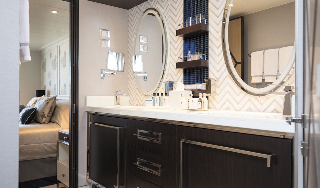
One look at this suite and you’ll be uncorking a bottle of Veuve Clicquot Champagne and toasting your good fortune. A soothing color palette, attention to detail and soothing lighting invite you to unwind in style. The subdued elegance continues with a resplendent private bedroom and one-and-a-half bathrooms, where marble and stone details complement the scents of a variety of lavish soaps, shampoos and lotions.
Layout
- 1 Spacious Bedroom with a European King-Size Elite Slumber® Bed (*Bed cannot be converted into two beds.)
- 1 1/2 Marble & Stone Detailed Bathrooms
- Private Balcony
- Sitting Area
- Walk-In Closet with Safe
- Accommodates Up To 3 Guests
The suite pictured may differ from the suite booked, as layouts and designs vary by ship, deck, and suite location.
Amenities
- 1-Night Pre-Cruise: Hotel Package Including:
- - Ground Transfers
- - Breakfast
- - Porterage
- Unlimited WiFi Includes up to Four Logins, Four Devices, per Suite
- Valet Laundry Service
- 24-hour In-Suite Dining
- Fresh Orchid Arrangement
- L'Occitane® Jasmin & Bergamot Bath Amenities
- Regent Plush Bathrobe & Slippers
- Interactive Flat-Screen Television & Direct-Dial Satellite Phone
- Priority Access to Online Shore Excursion Reservations
- Priority Access to Online Dining Reservations
- Binoculars
- illy® Espresso Maker
- Cashmere Blankets
- Regent Special Gift
- Vanity & Hair Dryer
- Shoe Shine Service
- Additional Discounts:
- - 10% Discount on Ultra Premium Wine and Liquor
- - 5% Savings on Pre- or Post-Cruise Hotel or Land Programs
Additional Explorer Suite Amenities:
- Welcome Letter from the President and General Manager
- Personal Butler for an Elevated In-suite Experience
- - In-Suite Dining from Compass Rose
- Priority Boarding on Embarkation Day with Suite Access at 1pm
- Welcome Bottle of Premium Champagne
- Personalized In-Suite Full-Liquor Bar Set-Up
- A Sumptuous In-Suite Caviar Service Once During Cruises
- Daily Canapés
- Luxe Fruit Arrangement
- Luxurious Designer Bath Amenities & Men's Unscented Shaving Kit
- Selection of Fig & Tea Leaves Bath Salts
- Guerlain Bath Amenities & Men's Unscented Shaving Kit
- Bath Scale Setup
- Bose® SoundLink Mini II Bluetooth Speaker
- Selection of Bed Pillow Styles
- Complimentary Garment Pressing on First Night
- Personalized Stationery upon request
- Elegant Weather Clock
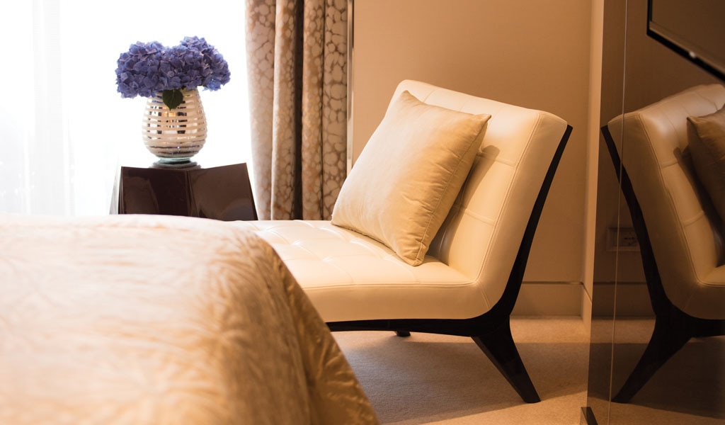
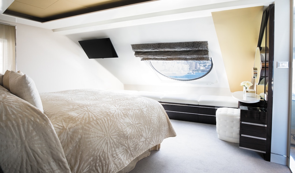
This suite welcomes you with soothing colors, pleasing artwork and comfortable furnishings. Relax in the sitting area after an exciting day ashore and enjoy the selection of fresh canapés delivered by your personal butler. Then retreat to your private balcony to watch the ever-changing vistas and ponder your next destination. Layout
- 1 Spacious Bedroom with a European King-Size Elite Slumber® Bed (*Bed cannot be converted into two beds.)
- 1 Marble & Stone Detailed Bathroom
- Private Balcony
- Sitting Area
- Walk-In Closet with Safe
- Accommodates Up To 3 Guests
The suite pictured may differ from the suite booked, as layouts and designs vary by ship, deck, and suite location.
Amenities
- 1-Night Pre-Cruise: Hotel Package Including:
- - Ground Transfers
- - Breakfast
- - Porterage
- Unlimited WiFi Includes up to Four Logins, Four Devices, per Suite
- Valet Laundry Service
- Customizable In-Suite Mini Bar Replenished Daily with Your Preferences
- 24-hour In-Suite Dining
- Fresh Orchid Arrangement
- L'Occitane® Jasmin & Bergamot Bath Amenities
- Regent Plush Bathrobe & Slippers
- Interactive Flat-Screen Television & Direct-Dial Satellite Phone
- Priority Access to Online Shore Excursion Reservations
- Priority Access to Online Dining Reservations
- Binoculars
- illy® Espresso Maker
- Cashmere Blankets
- Regent Special Gift
- Vanity & Hair Dryer
- Shoe Shine Service
- Additional Discounts:
- - 10% Discount on Ultra Premium Wine and Liquor
- - 5% Savings on Pre- or Post-Cruise Hotel or Land Programs
- - 5% Savings on Regent Choice Shore Excursions
Additional Seven Seas Suites Amenitie:
- Personal Butler for an Elevated In-suite Experience
- - In-Suite Dining from Compass Rose
- Priority Boarding on Embarkation Day with Suite Access at 1pm
- Daily Canapés
- Luxe Fruit Arrangement
- Luxurious Designer Bath Amenities & Men's Unscented Shaving Kit
- Selection of Fig & Tea Leaves Bath Salts
- Guerlain Bath Amenities & Men's Unscented Shaving Kit
- Bose® SoundLink Mini II Bluetooth Speaker
- Selection of Bed Pillow Styles
- Complimentary Garment Pressing on First Night
- Personalized Stationery upon request
- Elegant Weather Clock
The luxurious suite has been carefully designed to maximize space and comfort. Relax on your private balcony and indulge in your lavish bath amenities as you recharge and ready yourself for new adventures in the next port of call. This suite also includes priority online reservations for shore excursions and dining, and you’re encouraged to call on the services of a personal butler for special requests.
Layout
- Private Balcony
- Sitting Area
- Marble & Stone Detailed Bathroom Features a Glass-Enclosed Shower Instead of Bathtub
- European King-Size Elite Slumber® Bed
- Walk-In Closet with Safe
- Accommodates Up To 3 Guests
The suite pictured may differ from the suite booked, as layouts and designs vary by ship, deck, and suite location.
Amenities- 1-Night Pre-Cruise: Hotel Package Including:
- - Ground Transfers
- - Breakfast
- - Porterage
- Unlimited WiFi Includes up to Four Logins, Four Devices, per Suite
- Valet Laundry Service
- Customizable In-Suite Mini Bar Replenished Daily with Your Preferences
- Welcome Bottle of Champagne & Fresh Fruit
- 24-hour In-Suite Dining
- Fresh Orchid Arrangement
- L'Occitane® Jasmin & Bergamot Bath Amenities
- Regent Plush Bathrobe & Slippers
- Interactive Flat-Screen Television & Direct-Dial Satellite Phone
- Priority Access to Online Shore Excursion Reservations
- Priority Access to Online Dining Reservations
- Binoculars
- illy® Espresso Maker
- Cashmere Blankets
- Regent Special Gift
- Vanity & Hair Dryer
- Shoe Shine Service
- Additional Discounts:
- - 10% Discount on Ultra Premium Wine and Liquor
- - 5% Savings on Pre- or Post-Cruise Hotel or Land Programs
Additional Penthouse Suite Amenities:
- Personal Butler for an Elevated In-suite Experience
- - In-Suite Dining from Compass Rose
- Daily Canapés
- Luxurious Designer Bath Amenities & Men's Unscented Shaving Kit
- Guerlain Bath Amenities & Men's Unscented Shaving Kit
- Bose® SoundLink Mini II Bluetooth Speaker
- Selection of Bed Pillow Styles
- Complimentary Garment Pressing on First Night
- Personalized Stationery upon request
In this superbly designed suite, enjoy once-in-a-lifetime views of the horizon from the comfort of your King-Sized Elite Slumber™ Bed as well as exclusive luxuries available only in suites at the Concierge level and higher. Your suite includes amenities such as an illy® espresso maker and cashmere blankets, perfect for use in the morning when you wish to sip coffee and enjoy an in-suite breakfast on your private balcony.
Layout
- European King-Sized Elite Slumber™ Bed
- 1 Marble and Stone Detailed Bathroom
- Walk-in Closet With Safe
- Intimate Sitting Area
- Private Balcony
- Accommodates Up To 3 Guests
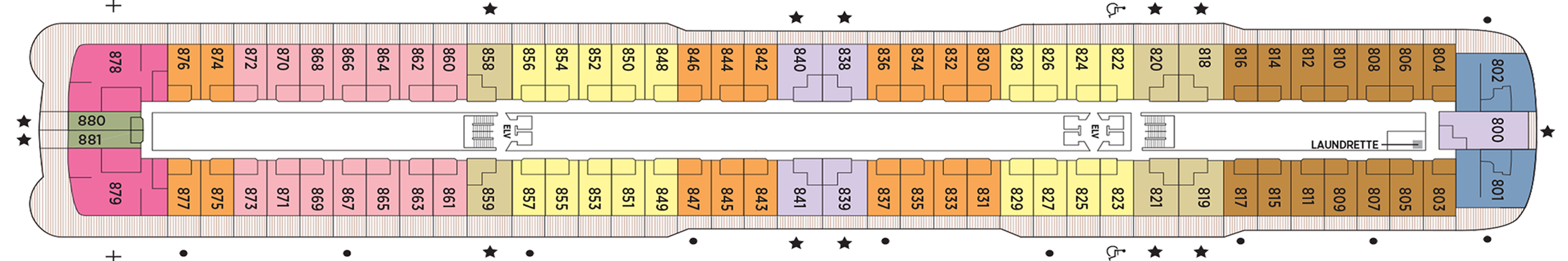
This category includes Accessibility Options in suites 822 and 823. For more information about accessible suites click here.
Amenities
- Valet Laundry Service
- 1-Night Pre-Cruise Hotel Package Including:- Ground Transfers- Breakfast- Porterage
- Unlimited WiFi includes up to four per suite
- 15 Minutes of Ship-to-Shore Phone Time
- L’Occitane® Jasmin & Bergamot Soaps, Shampoos and Lotions
- Welcome Bottle of Champagne with Fresh Fruit Arrangement
- In-Suite Mini-Bar Set-Up and Refill
- 24-Hour Room Service
- Priority Online Shore Excursions and Dining Reservations
- 10% Discount on Premium Wine and Liquor
- 5% savings on Pre- or Post-Cruise Hotel or Land Programs
- 5% savings on Regent Choice Shore Excursions
- Regent Plush Bathrobes and Slippers
- Binoculars, illy® Espresso Maker and Cashmere Blankets
- Vanity and Hair Dryer
- Interactive Flat-Screen Television With Extensive Media Library, Complimentary Movies-on-Demand
- Direct Dial Satellite Phone
- Shoe Shine Service
- Complimentary Tote Bag

With more than 400 square feet (121.9 meters) of space including a private balcony, this suite is an excellent choice if you want a little extra room. Even your sleeping accommodations are spacious, as the Elite Slumber™ bed is a European king-size and faces floor-to-ceiling windows that provide ocean views from your bed. A walk-in closet, dual sinks in the bathroom and wonderful bath amenities make it a pleasure to prepare for your day’s adventures.Layout
- Private Balcony
- Sitting Area
- Marble & Stone Detailed Bathroom
- European King-Size Elite Slumber® Bed
- Walk-In Closet with Safe
- Accommodates Up To 3 Guests
The suite pictured may differ from the suite booked, as layouts and designs vary by ship, deck, and suite location.
Amenities
- Unlimited WiFi Includes Two Logins, Two Devices, per Suite
- Valet Laundry Service
- Customizable In-Suite Mini Bar Replenished Daily with Your Preferences
- Welcome Bottle of Champagne & Fresh Fruit
- 24-hour In-Suite Dining
- Fresh Orchid Arrangement
- L'Occitane® Jasmin & Bergamot Bath Amenities
- Regent Plush Bathrobe & Slippers
- Interactive Flat-Screen Television & Direct-Dial Satellite Phone
- Vanity & Hair Dryer
- Shoe Shine Service
Thoughtfully designed to maximize interior space and embrace the magnificent scenery outdoors, this suite is a joyful retreat. From the sitting area, admire the ocean views through the floor-to-ceiling windows, or better yet, take a seat outside on your private balcony to watch the world go by. Elegant finishes such as luxurious bedding and beautiful marble detailing in the bath further enhance your comfort.
Layout
- Private Balcony
- Sitting Area
- Marble & Stone Detailed Bathroom Features a Glass-Enclosed Shower Instead of Bathtub
- European Queen-Size Elite Slumber® Bed
- Walk-In Closet with Safe
- Accommodates Up To 2 Guests
The suite pictured may differ from the suite booked, as layouts and designs vary by ship, deck, and suite location.
Amenities
- Unlimited WiFi Includes Two Logins, Two Devices, per Suite
- Valet Laundry Service
- Customizable In-Suite Mini Bar Replenished Daily with Your Preferences
- Welcome Bottle of Champagne & Fresh Fruit
- 24-hour In-Suite Dining
- Fresh Orchid Arrangement
- L'Occitane® Jasmin & Bergamot Bath Amenities
- Regent Plush Bathrobe & Slippers
- Interactive Flat-Screen Television & Direct-Dial Satellite Phone
- Vanity & Hair Dryer
- Shoe Shine Service
This suite is a wonderfully cozy retreat that includes a private balcony. In addition to a signature Elite Slumber™ bed, you’ll enjoy amenities such as lavish bath products, an interactive flat-screen TV and plush bathrobe and slippers. The intimate sitting area includes a table that is the perfect size for a welcome bottle of Champagne and an in-suite breakfast. For your convenience, 24-hour room service is a phone call away.
Layout
- Private Balcony
- Sitting Area
- Marble & Stone Detailed Bathroom Features a Glass-Enclosed Shower Instead of Bathtub
- European Queen-Size Elite Slumber® Bed
- Built-In Closet with Safe
- Accommodates Up To 2 Guests
The suite pictured may differ from the suite booked, as layouts and designs vary by ship, deck, and suite location.
Amenities
- Unlimited WiFi Includes Two Logins, Two Devices, per Suite
- Valet Laundry Service
- Customizable In-Suite Mini Bar Replenished Daily with Your Preferences
- Welcome Bottle of Champagne & Fresh Fruit
- 24-hour In-Suite Dining
- Fresh Orchid Arrangement
- L'Occitane® Jasmin & Bergamot Bath Amenities
- Regent Plush Bathrobe & Slippers
- Interactive Flat-Screen Television & Direct-Dial Satellite Phone
- Vanity & Hair Dryer
- Shoe Shine Service
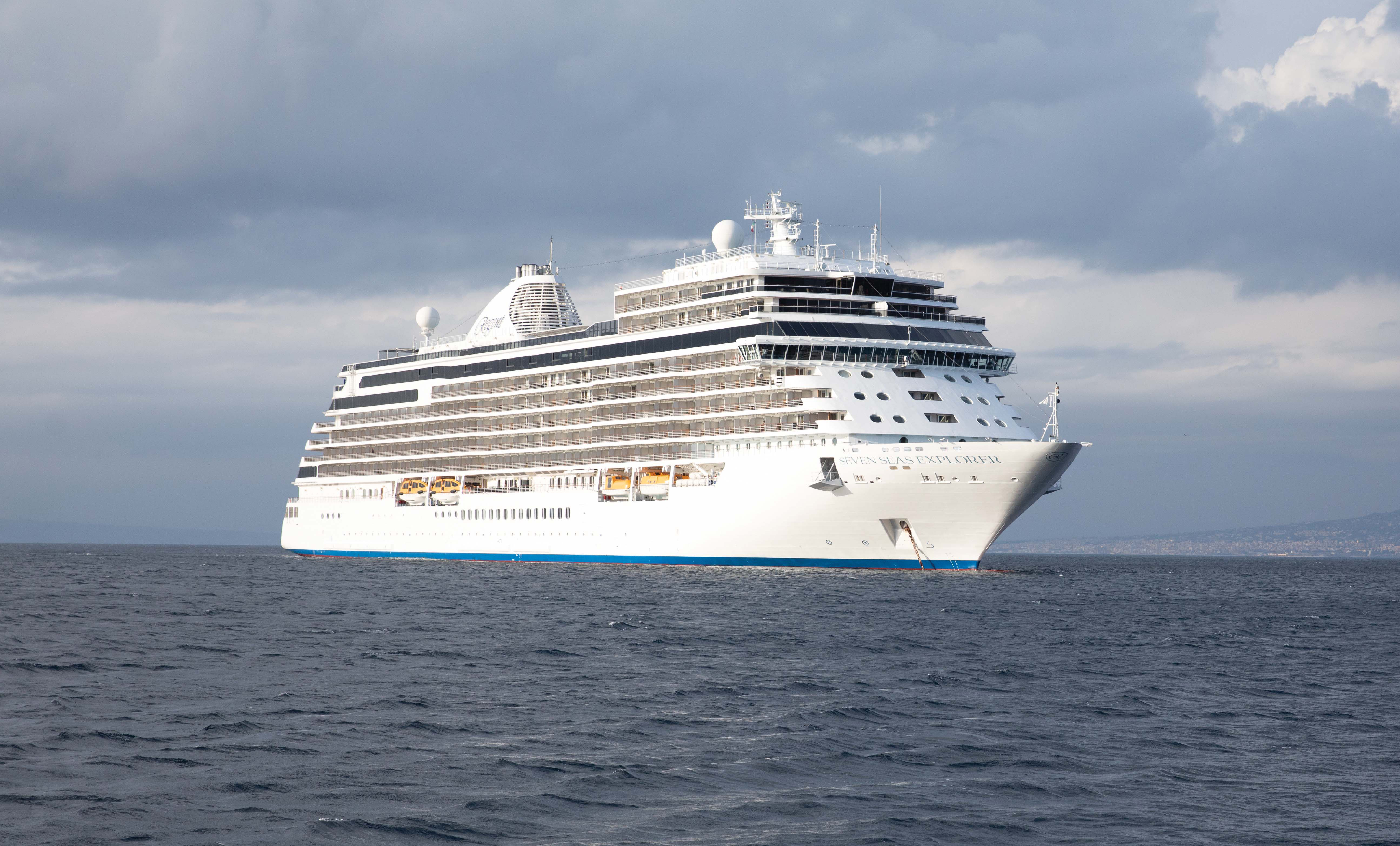
Seven Seas Explorer
Seven Seas Explorer® took luxury cruising to the next level, from the palatial Regent Suite to the hand-picked art accentuating her halls.
Ship Facts
| Launch Year | 2016 | ||||
| Refit Year | 2019 | ||||
| Language | en | ||||
| Gross Tonnage | 55254 | ||||
| Length | 224 | ||||
| Width | 31 | ||||
| Currency | USD | ||||
| Speed | 19 | ||||
| Capacity | 746 | ||||
| Crew Count | 548 | ||||
| Deck Count | 10 | ||||
| Cabin Count | 373 | ||||
| Large Cabin Count | 49 | ||||
| Wheelchair Cabin Count | 3 | ||||
| Electrical Plugs |
|
Deck 14
- Regent Suite
- Penthouse Suites
- Concierge Suites

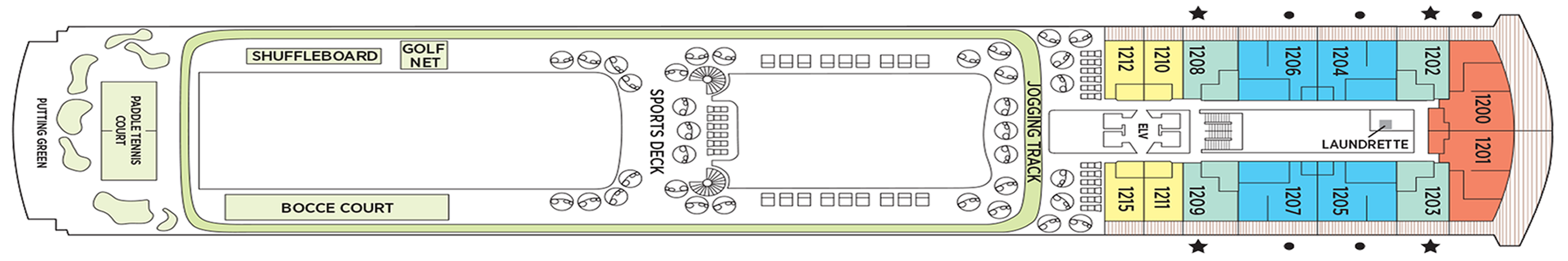
Deck 12
- Grand Suites
- Penthouse Suites
- Explorer Suites
- Concierge Suites
- Jogging Track
- Golf Nets
- Sports Deck
- Shuffle Board
- Bocce Court
- Paddle Tennis Court
- Putting Green
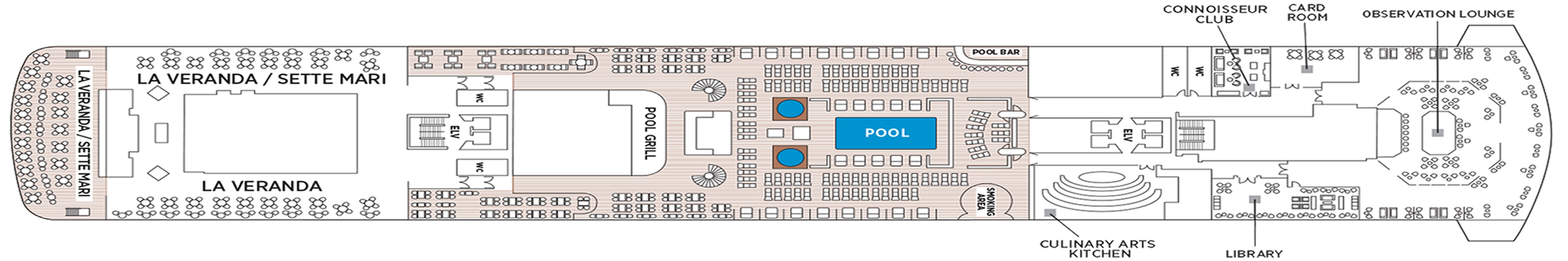
Deck 11
- Observation Lounge
- Card Room
- Connoisseur Club
- Library
- Culinary Arts Kitchen
- Pool Bar
- Smoking Area
- Pool Deck
- Pool Grill
- La Veranda/Sett Mari
- La Veranda
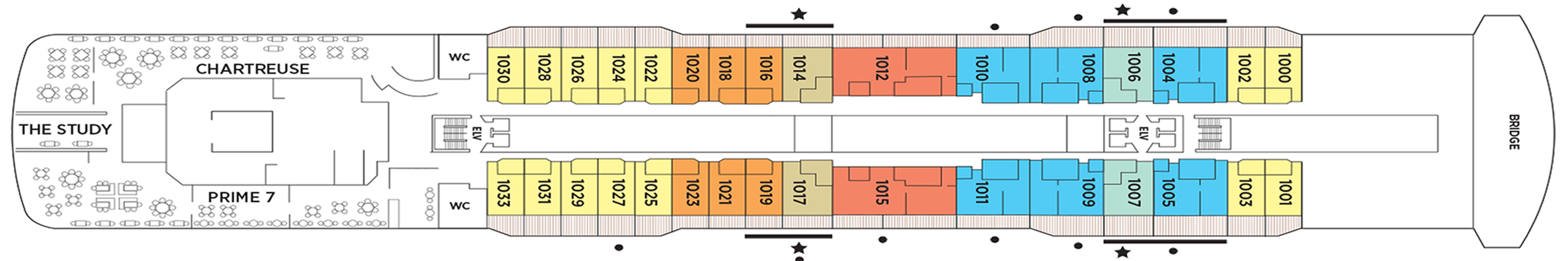
Deck 10
- Concierge Suites
- Explorer Suites
- Penthouse Suites
- Grand Suites (Forward)
- Serenity Suites
- Chartreuse
- Prime 7
- The Study
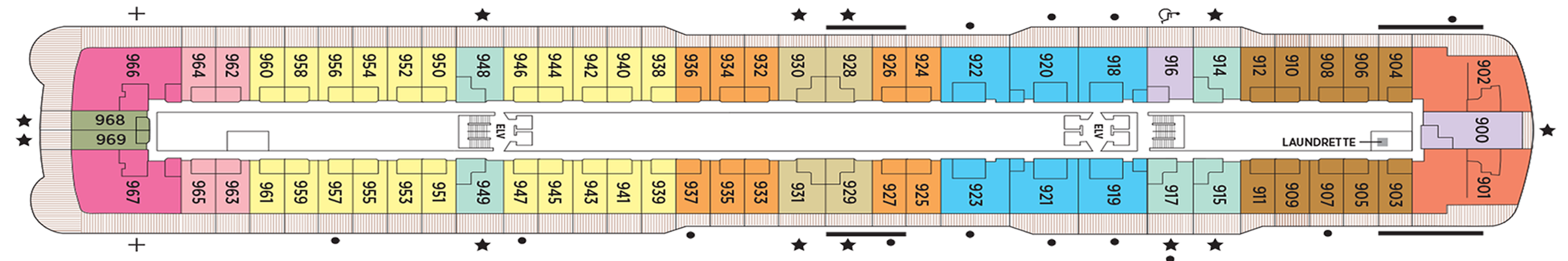
Deck 9
- Grand Suites
- Penthouse Suites
- Serenity Suites
- Explorer Suites
- Concierge Suites
- Deluxe Veranda Suites
Deck 8
- Penthouse Suites
- Seven Seas Suites
- Signature Suites
- Concierge Suites
- Serenity Suites
- Deluxe Veranda Suites
Deck 7
- Penthouse Suites
- Seven Seas Suites
- Serenity Suites
- Concierge Suites
- Veranda Suites
- Deluxe Veranda Suites
- Grand Suites (Aft)
Deck 6
- Fitness Centre
- Penthouse Suites
- Concierge Suites
- Deluxe Veranda Suites
- Veranda Suites
- Launderette
Deck 5
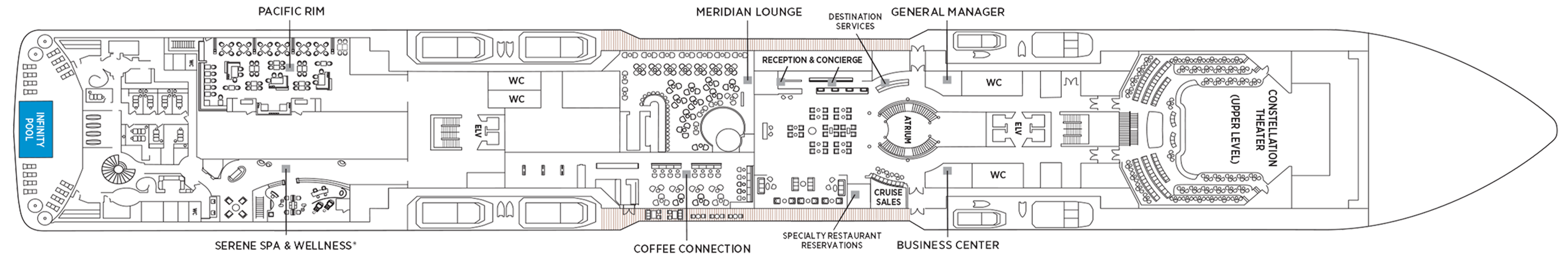
- Constellation Theatre
- General Manager
- Business Centre
- Destination Services
- Atrium
- Reception & Concierge
- Meridian Lounge
- Coffee Connection
- Pacific Rim
- Serene Spa & Wellness
- Infinity Pool
Deck 4
- Constellation Theatre
- Boutiques
- Explorer Lounge
- Atrium
- The Casino
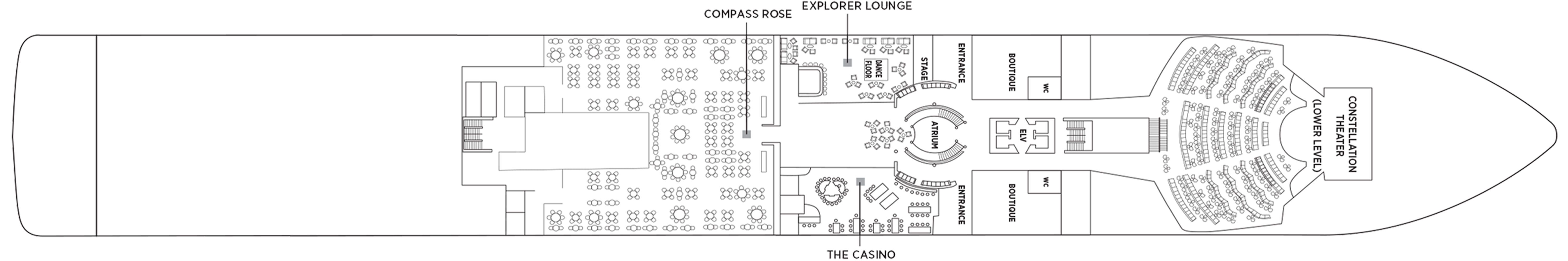
- Compass Rose
Regent Seven Seas Cruises® takes pride in creating dining experiences that are simply superb. From succulent lobster to the perfect burger and shake, you’ll find an array of refined flavors and refreshments from which to choose.
Pacific Rim
Walk past the Tibetan Prayer wheel at the Pacific Rim entrance and be prepared for an evening of culinary perfection with an array of Pan-Asian flavors and dishes. An elegantly exotic eatery.
Maximise your sense of the exotic as you pass a large Tibetan Prayer wheel on your way into Pacific Rim, our dining masterpiece that celebrates the culinary traditions of Asia. Taking a seat beneath huge lanterns and a hand-painted mural covering the entire back wall, you'll receive a signature cocktail and the promise of an extraordinary culinary journey. Be sure to check out the ocean views through Pacific Rim’s lotus-shaped windows.
Compass Rose
The wondrous colors outside Seven Seas Explorer® are no match for the vivid cobalt-blue glass installation on the ceiling of our elegant Compass Rose, a perfect setting for breakfast and dinner.
We are pleased to re-introduce the elegantly enhanced Compass Rose, the largest specialty restaurant across our fleet. Ensuring a tantalizing mix of new and familiar items on every visit, the new lunch and dinner menus offer a vast selection to meet your discerning tastes. Exclusively aboard Seven Seas Mariner®, Seven Seas Voyager®, and Seven Seas Navigator® for lunch, you may choose from a robust list of appetizers and main courses from our specialty restaurants. And across our fleet for dinner, you have the unique ability to design your very own entrée from preferred sides, sauces, pastas and main features of beef, poultry and fish. This is in addition to sinfully indulgent desserts made by talented bakers and pastry chefs. With daily changing menus, the refreshed Compass Rose offers more choices than ever before.
Pool Grill
When you desire a quick bite after sunbathing or swimming in the pool, our Pool Grill is the place for grilled-to-order burgers, seafood, sandwiches, even hand-dipped ice cream sprinkled with tasty toppings.
The Pool Grill is truly a come-as-you-are venue. Enjoy this casual dining experience whether you’re getting a bite after sunbathing or swimming in the pool. The Pool Grill is open-air, yet abundantly shaded for comfortable dining at lunch or dinner. Enjoy grilled-to-order burgers, grilled seafood, sandwiches, and fresh salads. Treat yourself to milkshakes and malts or an old-fashioned hand-dipped ice cream dessert with toppings.
La Veranda
Located on Deck 11 aft, guests take in stunning ocean views while enjoying elegant breakfast and lunch buffets in the chic indoor dining room or al fresco on the shaded, open-air deck.
Take in stunning ocean views while enjoying elegant breakfast and lunch buffets in the chic indoor dining room or al fresco on the shaded, open-air deck. Breakfasts include traditional favorites, as well as a made-to-order omelet station, a variety of fresh fruits and pastries, along with daily specials, like fluffy Belgian waffles with fresh blueberry compote. For lunch indulge in an array of choices from a bountiful salad bar, gourmet sandwiches, hot carving stations and delicious desserts.
Prime 7
From perfectly aged New York strip, porterhouse and succulent filet mignon to smoked salmon with a phenomenal tamarind-whiskey sauce, Prime 7 elevates classic American fare to lofty heights.
A true classic in every sense, Prime 7 sets a new standard in steakhouse fare with its contemporary interpretation of an American classic. Handsomely decorated with supple leather wing-back chairs, burnished woods and rich earth-toned fabrics, Prime 7 exudes a distinct, intimate elegance. This is sophistication redefined, a luxurious setting to enjoy classic steakhouse cuisine with a modern flair.
All the traditional starters are here, including Jumbo Lump Crab Cakes, Classic Steak Tartare, and Clam Chowder. Of course, beef is the undisputed star, and it is aged for a minimum of 40 days to ensure the ultimate tenderness and juiciness. New York Strip, Porterhouse Steak and succulent Filet Mignon only touch upon the selections. Mouthwatering alternatives include Applewood Smoked Salmon and Dover Sole.
Reservations Required
Sette Mari at La Veranda
Enjoy an extensive menu of authentic antipasti and Italian specialties served á la carte and paired with fine Italian wines. All dishes are prepared with the freshest gourmet ingredients and served by our attentive waiters.
Each evening, La Veranda transforms into Sette Mari at La Veranda, a casual, intimate dining experience. Choose from authentic Italian specialties inspired by family recipes that span generations, or opt for something with a modern twist like a spice-crusted tuna steak with braised endive, polenta and salmoriglio. Savour it all with a perfectly paired Tuscan wine. Sette Mari at La Veranda is open for dinner only.
Chartreuse
A restaurant with a modern French menu and attention to detail you’ll notice in its Parisian décor, expertly prepared dishes and wait staff. About the closest thing to a Parisian culinary gem on the high seas.
Chartreuse evokes memories of a chic Parisian fine dining restaurant discovered during an evening stroll. Wherever you are seated in this regal restaurant, you will be treated to a succulent dinner while enjoying incredible ocean views. The restaurant ambiance is complemented by a menu that features modern French dishes. Available on Seven Seas Grandeur™, Seven Seas Splendor®, Seven Seas Explorer®, Seven Seas Mariner® and Seven Seas Voyager® with reservations each evening for dinner, and open for lunch on Seven Seas Explorer on alternate port days. French bistro style food is offered.
Reservations Required
Coffee Connection
Grab a barista-made coffee, check the headlines of international newspapers or choose from a variety of handmade pastries in our cozy café which is open throughout the day.
Enjoy complimentary coffee drinks prepared by our baristas, as well as delicious pastries, gourmet sandwiches and homemade cookies. Whether perusing international newspapers or simply taking in an always spectacular view, our café is the perfect place to relax, converse and enjoy coffee and snacks throughout the day.
Room Service
Knowing that guests sometimes prefer to simply dine in the comfort of their suites, we offer room service around the clock. Select from an extensive room service menu and the wait staff will promptly serve your order in the comfort of your suite. During normal dining hours, guests may also order from the Compass Rose menu, which changes daily and features Continental, vegetarian, and kosher cuisines. Dinners will be graciously served course-by-course.
The Study
Guests of the most luxurious suite on the high seas — the Regent Suite on Seven Seas Explorer® — have exclusive access to The Study, a private, ornately decorated dining room that seats up to 12 guests.
In an atmosphere that's reminiscent of a personal library in an elegant, stately home, Regent Suite guests may gather in The Study to privately dine on meals from the adjacent Chartreuse and Prime 7 restaurants. Such an exclusive opportunity further establishes the Regent Suite on Seven Seas Explorer® as the pre-eminent luxury accommodation on the high seas.
Daytime Enrichment
You’ll find time spent on board the ship to be just as enriching as time ashore. Relax by the pool, compete in a friendly game of trivia or bocce ball, indulge in treats at afternoon tea and gain insight from an expert lecturer.
Evening Entertainment
Evenings on board are filled with music and fun. Enjoy a rousing cabaret show, test your luck at the Casino, step onto the stage for karaoke or simply find a quiet place on deck to revel in the symphony of stars.
Boutiques and More
Browse a well-curated selection of duty-free designer clothes, jewelry, perfume and more at the onboard boutiques. Then fuel up with an espresso from an onboard café or unwind at a wine tasting in one of the lounges.
Shows
From a dueling battle between genres and a story of romance to a thriller filled with intrigue, these are just a taste of the lavishly staged musical productions that await.
Explorer Lounge
The perfect spot to begin or end an evening, our Explorer Lounge inspires intimate conversations over perfectly mixed cocktails at an elegant, black marble bar while resident musicians play soothing live music.
With rich mahogany wood columns, heavy leather chairs and deep blue fabrics, the atmosphere here is conducive to intimate conversations and bonhomie. Relax to familiar tunes and special requests performed by our resident musicians from an intimate stage arched with a golden proscenium. A perfect spot to meet new friends for a pre- or post-dinner cocktail at the elegant, black marble bar.
Observation Lounge
With musicians performing throughout the day and night, captivating décor and floor-to-ceiling windows, you’ll be instantly drawn to this chic yet comfortable lounge as you unwind with a cocktail and jovial conversation.
Walk through a black and gold-lit tunnel and be instantly captivated. This chic yet comfortable lounge features an impressive bar, dazzling geometric ceiling, ample seating and floor-to-ceiling windows that create a magical atmosphere. Musicians perform throughout the day, creating an alluring vibe that sets just the right mood as you unwind with a pre-dinner cocktail or satisfying nightcap.
Constellation Theater
Even before the lights drop and a lavishly staged, high-energy show begins, you're greeted by a Gatsby-esque atmosphere of glamor and sophistication as you enter our Constellation Theatre.
A dazzling staircase mosaic creates a Gatsby-esque atmosphere as you enter our Constellation Theater, a space so grand it takes up two decks. Perfectly tiered for pleasing sightlines and furnished with plush seating, the main show lounge is an intimate venue without a bad seat in the house. Performances vary from full-scale musical revues to rousing singalongs, all backed by our incredible, five-piece Regent Signature Orchestra.
Connoisseur Club
Engage in spirited conversation with new friends in an elegant hideaway that calls to mind gentleman's clubs of old. An elegant throwback where cigars are savored, you’ll take to like a favorite cardigan.
Maybe it’s the deep blue walls that give the Connoisseur Club such a gentile, old-fashioned feel. Or maybe it’s the collection of impossible comfortable leather armchairs. Whatever it is, this is a relaxing spot for you and new friends to enjoy a fine cigar and sip cognac (both are available for purchase) in classic gentleman's club environs. Smoking is permitted in the club.
Atrium
Simply put, the Atrium is the very heart of Seven Seas Explorer®. Natural light cascades from above but it’s a magnificent chandelier shining like a glowing star that steals the show.
Often described as the crossroads of the ship, our Atrium is an inspiring testament to the grandeur of luxury ocean travel. Cascading stairwells make it a natural gathering place for guests, but convenience alone doesn’t begin to describe its magnetic appeal. On Seven Seas Explorer® a spectacular chandelier hovers like a glowing star, enhancing the natural light shining down from far above.
The Casino
Enjoy the elegance and excitement of a Monte Carlo-style casino. Stride through the Casino's glass doors to an elegant setting abuzz with Blackjack, roulette, poker, as well as slot machines.
Get a taste of Monte Carlo excitement at our Casino directly across from the equally inspiring Explorer Lounge. Walk through glass doors into an elegant setting bustling with games of chance that include Blackjack, roulette, poker, as well as slot machines. The Casino is open every day at sea when not restricted by territorial border limits.
Meridian Lounge
A popular spot for informal gatherings over impromptu cocktails, you may find yourself here after a thrilling theater experience. Meridian Lounge is a spacious, friendly space with an expansive bar and live music at night.
Situated along a lively hallway, Meridian Lounge is a natural place to gather with others for an afternoon or early evening cocktail. Elegantly appointed and comfortably furnished, it boasts an expansive bar and relaxed armchairs that beckon conversation. A popular spot to catch your breath after a dazzling Constellation Theatre show, this lively spot invites you to extend your evening with virtuoso performances by resident musicians.
Card Room
Clubby and comfortable, our Card Room is a charming spot for you and new friends to gather for friendly competition in elegant surroundings.
An inviting and tranquil oasis dedicated to the pure pleasure of playing games. Our beautifully decorated Card Room sits across from Observation Lounge, and it’s not unusual for guests to go from one fun space to the other. Gather your favourite teammates in the Card Room for a lively afternoon or evening of board games, a social game of Bridge or to participate in an ACBL Tournament on select voyages.
Library
Choose from a large selection of reading material in our Library, a relaxing retreat dedicated to calming the senses as well as stimulating the brain.
Well-stocked and exceedingly comfortable, you'll immediately feel at ease within the Library’s calm setting. Browse a vast collection of volumes, from destination-specific guide books to best-selling mysteries to classics of literature, on a variety of comfortable chairs. Conveniently located across from the Card Room, our library is a welcoming, low-key treasure you just may find hard to leave.
Boutique
Perhaps it's a dress to wear for dinner or a piece of jewellery that calls your name. Our boutique items are carefully selected, providing you with quality handbags, fragrances and clothes to give as gifts... or give yourself.
Whether looking for something special to wear for dinner or a memento for friends and family back home, you’re bound to be tempted by the designer garments and fashionable accessories in our shops. Relax as you browse a wide range of items – upscale handbags to exclusive fragrances to fine jewellery and more – in an intimate and unhurried setting.
Pool Bar
Very few things equate to a pure vacation activity more than sitting at our Pool Bar. Make new friends while sipping a cocktail or frozen drink in the most laid-back atmosphere imaginable.
When you envision an activity you’re only likely to do while on vacation, sipping a frozen drink at a pool bar onboard a glorious cruise ship is probably near the top of the list. You can tick that box at our Pool Bar, where you and new friends can enjoy leisurely conversation over cocktails and frozen drinks in a delightfully relaxed atmosphere.
Business Centre
For those who've chosen to leave their laptops at home, desktop computers are available at our staffed Business Centre. Of course, you may access WiFi without charge throughout the entirety of the ship.
If you prefer to travel without a laptop, our staffed Business Center offers desktop computers that allow you to access your emails and browse the Internet. Printer access is available for a nominal fee. Seven Seas Explorer® provides WiFi access throughout the ship, allowing you to connect to the Internet with whatever device you've brought on board.
Reception & Concierge/General Manager
Turn to the Reception Desk for answers to questions about your Seven Seas Explorer® experience. Our knowledgeable staff is available day and night. You may also contact the ship's Concierge here.
Our Reception Desk is the place to turn to have your every wish, whim and want fulfilled any time of day or night. Our knowledgeable, personable staff will welcome your questions and work to ensure your Seven Seas Explorer® experience is everything you want it to be. The ship's Concierge may also be contacted at the Reception Desk.
While cruise-related issues are first submitted to Reception/Concierge, you can be assured that a General Manager is on hand to resolve issues to your satisfaction.
Accountability is a critical aspect of providing you with an unrivalled experience on Regent Seven Seas Cruises®. As a guest you'll always know where to find our General Manager, whose sole responsibility is making sure things are running as they should — and that includes providing you with superior customer service.
Destination Services
A great resource if you’re keen on making the most of your time in port cities. Visit Destination Services to book a FREE Unlimited Shore Excursion or unique, small-group Regent Choice Shore Excursion.
Whether you’re interested in a tour from our FREE Unlimited Shore Excursion menu or a customisable Regent Choice Shore Excursion, our staff at Destination Services is ready to help you make the most of your time in port cities. Head here for assistance with tailor-made pre-and post-cruise programs, from a simple stay in a luxurious hotel to a 3-night extension that includes private tours of coveted destinations.