Journey To The Amazon
Journey To The Amazon
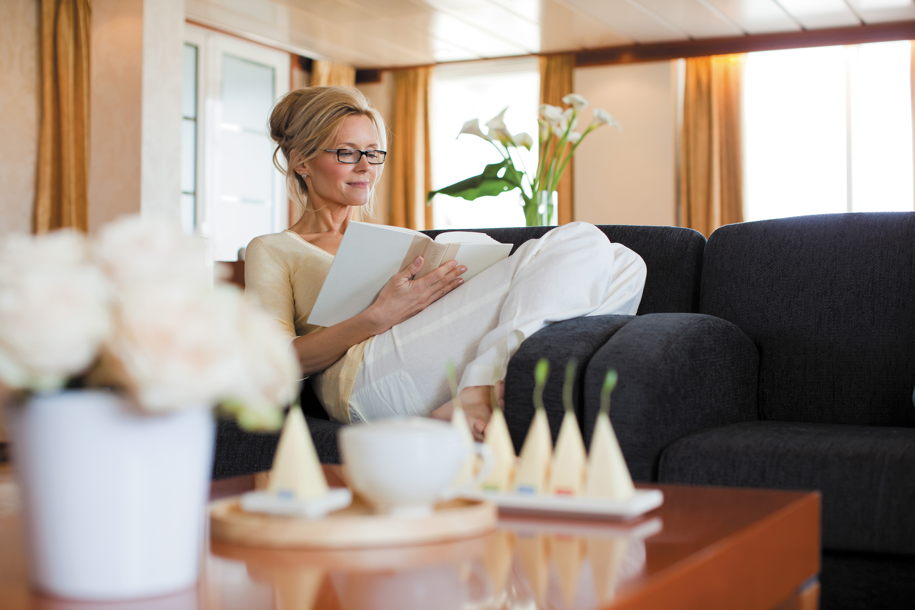
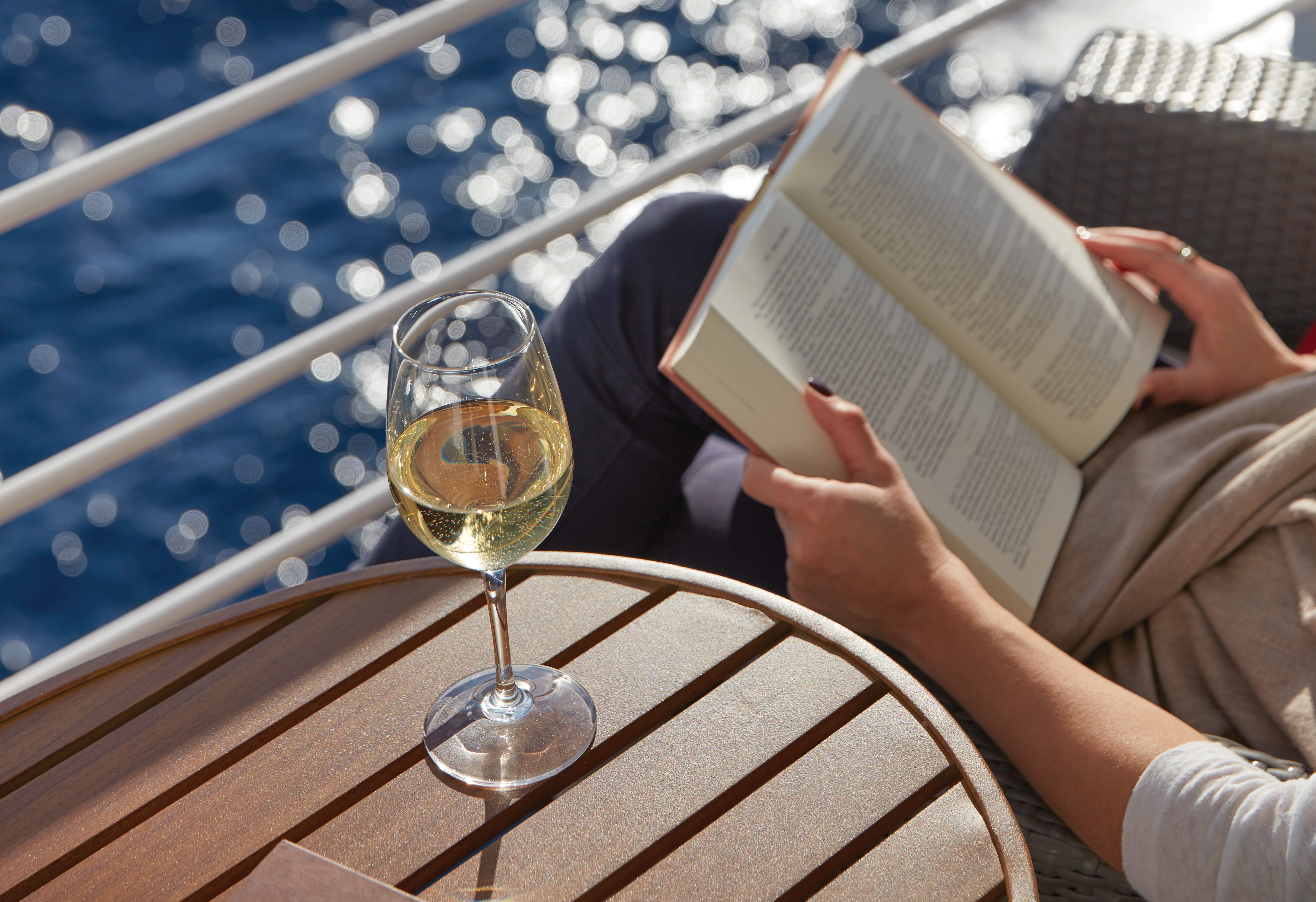
Cruise overview
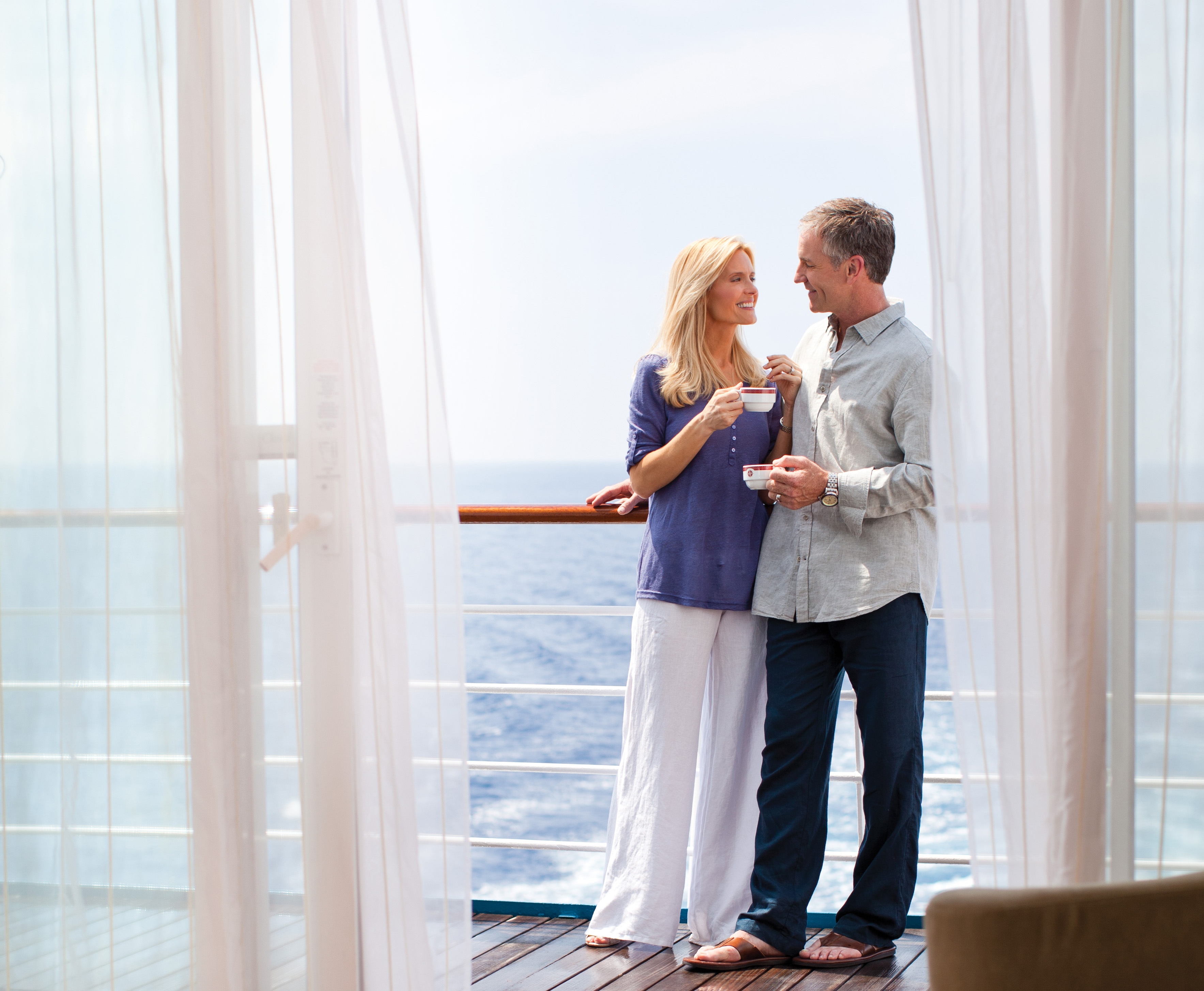
WHY BOOK WITH US?
- ✔ The Deluxe Cruises’ team has extensive experience in ultra-luxury cruising.
- ✔ Call now to speak to our helpful and experienced Cruise Concierge team.
- ✔ Enjoy our Unique Deluxe Cruises Bonus for substantial savings.
- ✔ Our team will tailor your holiday to your exacting requirements.
- ✔ As agents, we work under the protection of each cruise lines ABTA / ATOL licences
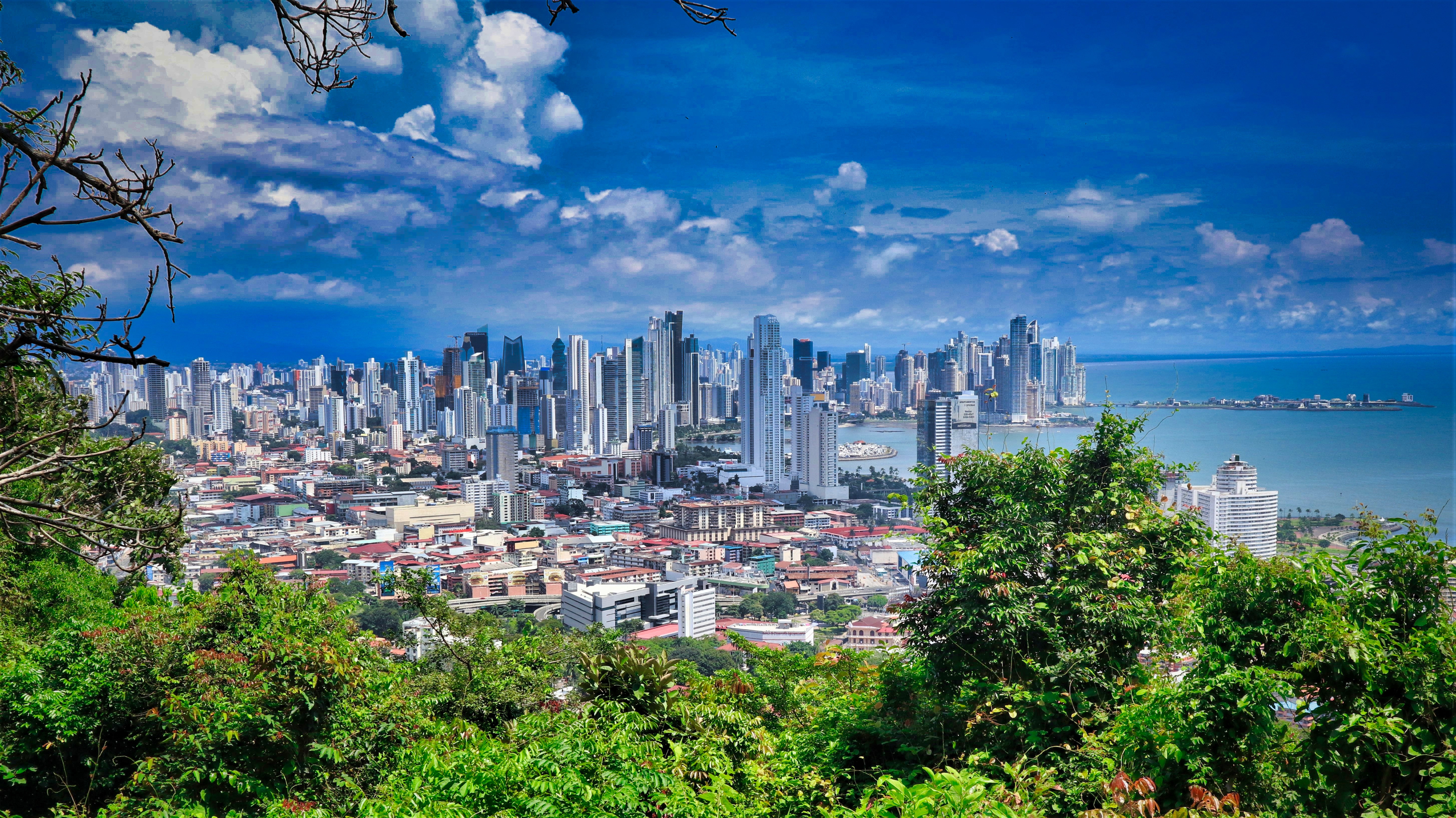
About Panama City
Expect incredible morning views as you arrive into the port for Panama City. Tinged with a silver pre-dawn light, the city will metamorphosise into a golden glow as the sun rises above it. And from then on expect one stunning view after another. Very interesting in its own right, Fuerte Amador is obviously overshadowed by its proximity to Panama City. So should the Miraflores museum of the Canal, which offers a comprehensive and immersive tour of the Canal including a 3-D experience, four exhibition halls, an observation deck, and a surprisingly good restaurant not interest you then there is always the option of lovely Casco Viejo – literally the old quartier of Panama. The grand old colonial houses, cobbled streets, independent boutiques and buzzing street scene make this a must stop on your itinerary. And if you like seafood, you will not want miss the many restaurants and market stalls serving different variations of so-fresh-it’s-still-practically-swimming ceviche. Best eaten like the Panamanians do, with salty crackers and a cold beer on the beach. And if money is no object, a cup of geisha coffee – supposedly the world’s best and definitely the world’s most expensive at $7 a shot is definitely a pick me up! Cool cosmopolitan capital aside, Panama has a skyscraper filled skyline that is worthy of some of its North American counterparts. But if urban utopia is not your scene then fear not, the sandy beaches and lush rainforests are never more than a short cab ride away.
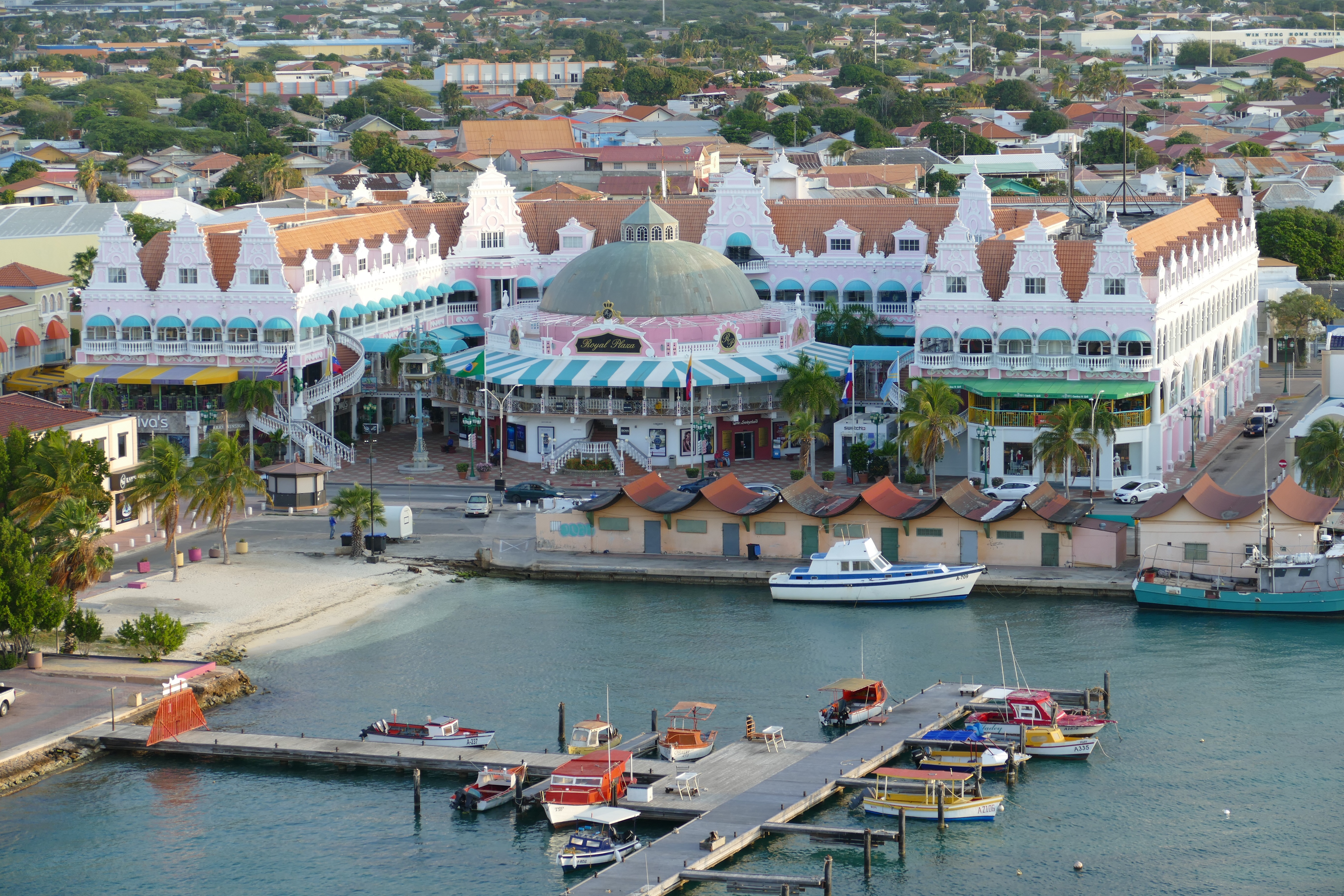
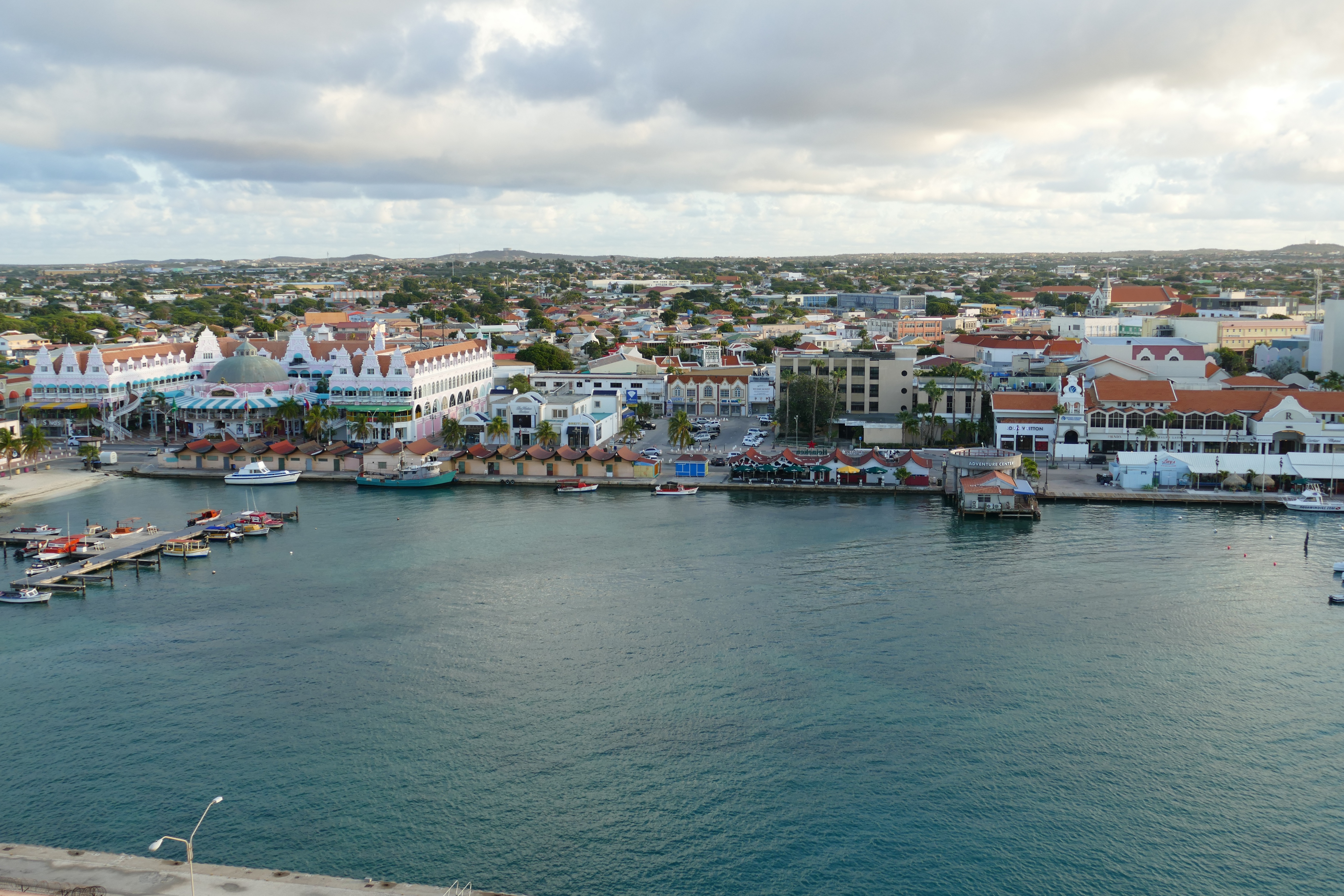
About Oranjestad
Aruba's capital is easily explored on foot. Its palm-lined central thoroughfare runs between old and new pastel-painted buildings of typical Dutch design (Spanish influence is also evident in some of the architecture). There are a lot of malls with boutiques and shops—the Renaissance mall carries high-end luxury items and designer fashions. A massive renovation in downtown has given Main Street (a.k.a. Caya G. F. Betico Croes) behind the Renaissance Resort a whole new lease on life: boutique malls, shops, and restaurants have opened next to well-loved family-run businesses. The pedestrian-only walkway and resting areas have unclogged the street, and the new eco-trolley is free and a great way to get around. At this writing, Linear Park was well and will showcase local merchants and artists. There will be activities along a boardwalk that will eventually run all the way to the end of Palm Beach, making it the longest of its kind in the Caribbean.
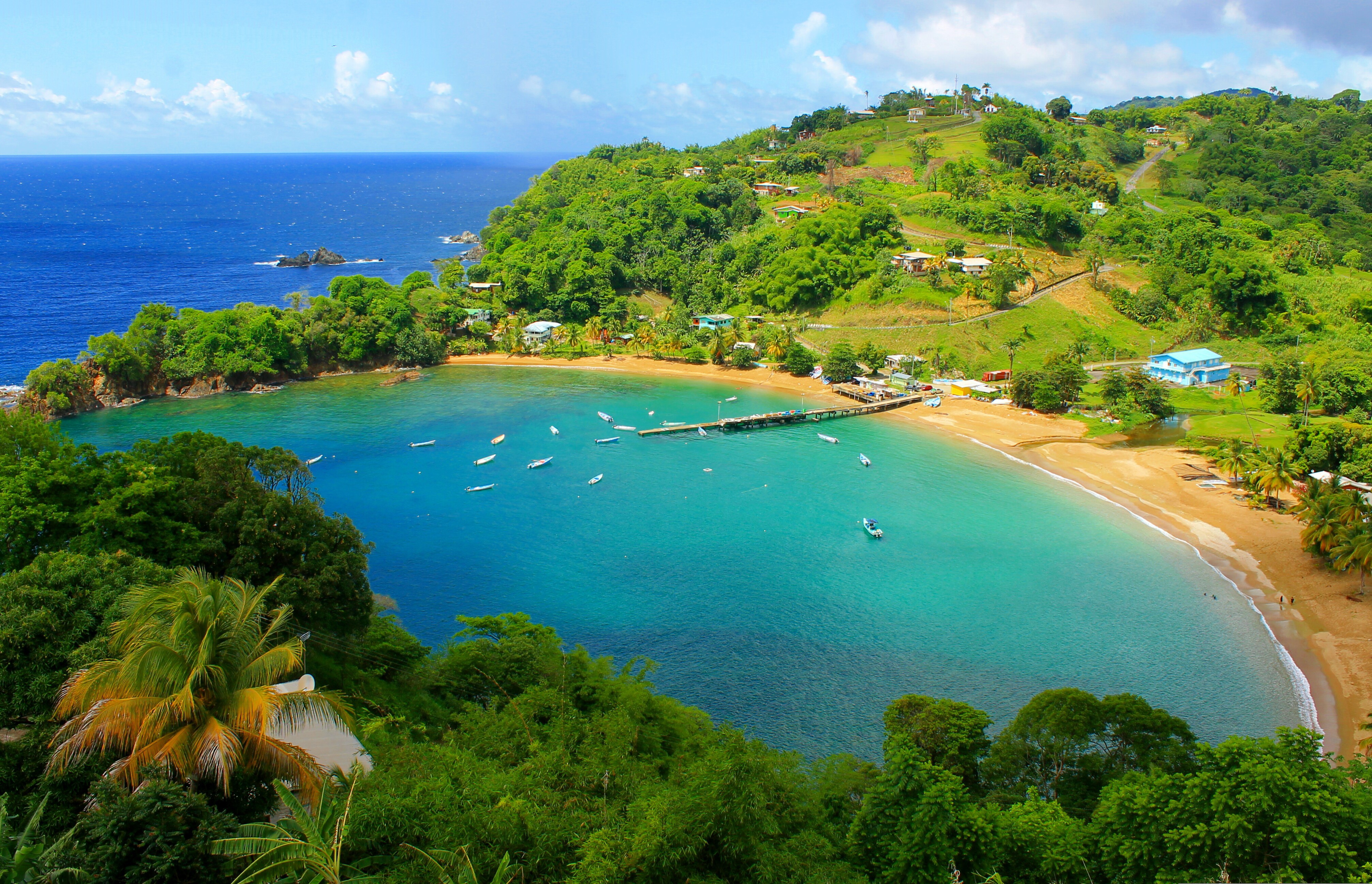
About Port-of-Spain
Port of Spain is a seaport on the north-west coast of the island of Trinidad. The capital and commercial centre of Trinidad and Tobago, Port of Spain has architecture from around the world from Hindu temples to gingerbread Rococo. Trinidad, home of the carnival and the steel band, is an astonishing melting-pot of people and cultures - including African, Oriental, Indian, European and New World. It is also home to an interesting array of South American flora, as well as more than 400 species of birds, some of which can be seen if you visit the Asa Wright Nature Reserve. A Native American village known as Conquerabia occupied the site when the Spanish settled in the area in 1595 and renamed the community 'Puerto de España'. After the British took control of the island in 1797, the settlement's name was anglicised to Port of Spain. The city served as the capital of the Federation of the West Indies from 1958 to 1962, before the grouping was dissolved.
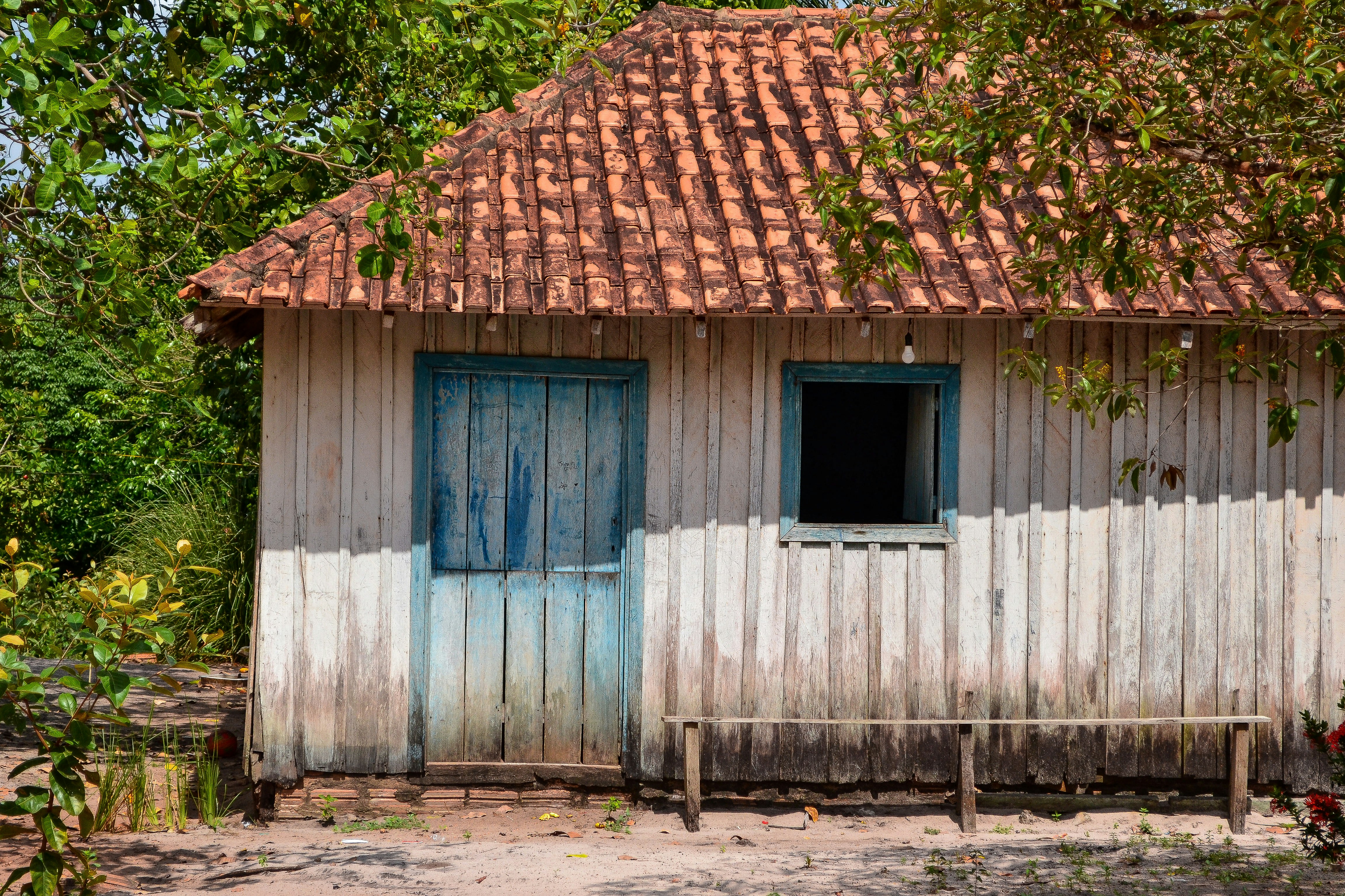
About Manaus
A hidden metropolis inside of the Amazon Rainforest in Brazil, this city is both modern and exciting, yet untouched by the world beyond the jungle. Visit its historical Rubber Museums or stop by the Park of Mindu and catch glimpse of the endangered Pied Tamarin.
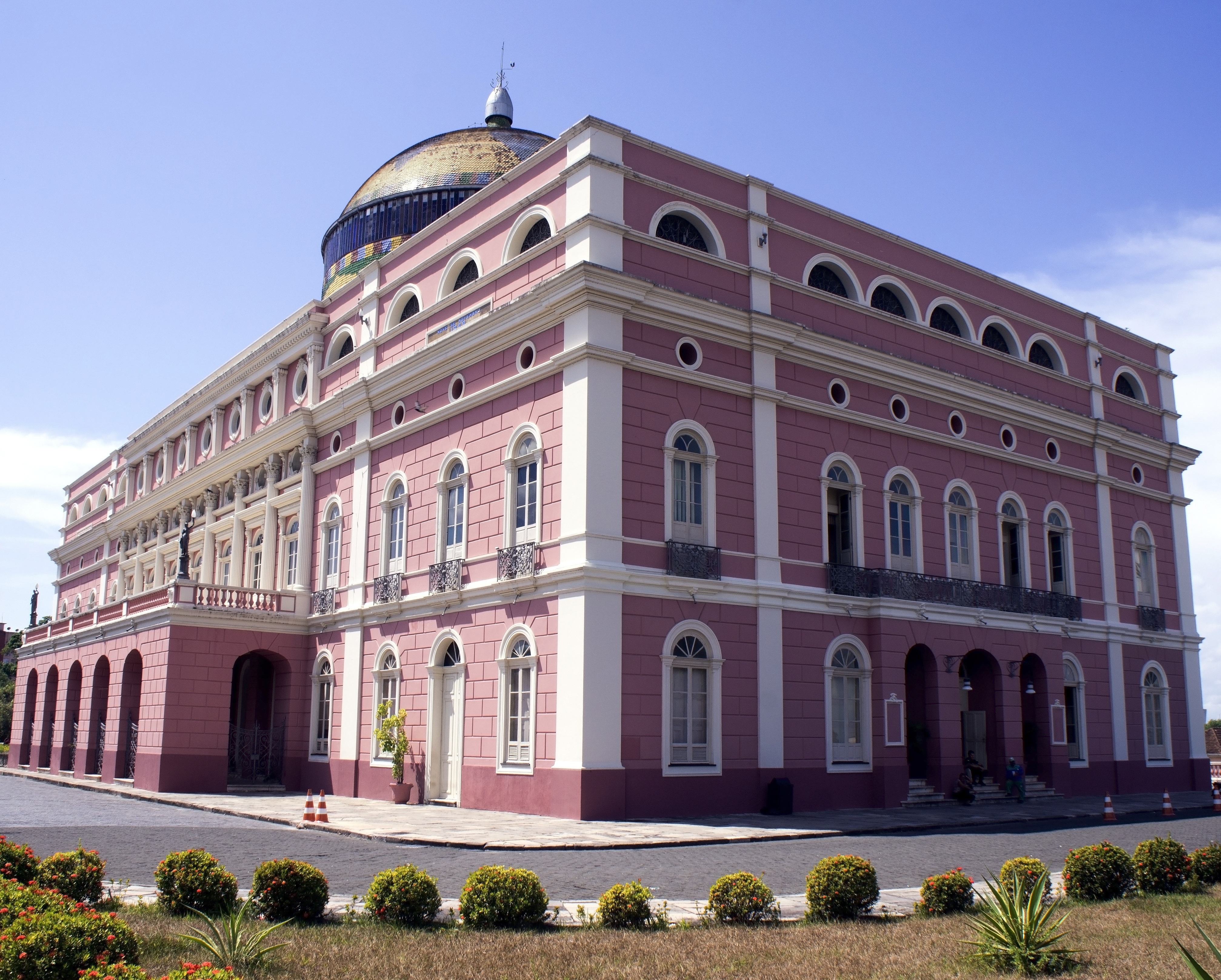
About Manaus
A hidden metropolis inside of the Amazon Rainforest in Brazil, this city is both modern and exciting, yet untouched by the world beyond the jungle. Visit its historical Rubber Museums or stop by the Park of Mindu and catch glimpse of the endangered Pied Tamarin.
About Boca de Valeria
About Alter do Chão

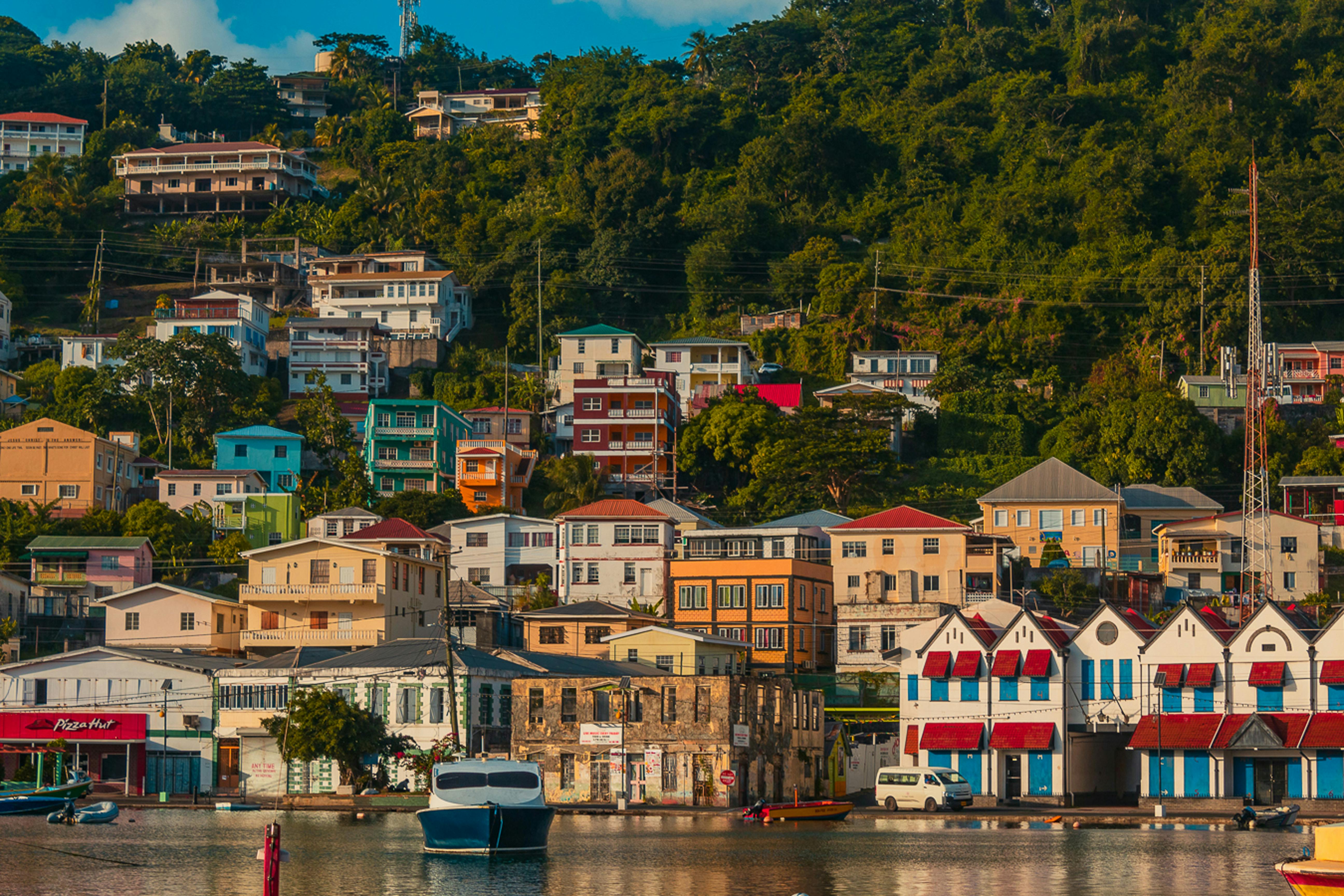
About Saint George's
Nutmeg, cinnamon, cloves, cocoa those heady aromas fill the air in Grenada (pronounced gruh-nay-da). Only 21 miles (33½ km) long and 12 miles (19½ km) wide, the Isle of Spice is a tropical gem of lush rain forests, white-sand beaches, secluded coves, exotic flowers, and enough locally grown spices to fill anyone's kitchen cabinet. St. George's is one of the most picturesque capital cities in the Caribbean, St. George's Harbour is one of the most picturesque harbors, and Grenada's Grand Anse Beach is one of the region's finest beaches. The island has friendly, hospitable people and enough good shopping, restaurants, historic sites, and natural wonders to make it a popular port of call. About one-third of Grenada's visitors arrive by cruise ship, and that number continues to grow each year. Grenada's capital is a bustling West Indian city, much of which remains unchanged from colonial days. Narrow streets lined with shops wind up, down, and across steep hills. Brick warehouses cling to the waterfront, and pastel-painted homes rise from the waterfront and disappear into steep green hills. The horseshoe-shaped St. George's Harbour, a submerged volcanic crater, is arguably the prettiest harbor in the Caribbean. Schooners, ferries, and tour boats tie up along the seawall or at the small dinghy dock. The Carenage (pronounced car-a-nahzh), which surrounds the harbor, is the capital's center. Warehouses, shops, and restaurants line the waterfront. The Christ of the Deep statue that sits on the pedestrian plaza at the center of The Carenage was presented to Grenada by Costa Cruise Line in remembrance of its ship, Bianca C, which burned and sank in the harbor in 1961 and is now a favorite dive site. An engineering feat for its time, the 340-foot-long Sendall Tunnel was built in 1895 and named for Walter Sendall, an early governor. The narrow tunnel, used by both pedestrians and vehicles, separates the harbor side of St. George's from the Esplanade on the bay side of town, where you can find the markets (produce, meat, and fish), the Cruise Ship Terminal, the Esplanade Mall, and the public bus station.
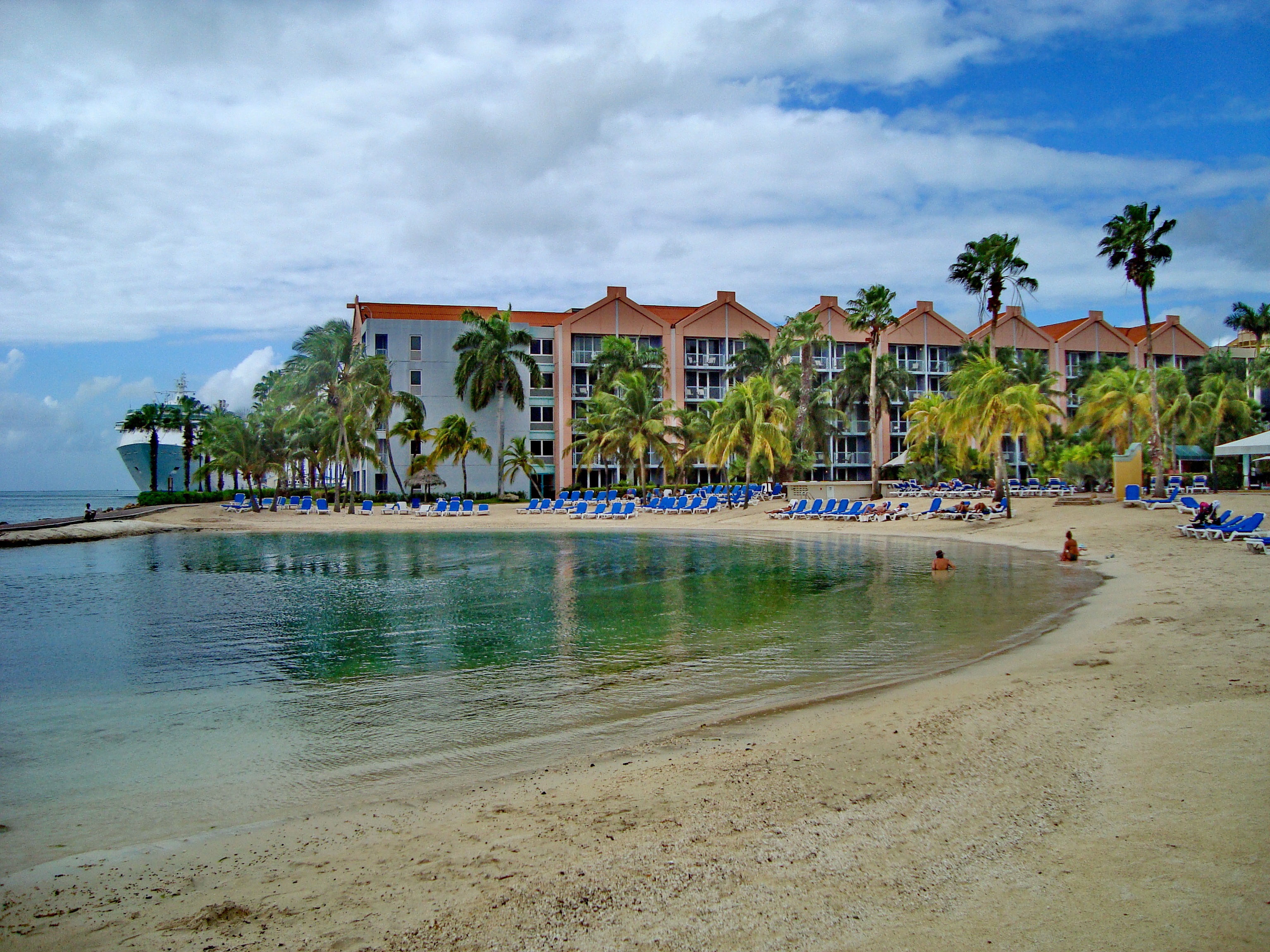
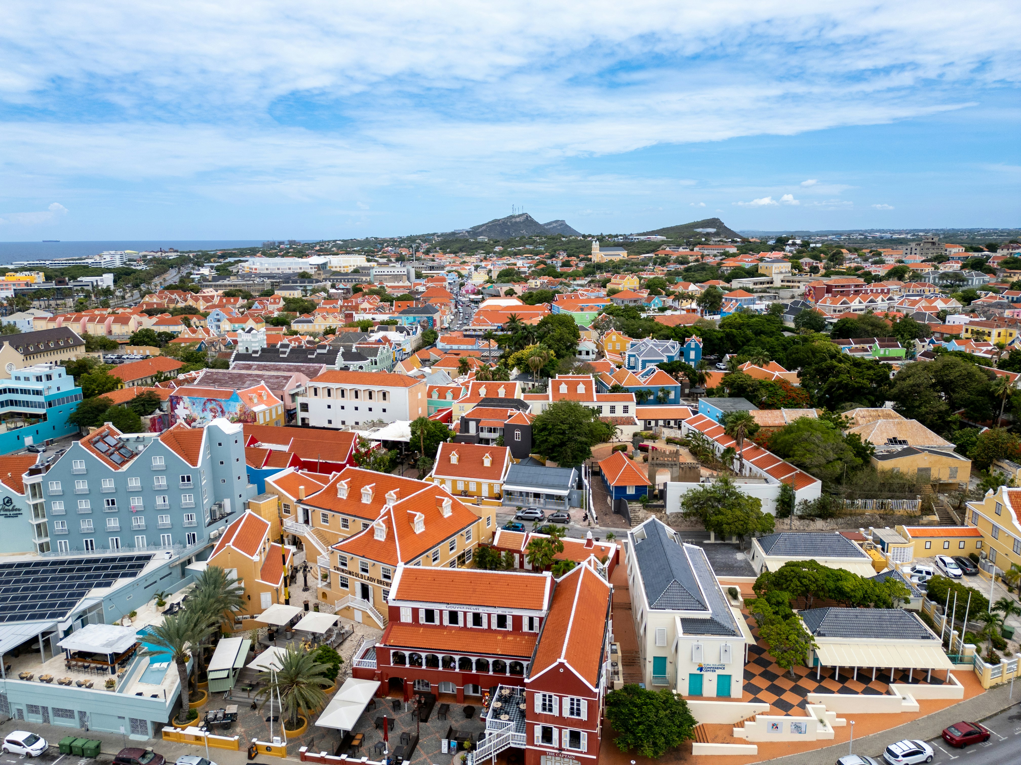
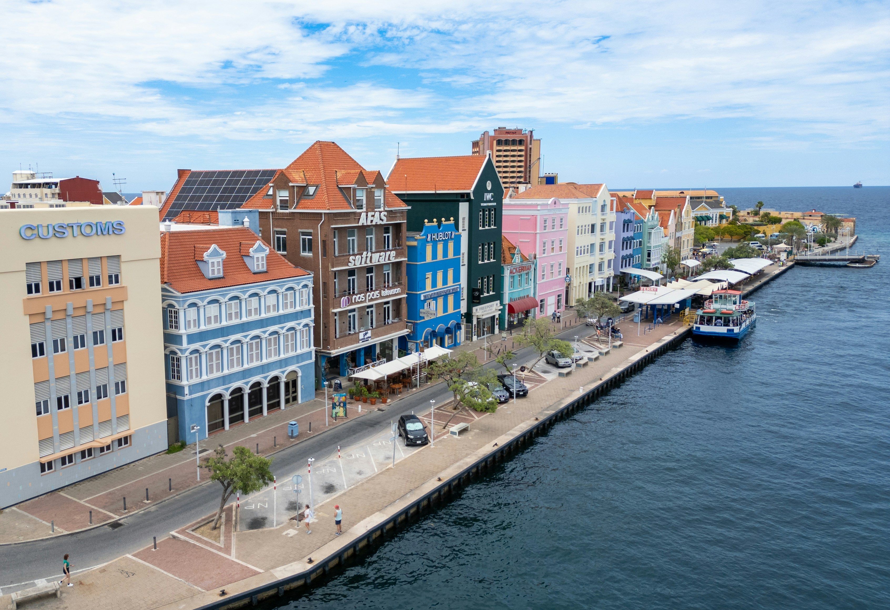
About Willemstad
Dutch settlers came here in the 1630s, about the same time they sailed through the Verazzano Narrows to Manhattan, bringing with them original red-tile roofs, first used on the trade ships as ballast and later incorporated into the architecture of Willemstad. Much of the original colonial structures remain, but this historic city is constantly reinventing itself and the government monument foundation is always busy restoring buildings in one urban neighborhood or another. The salty air causes what is called "wall cancer" which causes the ancient abodes to continually crumble over time. The city is cut in two by Santa Anna Bay. On one side is Punda (the point)—crammed with shops, restaurants, monuments, and markets and a new museum retracing its colorful history. And on the other side is Otrobanda (literally meaning the "other side"), with lots of narrow, winding streets and alleyways (called "steekjes" in Dutch), full of private homes notable for their picturesque gables and Dutch-influenced designs. In recent years the ongoing regeneration of Otrobanda has been apparent, marked by a surge in development of new hotels, restaurants, and shops; the rebirth, concentrated near the waterfront, was spearheaded by the creation of the elaborate Kura Hulanda complex.There are three ways to cross the bay: by car over the Juliana Bridge; by foot over the Queen Emma pontoon bridge (locally called "The Swinging Old Lady"); or by free ferry, which runs when the pontoon bridge is swung open for passing ships. All the major hotels outside town offer free shuttle service to town once or twice daily. Shuttles coming from the Otrobanda side leave you at Riffort. From here it's a short walk north to the foot of the pontoon bridge. Shuttles coming from the Punda side leave you near the main entrance to Ft. Amsterdam.
About Panama City
Expect incredible morning views as you arrive into the port for Panama City. Tinged with a silver pre-dawn light, the city will metamorphosise into a golden glow as the sun rises above it. And from then on expect one stunning view after another. Very interesting in its own right, Fuerte Amador is obviously overshadowed by its proximity to Panama City. So should the Miraflores museum of the Canal, which offers a comprehensive and immersive tour of the Canal including a 3-D experience, four exhibition halls, an observation deck, and a surprisingly good restaurant not interest you then there is always the option of lovely Casco Viejo – literally the old quartier of Panama. The grand old colonial houses, cobbled streets, independent boutiques and buzzing street scene make this a must stop on your itinerary. And if you like seafood, you will not want miss the many restaurants and market stalls serving different variations of so-fresh-it’s-still-practically-swimming ceviche. Best eaten like the Panamanians do, with salty crackers and a cold beer on the beach. And if money is no object, a cup of geisha coffee – supposedly the world’s best and definitely the world’s most expensive at $7 a shot is definitely a pick me up! Cool cosmopolitan capital aside, Panama has a skyscraper filled skyline that is worthy of some of its North American counterparts. But if urban utopia is not your scene then fear not, the sandy beaches and lush rainforests are never more than a short cab ride away.
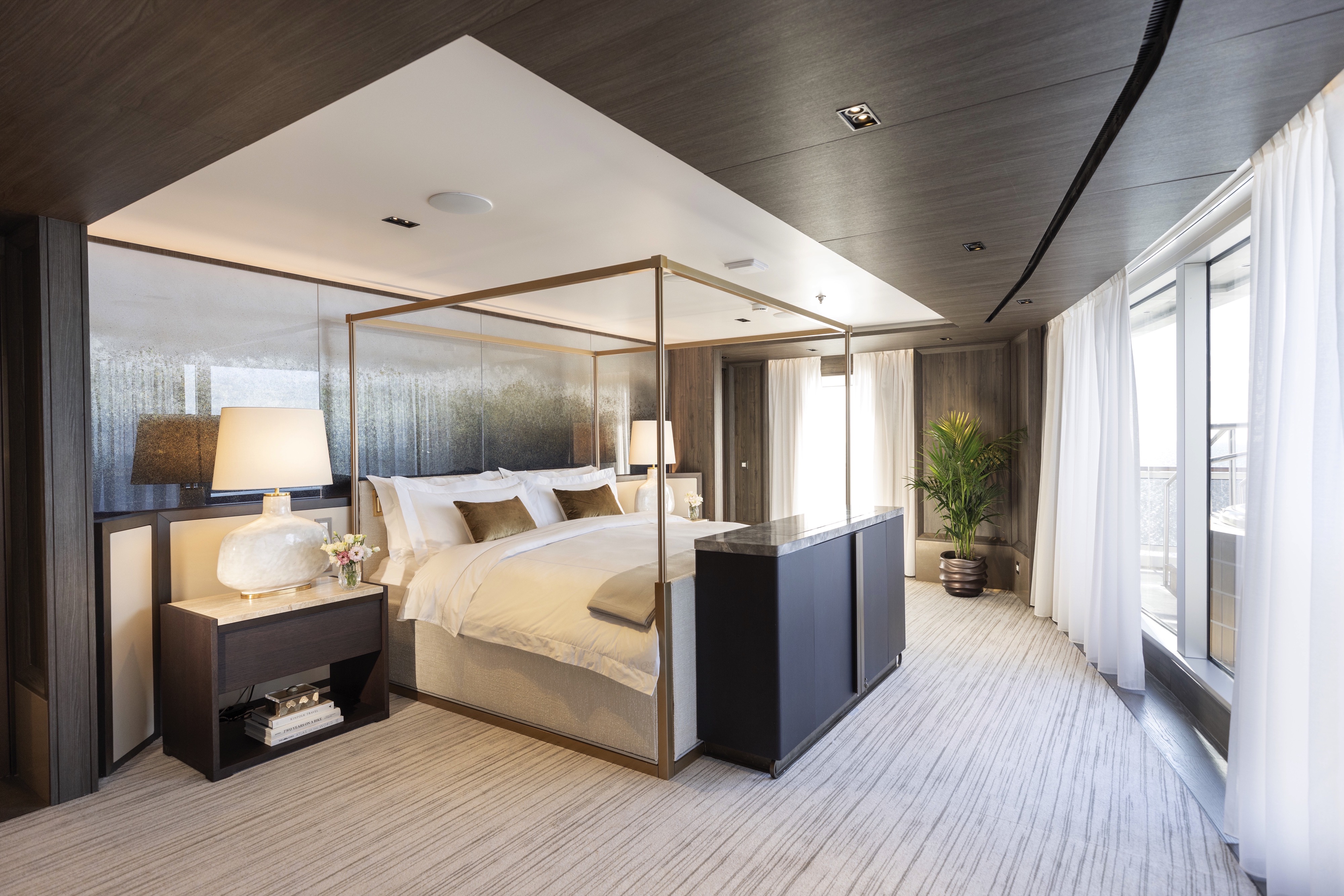
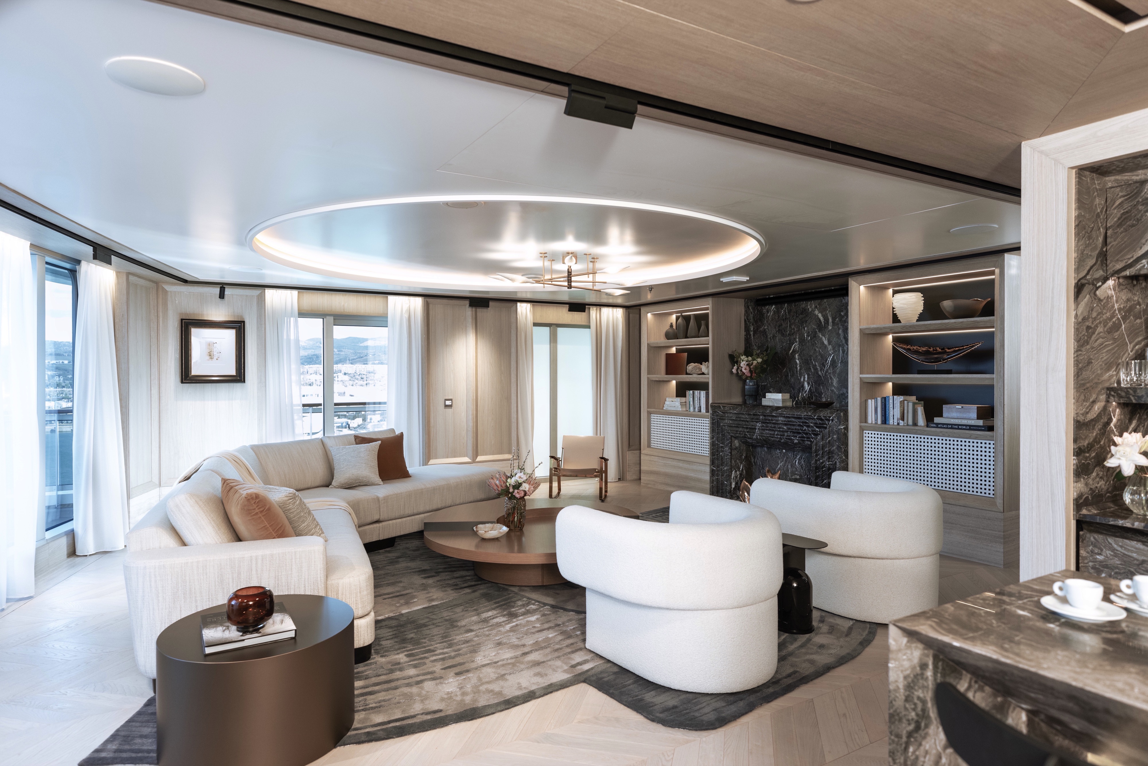
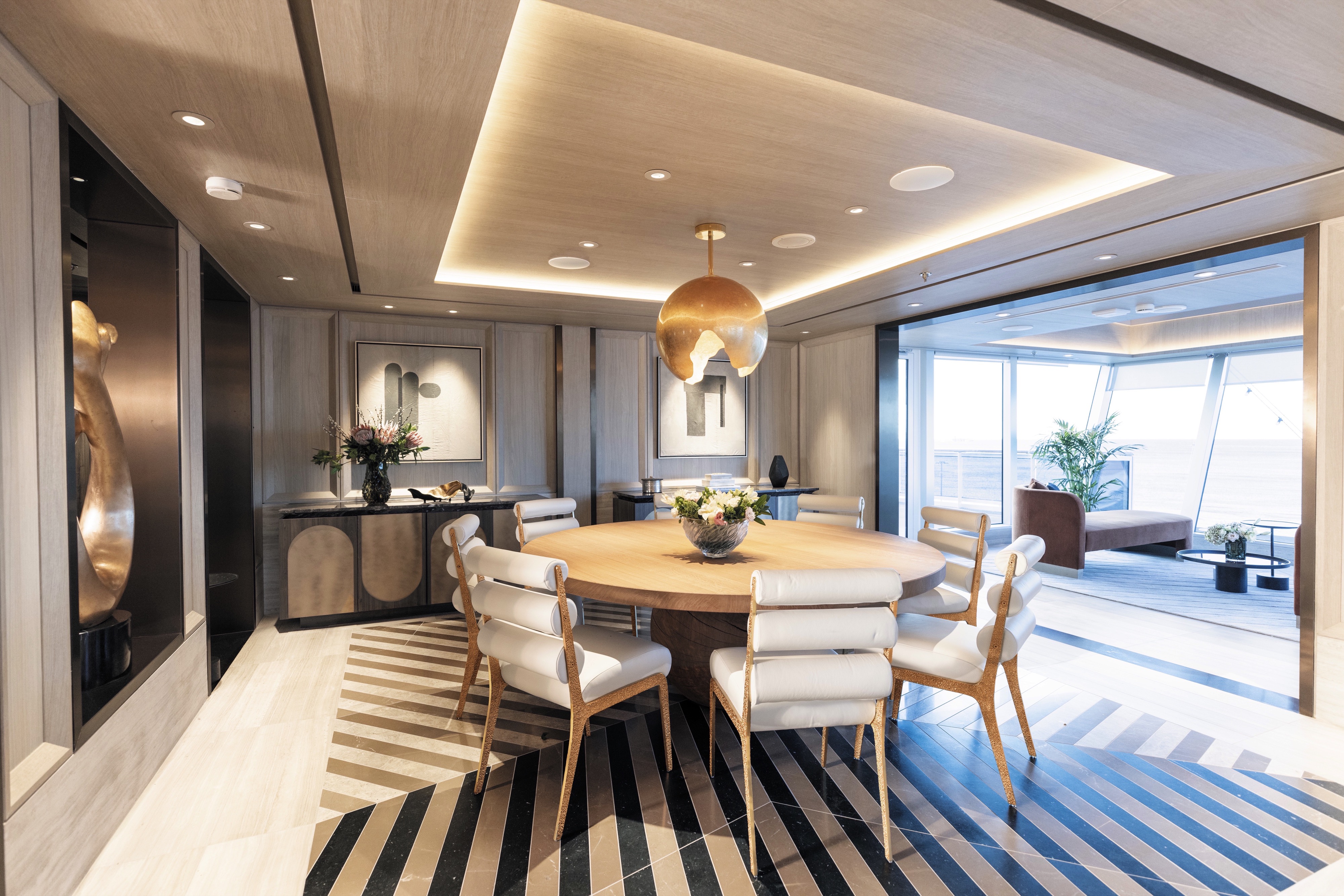
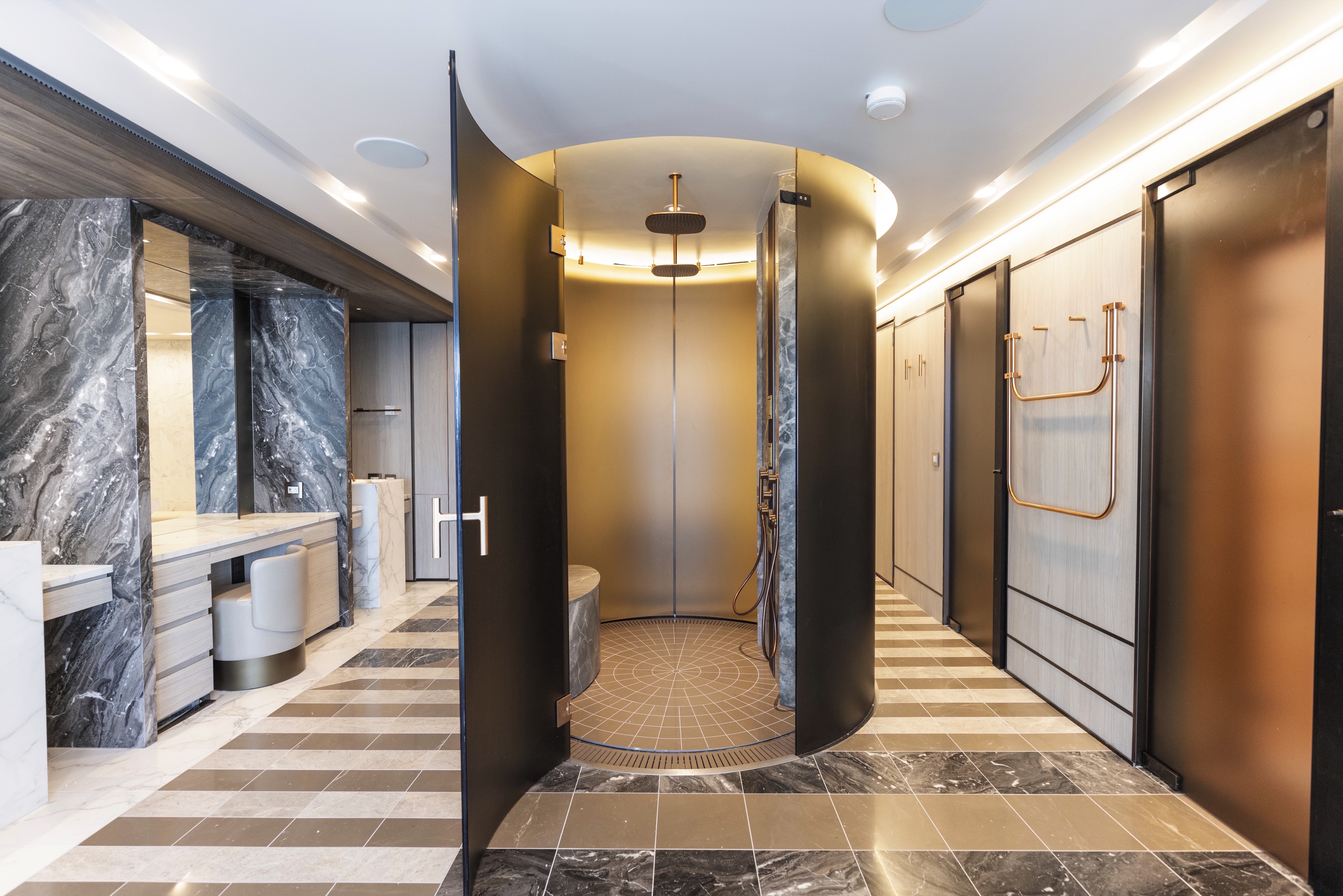
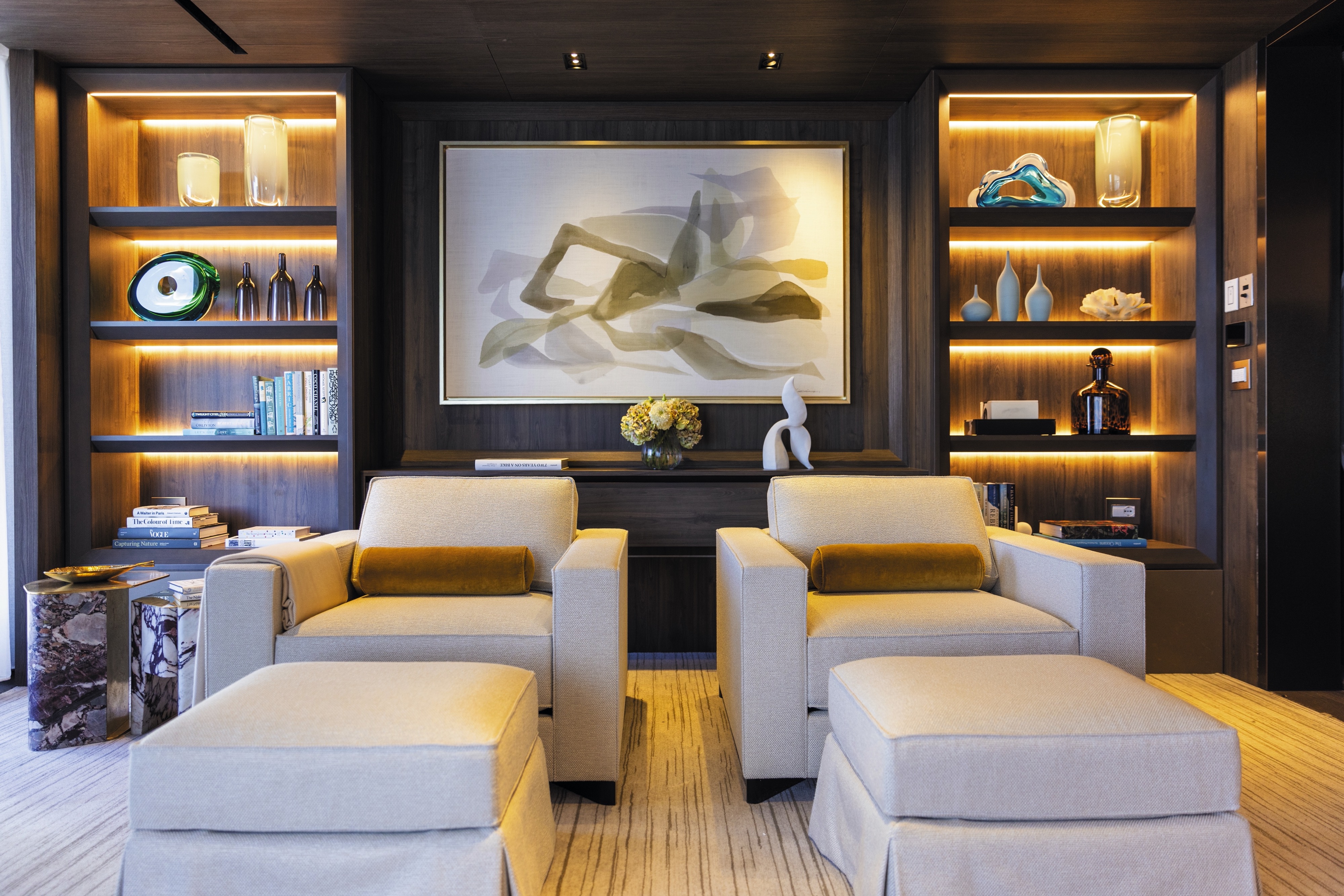
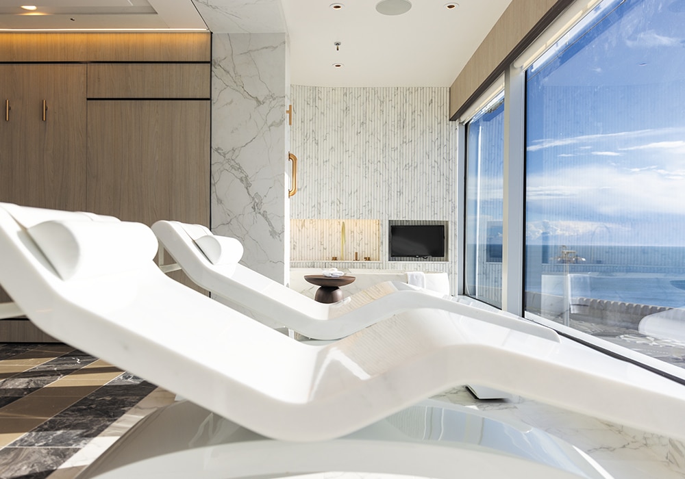
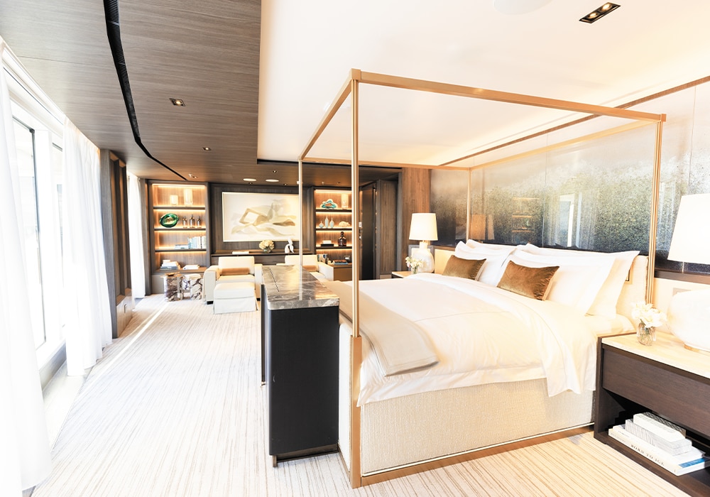
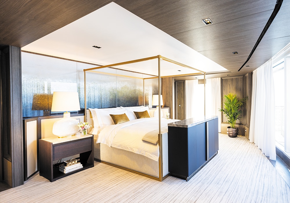
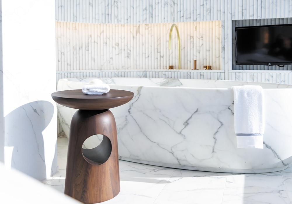
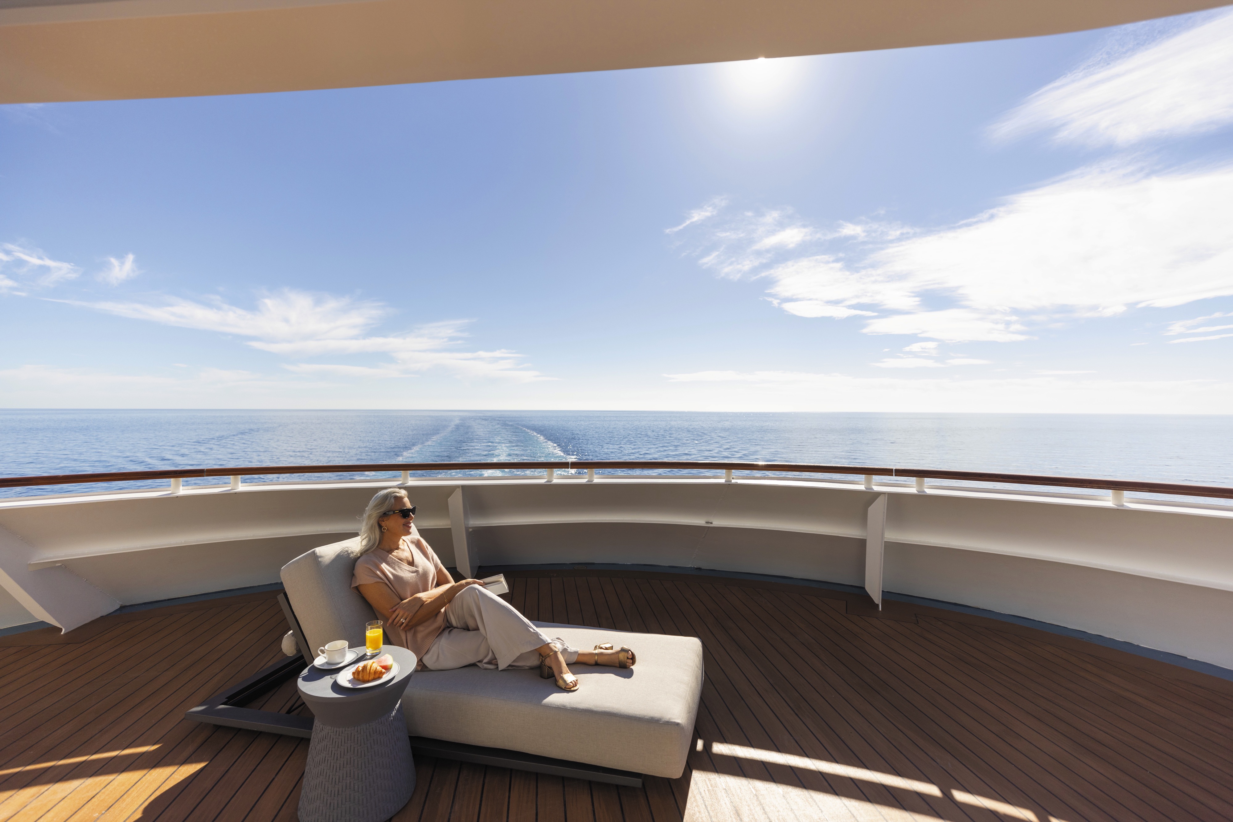
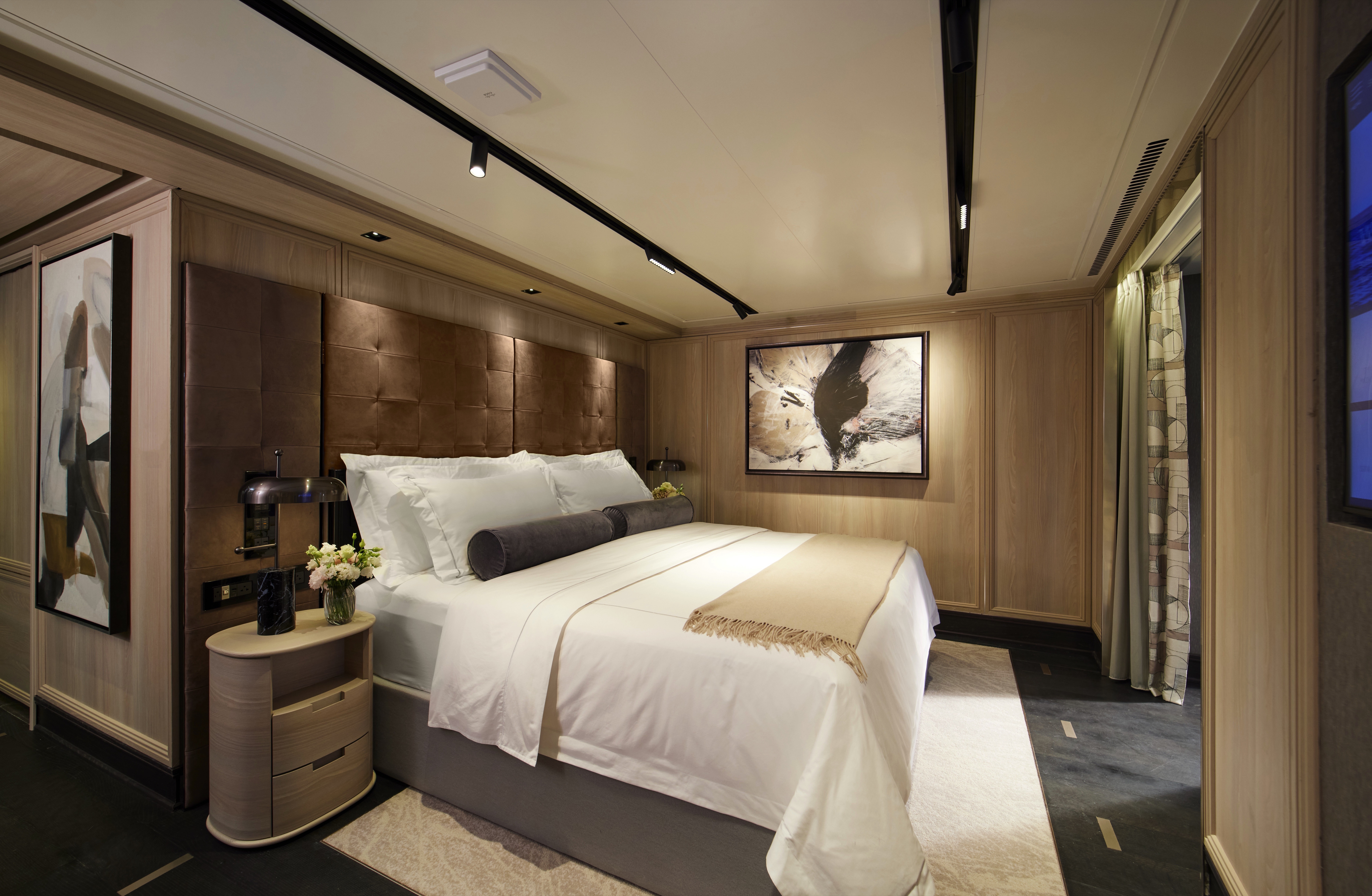
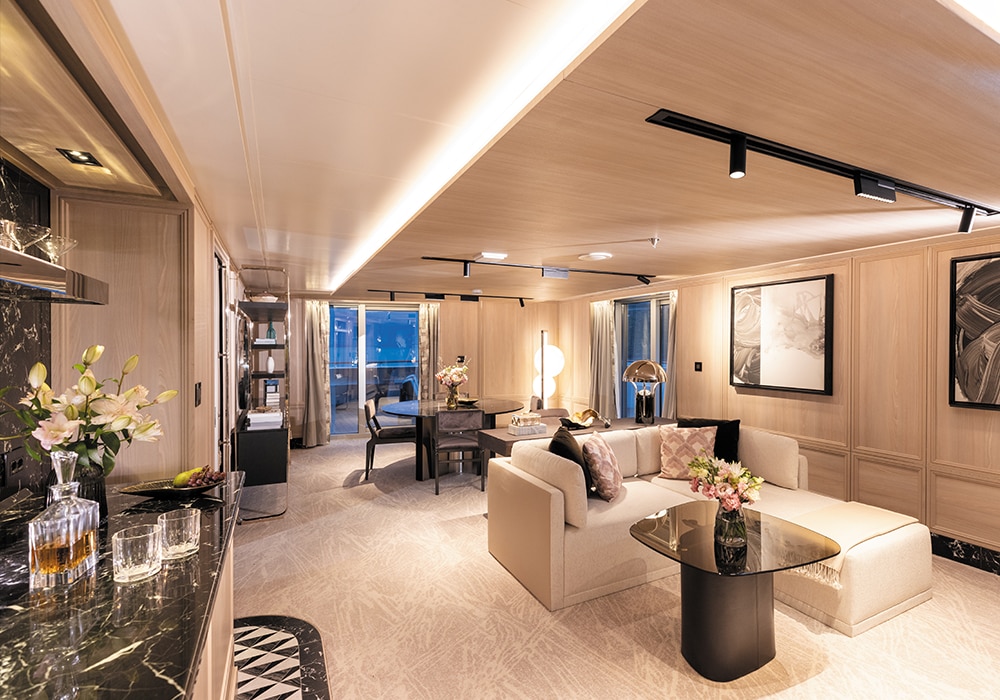
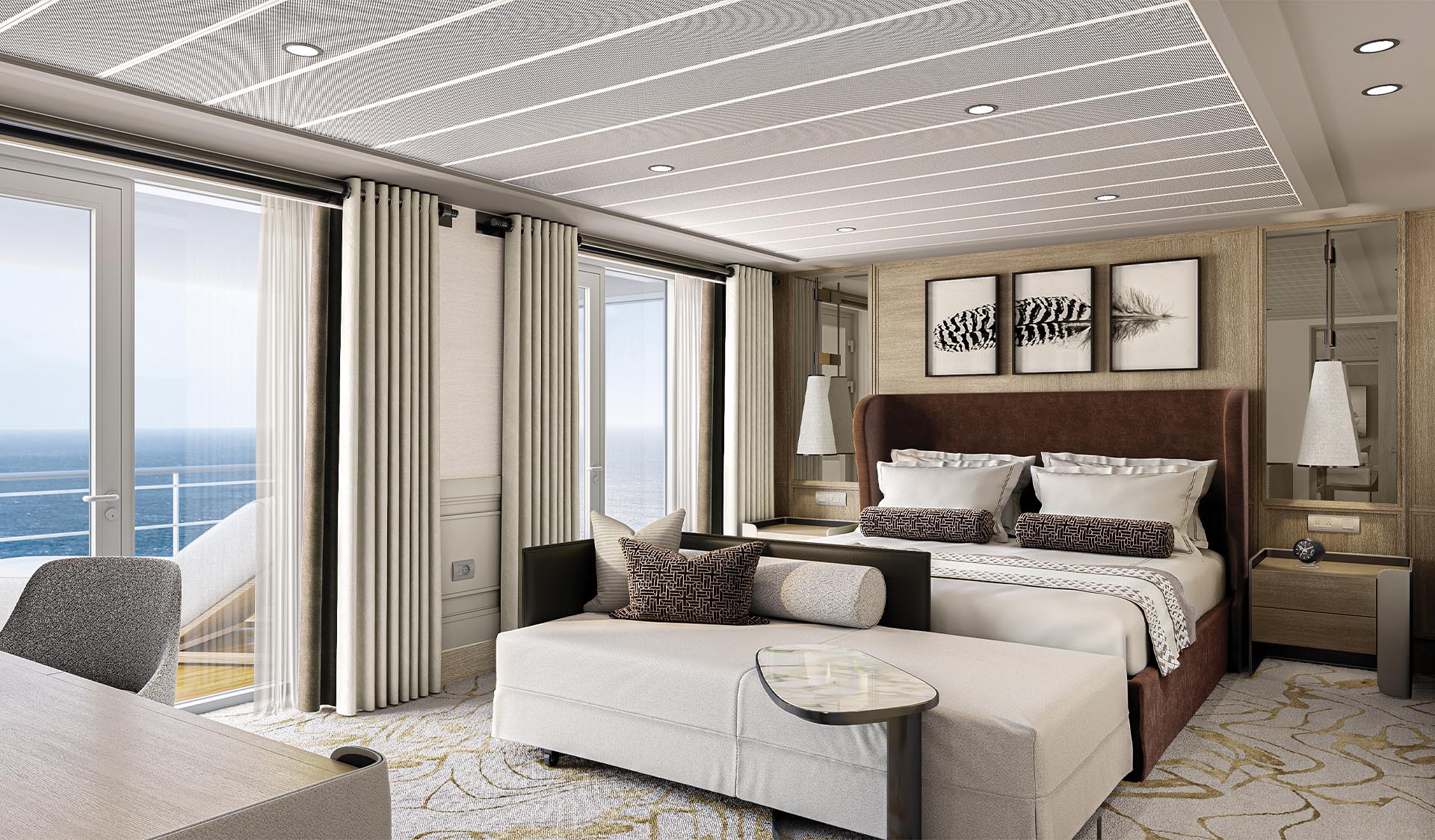
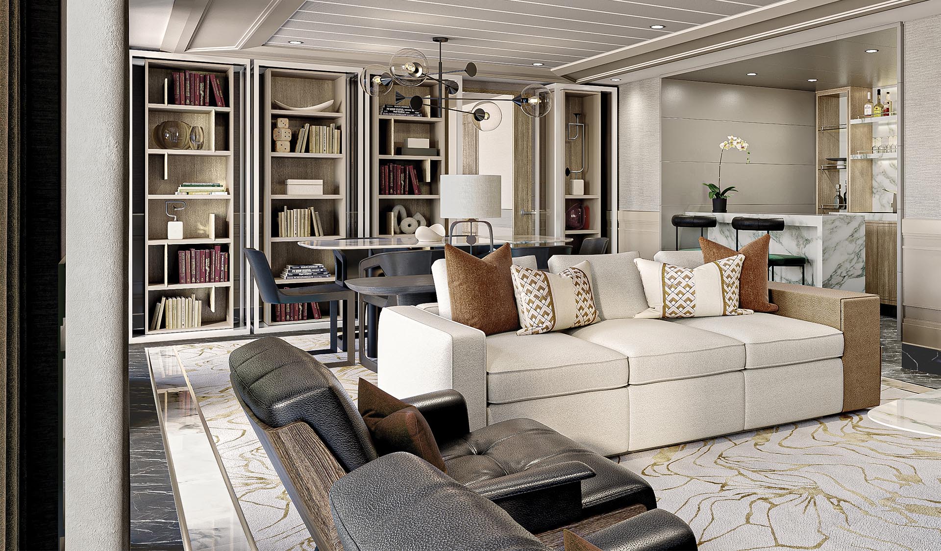
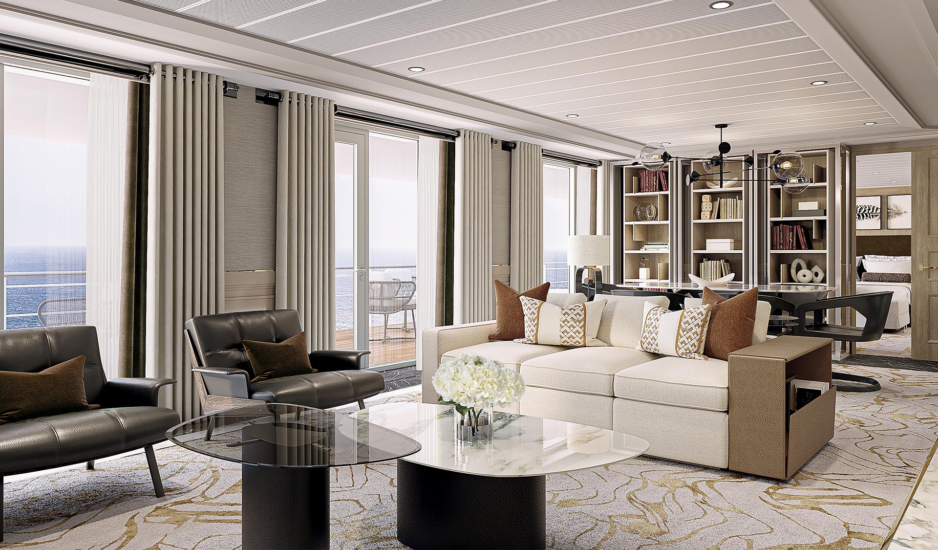
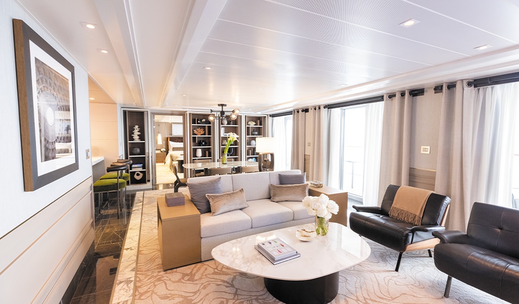
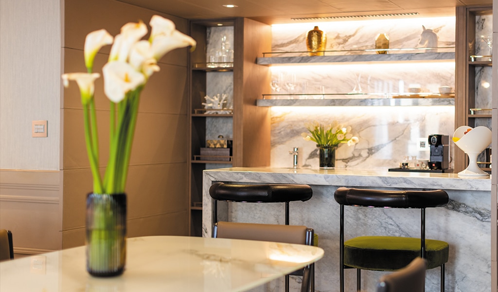
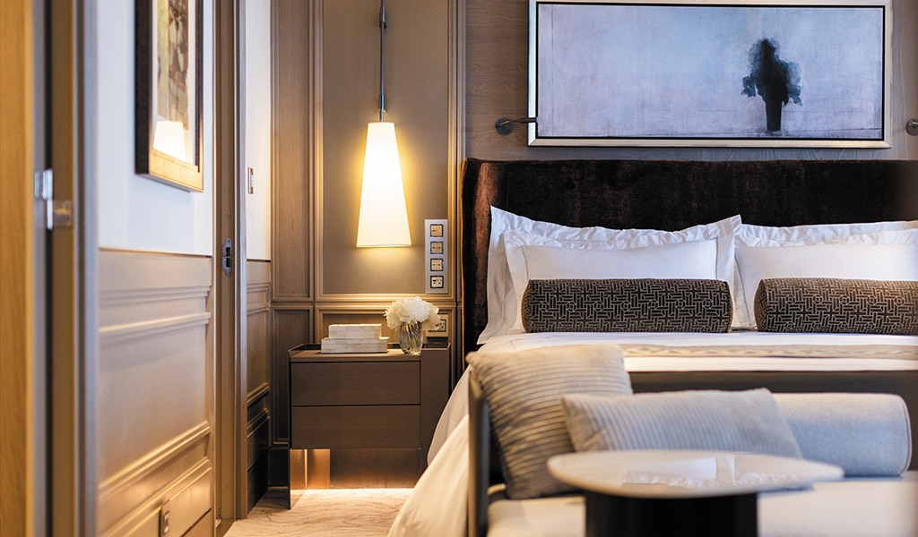
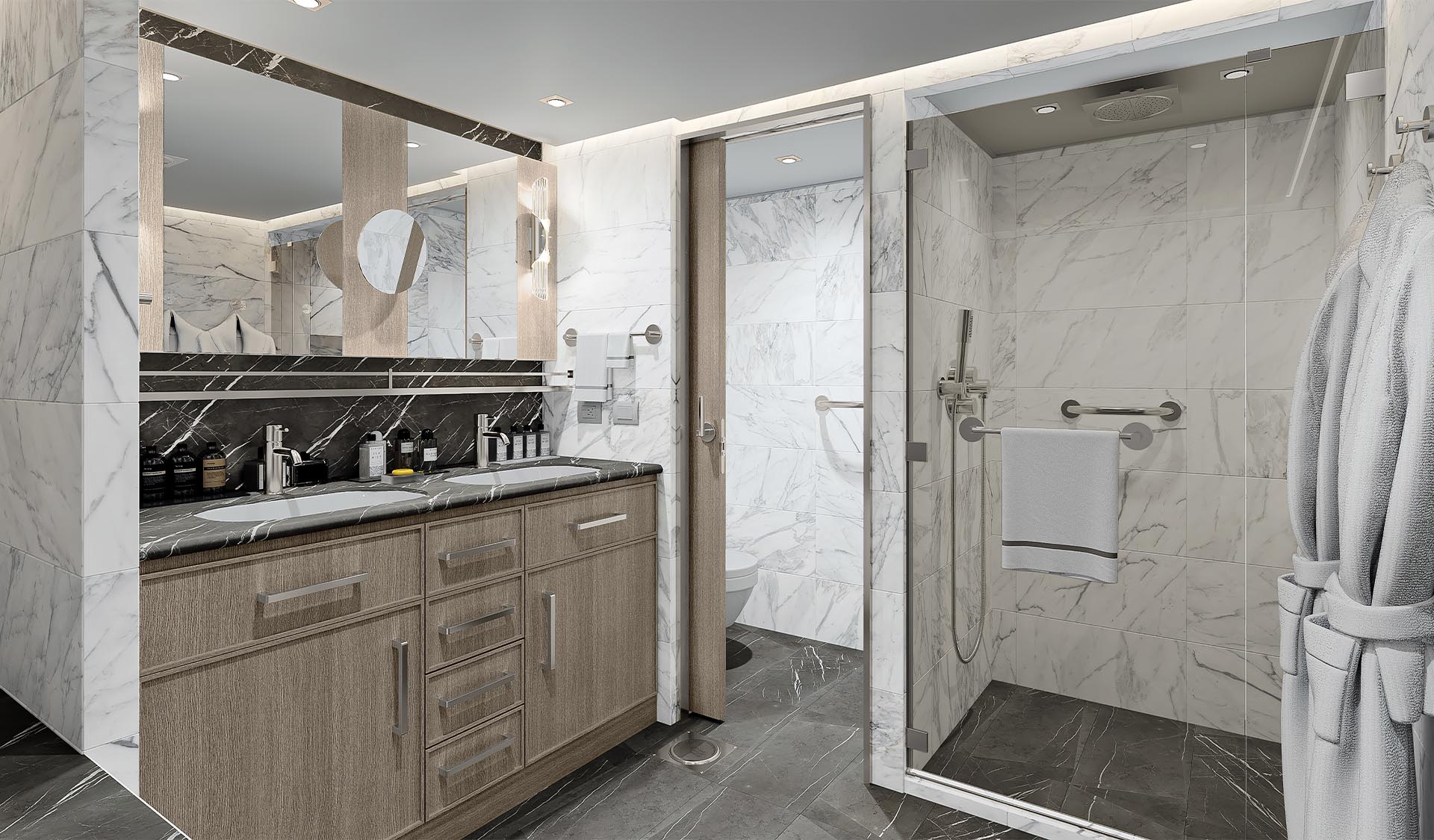
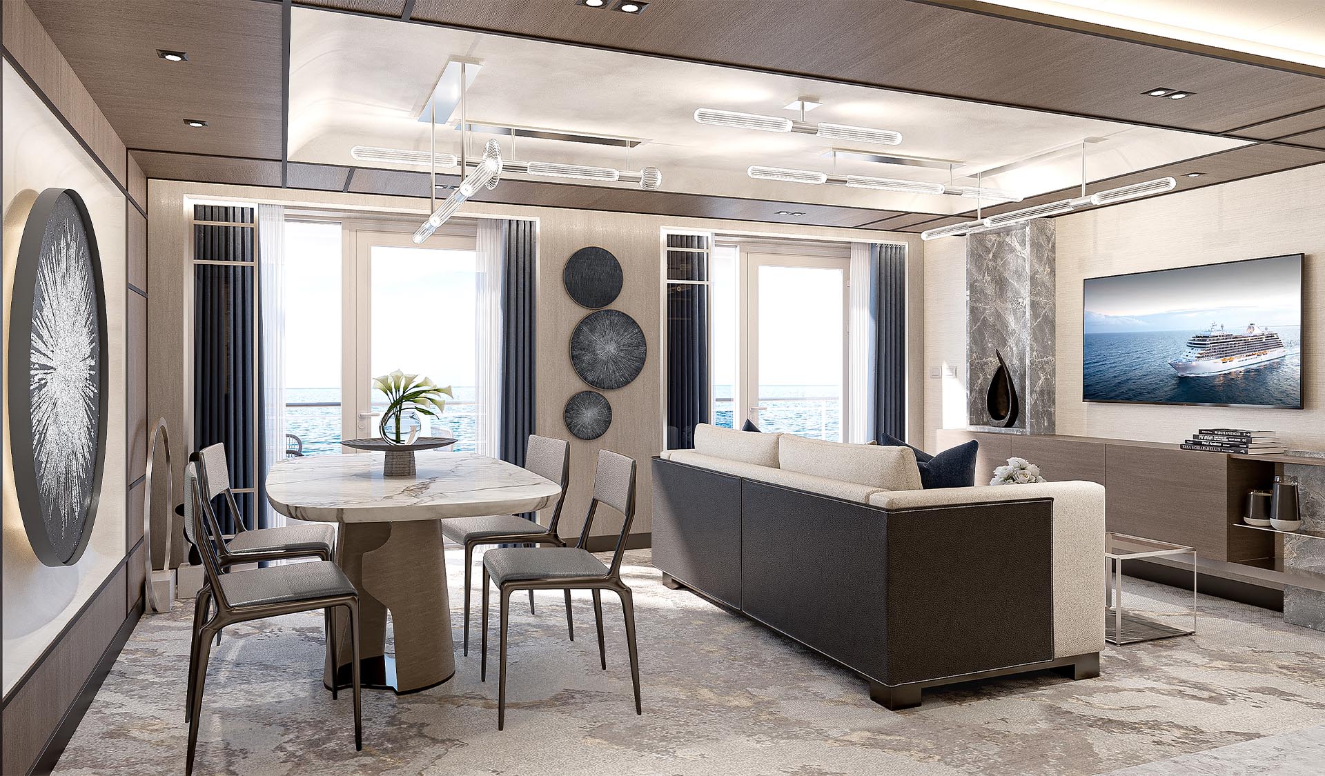
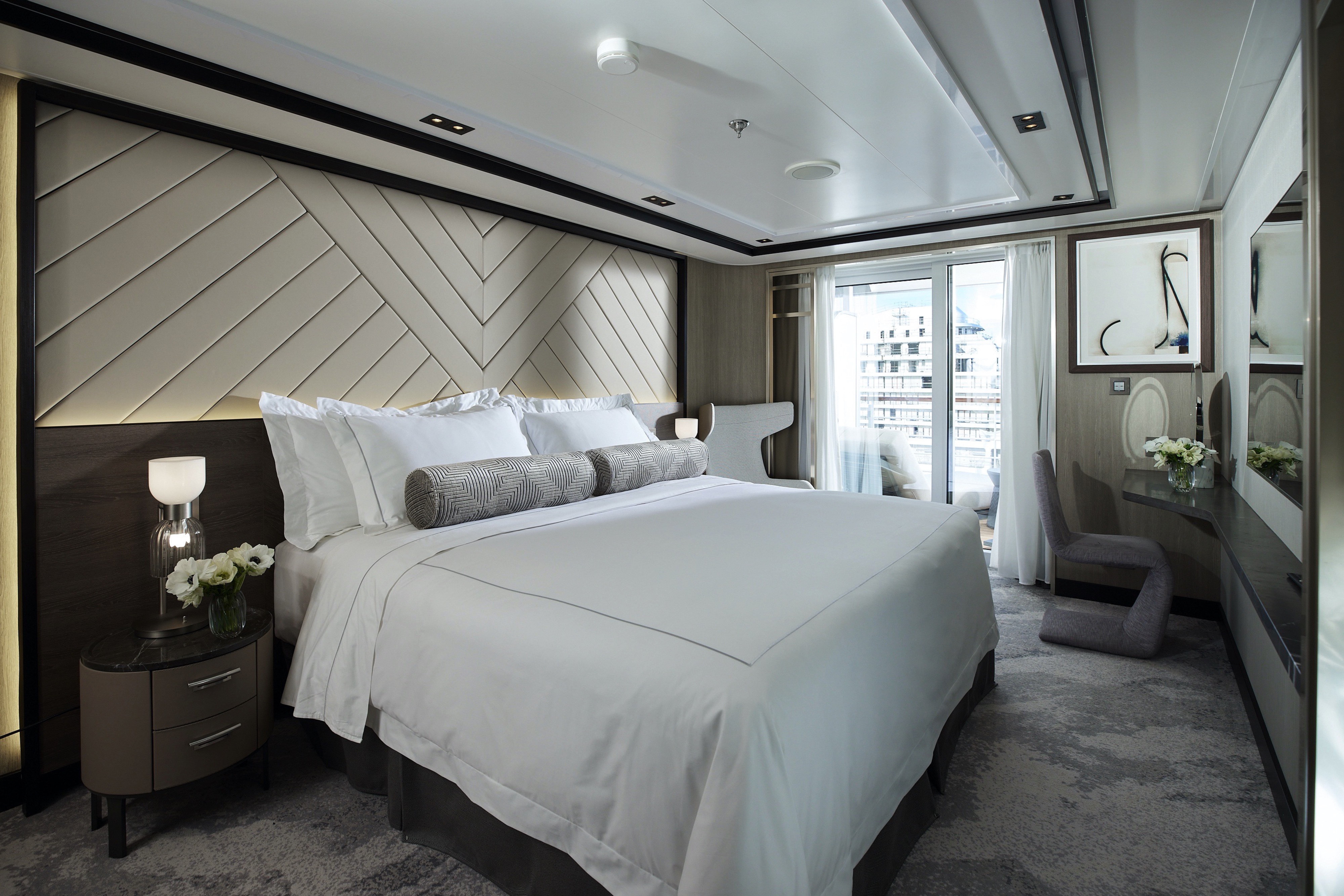
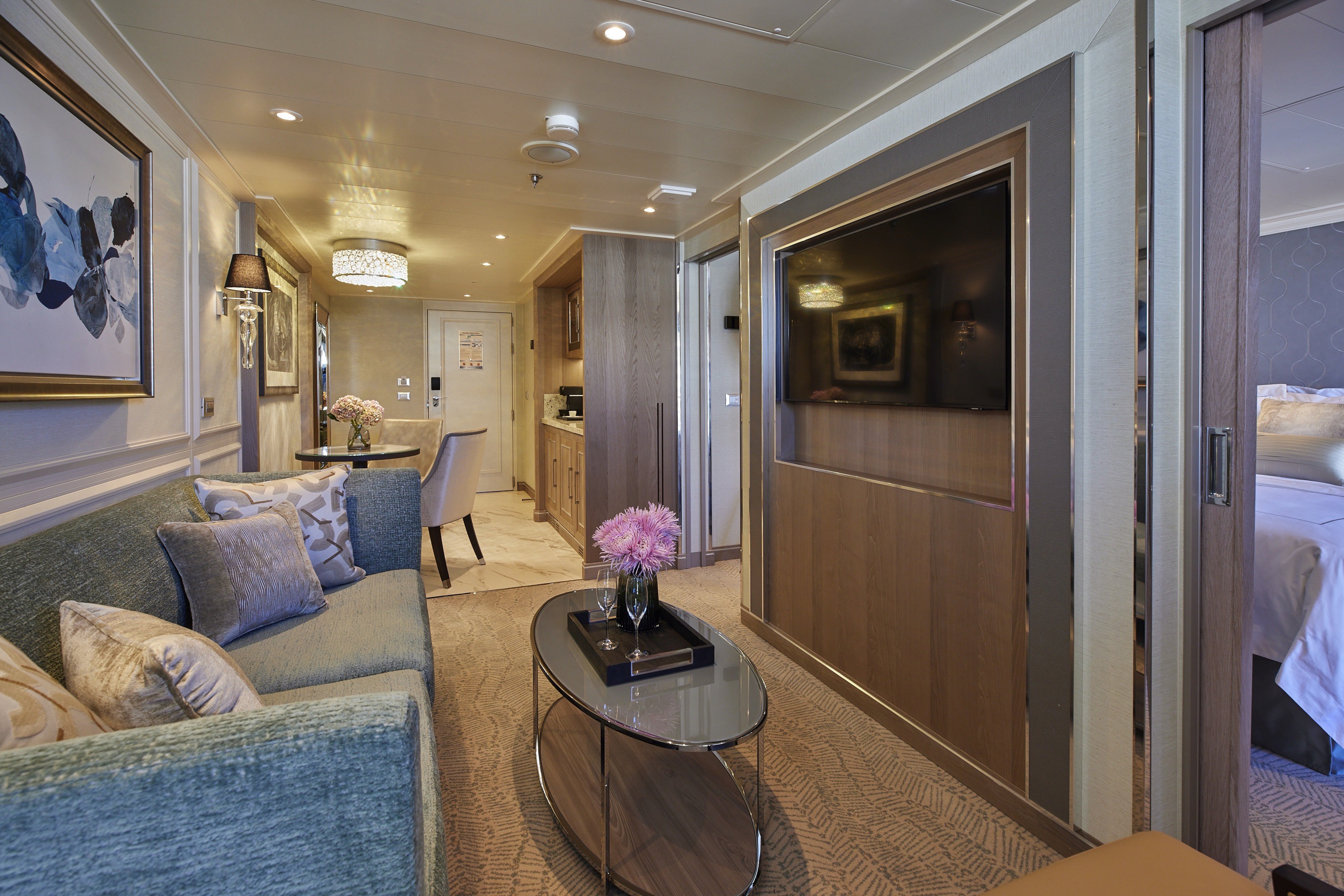
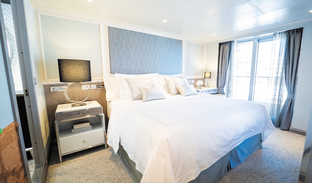
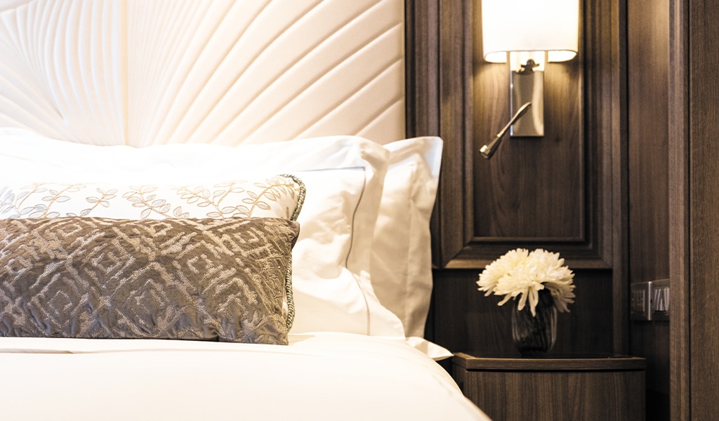
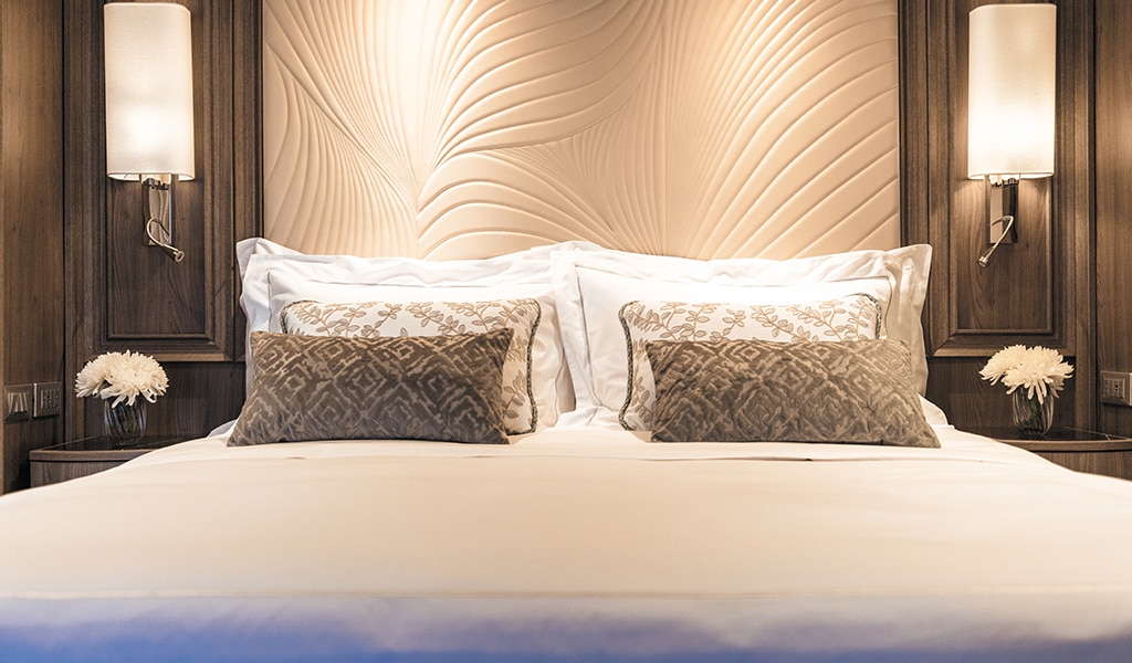
A one-of-a-kind achievement in lavish accommodations, this unparalleled suite boasts an in-suite spa retreat, private balcony with a Treesse Minipool, two magnificent bedrooms and more. Simply astonishing luxury.
Layout
- 2 Spacious Bedrooms with King-Size Ḧastens Vividus Bed in Primary Bedroom (*Bed in primary bedroom cannot be converted into two beds.)
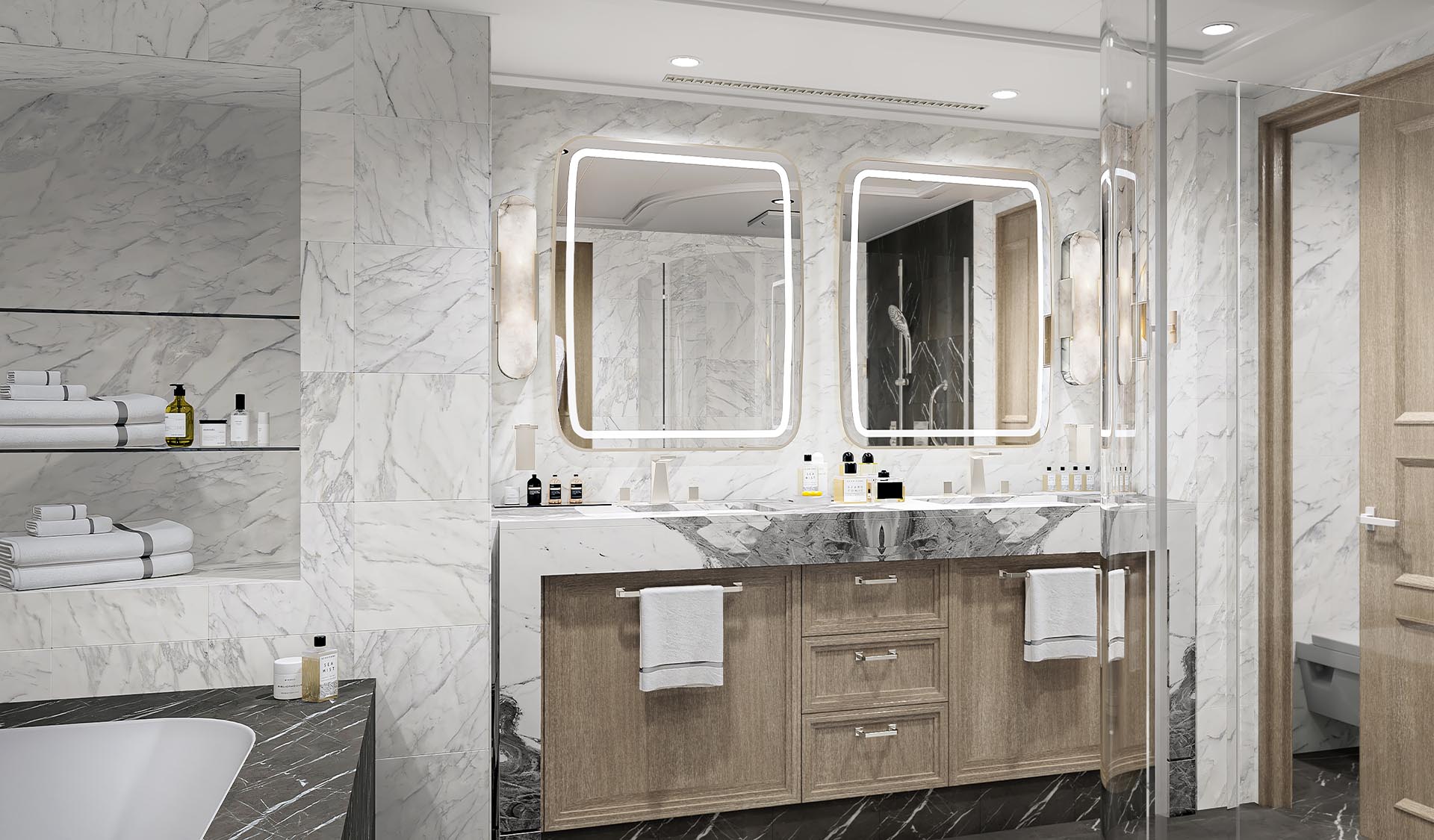
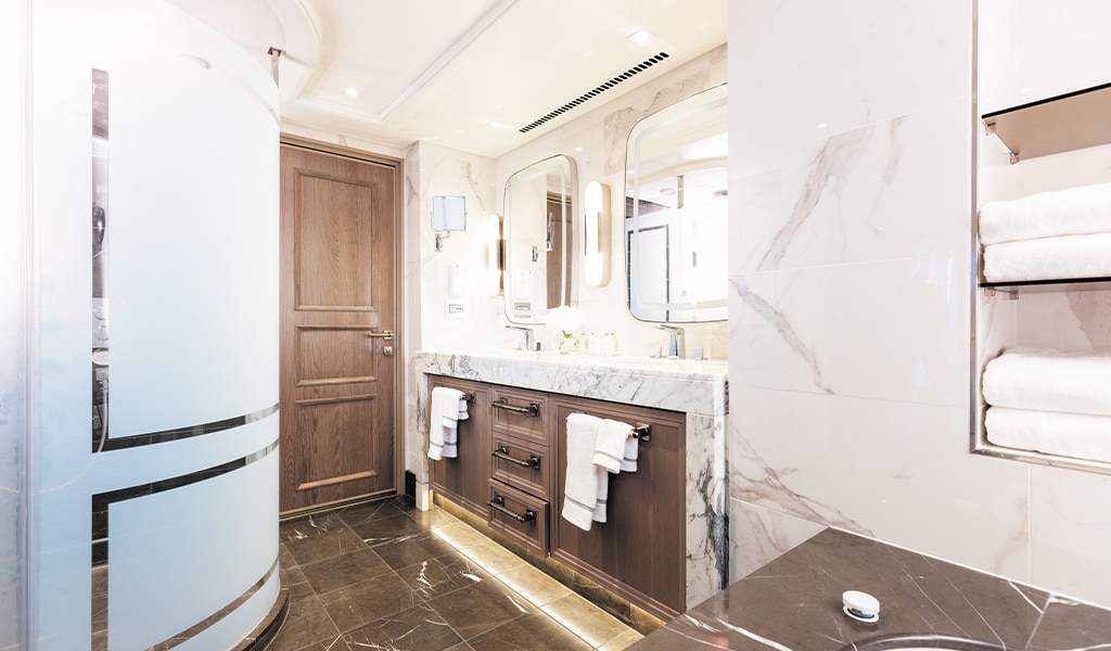
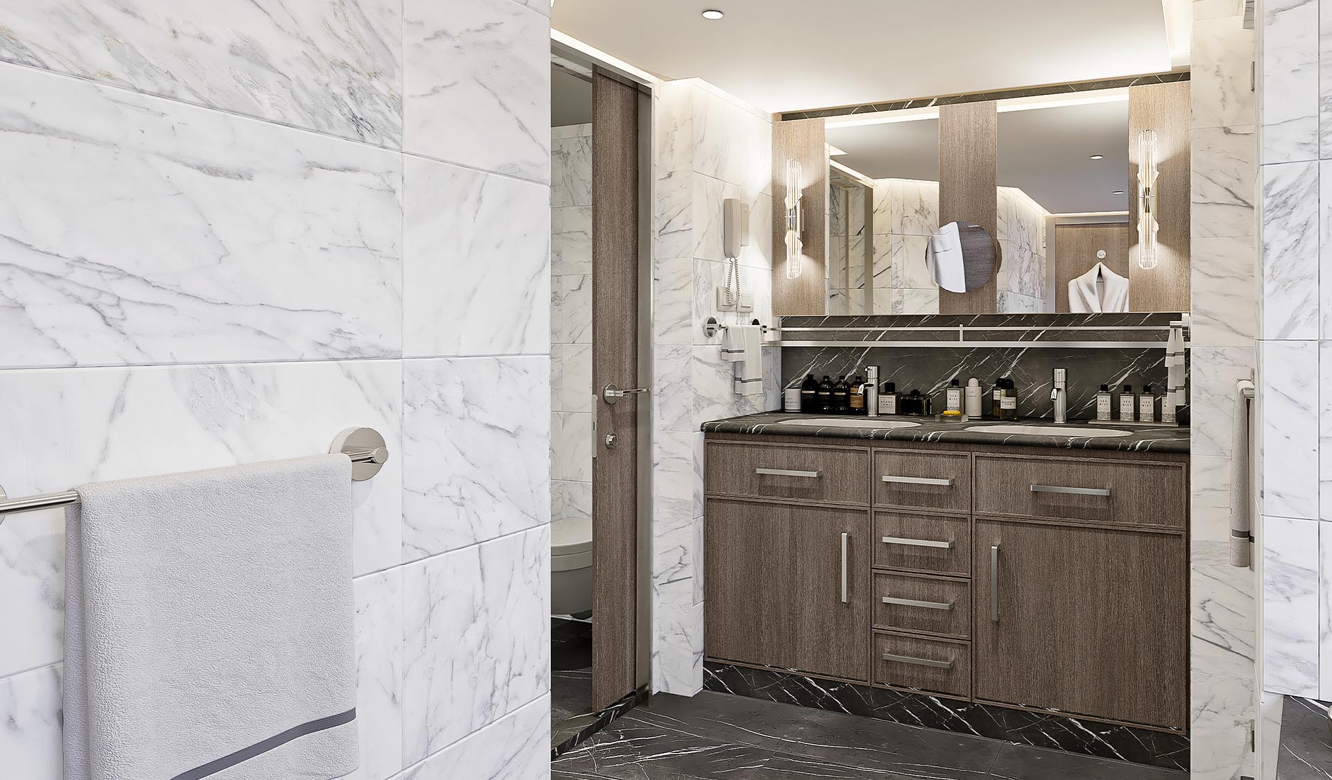
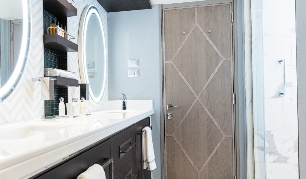
- 2 1/2 Marble & Stone Detailed Bathrooms, 1 with Jetted Tub
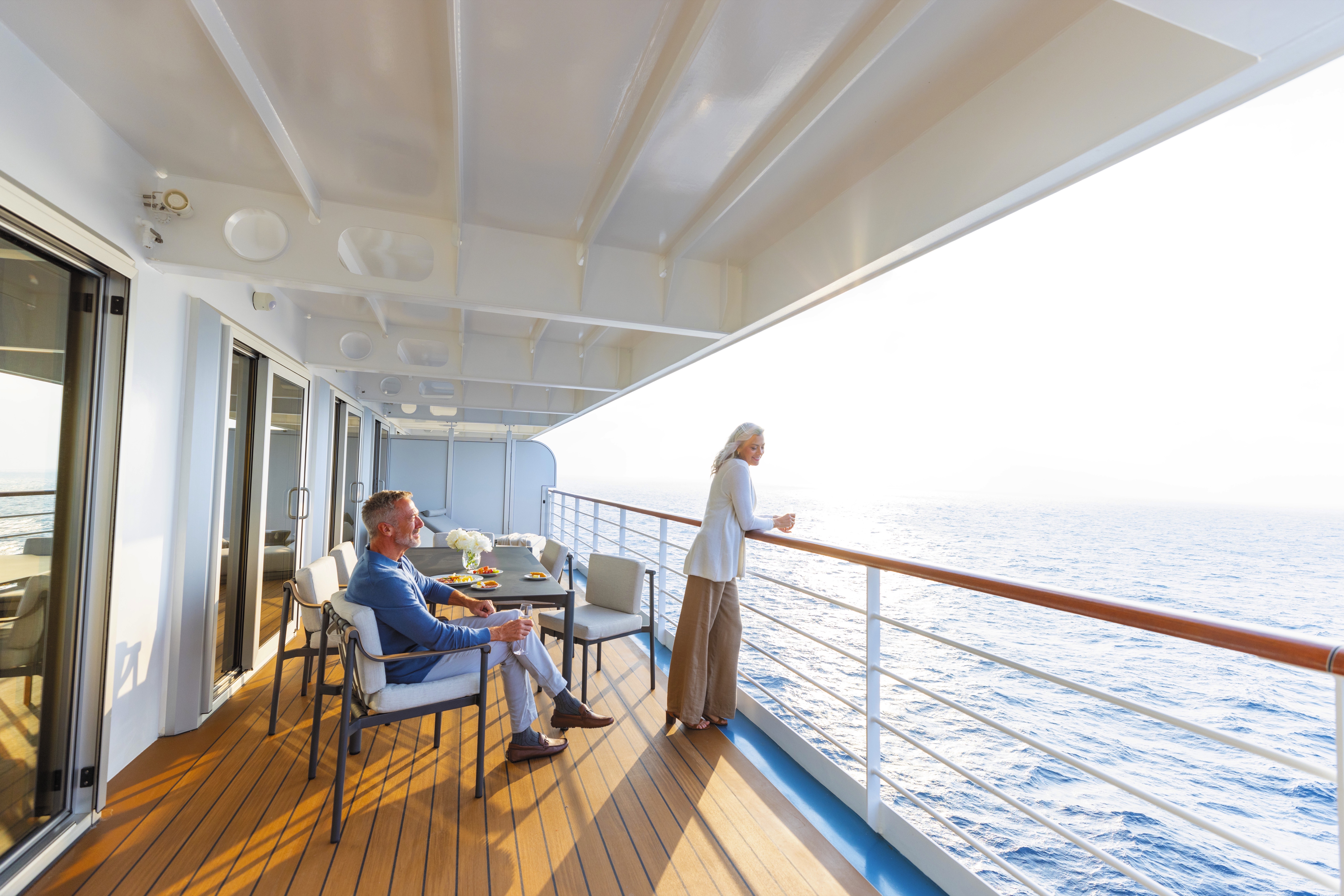
- 2 Private Balconies with Heated Minipool Spa
- Private In-Suite Spa with Sauna, Steam Room & Jacuzzi
- Spacious Living Room
- Skylight Parlor Area
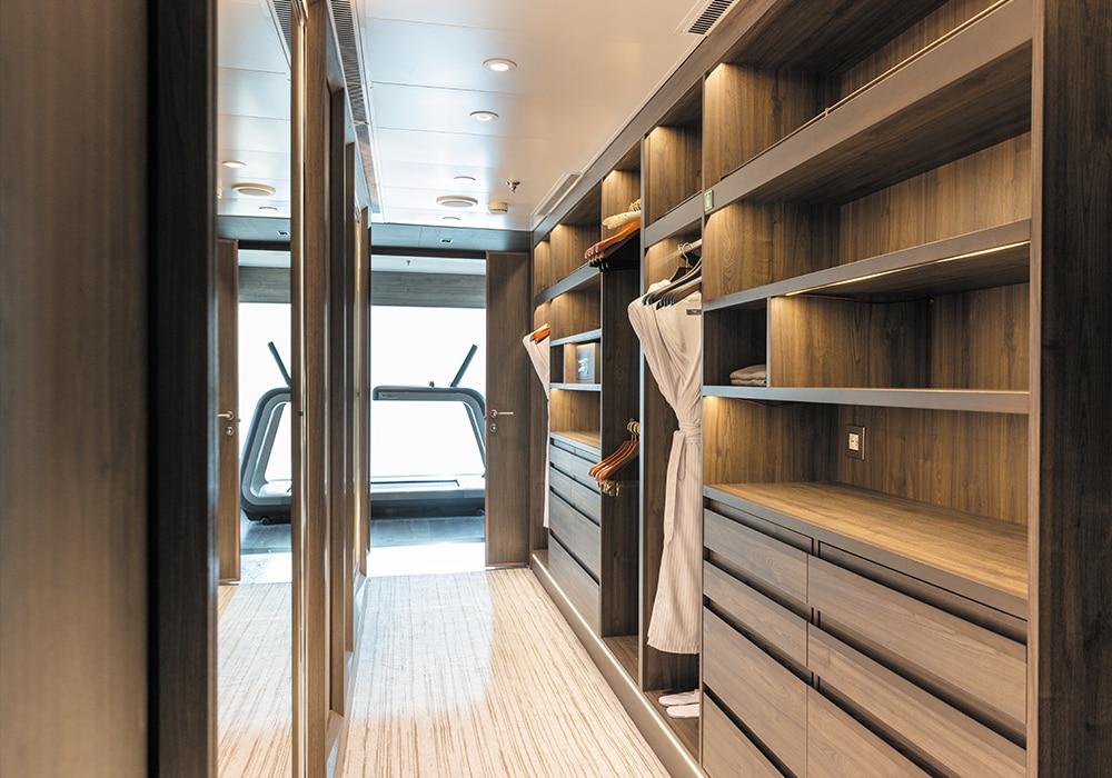
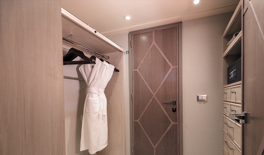
- 3 Walk-In Closets with 2 Safes
- Glass-Enclosed, Ocean-View Shower & Spa
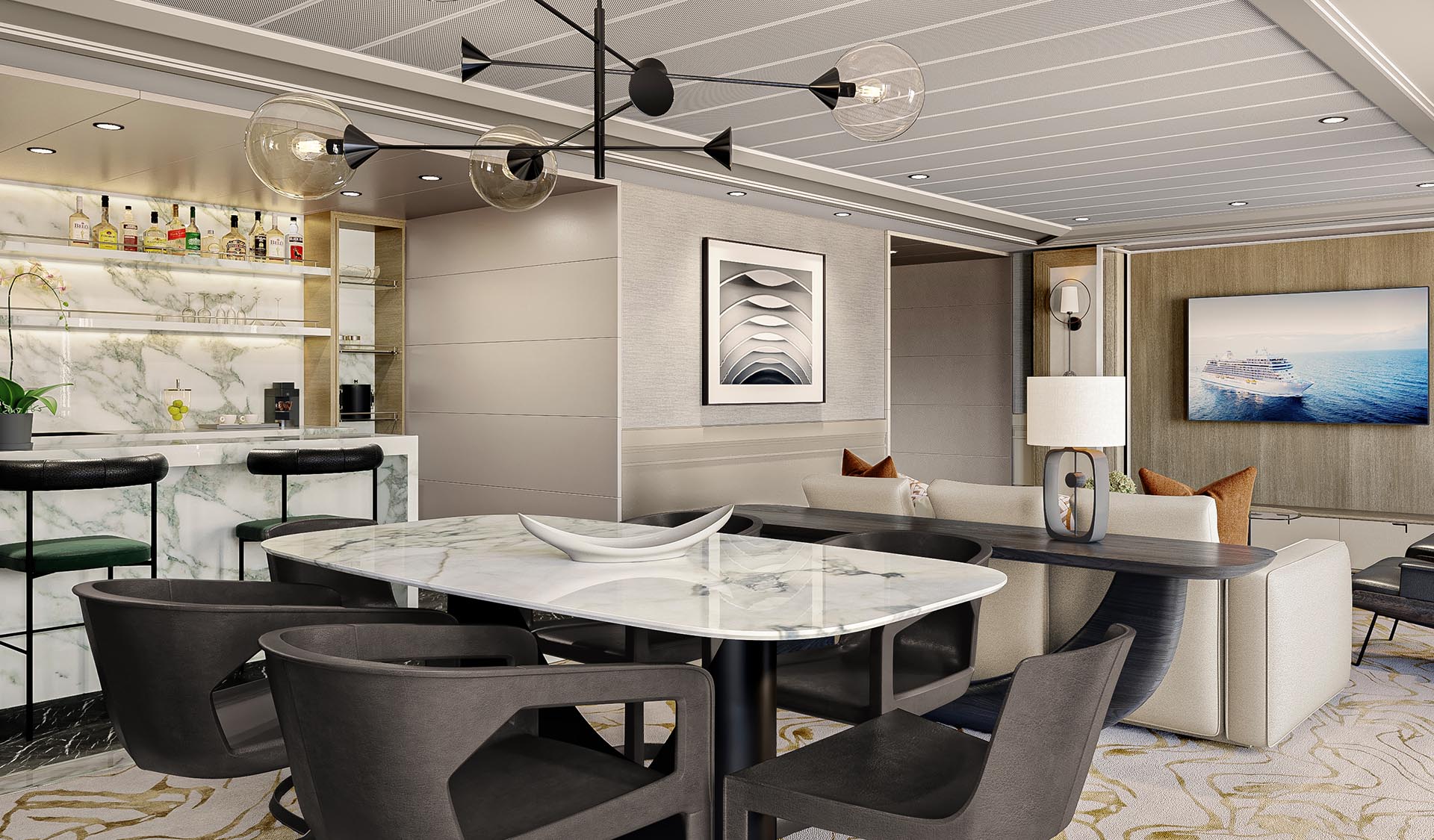
- Private, Separately Located Dining Room for Up to 12 Guests
- Includes Up To 6 GuestsThe suite pictured may differ from the suite booked, as layouts and designs vary by ship, deck, and suite location.
Amenities
- 1-Night Pre-Cruise: Hotel Package Including:
- - Breakfast
- - Porterage
- Unlimited WiFi* and Streaming Package for up to Four Devices
- Valet Laundry Service
- 24-hour In-Suite Dining
- Fresh Orchid Arrangement
- Regent Plush Bathrobe & Slippers
- Interactive Flat-Screen Television & Direct-Dial Satellite Phone
- Priority Access to Online Shore Excursion Reservations
- Priority Access to Online Dining Reservations
- Binoculars
- illy® Espresso Maker
- Cashmere Blankets
- Regent Special Gift
- Vanity & Hair Dryer
- Shoe Shine Service
- Additional Discounts:
- - 10% Discount on Ultra Premium Wine and Liquor
- - 5% Savings on Pre- or Post-Cruise Hotel or Land Programs
- - 5% Savings on Regent Choice Shore Excursions
- Additional Regent Suites Amenities:
- Personal Car & Guide to Explore Ashore
- Dedicated Private Travel Experiences Concierge from Knightsbridge Circle
- Two Daily Serene Spa & Wellness™ Services with Priority Reservations per Suite
- Access to The Study, a Private Dining Room for up to 12 Guests
- Unlimited Dry Cleaning
- Guaranteed Reservation Each Night in Specialty Restaurant of Your Choice
- Welcome Letter from the President and General Manager
- Personal Butler for an Elevated In-suite Experience
- - In-Suite Dining Menu Including Specialty Restaurant Selections During Dining Hours
- Priority Boarding on Embarkation Day with Suite Access at Noon
- Marzotto Cristallo Silk & Cashmere with Fringe Throw
- Welcome Bottle of Dom Pérignon Champagne
- Remy Martin Louis XIII Cognac 50ml
- Personalized In-Suite Full-Liquor Bar Set-Up
- A Sumptuous In-Suite Caviar Service Once During Cruises
- Complimentary In-Suite Cocktail Party for 8
- Complimentary 25-Minute Personal Fitness Session at the Serene Spa & Wellness™ Fitness Center
- Daily Canapés
- Tea Forté Set-Up
- Luxe Fruit Arrangement with Chocolate Leonidas
- Choice of Luxurious Designer Bath Amenities
- Spa Accessories & Spongology Collection
- Dyson Hairdryer
- Selection of Fig & Tea Leaves Bath Salts
- Guerlain Bath Amenities & Men's Unscented Shaving Kit
- Wallet Make Up Brush Set / Hairbrush & Combo Set
- Bose® SoundLink Mini II Bluetooth Speaker
- Selection of Bed Pillow Styles
- Linen Menu
- Complimentary Garment Pressing on First Night
- Personalized Stationery upon request
- Elegant Weather Clock
- Excursion Bag
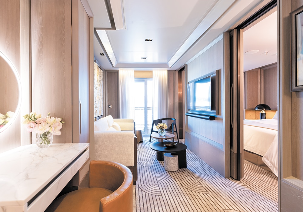
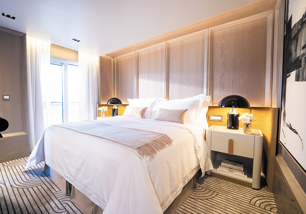
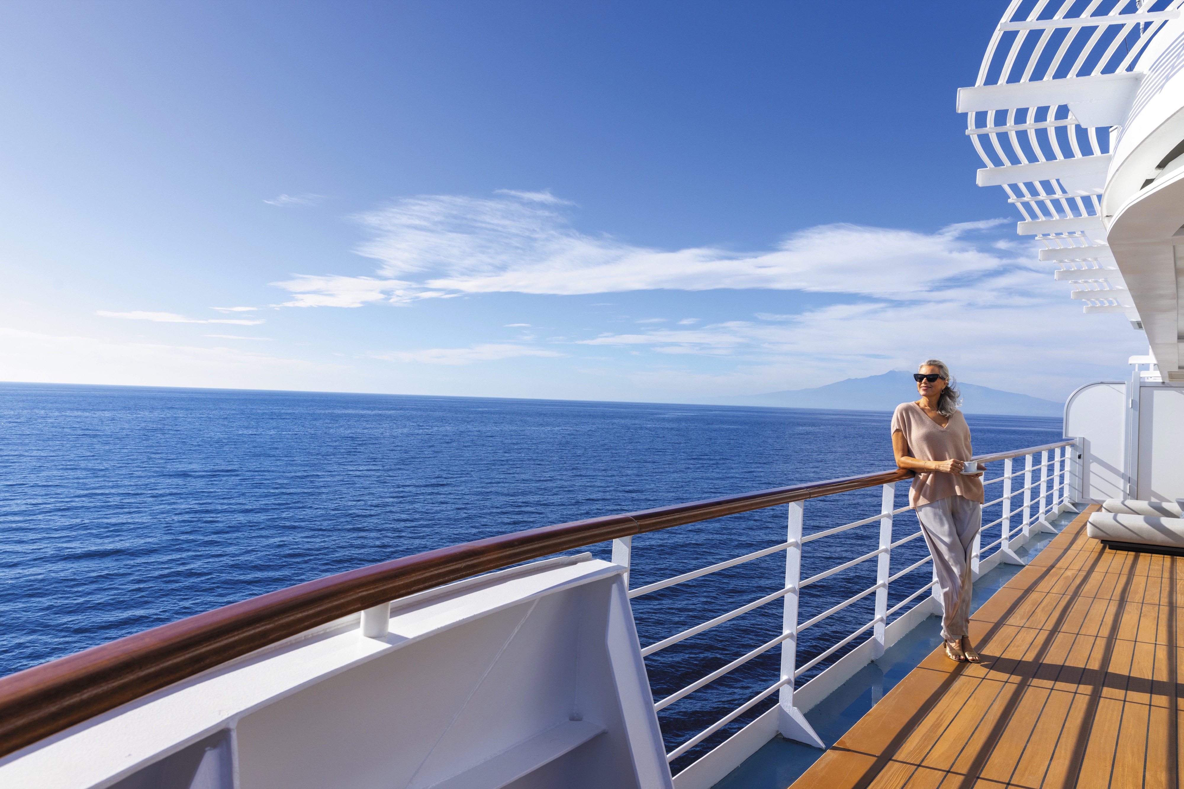
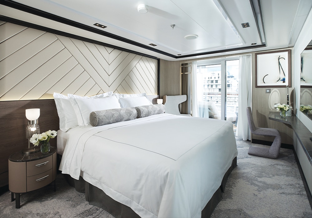
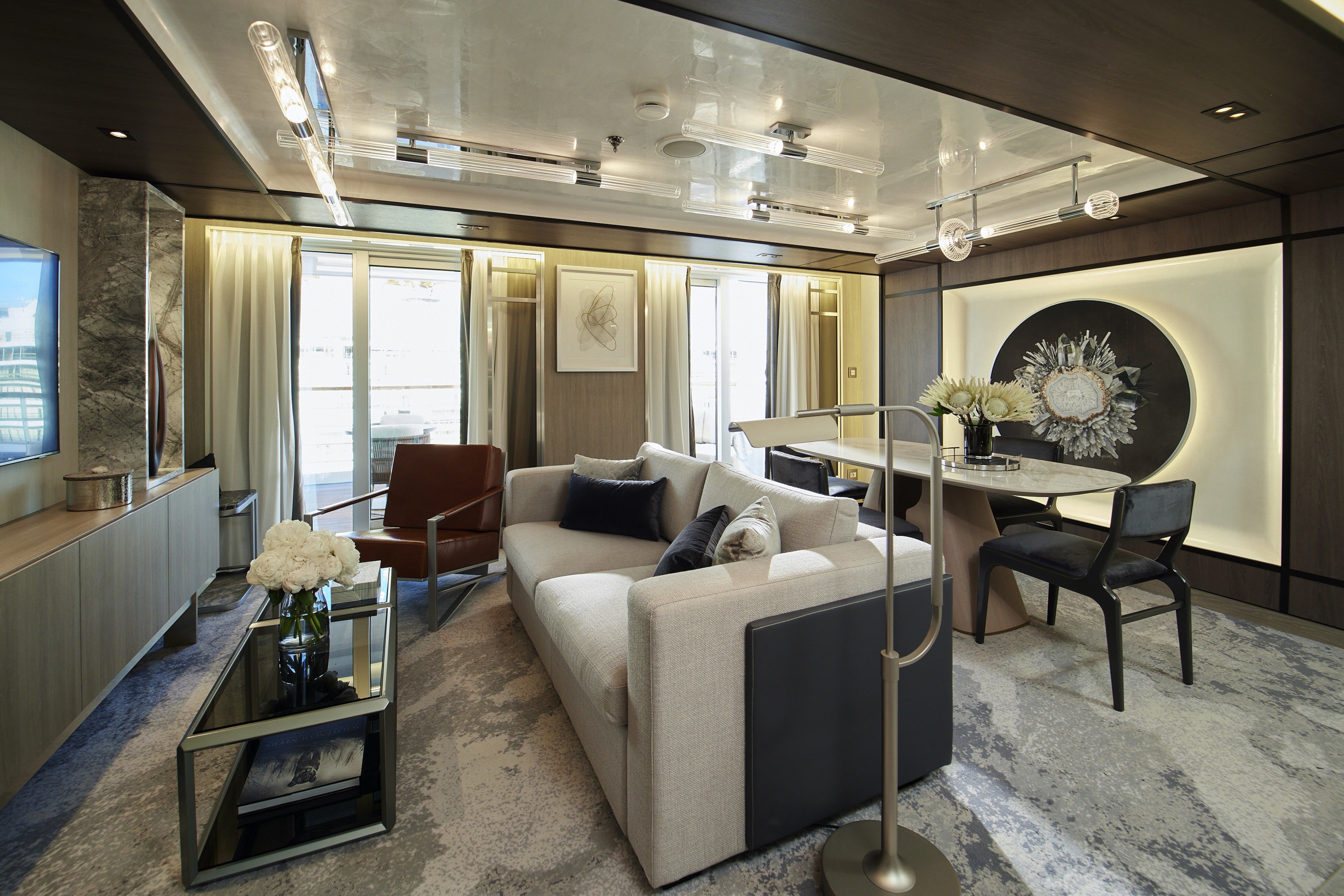
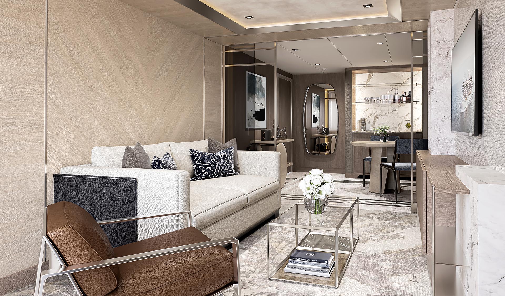
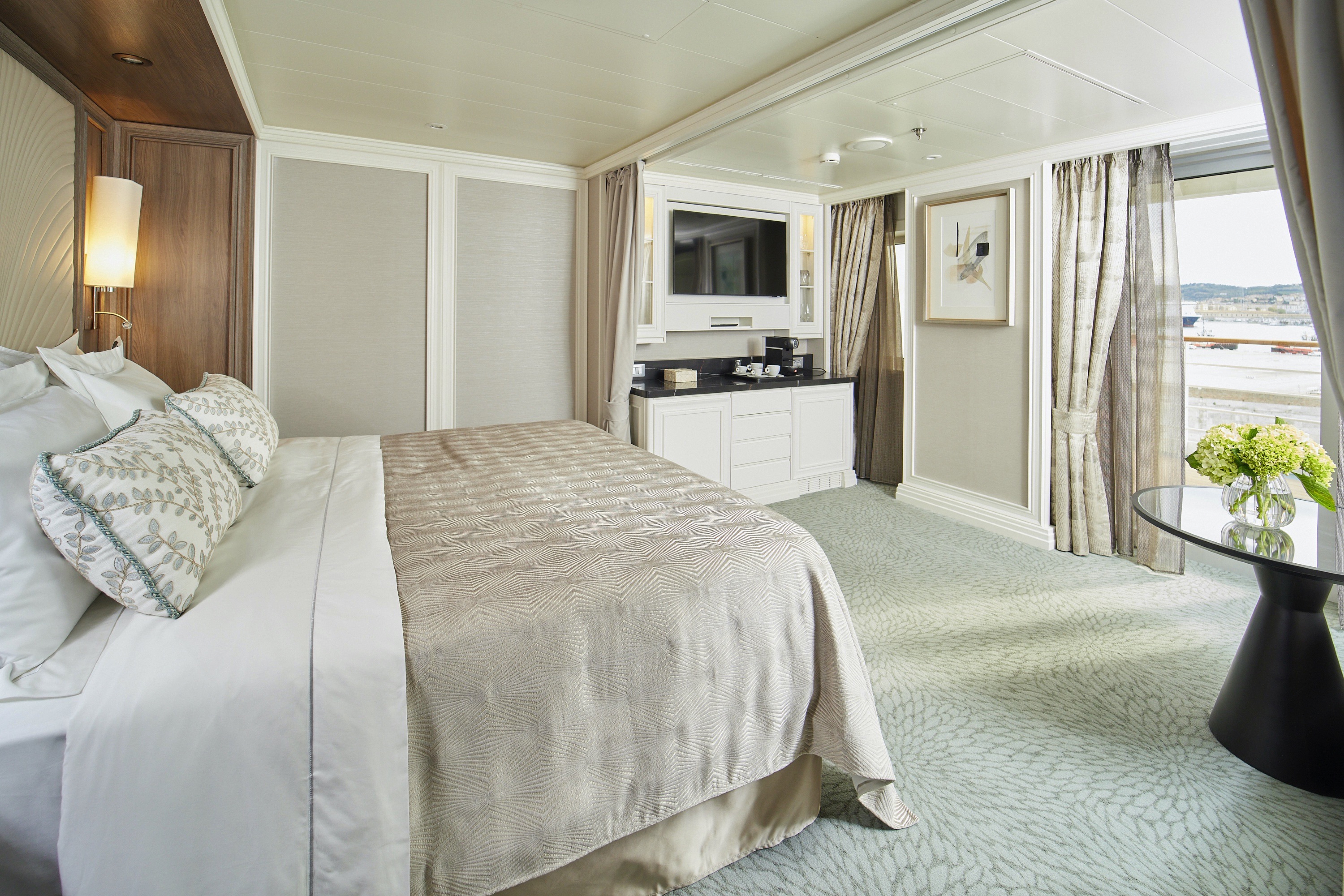
A rich colour palette and the finest fabrics create sophisticated comfort and a true urban chic. Plenty of space, including a large living room and a wrap-around private balcony, makes entertaining a breeze.
Layout
- 2 Spacious Bedroom with a European King-Size Elite Slumber® Bed (*Bed in primary bedroom cannot be converted into two beds.)
- 2 Marble & Stone Detailed Bathrooms
- Private Balcony
- Sitting Area
- Walk-In Closet with Safe
- Includes Up To 6 Guests
The suite pictured may differ from the suite booked, as layouts and designs vary by ship, deck, and suite location.
Amenities
- 1-Night Pre-Cruise: Hotel Package Including:
- - Ground Transfers
- - Breakfast
- - Porterage
- Unlimited WiFi and Streaming Package for up to Four Devices
- Valet Laundry Service
- 24-hour In-Suite Dining
- Fresh Orchid Arrangement
- L'Occitane® Jasmin & Bergamot Bath Amenities
- Regent Plush Bathrobe & Slippers
- Interactive Flat-Screen Television & Direct-Dial Satellite Phone
- Priority Access to Online Shore Excursion Reservations
- Priority Access to Online Dining Reservations
- Binoculars
- illy® Espresso Maker
- Cashmere Blankets
- Regent Special Gift
- Vanity & Hair Dryer
- Shoe Shine Service
- Additional Discounts:
- - 10% Discount on Ultra Premium Wine and Liquor
- - 5% Savings on Pre- or Post-Cruise Hotel or Land Programs
- - 5% Savings on Regent Choice Shore Excursions
Additional Signature Suite Amenities:
- VIP Status Including Dinner with a Senior Officer
- Guaranteed Reservation Each Night in Specialty Restaurant of Your Choice
- Welcome Letter from the President and General Manager
- Personal Butler for an Elevated In-suite Experience
- - In-Suite Dining Menu Including Specialty Restaurant Selections During Dining Hours
- Priority Boarding on Embarkation Day with Suite Access at Noon
- Marzotto Cristallo Silk & Cashmere with Fringe Throw
- Welcome Bottle of Premium Champagne
- Personalized In-Suite Full-Liquor Bar Set-Up
- A Sumptuous In-Suite Caviar Service Once During Cruises
- Complimentary In-Suite Cocktail Party for 8
- Complimentary 25-Minute Personal Fitness Session at the Serene Spa & Wellness™ Fitness Center
- Daily Canapés
- Tea Forté Set-Up
- Luxe Fruit Arrangement with Chocolate Leonidas
- Luxurious Designer Bath Amenities & Men's Unscented Shaving Kit
- Guerlain Box with Fragrance & Spongellé Buffer
- Dyson Hairdryer
- Selection of Fig & Tea Leaves Bath Salts
- Guerlain Bath Amenities & Men's Unscented Shaving Kit
- Bath Scale Setup
- Bose® SoundLink Mini II Bluetooth Speaker
- Selection of Bed Pillow Styles
- Complimentary Garment Pressing on First Night
- Personalized Stationery upon request
- Elegant Weather Clock
- Excursion Bag
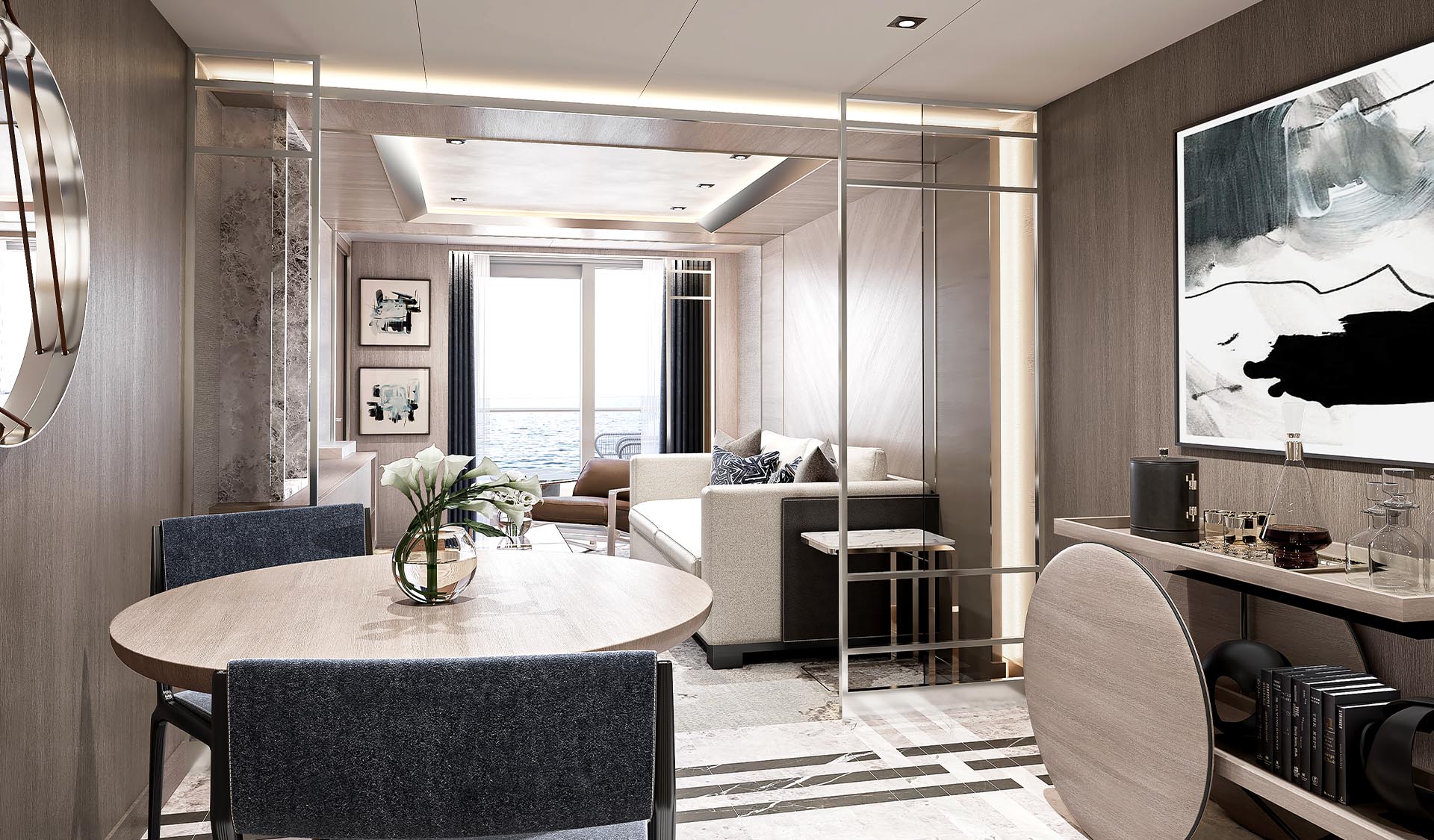
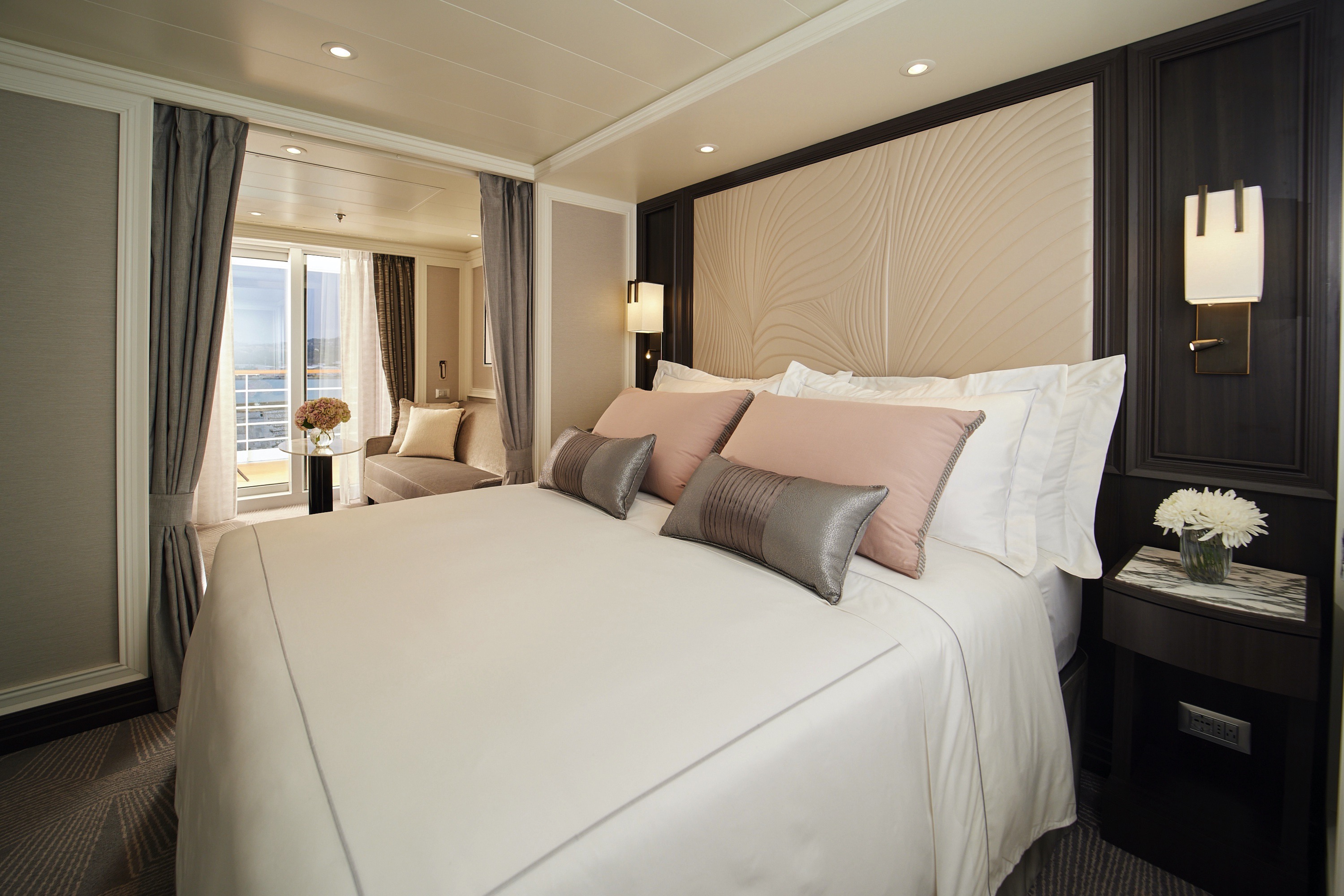
Experience the joy of sailing the world with an exquisitely designed space like this suite to call home throughout your voyage. Indulge in a sumptuous living room, two full baths, lavish bath products and a private balcony.
The suite pictured may differ from the suite booked, as layouts and designs vary by ship, deck, and suite location.
Layout
1 Spacious Bedroom with a European King-Size Elite Slumber® Bed (*Bed cannot be converted into two beds.)
- 2 Marble & Stone Detailed Bathrooms
- Private Balcony
- Sitting Area
- Walk-In Closet with Safe
- Accommodates Up To 3 Guests
- The suite pictured may differ from the suite booked, as layouts and designs vary by ship, deck, and suite location.
Amenities
- 1-Night Pre-Cruise: Hotel Package Including:
- - Ground Transfers
- - Breakfast
- - Porterage
- Unlimited WiFi Includes up to Four Logins, Four Devices, per Suite
- Valet Laundry Service
- 24-hour In-Suite Dining
- Fresh Orchid Arrangement
- L'Occitane® Jasmin & Bergamot Bath Amenities
- Regent Plush Bathrobe & Slippers
- Interactive Flat-Screen Television & Direct-Dial Satellite Phone
- Priority Access to Online Shore Excursion Reservations
- Priority Access to Online Dining Reservations
- Binoculars
- illy® Espresso Maker
- Cashmere Blankets
- Regent Special Gift
- Vanity & Hair Dryer
- Shoe Shine Service
- Additional Discounts:
- - 10% Discount on Ultra Premium Wine and Liquor
- - 5% Savings on Pre- or Post-Cruise Hotel or Land Programs
- - 5% Savings on Regent Choice Shore Excursions
- VIP Status Including Dinner with a Senior Officer
- Guaranteed Reservation Each Night in Specialty Restaurant of Your Choice
- Welcome Letter from the President and General Manager
- Personal Butler for an Elevated In-suite Experience
- - In-Suite Dining Menu Including Specialty Restaurant Selections During Dining Hours
- Priority Boarding on Embarkation Day with Suite Access at Noon
- Marzotto Cristallo Silk & Cashmere with Fringe Throw
- Welcome Bottle of Premium Champagne
- Personalized In-Suite Full-Liquor Bar Set-Up
- A Sumptuous In-Suite Caviar Service Once During Cruises
- Complimentary In-Suite Cocktail Party for 8
- Complimentary 25-Minute Personal Fitness Session at the Serene Spa & Wellness™ Fitness Center
- Daily Canapés
- Tea Forté Set-Up
- Luxe Fruit Arrangement with Chocolate Leonidas
- Luxurious Designer Bath Amenities & Men's Unscented Shaving Kit
- Guerlain Box with Fragrance & Spongellé Buffer
- Dyson Hairdryer
- Selection of Fig & Tea Leaves Bath Salts
- Guerlain Bath Amenities & Men's Unscented Shaving Kit
- Bath Scale Setup
- Bose® SoundLink Mini II Bluetooth Speaker
- Selection of Bed Pillow Styles
- Complimentary Garment Pressing on First Night
- Personalized Stationery upon request
- Elegant Weather Clock
- Excursion Bag
A glamorous home away from home with a private balcony that’s among the largest at sea. Luxuriate in its spacious living room and sitting area, and impress guests with a full-liquor bar and in-suite caviar service.Layout
- 1 Spacious Bedroom with a European King-Size Elite Slumber® Bed (*Bed cannot be converted into two beds.)
- 1 1/2 Marble & Stone Detailed Bathrooms
- Private Balcony
- Sitting Area
- Walk-In Closet with Safe
- Accommodates Up To 3 Guests
The suite pictured may differ from the suite booked, as layouts and designs vary by ship, deck, and suite location.
Amenities
- 1-Night Pre-Cruise: Hotel Package Including:
- - Ground Transfers
- - Breakfast
- - Porterage
- Unlimited WiFi Includes up to Four Logins, Four Devices, per Suite
- Valet Laundry Service
- 24-hour In-Suite Dining
- Fresh Orchid Arrangement
- L'Occitane® Jasmin & Bergamot Bath Amenities
- Regent Plush Bathrobe & Slippers
- Interactive Flat-Screen Television & Direct-Dial Satellite Phone
- Priority Access to Online Shore Excursion Reservations
- Priority Access to Online Dining Reservations
- Binoculars
- illy® Espresso Maker
- Cashmere Blankets
- Regent Special Gift
- Vanity & Hair Dryer
- Shoe Shine Service
- Additional Discounts:
- - 10% Discount on Ultra Premium Wine and Liquor
- - 5% Savings on Pre- or Post-Cruise Hotel or Land Programs
- - 5% Savings on Regent Choice Shore Excursions
Additional Grandeur Suite Amenities:
- Welcome Letter from the President and General Manager
- Personal Butler for an Elevated In-suite Experience
- - In-Suite Dining from Compass Rose
- Priority Boarding on Embarkation Day with Suite Access at 1pm
- Welcome Bottle of Premium Champagne
- Personalized In-Suite Full-Liquor Bar Set-Up
- A Sumptuous In-Suite Caviar Service Once During Cruises
- Daily Canapés
- Luxe Fruit Arrangement
- Luxurious Designer Bath Amenities & Men's Unscented Shaving Kit
- Selection of Fig & Tea Leaves Bath Salts
- Guerlain Bath Amenities & Men's Unscented Shaving Kit
- Bath Scale Setup
- Bose® SoundLink Mini II Bluetooth Speaker
- Selection of Bed Pillow Styles
- Complimentary Garment Pressing on First Night
- Personalized Stationery upon request
- Elegant Weather Clock

With glorious vistas in every direction, this suite is designed to complement the soothing nature of the world outside. Your private balcony will beckon from your stylish sitting area, as will the marble accents of your baths.
Layout
- 1 Spacious Bedroom with a European King-Size Elite Slumber® Bed
- 1 Marble & Stone Detailed Bathroom
- Private Balcony
- Sitting Area
- Walk-In Closet with Safe
- Accommodates Up To 3 Guests
The suite pictured may differ from the suite booked, as layouts and designs vary by ship, deck, and suite location.
Amenities
- 1-Night Pre-Cruise: Hotel Package Including:
- - Ground Transfers
- - Breakfast
- - Porterage
- Unlimited WiFi Includes up to Four Logins, Four Devices, per Suite
- Valet Laundry Service
- Customizable In-Suite Mini Bar Replenished Daily with Your Preferences
- 24-hour In-Suite Dining
- Fresh Orchid Arrangement
- Luxurious Bath Amenities & Men's Unscented Shaving Kit
- Regent Plush Bathrobe & Slippers
- Interactive Flat-Screen Television & Direct-Dial Satellite Phone
- Priority Access to Online Shore Excursion Reservations
- Priority Access to Online Dining Reservations
- Binoculars
- illy® Espresso Maker
- Cashmere Blankets
- Regent Special Gift
- Vanity & Hair Dryer
- Shoe Shine Service
- Additional Discounts:
- - 10% Discount on Ultra Premium Wine and Liquor
- - 5% Savings on Pre- or Post-Cruise Hotel or Land Programs
- - 5% Savings on Regent Choice Shore Excursions
Additional Seven Seas Suites Amenitie:
- Personal Butler for an Elevated In-suite Experience
- - In-Suite Dining from Compass Rose
- Priority Boarding on Embarkation Day with Suite Access at 1pm
- Daily Canapés
- Luxe Fruit Arrangement
- Luxurious Bath Amenities & Men's Unscented Shaving Kit
- Selection of Fig & Tea Leaves Bath Salts
- Bose® SoundLink Mini II Bluetooth Speaker
- Selection of Bed Pillow Styles
- Complimentary Garment Pressing on First Night
- Personalized Stationery upon request
- Elegant Weather Clock
Designed to maximize your space and comfort — highlighted by a beautifully furnished sitting area and private balcony — you'll relish time spent in this luxurious suite as you prepare for your next onshore adventure.
Layout
- Private Balcony
- Sitting Area
- Marble & Stone Detailed Bathroom Features a Glass-Enclosed Shower Instead of Bathtub
- European King-Size Elite Slumber® Bed
- Walk-In Closet with Safe
- Accommodates Up To 3 Guests
The suite pictured may differ from the suite booked, as layouts and designs vary by ship, deck, and suite location.
Amenities
- 1-Night Pre-Cruise: Hotel Package Including:
- - Ground Transfers
- - Breakfast
- - Porterage
- Unlimited WiFi Includes up to Four Logins, Four Devices, per Suite
- Valet Laundry Service
- Customizable In-Suite Mini Bar Replenished Daily with Your Preferences
- Welcome Bottle of Champagne & Fresh Fruit
- 24-hour In-Suite Dining
- Fresh Orchid Arrangement
- L'Occitane® Jasmin & Bergamot Bath Amenities
- Regent Plush Bathrobe & Slippers
- Interactive Flat-Screen Television & Direct-Dial Satellite Phone
- Priority Access to Online Shore Excursion Reservations
- Priority Access to Online Dining Reservations
- Binoculars
- illy® Espresso Maker
- Cashmere Blankets
- Regent Special Gift
- Vanity & Hair Dryer
- Shoe Shine Service
- Additional Discounts:
- - 10% Discount on Ultra Premium Wine and Liquor
- - 5% Savings on Pre- or Post-Cruise Hotel or Land Programs
- - 5% Savings on Regent Choice Shore Excursions
Additional Penthouse Suite Amenities:
- Personal Butler for an Elevated In-suite Experience
- - In-Suite Dining from Compass Rose
- Daily Canapés
- Luxurious Designer Bath Amenities & Men's Unscented Shaving Kit
- Guerlain Bath Amenities & Men's Unscented Shaving Kit
- Bose® SoundLink Mini II Bluetooth Speaker
- Selection of Bed Pillow Styles
- Complimentary Garment Pressing on First Night
- Personalized Stationery upon request
Step out onto your private balcony with a freshly made cup of coffee and take in the grandeur of ocean travel. This suite is packed with stylish comfort and includes a king-sized bed with a spectacular horizon view.
Layout
- Private Balcony
- Sitting Area
- Marble & Stone Detailed Bathroom
- European King-Size Elite Slumber® Bed
- Walk-In Closet with Safe
- Accommodates Up To 3 Guests
- This category includes Accessibility Options in suites 822 and 823. For more information about accessible suites click here.
The suite pictured may differ from the suite booked, as layouts and designs vary by ship, deck, and suite location.
Amenities
- 1-Night Pre-Cruise: Hotel Package Including:
- - Ground Transfers
- - Breakfast
- - Porterage
- Unlimited WiFi Includes up to Four Logins, Four Devices, per Suite
- Valet Laundry Service
- Customizable In-Suite Mini Bar Replenished Daily with Your Preferences
- Welcome Bottle of Champagne & Fresh Fruit
- 24-hour In-Suite Dining
- Fresh Orchid Arrangement
- L'Occitane® Jasmin & Bergamot Bath Amenities
- Regent Plush Bathrobe & Slippers
- Interactive Flat-Screen Television & Direct-Dial Satellite Phone
- Priority Access to Online Shore Excursion Reservations
- Priority Access to Online Dining Reservations
- Binoculars
- illy® Espresso Maker
- Cashmere Blankets
- Regent Special Gift
- Vanity & Hair Dryer
- Shoe Shine Service
- Additional Discounts:
- - 10% Discount on Ultra Premium Wine and Liquor
- - 5% Savings on Pre- or Post-Cruise Hotel or Land Programs
- - 5% Savings on Regent Choice Shore Excursions
Sometimes, a bit of extra space goes a long way. With a stylish living area that includes a sitting area, walk-in closet and dual sinks in the bathroom, you'll have more room to unwind after your daily adventures.
Layout
- Private Balcony
- Sitting Area
- Marble & Stone Detailed Bathroom
- European King-Size Elite Slumber® Bed
- Walk-In Closet with Safe
- Accommodates Up To 3 Guests
The suite pictured may differ from the suite booked, as layouts and designs vary by ship, deck, and suite location.
Amenities
- Unlimited WiFi Includes Two Logins, Two Devices, per Suite
- Valet Laundry Service
- Customizable In-Suite Mini Bar Replenished Daily with Your Preferences
- Welcome Bottle of Champagne & Fresh Fruit
- 24-hour In-Suite Dining
- Fresh Orchid Arrangement
- L'Occitane® Jasmin & Bergamot Bath Amenities
- Regent Plush Bathrobe & Slippers
- Interactive Flat-Screen Television & Direct-Dial Satellite Phone
- Vanity & Hair Dryer
- Shoe Shine Service

First, the view — soak in the entirety of your ocean-going adventure out on your private balcony, or get cozy in your floor-to-ceiling-windowed sitting area. Inside is perfectly designed for maximum elegance and comfort.
Layout
- Private Balcony
- Sitting Area
- Marble & Stone Detailed Bathroom Features a Glass-Enclosed Shower Instead of Bathtub
- European Queen-Size Elite Slumber® Bed
- Walk-In Closet with Safe
- Accommodates Up To 2 Guests
The suite pictured may differ from the suite booked, as layouts and designs vary by ship, deck, and suite location.
Amenities
- Unlimited WiFi Includes Two Logins, Two Devices, per Suite
- Valet Laundry Service
- Customizable In-Suite Mini Bar Replenished Daily with Your Preferences
- Welcome Bottle of Champagne & Fresh Fruit
- 24-hour In-Suite Dining
- Fresh Orchid Arrangement
- L'Occitane® Jasmin & Bergamot Bath Amenities
- Regent Plush Bathrobe & Slippers
- Interactive Flat-Screen Television & Direct-Dial Satellite Phone
- Vanity & Hair Dryer
- Shoe Shine Service

A private balcony to sip the beverage of your choice, a sitting area with a table for in-suite breakfasts, lavish bath products, a flat-screen TV... this suite has all you need to feel spoiled on an unforgettable voyage.
Layout
- Private Balcony
- Sitting Area
- Marble & Stone Detailed Bathroom Features a Glass-Enclosed Shower Instead of Bathtub
- European Queen-Size Elite Slumber® Bed
- Built-In Closet with Safe
- Accommodates Up To 2 Guests
The suite pictured may differ from the suite booked, as layouts and designs vary by ship, deck, and suite location.
Amenities
- Unlimited WiFi Includes Two Logins, Two Devices, per Suite
- Valet Laundry Service
- Customizable In-Suite Mini Bar Replenished Daily with Your Preferences
- Welcome Bottle of Champagne & Fresh Fruit
- 24-hour In-Suite Dining
- Fresh Orchid Arrangement
- L'Occitane® Jasmin & Bergamot Bath Amenities
- Regent Plush Bathrobe & Slippers
- Interactive Flat-Screen Television & Direct-Dial Satellite Phone
- Vanity & Hair Dryer
- Shoe Shine Service
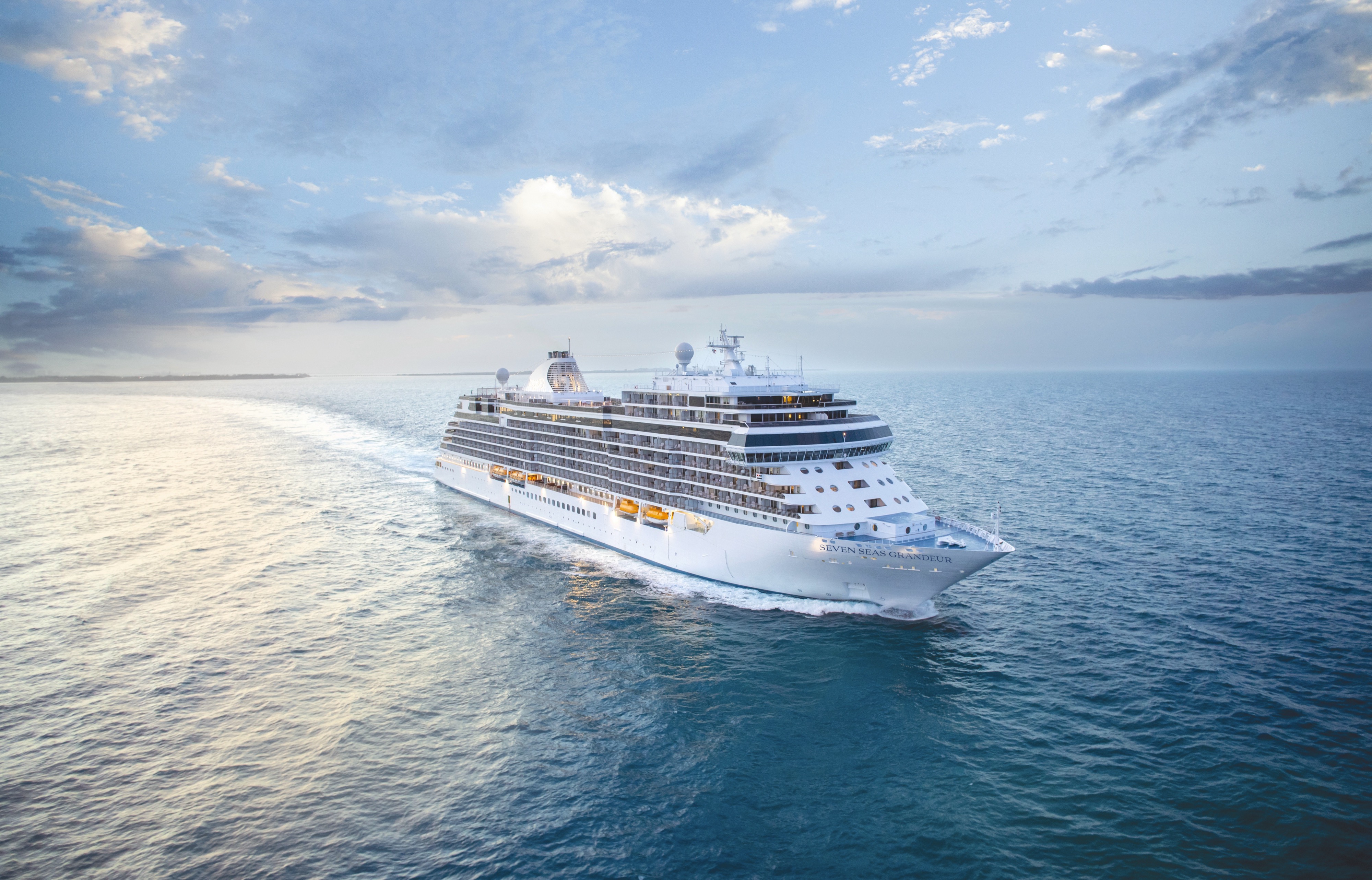
Seven Seas Grandeur
Inspired by the past and reimagined for the future, Seven Seas Grandeur® personifies our heritage of perfection.
Be enveloped by the incomparable comforts of Seven Seas Grandeur®, the ship that embodies our heritage of perfection. With unrivalled space, unparalleled service, exceptional cuisine, and transformative experiences abound, enjoy the new era of luxury cruising from the moment you step aboard.
Ship Facts
| Launch Year | 2023 | ||||
| Refit Year | |||||
| Language | en | ||||
| Gross Tonnage | 55500 | ||||
| Length | 224 | ||||
| Width | 31 | ||||
| Currency | USD | ||||
| Speed | 19 | ||||
| Capacity | 744 | ||||
| Crew Count | 548 | ||||
| Deck Count | 10 | ||||
| Cabin Count | 372 | ||||
| Large Cabin Count | N/A | ||||
| Wheelchair Cabin Count | N/A | ||||
| Electrical Plugs |
|
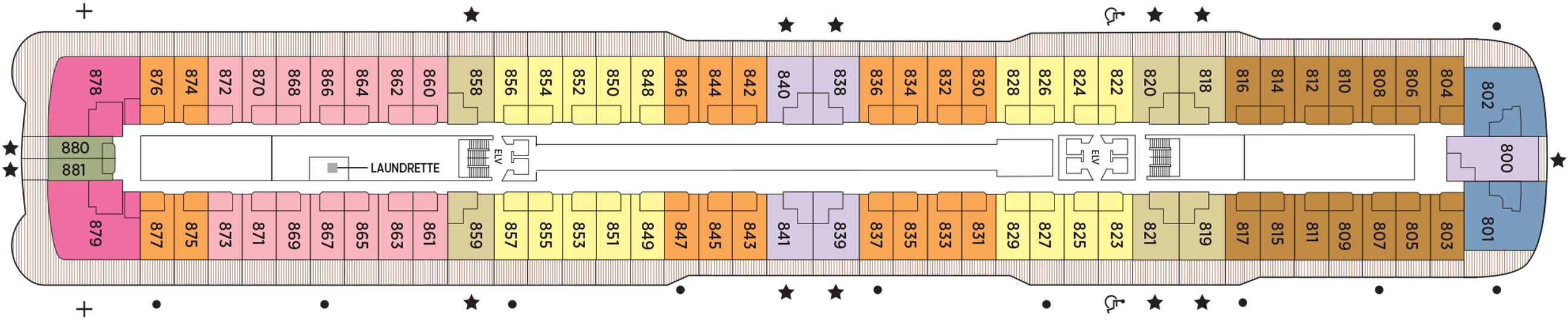
Deck 14
- Regent Suite
- Concierge Suites
- Penthouse Suites

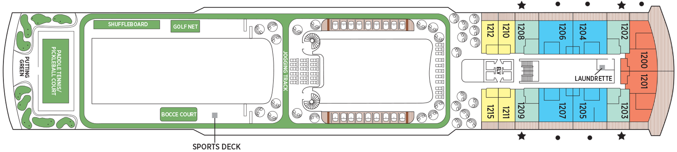
Deck 12
- Putting Green
- Shuffleboard
- Golf Net
- Bocce Court
- Paddle Tennis Court
- Sports Deck
- Jogging Track
- Concierge Suites
- Penthouse Suites
- Grandeur Suites
- Grand Suites
Deck 11
- La Veranda / Sette Mari
- La Veranda
- Pool Grill
- Infinity-Edge Plunge Pool
- Smoking Area
- Pool Bar
- Culinary Arts Kitchen
- Connoisseur Club
- Library
- Observation Lounge
- Card Room

Deck 10
- The Study
- Chartreuse
- Prime 7
- Bridge
- Concierge Suites
- Superior Suites
- Penthouse Suites
- Grand Suites
- Grandeur Suites

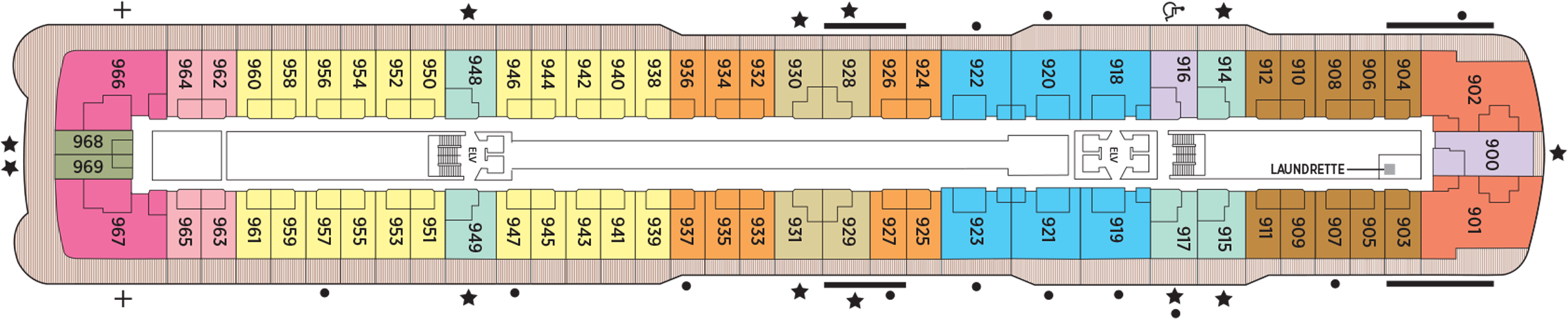
Deck 9
- Concierge Suites
- Penthouse Suites
- Grand Suites
- Grandeur Suites
- Serenity Suites
- Deluxe Veranda Suites
- Launderette
Deck 8
- Launderette
- Penthouse Suites
- Seven Sea Suites
- Signature Suites
- Seven Seas Suites
- Concierge Suites
- Serenity Suites
- Deluxe Veranda Suites
Deck 7
- Seven Seas Suites
- Penthouse Suites
- Serenity Suites
- Concierge Suites
- Veranda Suites
- Grand Suites
- Deluxe Veranda Suites
- Launderette
Deck 6
- Fitness Centre
- Penthouse Suites
- Concierge Suites
- Deluxe Veranda Suites
- Veranda Suites
- Launderette

Deck 5
- Atrium
- Coffee Connection
- Constellation Theatre
- Infinity-Edge Plunge Pool
- Meridian Lounge
- Pacific Rim
- Serene Spa & Wellness
- Business Center
- General Manager
- Destination Services
- Reception & Concierge
- Heated Jacuzzi

Deck 4
- Constellation Theatre
- Boutiques
- Atrium
- Grandeur Lounge
- The Casino
- Compass Rose

Each dish is prepared with care, showcasing superb quality and a presentation of complex flavors, textures and color combinations. The finest wines are deftly paired, having been hand-selected by our sommeliers.
Compass Rose
Our largest specialty restaurant on a ship full of spectacular dining options. Design your very own entrée from preferred sides, sauces, pastas and main features of beef, poultry and fish. Dessert? Decadent, of course.
We are pleased to re-introduce the elegantly enhanced Compass Rose, the largest specialty restaurant across our fleet. Ensuring a tantalizing mix of new and familiar items on every visit, the new lunch and dinner menus offer a vast selection to meet your discerning tastes. Exclusively aboard Seven Seas Mariner®, Seven Seas Voyager®, and Seven Seas Navigator® for lunch, you may choose from a robust list of appetizers and main courses from our specialty restaurants. And across our fleet for dinner, you have the unique ability to design your very own entrée from preferred sides, sauces, pastas and main features of beef, poultry and fish. This is in addition to sinfully indulgent desserts made by talented bakers and pastry chefs. With daily changing menus, the refreshed Compass Rose offers more choices than ever before.
Chartreuse
Classic French fare with a modern twist – and glorious ocean views. If Chartreuse seems familiar, you may have once stumbled upon a chic, fine-dining restaurant on a Champs-Elysees side street. A fantasy you can taste.
Chartreuse evokes memories of a chic Parisian fine dining restaurant discovered during an evening stroll. Wherever you are seated in this regal restaurant, you will be treated to a succulent dinner while enjoying incredible ocean views. The restaurant ambiance is complemented by a menu that features modern French dishes. Available on Seven Seas Grandeur™, Seven Seas Splendor®, Seven Seas Explorer®, Seven Seas Mariner® and Seven Seas Voyager® with reservations each evening for dinner, and open for lunch on Seven Seas Explorer on alternate port days. French bistro style food is offered.
Reservations Required
Prime 7
From perfectly aged New York strip, porterhouse and succulent filet mignon to smoked salmon with a phenomenal tamarind-whiskey sauce, Prime 7 elevates classic American fare to lofty heights.
A true classic in every sense, Prime 7 sets a new standard in steakhouse fare with its contemporary interpretation of an American classic. Handsomely decorated with supple leather wing-back chairs, burnished woods and rich earth-toned fabrics, Prime 7 exudes a distinct, intimate elegance. This is sophistication redefined, a luxurious setting to enjoy classic steakhouse cuisine with a modern flair.
All the traditional starters are here, including Jumbo Lump Crab Cakes, Classic Steak Tartare, and Clam Chowder. Of course, beef is the undisputed star, and it is aged for a minimum of 40 days to ensure the ultimate tenderness and juiciness. New York Strip, Porterhouse Steak and succulent Filet Mignon only touch upon the selections. Mouthwatering alternatives include Applewood Smoked Salmon and Dover Sole.
Reservations Required
Pacific Rim
Prepare to be delighted by a perfect balance of delicious flavors and Zen-like ambiance. Amid dimly lit architectural details and lotus-shaped windows, dine Pan-Asian creations like Korean barbecue lamb chops and wok-fried beans.
Coffee Connection
So much more than a great spot for coffee – this specially designed Coffee Connection is a chic metropolitan café with an ocean view that’s impossible to beat.
Sette Mari at la Veranda
Settle into cozy, over-water alcoves for classic Italian specialties made with care. From old-school classics to modern cuisine, your Sette Mari meal will linger long as a perfect combination of atmosphere and flavor.
Each evening, La Veranda transforms into Sette Mari at La Veranda, a casual, intimate dining experience. Enjoy an extensive menu of authentic antipasti and Italian specialties served á la carte and paired with fine Italian wines — complimentary of course. Delectable dishes are prepared á la minute by our talented chefs using only the freshest gourmet ingredients and served by our attentive waiters. Sette Mari at La Veranda is open for dinner only.
Pool Grill
Al fresco dining with views of the world’s best-loved landscapes. Be inspired by the environs around Seven Seas Grandeur™ while enjoying cuisines that include handcrafted pizzas, regional barbecues and old-fashioned desserts.
The Pool Grill is truly a come-as-you-are venue. Enjoy this casual dining experience whether you’re getting a bite after sunbathing or swimming in the pool. The Pool Grill is open-air, yet abundantly shaded for comfortable dining at lunch or dinner. Enjoy grilled-to-order burgers, grilled seafood, sandwiches, and fresh salads. Treat yourself to milkshakes and malts or an old-fashioned hand-dipped ice cream dessert with toppings.
La Veranda
Greet your days on the high seas with sumptuous breakfasts and shimmering ocean views. La Veranda features quiet alcoves, made-to-order omelets and, for late risers, tasty lunch buffets that include hot carving stations.
Take in stunning ocean views while enjoying elegant breakfast and lunch buffets in the chic indoor dining room or al fresco on the shaded, open-air deck. Breakfasts include traditional favorites, as well as a made-to-order omelet station, a variety of fresh fruits and pastries, along with daily specials, like fluffy Belgian waffles with fresh blueberry compote. For lunch indulge in an array of choices from a bountiful salad bar, gourmet sandwiches, hot carving stations and delicious desserts.
The Study
Hosting a maximum of twelve guests, discerning gourmands are met with the style and sophistication they would expect from an intimate epicurean experience aboard Regent Seven Seas Cruises®.
Room Service
Knowing that guests sometimes prefer to simply dine in the comfort of their suites, we offer room service around the clock. Select from an extensive room service menu and the wait staff will promptly serve your order in the comfort of your suite. During normal dining hours, guests may also order from the Compass Rose menu, which changes daily and features Continental, vegetarian, and kosher cuisines. Dinners will be graciously served course-by-course.
Daytime Enrichment
You'll find time spent on board the ship to be just as enriching as time ashore. Relax by the pool, compete in a friendly game of trivia or bocce ball, indulge in treats at afternoon tea and gain insight from an expert lecturer.
Evening Entertainment
Every evening on Seven Seas Grandeur will be one to remember. As the lights go on from the stage to the dance floor, this stunning vessel takes on a new life with live productions, high-caliber musicians, guest entertainers, intimate lounges and more.
Boutiques & More
Browse a well-curated selection of duty-free designer clothes, jewelry, perfume and more at the onboard boutiques. Then fuel up with an espresso from an onboard café or unwind at a wine tasting in one of the lounges.
Shows
From a dueling battle between genres and a story of romance to a thriller filled with intrigue, these are just a taste of the lavishly staged musical productions that await.
Pool Deck
The elegant Pool Deck on board Seven Seas Grandeur® is the ideal size for basking in the beauty of each day while sailing. Be it a dip in the refreshing pool or relaxing on a lounger with your favorite drink.
Grandeur Lounge
There’s no better way to whet your appetite for dinner than at this ship’s namesake lounge. Its elegant design will coax you into a state of relaxed bliss over signature cocktails and soulful sounds.
Pool Bar
Very few things equate to a pure vacation activity more than sitting at our Pool Bar. Make new friends while sipping a cocktail or frozen drink in the most laid-back atmosphere imaginable.
Meridian Lounge
With an expansive bar and relaxed armchairs, this is an ideal spot to gather with new friends for a cocktail, especially after an exciting theater performance that simply must be discussed at length.
Constellation Theater
Thrill to nightly performances in our glorious, two-deck-high theater. Plush seating and pleasing sightlines free you to focus on our lavishly staged, high-energy shows produced by our own team of Broadway professionals.
Observation Lounge
Every evening on Seven Seas Grandeur will be one to remember. As the lights go on from the stage to the dance floor, this stunning vessel takes on a new life with live productions, high-caliber musicians, guest entertainers, intimate lounges and more.
Boutiques
Browse a well-curated selection of duty-free designer clothes, jewelry, perfume and more at the onboard boutiques. Then fuel up with an espresso from an onboard café or unwind at a wine tasting in one of the lounges.
Atrium
Simply put, the Atrium is the very heart of Seven Seas Grandeur™. With a magnificent chandelier above, the grand staircase descends to Compass Rose, our signature restaurant, creating a grand entrance.
The Casino
Step into an intimate, sophisticated environment filled with fun and excitement. Challenge friends at the poker table, take on the house in a thrilling game of blackjack or sip a cocktail and watch the action unfold.
Business Centre
For those who’ve chosen to leave their laptops at home, desktop computers are available at our staffed Business Center. Of course, you may access WiFi without charge throughout the entirety of Seven Seas Grandeur™.
Destination Services
The place for you to arrange onshore activities, whether one of our INCLUDED Unlimited Shore Excursions or a unique, small-group Regent Choice Shore Excursion. All staff are eager to provide the assistance you need.
Card Room
Seeking friendly competition? This jovial room has a clubby charm that’s both inviting and tranquil. Gather some friends for board games or Bridge, or maybe a tournament.
Connoisseur Club
A very modern space with oversize leather armchairs and signature works of art, this guest favorite is more than its décor. You’ll immediately take to its low-key elegance, perhaps over a fine cigar and meaningful conversation.
Library
Step into our welcoming and well-stocked library for a relaxing respite. Browse volumes ranging from destination-specific guidebooks to best-selling mysteries and classic literature.
General Manager/Reception
While cruise-related issues are first submitted to Reception/Concierge, you can be assured that a General Manager is on hand to resolve issues to your satisfaction.
Our welcoming Reception Desk is open 24 hours a day and our staff is happy to answer your questions and provide any general assistance you may need.