
Tokyo to Whittier
Tokyo to Whittier
Cruise overview
WHY BOOK WITH US?
- ✔ The Deluxe Cruises’ team has extensive experience in ultra-luxury cruising.
- ✔ Call now to speak to our helpful and experienced Cruise Concierge team.
- ✔ Enjoy our Unique Deluxe Cruises Bonus for substantial savings.
- ✔ Our team will tailor your holiday to your exacting requirements.
- ✔ As agents, we work under the protection of each cruise lines ABTA / ATOL licences
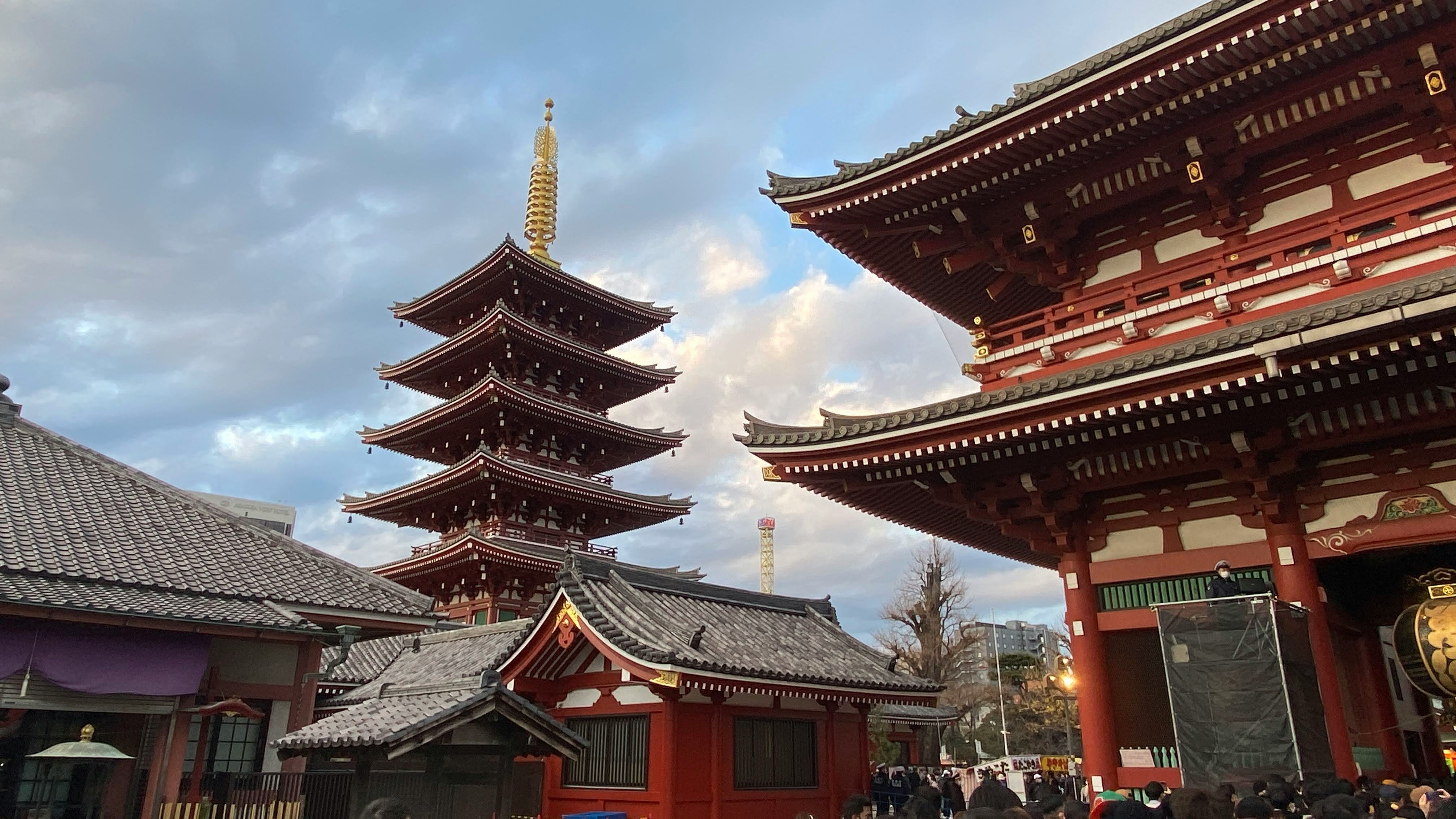
About Tokyo
Lights, sushi, manga! Sprawling, frenetic, and endlessly fascinating, Japan’s capital is a city of contrasts. Shrines and gardens are pockets of calm between famously crowded streets and soaring office buildings. Mom-and-pop noodle houses share street space with Western-style chain restaurants and exquisite fine dining. Shopping yields lovely folk arts as well as the newest electronics. And nightlife kicks off with karaoke or sake and continues with techno clubs and more. Whether you seek the traditional or the cutting edge, Tokyo will provide it.

About Aomori
Aomori's main event is its Nebuta Matsuri Festival,held August 2 to 7. People come to see illuminated floats of gigantic samurai figures paraded through the streets at night. Aomori's festival is one of Japan's largest, and is said to celebrate the euphoria of post-battle victory, and is thus encouraged to be noisier and livelier than you may have been exposed to in other Japanese festivals. Dancers, called heneto, run alongside the floats, dancing crazily, and you're encouraged to join in. Throughout the year you can enjoy delicious seafood from Aomori Bay, including Oma no Maguro (tuna of Oma), as well as delicious fruits and vegetables (particularly garlic). And come every summer, the town cuts loose to throw the decidedly wild Nebuta Matsuri festival, a frenzied, utterly unaccountable period when normal gets thrown to the wind.

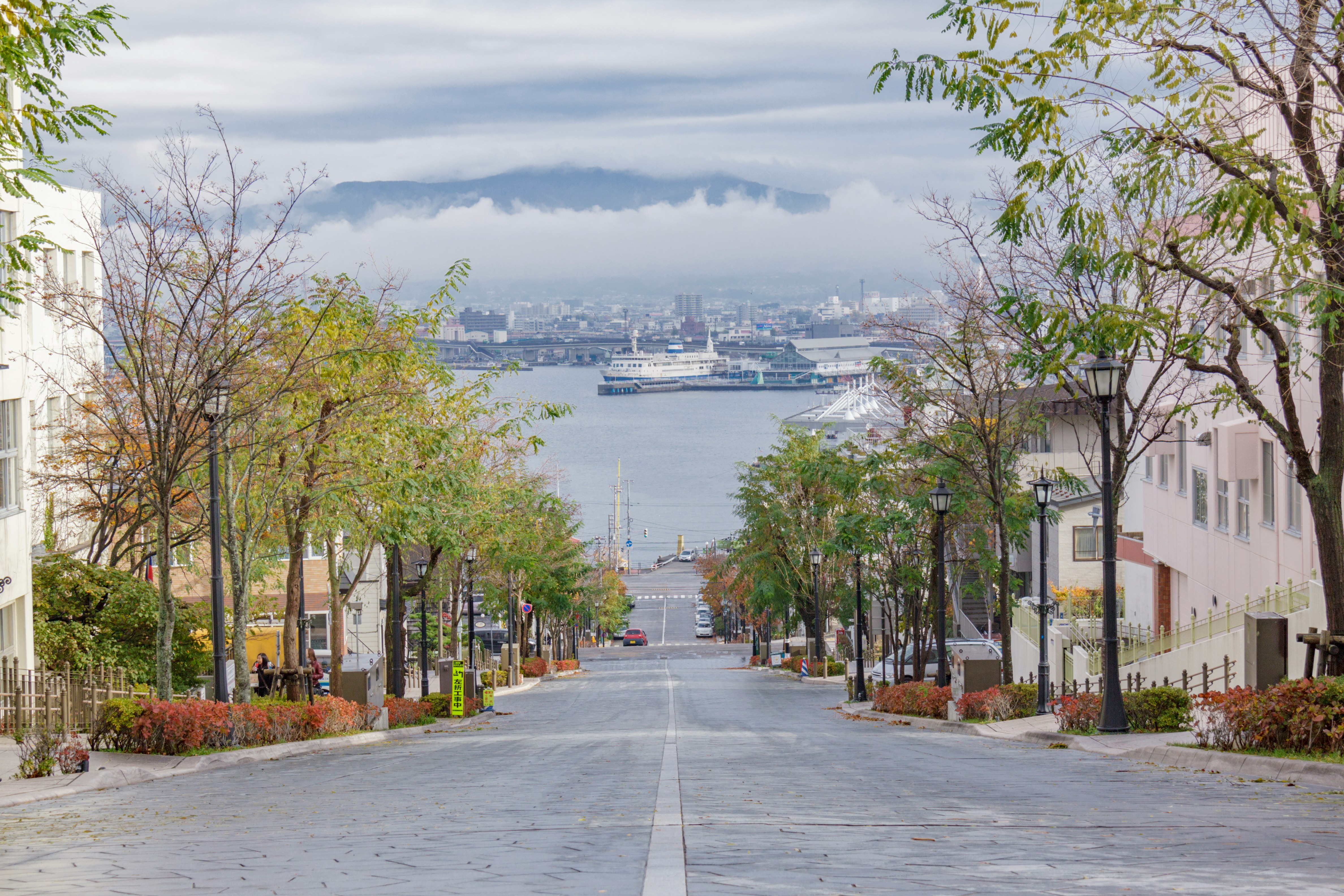
About Hakodate
Facing out on two bays, Hakodate is a 19th-century port town, with clapboard buildings on sloping streets, a dockside tourist zone, streetcars, and fresh fish on every menu. In the downtown historic quarter, a mountain rises 1,100 feet above the city on the southern point of the narrow peninsula. Russians, Americans, Chinese, and Europeans have all left their mark; this was one of the first three Japanese ports the Meiji government opened up to international trade in 1859. The main sights around the foot of Mt. Hakodate can be done in a day, but the city is best appreciated with an overnight stay for the illumination in the historic area, the night views from either the mountain or the fort tower, and the fish market at dawn. City transport is easy to navigate and English information is readily available. Evening departure trains from Tokyo arrive here at dawn—perfect for fish-market breakfasts.


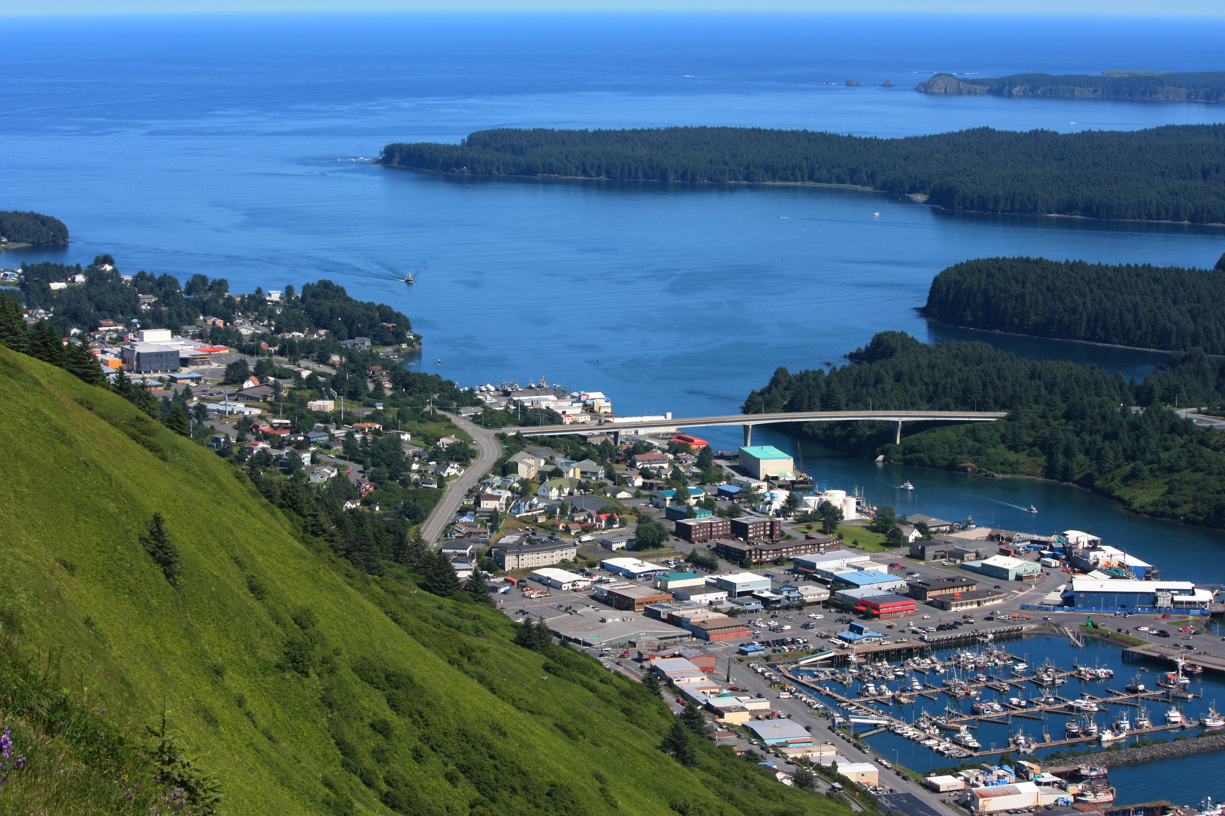
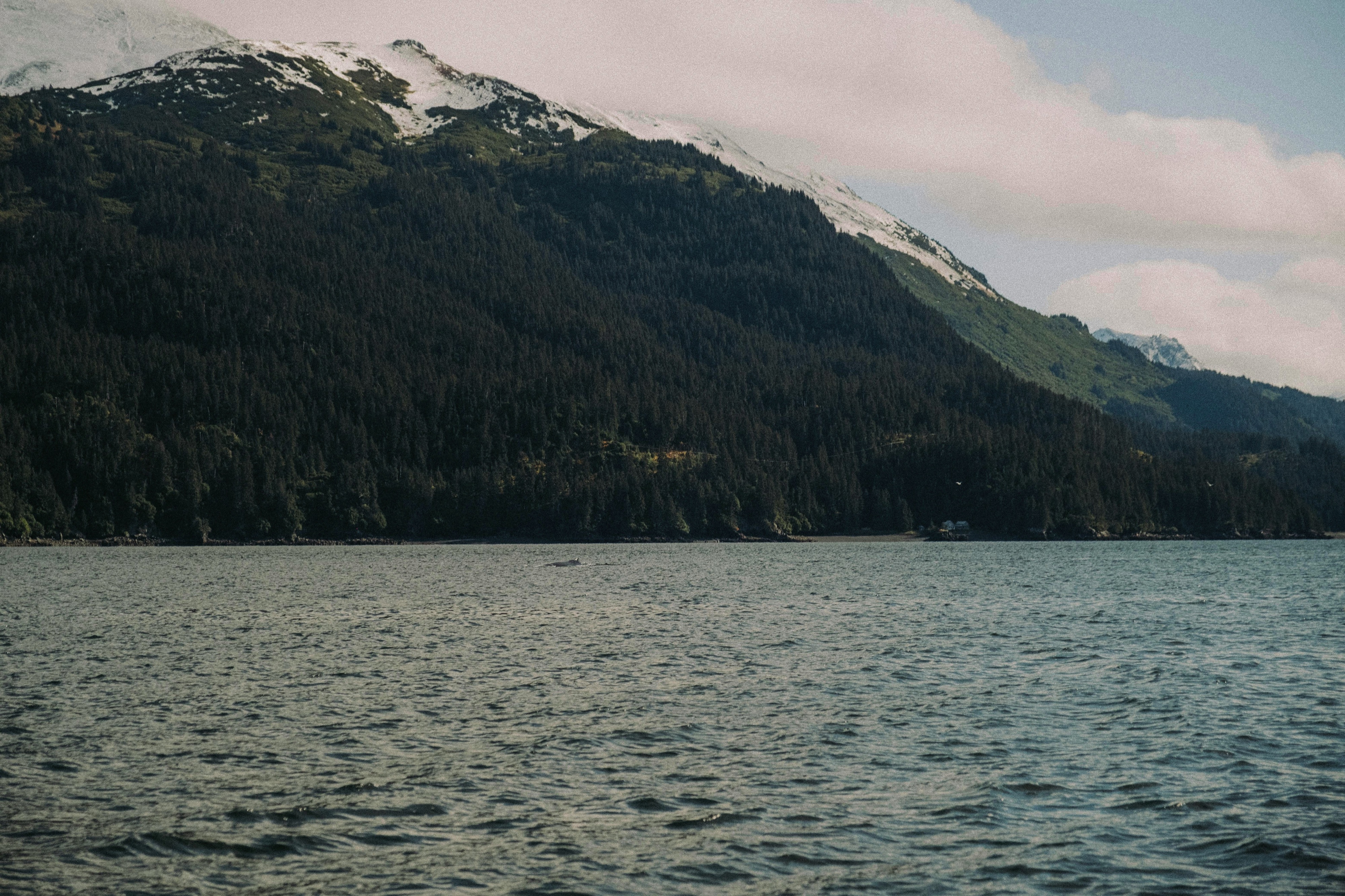
About Kodiak, Alaska
Today, commercial fishing is king in Kodiak. Despite its small population—about 6,475 people scattered among the several islands in the Kodiak group—the city is among the busiest fishing ports in the United States. The harbor is also an important supply point for small communities on the Aleutian Islands and the Alaska Peninsula.Visitors to the island tend to follow one of two agendas: either immediately fly out to a remote lodge for fishing, kayaking, or bear viewing; or stay in town and access whatever pursuits they can reach from the limited road system. If the former is too pricey an option, consider combining the two: drive the road system to see what can be seen inexpensively, then add a fly-out or charter-boat excursion to a remote lodge or wilderness access point.Floatplane and boat charters are available from Kodiak to many remote attractions, chief among them the Kodiak National Wildlife Refuge , which covers four islands in the Gulf of Alaska: Kodiak, Afognak, Ban, and Uganik.
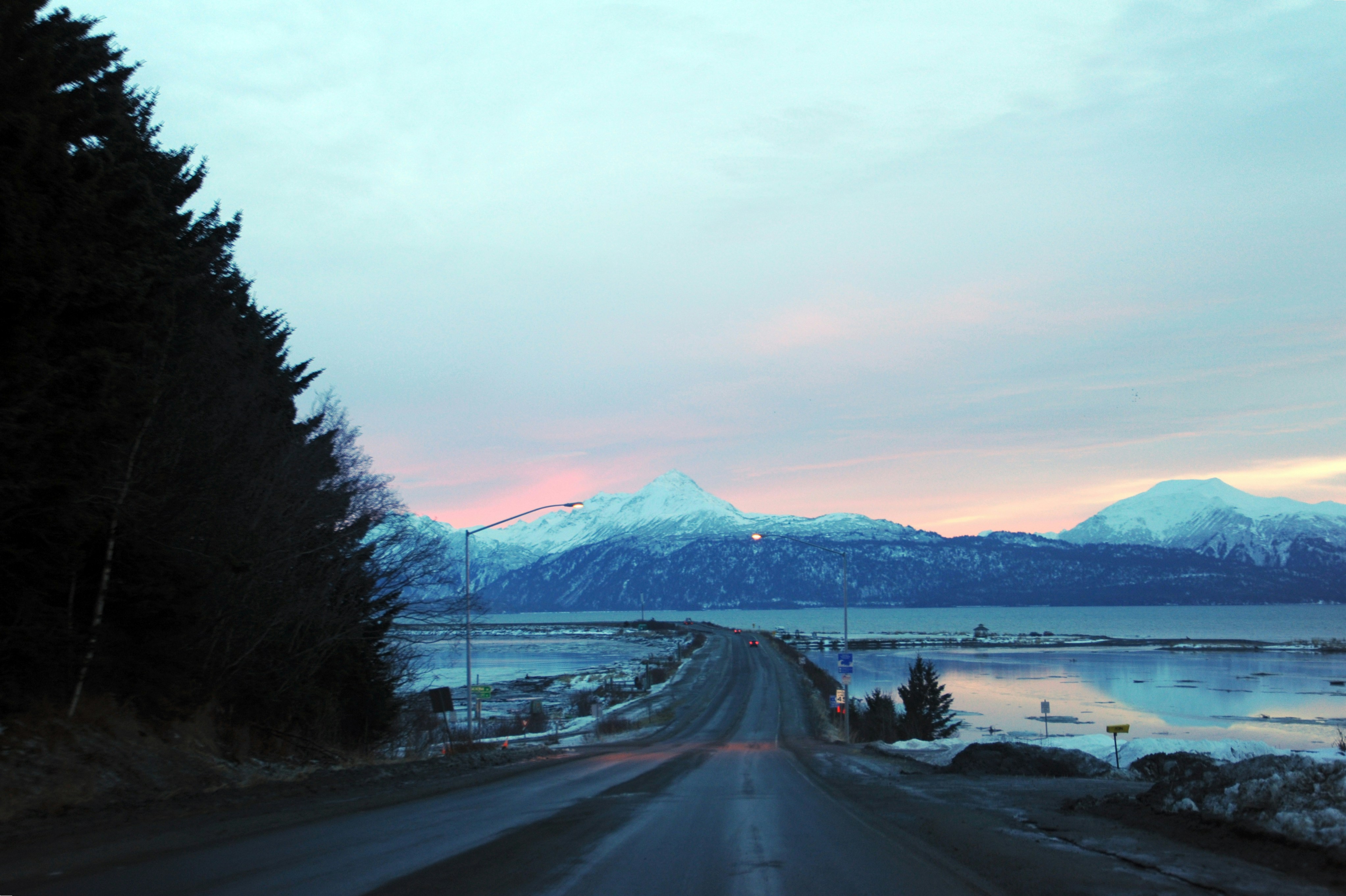
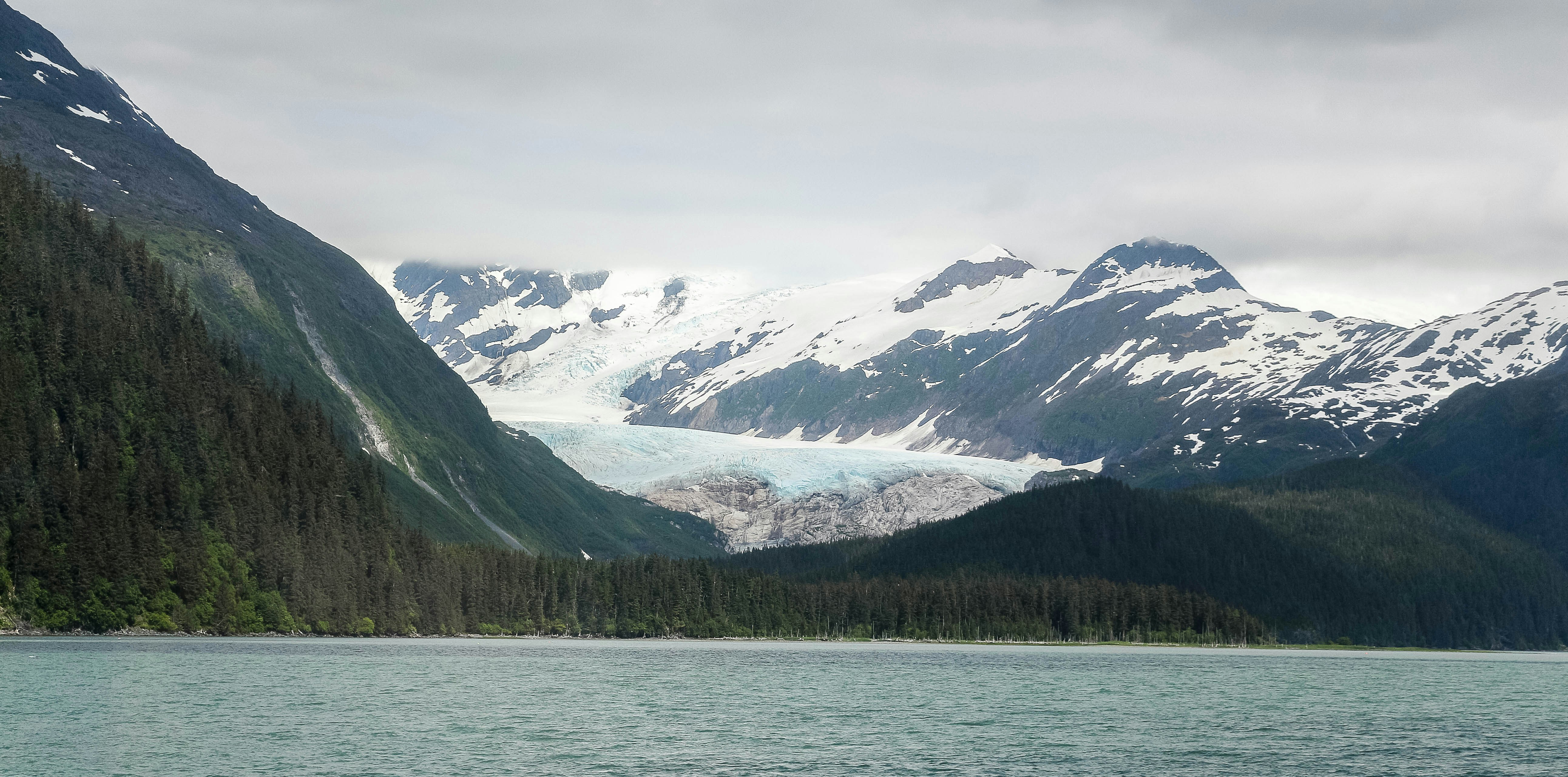
About Homer, Alaska
At the southern end of the Sterling Highway lies the city of Homer, at the base of a narrow spit that juts 4 miles into beautiful Kachemak Bay. Glaciers and snowcapped mountains form a dramatic backdrop across the water. Founded in the late 1800s as a gold-prospecting camp, this community was later used as coal-mining headquarters. Chunks of coal are still common along local beaches; they wash into the bay from nearby slopes where the coal seams are exposed. Today the town of Homer is an eclectic community with most of the tacky tourist paraphernalia relegated to the Spit (though do note the Spit has plenty else to recommend it, not the least of which is the 360-degree view of the surrounding mountains); the rest of the town is full of local merchants and artisans. The community is an interesting mix of fishermen, actors, artists, and writers. Much of the commercial fishing centers on halibut, and the popular Homer Jackpot Halibut Derby is often won by enormous fish weighing more than 300 pounds. The local architecture includes everything from dwellings that are little more than assemblages of driftwood to steel commercial buildings and magnificent homes on the hillside overlooking the surrounding bay, mountains, forests, and glaciers.
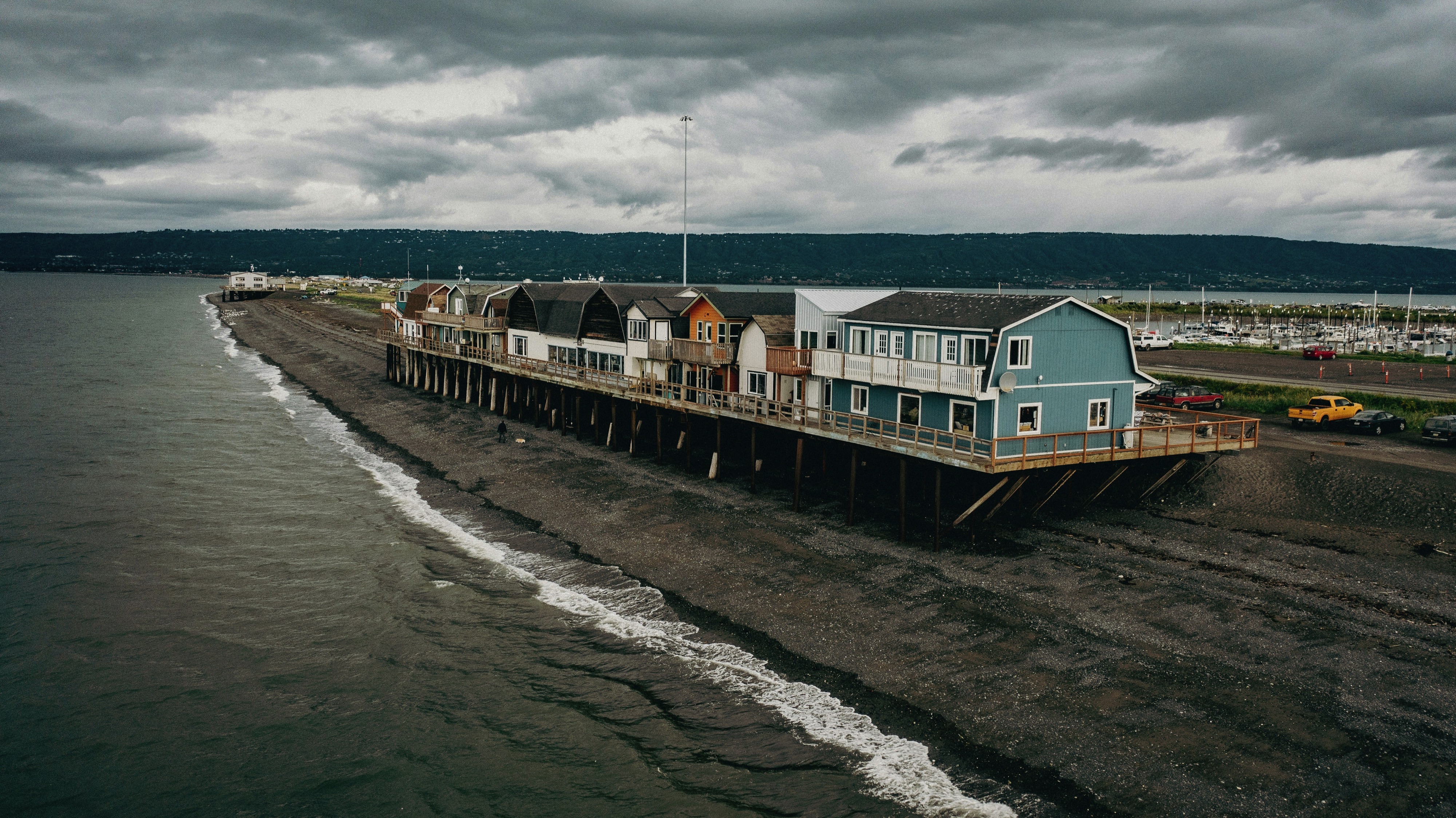
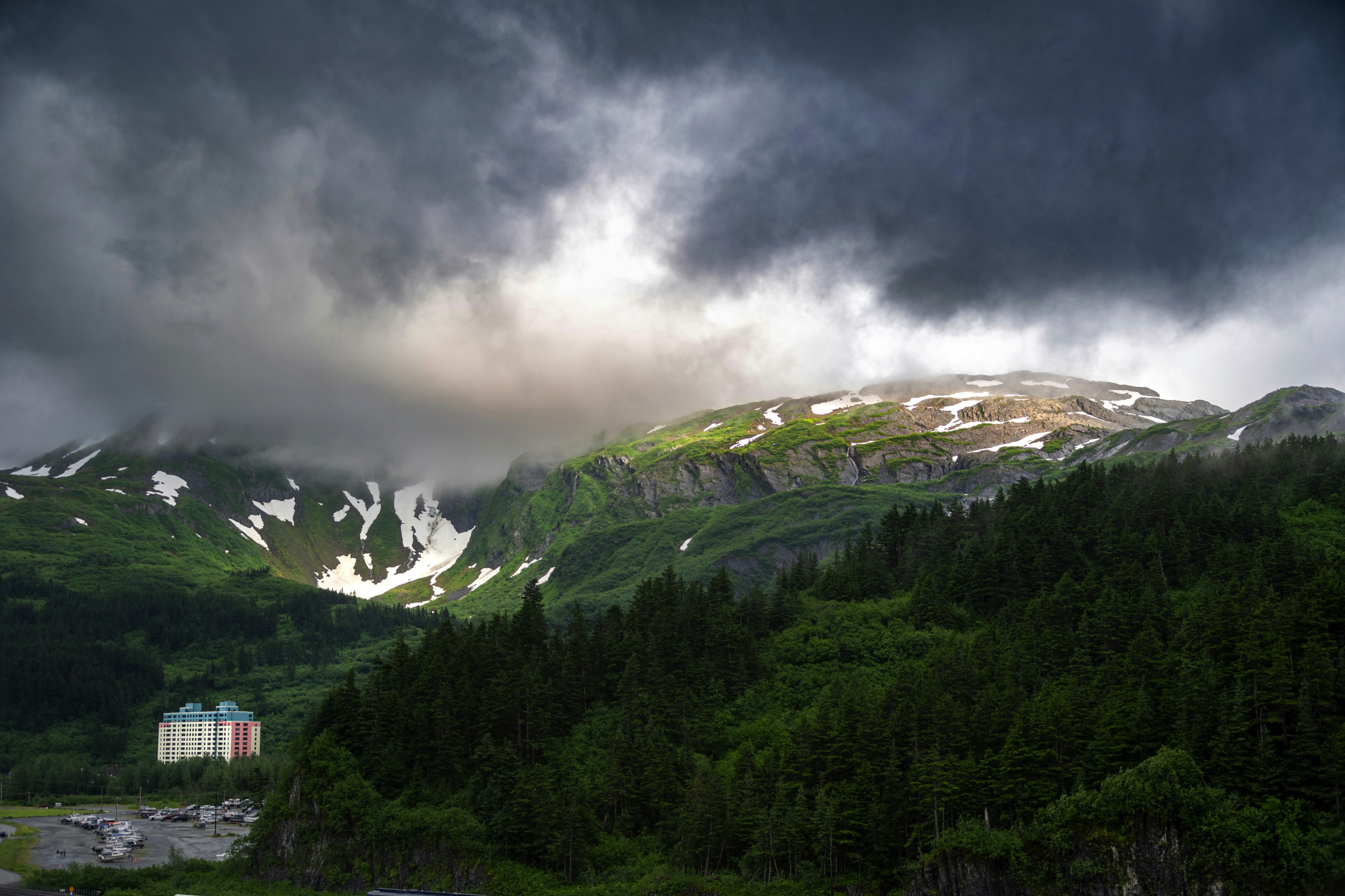
About Whittier
The tiny city of Whittier has just over 200 residents. It’s around 58 miles southeast of Anchorage in Alaska.


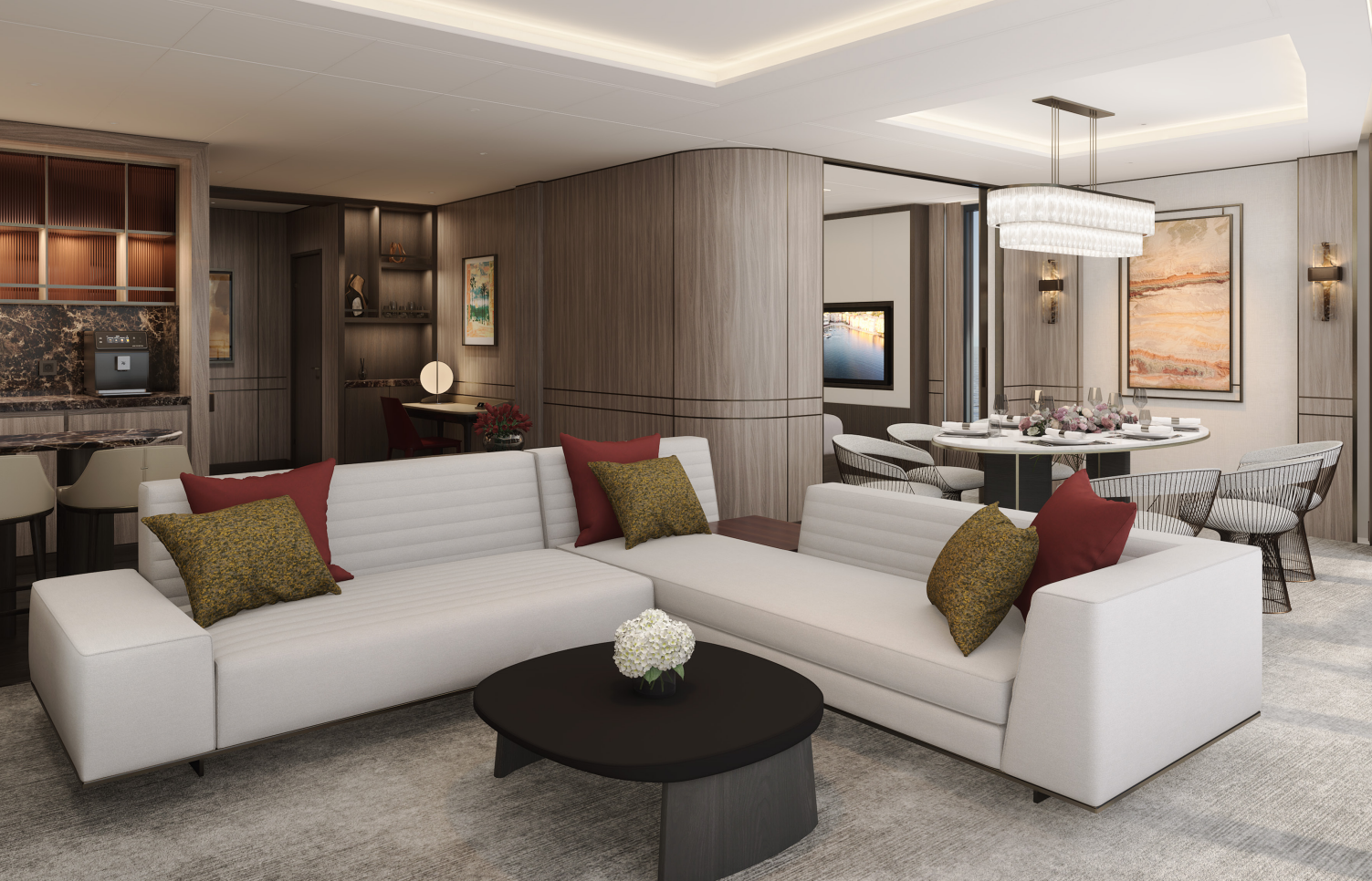
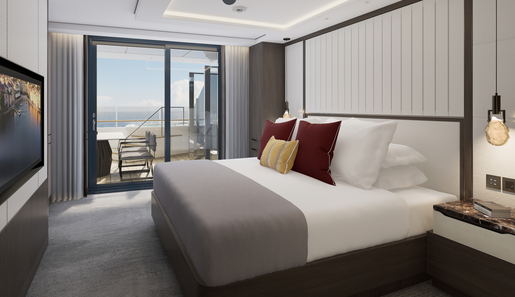
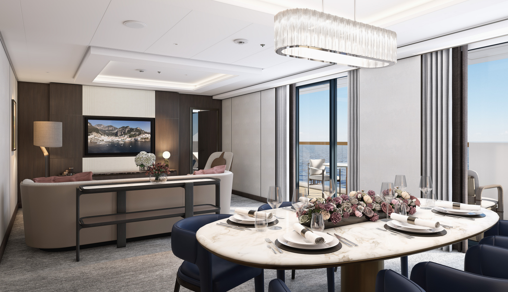
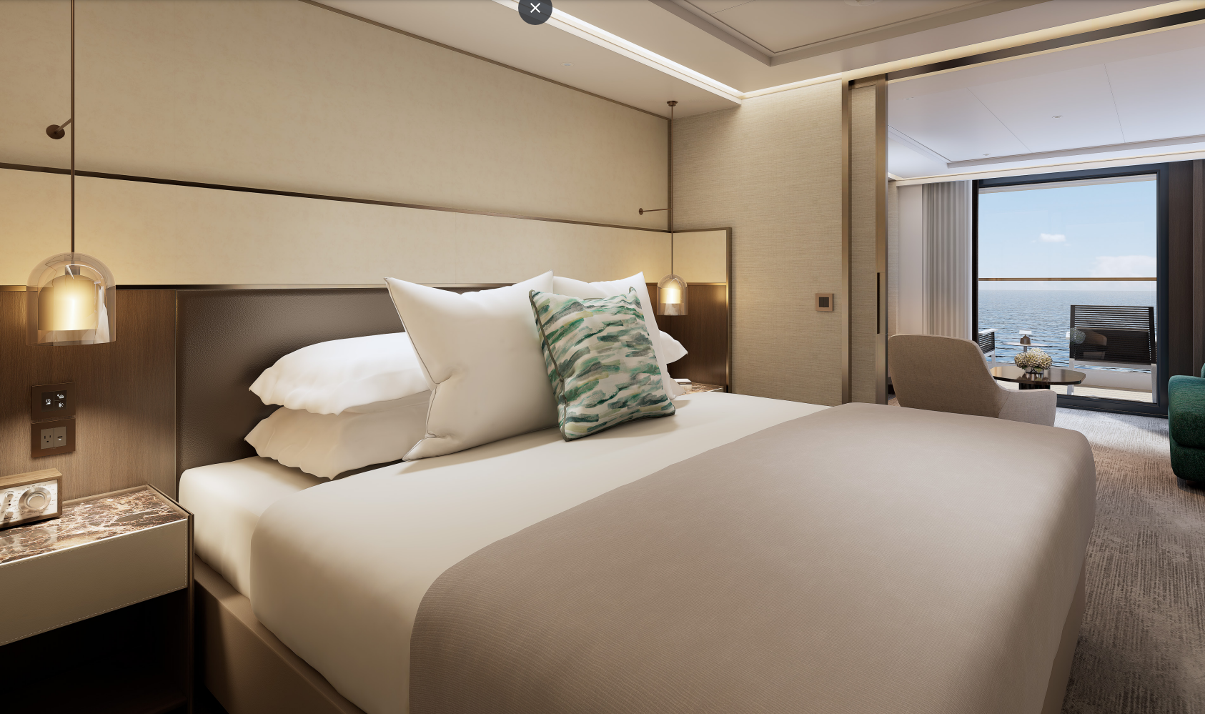
Natural light streams through the floor-to-ceiling windows of the Owner’s Suite, illuminating the interior of up to 1,033 square feet. The contemporary living area includes an in-suite bar for hosting cocktail hour before enjoying dinner with friends in the dining area — or alfresco on the expansive private terrace. After sunset, unwind under the stars in the terrace’s whirlpool spa and indulge in a soothing outdoor shower before heading inside to retire. The bedroom welcomes you to a sanctum of repose, complete with a custom king bed and spacious walk-in wardrobe, and the marble bath includes a modern shower, soaking tub, double vanity and in select suites, a powder room that can be accessed conveniently from the foyer.
OWNER SUITE
MAGNIFICENT OCEAN VIEWS
- Private, spacious terrace overlooking the ocean, with whirlpool and outdoor shower
SPACIOUS SUITE ACCOMMODATIONS
- Luxurious and modern living and dining area
- Luxury custom king bed sleep system
- Double vanity bathroom with modern soaking tub and separate shower
PERSONALIZED SERVICE AND AMENITIES
- 24-hour in-suite dining, espresso machine, complimentary coffee and teas and a minibar provisioned to your preferences, upon request once on board
ACCOMMODATIONS
Bed & Bath
- Luxury custom king bed sleep system
- Double vanity bathroom with modern soaking tub and separate shower
- Powder room with toilet and sink in select suites
- Custom luxury bed and bath linens
Suite Features
- Private, spacious terrace overlooking the ocean with whirlpool and outdoor shower
- Luxurious and modern living and dining area
- Walk-in wardrobe
- Convertible sleep sofa
Size
- Suite: 732 – 1033 SQ FT | 68 – 96 SQ M
- Terrace: 581 – 700 SQ FT | 54 – 65 SQ M
SERVICES AND AMENITIES
- 24-hour in-suite dining
- Luxury bath amenities and individual robe and slippers
- Premium Wi-Fi, supporting browsing, social media, streaming services, video calls and VPN services
- Complimentary chilled bottle of champagne upon arrival
- Espresso machine with complimentary coffee and teas
- Digital flat screen televisions
- In-suite safe
- Two vanity mirrors
- Two hair dryers
- Hypoallergenic pillows, upon request
- 230v and 120v outlets, as well as USB charging capabilities
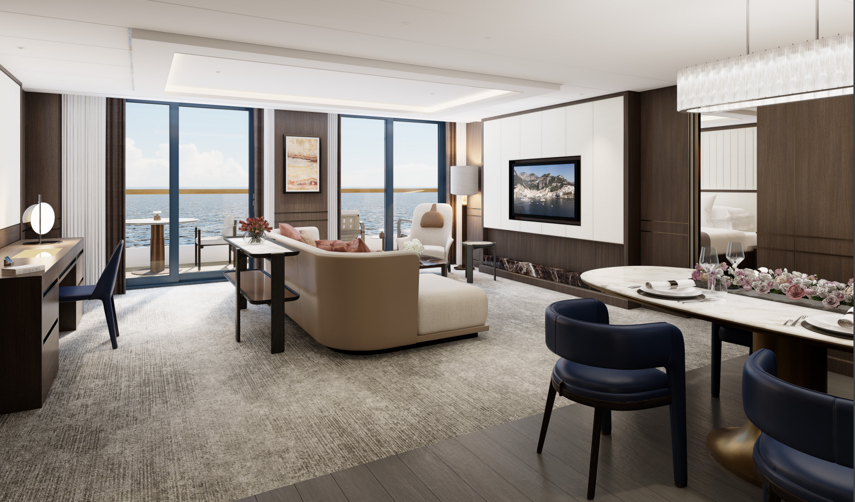
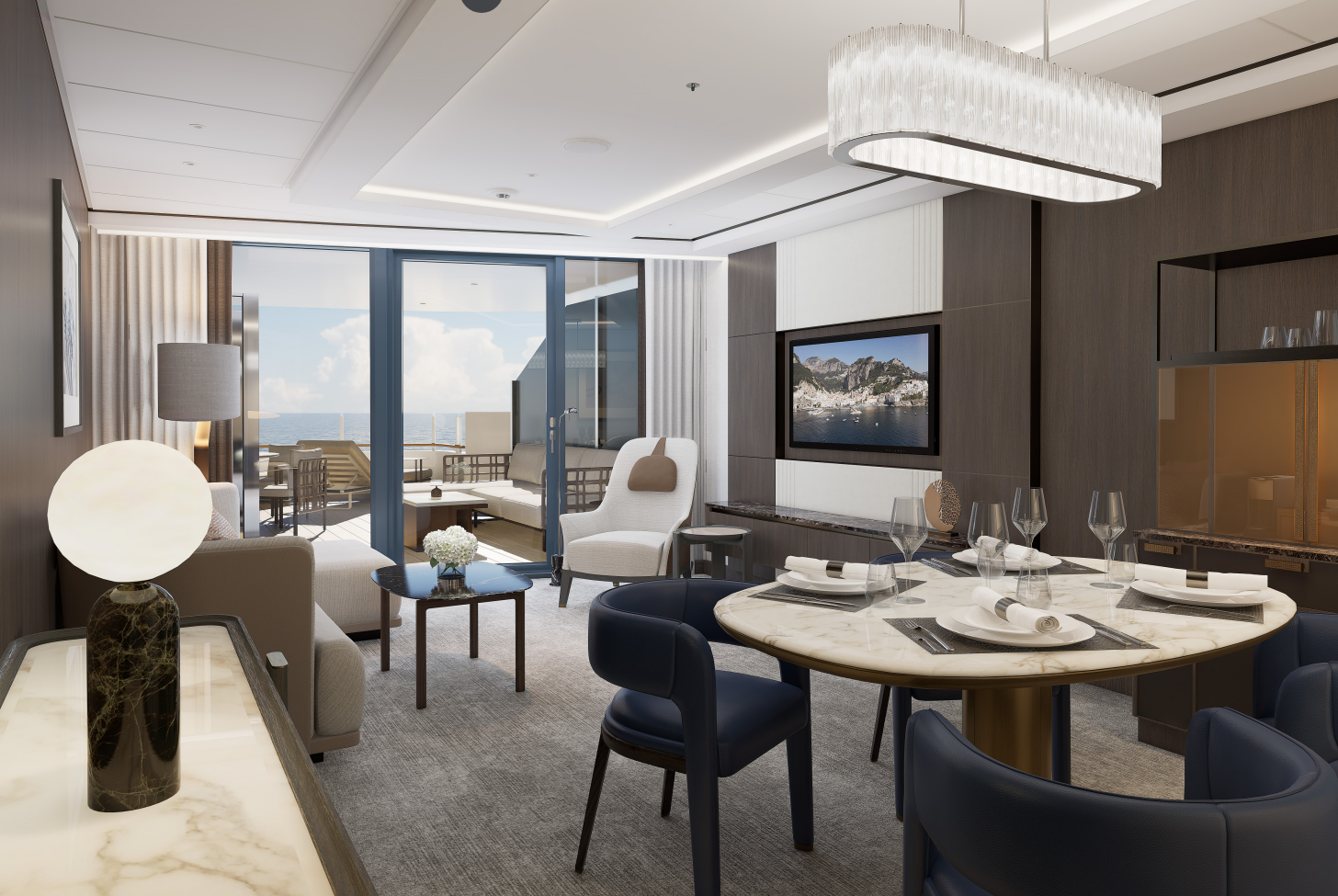
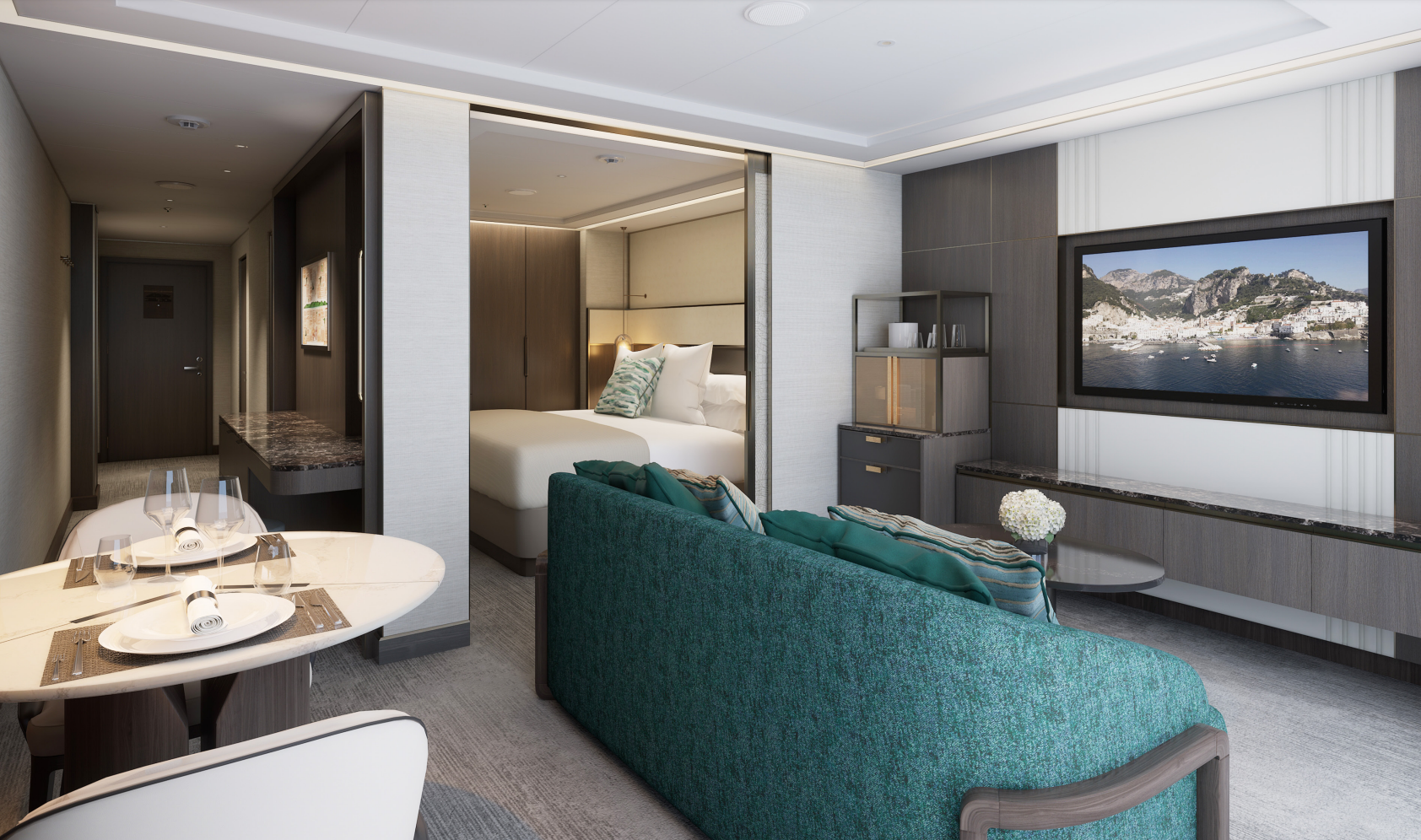
Spacious indoors and out, the Concierge Suite offers up to 786 square feet of interior area and a private terrace of up to 409 square feet. The bedroom includes a generous walk-in wardrobe and dressing area as well as a marble bath with a double vanity, walk-in shower, soaking tub and an enclosed powder room accessible from the foyer. Sunlight casts a warm glow through the floor-to-ceiling glass in the bedroom and living room, which both open onto the terrace so you can step out to take in the view, or enjoy an outdoor shower. The interior and outdoor spaces each feature an elegant dining area and a comfortable living area with a plush sofa, perfect for entertaining guests or enjoying a romantic evening for two.
CONCIERGE SUITE
MAGNIFICENT OCEAN VIEWS
- Private, spacious terrace overlooking the ocean, with outdoor shower and entry from living area and bedroom
SPACIOUS SUITE ACCOMMODATIONS
- Luxurious and modern living and dining area
- Luxury custom king bed sleep system
- Double vanity bathroom with modern soaking tub and separate shower
PERSONALIZED SERVICE AND AMENITIES
- 24-hour in-suite dining, espresso machine, complimentary coffee and teas and a minibar provisioned to your preferences, upon request once on board
ACCOMMODATIONS
Bed & Bath
- Luxury custom king bed sleep system
- Double vanity bathroom with modern soaking tub and separate shower
- Custom luxury bed and bath linens
Suite Features
- Private, spacious terrace overlooking the ocean with outdoor shower and entry from living area and bedroom
- Luxurious and modern living and dining area
- Walk-in wardrobe
- Convertible sleep sofa
Size
- Suite: 689 – 786 SQ FT | 64 – 73 SQ M
- Terrace: 355 – 409 SQ FT | 33 – 38 SQ M
SERVICES AND AMENITIES
- 24-hour in-suite dining
- Luxury bath amenities and individual robe and slippers
- Premium Wi-Fi, supporting browsing, social media, streaming services, video calls and VPN services
- Complimentary chilled bottle of champagne upon arrival
- Espresso machine with complimentary coffee and teas
- Digital flat screen televisions
- In-suite safe
- Two vanity mirrors
- Two hair dryers
- Hypoallergenic pillows, upon request
- 230v and 120v outlets, as well as USB charging capabilities
With spacious interiors of 883 square feet, the Residential Suite truly feels like a home upon the sea. The entire space brings the outdoors in through floor-to-ceiling glass that opens onto the 156-square-foot terrace from both the living room and bedroom. Invite friends to join you for dinner in the indoor dining area, or enjoy a romantic meal for just the two of you at the alfresco dining table. Within the private bedroom retreat, an ample walk-in wardrobe leads to the luxurious master bath with a soaking tub and shower, and the suite also features a separate powder room for guests.
RESIDENTIAL SUITE
MAGNIFICENT OCEAN VIEWS
- Private, spacious terrace overlooking the ocean, with entry from living area and bedroom
SPACIOUS SUITE ACCOMMODATIONS
- Luxurious and modern living and dining area
- Luxury custom king bed sleep system
- Double vanity bathroom with modern soaking tub and separate shower
PERSONALIZED SERVICE AND AMENITIES
- 24-hour in-suite dining, espresso machine, complimentary coffee and teas and a minibar provisioned to your preferences, upon request once on board
ACCOMMODATIONS
Bed & Bath
- Luxury custom king bed sleep system
- Double vanity bathroom with modern soaking tub and separate shower
- Custom luxury bed and bath linens
Suite Features
- Private, spacious terrace overlooking the ocean with entry from the living area and bedroom
- Luxurious and modern living and dining area
- Walk-in wardrobe
- Convertible sleep sofa
Size
- Suite: 883 SQ FT | 82 SQ M
- Terrace: 156 SQ FT | 14.5 SQ M
SERVICES AND AMENITIES
- 24-hour in-suite dining
- Luxury bath amenities and individual robe and slippers
- Premium Wi-Fi, supporting browsing, social media, streaming services, video calls and VPN services
- Complimentary chilled bottle of champagne upon arrival
- Espresso machine with complimentary coffee and teas
- Digital flat screen televisions
- In-suite safe
- Two vanity mirrors
- Two hair dryers
- Hypoallergenic pillows, upon request
- 230v and 120v outlets, as well as USB charging capabilities
The Luminara Suite embraces the ever-changing vistas along the horizon with an expansive private terrace of 291 to 301 square feet. Sunbathe with a traveling companion on the dual chaise lounges or curl up with a bestseller on the comfortable outdoor sofa. Host friends for dinner with a seaside harbor as a backdrop when you dine alfresco on the terrace or view the tableau through the floor-to-ceiling windows of the indoor dining area. Within up to 657 square feet of interior space, the cozy bedroom retreat features a luxurious king bed, spacious closets, and a modern shower system in the bath, which may also include a separate soaking tub.
LUMINARA SUITE
MAGNIFICENT OCEAN VIEWS
- Private, spacious terrace overlooking the ocean with outdoor shower
SPACIOUS SUITE ACCOMMODATIONS
- Luxurious and modern living and dining area
- Luxury custom king bed sleep system
- Double vanity bathroom with modern soaking tub and separate shower
PERSONALIZED SERVICE AND AMENITIES
- 24-hour in-suite dining, espresso machine, complimentary coffee and teas and a minibar provisioned to your preferences, upon request once on board
ACCOMMODATIONS
Bed & Bath
- Luxury custom king bed sleep system
- Double vanity bathroom with modern soaking tub and separate shower
- Custom luxury bed and bath linens
Suite Features
- Private, spacious terrace overlooking the ocean with outdoor shower
- Luxurious and modern living and dining area
- Walk-in wardrobe
- Convertible sleep sofa
Size
- Suite: 506 – 657 SQ FT | 47 – 61 SQ M
- Terrace: 291 – 301 SQ FT | 27 – 28 SQ M
SERVICES AND AMENITIES
- 24-hour in-suite dining
- Luxury bath amenities and individual robe and slippers
- Premium Wi-Fi, supporting browsing, social media, streaming services, video calls and VPN services
- Complimentary chilled bottle of champagne upon arrival
- Espresso machine with complimentary coffee and teas
- Digital flat screen television
- In-suite safe
- Two vanity mirrors
- Two hair dryers
- Hypoallergenic pillows, upon request
- 230v and 120v outlets, as well as USB charging capabilities
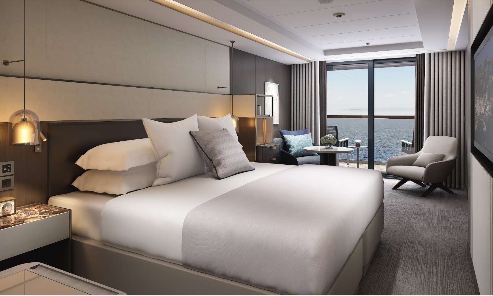
Within the View Suite interiors of up to 689 square feet, dramatic floor-to-ceiling windows in the living area and bedroom connect you to the surrounding seascapes. Step from the bedroom onto your private terrace of up to 205 square feet, where fresh sea breezes and scenic views await. After an alfresco breakfast, prepare for your day in the spacious marble bath featuring a double vanity, modern soaking tub and separate shower. The walk-in wardrobe and dressing area in the bedroom provide ample space to ready yourself for the day’s exploration. When evening comes, invite friends to join you in the dining area of your suite, which may also include a separate powder room for your guests.
VIEW SUITE
MAGNIFICENT OCEAN VIEWS
- Private terrace overlooking the ocean
SPACIOUS SUITE ACCOMMODATIONS
- Luxurious and modern living and dining area
- Luxury custom king bed sleep system
- Double vanity bathroom with modern soaking tub and separate shower
PERSONALIZED SERVICE AND AMENITIES
- 24-hour in-suite dining, espresso machine, complimentary coffee and teas and a minibar provisioned to your preferences, upon request once on board
ACCOMMODATIONS
Bed & Bath
- Luxury custom king bed sleep system
- Double vanity bathroom with modern soaking tub and separate shower
- Custom luxury bed and bath linens
- Powder room with toilet and sink in select suites
Suite Features
- Private terrace overlooking the ocean
- Luxurious and modern living and dining area
- Walk-in wardrobe
- Convertible sleep sofa
Size
- Suite: 517 – 689 SQ FT | 48 – 64 SQ M
- Terrace: 108 – 205 SQ FT | 10 – 19 SQ M
SERVICES AND AMENITIES
- 24-hour in-suite dining
- Luxury bath amenities and individual robe and slippers
- Premium Wi-Fi, supporting browsing, social media, streaming services, video calls and VPN services
- Complimentary chilled bottle of champagne upon arrival
- Espresso machine with complimentary coffee and teas
- Digital flat screen televisions
- In-suite safe
- Two vanity mirrors
- Two hair dryers
- Hypoallergenic pillows, upon request
- 230v and 120v outlets, as well as USB charging capabilities
With 560 square feet of interior luxury plus a private terrace of up to 199 square feet, the Grand Suite has all the comforts of home and then some. Host friends for dinner at the stylish dining table for four and enjoy after-dinner drinks and conversation in the spacious living area. When it’s time to retire, open the double doors onto your bedroom retreat, which includes dual walk-in wardrobes, and enjoy a relaxing soak in the marble-clad tub before drifting off in the comfort of the custom king bed. Each morning, sip an espresso on your terrace as you take in the view of the enchanting destination you’re about to explore.
GRAND SUITE
MAGNIFICENT OCEAN VIEWS
- Private terrace overlooking the ocean
SPACIOUS SUITE ACCOMMODATIONS
- Luxurious and modern living and dining area
- Luxury custom king bed sleep system
- Double vanity bathroom with modern soaking tub and separate shower
PERSONALIZED SERVICE AND AMENITIES
- 24-hour in-suite dining, espresso machine, complimentary coffee and teas and a minibar provisioned to your preferences, upon request once on board
ACCOMMODATIONS
Bed & Bath
- Luxury custom king bed sleep system
- Double vanity bathroom with modern soaking tub and separate shower
- Custom luxury bed and bath linens
Suite Features
- Private terrace overlooking the ocean
- Luxurious and modern living and dining area
- Dual walk-in wardrobe
- Convertible sleep sofa
Size
- Suite: 560 SQ FT | 52 SQ M
- Terrace*: 90 – 199 SQ FT | 8.4 – 18.5 SQ M
- *Expanded terrace on Deck 6
SERVICES AND AMENITIES
- 24-hour in-suite dining
- Luxury bath amenities & individual robe and slippers
- Premium Wi-Fi, supporting browsing, social media, streaming services, video calls and VPN services
- Complimentary chilled bottle of champagne upon arrival
- Espresso machine with complimentary coffee and teas
- Digital flat screen televisions
- In-suite safe
- Two vanity mirrors
- Two hair dryers
- Hypoallergenic pillows, upon request
- 230v and 120v outlets, as well as USB charging capabilities
The welcoming entry corridor of the Signature Suite leads to an intimate dining area for two, where you can enjoy a delicious meal at any time of day or night. Then take in a movie from the plush sofa in the living area, or from the custom king bed in the spacious bedroom that features a second television. The bath offers the convenience of a double vanity for couples, a walk-in shower and a soaking tub, perfect for unwinding after adventures ashore. The ample 409 square feet of interior space is complemented by a private outdoor terrace of up to 151 square feet, where a comfortable lounger is equally suited to sunbathing or stargazing.
SIGNATURE SUITE
MAGNIFICENT OCEAN VIEWS
- Private terrace overlooking the ocean
SPACIOUS SUITE ACCOMMODATIONS
- Luxurious and modern living and dining area
- Luxury custom king bed sleep system
- Double vanity bathroom with modern soaking tub and separate shower
PERSONALIZED SERVICE AND AMENITIES
- 24-hour in-suite dining, espresso machine, complimentary coffee and teas and a minibar provisioned to your preferences, upon request once on board
ACCOMMODATIONS
Bed & Bath
- Luxury custom king bed sleep system
- Double vanity bathroom with modern soaking tub and separate shower
- Custom luxury bed and bath linens
Suite Features
- Private terrace overlooking the ocean
- Luxurious and modern living and dining area
- Convertible sleep sofa in select suites
Size
- Suite: 409 SQ FT | 38 SQ M
- Terrace*: 71 – 151 SQ FT | 6.6 – 14 SQ M
- *Expanded terrace on Deck 6
SERVICES AND AMENITIES
- 24-hour in-suite dining
- Luxury bath amenities and individual robe and slippers
- Premium Wi-Fi, supporting browsing, social media, streaming services, video calls and VPN services
- Complimentary chilled bottle of champagne upon arrival
- Espresso machine with complimentary coffee and teas
- Digital flat screen televisions
- In-suite safe
- Two vanity mirrors
- Two hair dryers
- Hypoallergenic pillows, upon request
- 230v and 120v outlets, as well as USB charging capabilities
The airy interiors of the Terrace Suite offer 294 square feet of comfort, and just beyond the floor-to-ceiling windows, the namesake private terrace provides up to 108 square feet overlooking the sea. This personal oasis includes a custom king bed, an ample wardrobe and a separate sitting area for curling up with a good book. The marble bath features luxurious amenities by Diptyque Paris, a modern shower system and a double vanity — ideal when sharing the space with a companion. Wake each morning to fresh coffee from the in-suite espresso machine and conclude each day with a nightcap from the mini-bar, while a Suite Ambassador attends to your wishes in the moments in between.
TERRACE SUITE
MAGNIFICENT OCEAN VIEWS
- Private terrace overlooking the ocean
SPACIOUS SUITE ACCOMMODATIONS
- Luxury custom king bed sleep system
- Double vanity bathroom with modern shower system
PERSONALIZED SERVICE AND AMENITIES
- 24-hour in-suite dining, espresso machine, complimentary coffee and teas and a minibar provisioned to your preferences, upon request once on board
ACCOMMODATIONS
Bed & Bath
- Luxury custom king bed sleep system
- Double vanity bathroom with modern shower system
- Custom luxury bed and bath linens
Suite Features
- Private terrace overlooking the ocean
Size
- Suite: 294 SQ FT | 27.3 SQ M
- Terrace*: 52 – 108 SQ FT| 4.8 – 10 SQ M
- ADA
- Suite: 452 SQ FT | 42 SQ M
- Terrace*: 73 – 161 SQ FT | 6.8 – 15 SQ M
- *Expanded terrace on Decks 5 and 6
SERVICES AND AMENITIES
- 24-hour in-suite dining
- Luxury bath amenities and individual robe and slippers
- Premium Wi-Fi, supporting browsing, social media, streaming services, video calls and VPN services
- Complimentary chilled bottle of champagne upon arrival
- Espresso machine with complimentary coffee and teas
- Digital flat screen television
- In-suite safe
- Two vanity mirrors
- Two hair dryers
- Hypoallergenic pillows, upon request
- 230v and 120v outlets, as well as USB charging capabilities
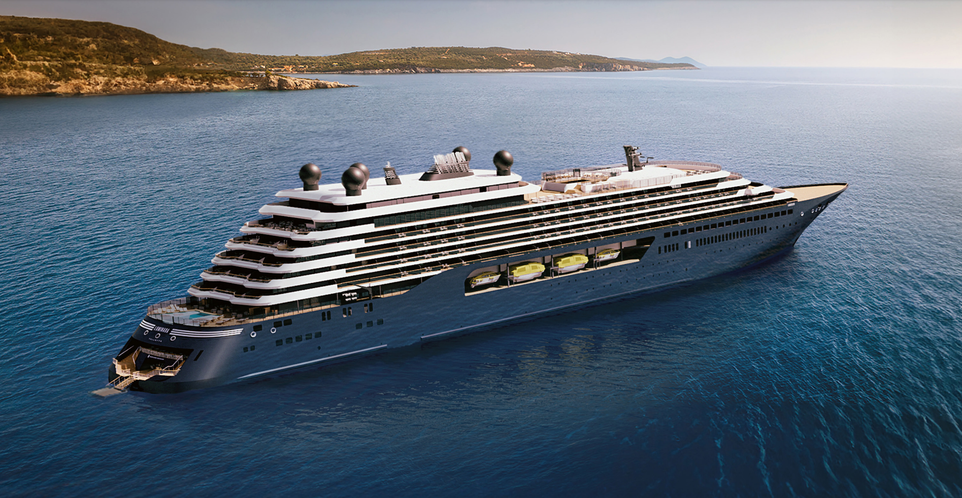
Luminara
A beacon of modern elegance inspired by light’s allure embarks on inaugural Mediterranean voyages in 2025. Luminara, our next superyacht, features 226 suites with private terraces and unparalleled space ratios for guests at sea, while two new upper suite categories deliver 1,000 square feet of uplifting ambiance. Savor moments in five restaurants, six bars, and a wine vault. The expanded marina makes the sea your playground, and The Ritz-Carlton Spa® your haven for transformation.
Ship Facts
| Launch Year | 2025 | ||||||||||
| Refit Year | |||||||||||
| Language | en | ||||||||||
| Gross Tonnage | 46750 | ||||||||||
| Length | 241 | ||||||||||
| Width | 29 | ||||||||||
| Currency | USD | ||||||||||
| Speed | 18 | ||||||||||
| Capacity | 452 | ||||||||||
| Crew Count | 374 | ||||||||||
| Deck Count | 8 | ||||||||||
| Cabin Count | 226 | ||||||||||
| Large Cabin Count | N/A | ||||||||||
| Wheelchair Cabin Count | N/A | ||||||||||
| Electrical Plugs |
|
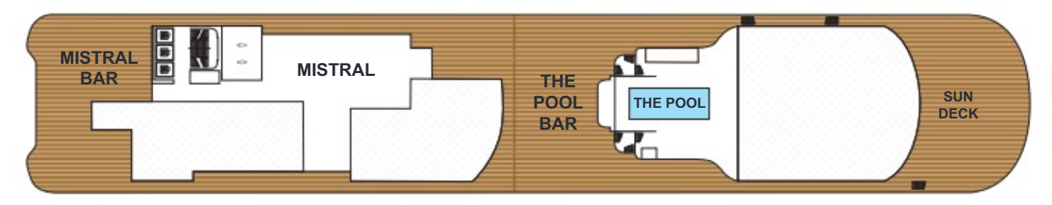
Deck 10
- Mistral
- Mistral Bar
- The Pool
- The Pool Bar
- Sun Deck
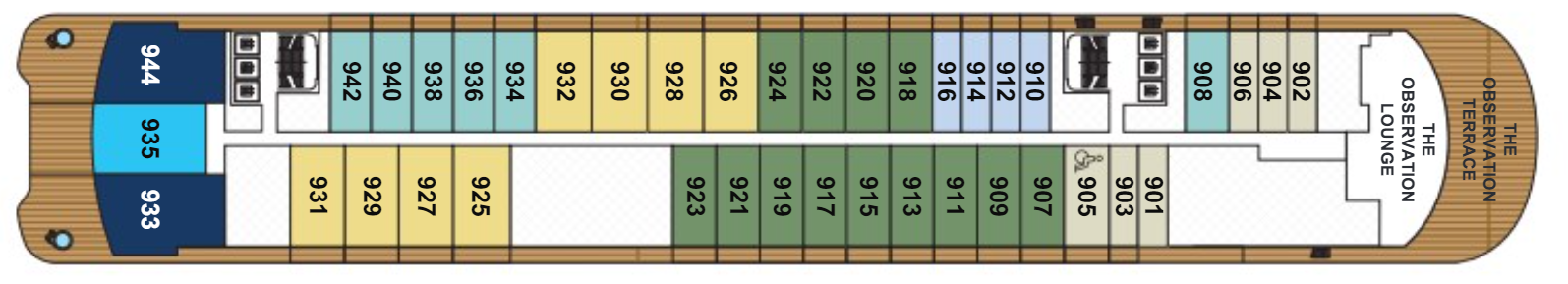
Deck 9
- The Observation Lounge & Terrace
- The Owner's Suite
- The Concierge Suite
- The Grand Suite
- The Signature Mid Suite
- The Signature Suite
- The Terrace Mid Suite
- The Terrace Suite
Deck 8
- The Owners Suite
- The Concierge Suite
- The Grand Suite
- The Signature Mid Suite
- The Signature Suite
- The Terrace Mid Suites
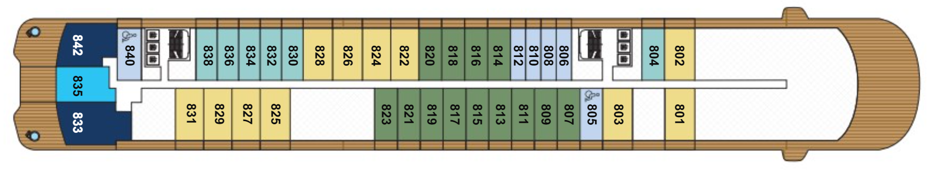
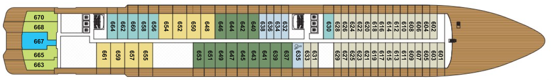
Deck 7
- The Owner's Suite
- The Concierge Suite
- The Residential Suite
- The View Suites
- The Grand Suites
- The Signature Mid Suites
- The Signature Suites
- The Terrace Mid Suites
- The Terrace Suites

Deck 6
- The Concierge Suite
- The Luminara Suite
- The Grand Suite
- The Signature Mid Suite
- The Signature Suite
- The Terrace Mid Suite
- The Terrace Suite
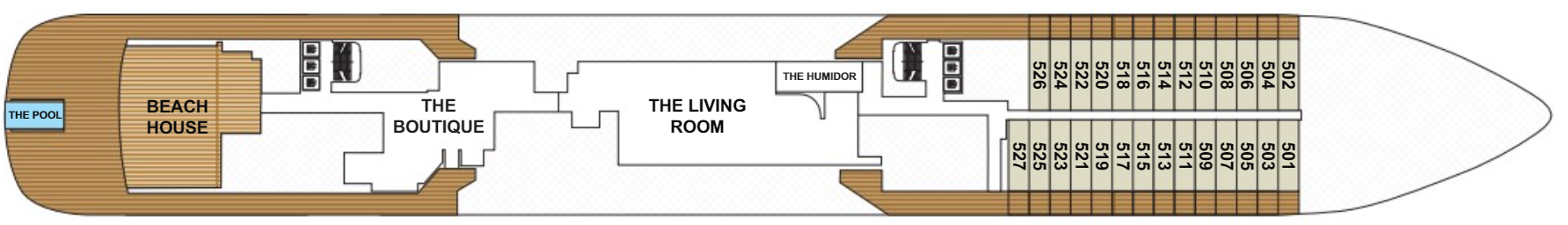
Deck 5
- The Living Room
- Beach House
- Infinity Pool
- The Humidor
- The Boutique
- Terrace Suites
- The Pool
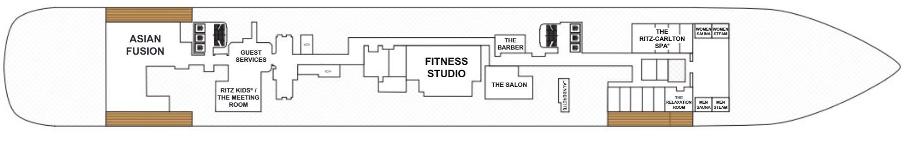
Deck 4
- The Ritz Carlton Spa
- Asian Fusion
- The Fitness Studio
- Ritz Kids® / The Meeting Room
- Women Steam and Sauna
- Men Steam and Sauna
- The Relaxation Room
- Launderette
- The Barber
- The Salon
- Guest Services
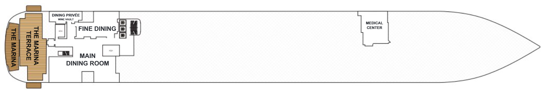
Deck 3
- The Marina Terrace
- The Marina
- Main Dining Room
- Fine Dining
- Dining Privee
- Wine Vault
- Medical Centre
Tempt your palate with unique dining experiences that combine fresh ingredients with the skill and expertise of highly trained chefs. Indulge in an à la carte dining experience designed by Chef Sven Elverfeld of Aqua, the three Michelin-starred restaurant at The Ritz-Carlton®, Wolfsburg, enjoy a fresh catch al fresco as you bask poolside, or order in-suite dining whenever the mood strikes. Our culinary program ensures your every craving can be fulfilled.
Main Dining Room
Spacious yet intimate, the main restaurant features an ever-changing menu of dishes inspired by the diverse regions that Luminara explores.
Fine Dining
Elegant and modern in design, the specialty dining experience offers decadent tasting menus featuring exquisite cuisine deeply rooted in Italian traditions.
Dining Privee
Join friends at a private enclave within Tides for an exclusive dining experience, the perfect setting for celebratory dinners and other special events.
Asian Fusion
Have a seat at the sushi bar or grab a table indoors or alfresco to savor creative interpretations of Southeast Asian cuisine.
Beach House
Dine indoors or alfresco on Latin-inspired cuisine, complemented by craft beers, bold wines and an elevated tequila selection, in this elegant yet relaxed space evoking a chic beach club.
Mistral
Just steps from the Main Pool, Mistral invites you to a celebration of timeless Mediterranean cuisine.
The Living Room
This comfortable gathering place with a library transforms from a coffee bar to a cocktail lounge with live music at night and serves ready-made treats throughout the day.
The Boutique
Designer apparel, jewelry and leather goods entice shoppers, as do the collaborations with local artisans showcasing their work in select ports.
The Observation Lounge & Terrace
Panoramic views of the sea and shore provide the perfect backdrop for relaxing, socializing and sunbathing.
The Humidor
Sip a fine cognac and enjoy an exceptional selection of hand-rolled cigars showcased in a state-of-the-art humidor.
Marina Terrace
Enjoy drinks and light bites with views of the sea on a spacious terrace just steps above the Marina.
The Main Pool & Pool Bar
Relax on a comfortable chaise, sun yourself on the pool’s tanning ledge, or cool off with a dip in the water at The Pool Deck, an inviting space at any time of day.