Highlights of Antarctica, Argentina and Brazil - Cruise & Land Journey
Highlights of Antarctica, Argentina and Brazil - Cruise & Land Journey
Cruise overview
WHY BOOK WITH US?
- ✔ The Deluxe Cruises’ team has extensive experience in ultra-luxury cruising.
- ✔ Call now to speak to our helpful and experienced Cruise Concierge team.
- ✔ Enjoy our Unique Deluxe Cruises Bonus for substantial savings.
- ✔ Our team will tailor your holiday to your exacting requirements.
- ✔ As agents, we work under the protection of each cruise lines ABTA / ATOL licences
About Rio de Janeiro
Welcome to the Cidade Maravilhosa, or the Marvelous City, as Rio is known in Brazil. Synonymous with the girl from Ipanema, the dramatic views from Christ the Redeemer atop Corcovado mountain, and fabulously flamboyant Carnival celebrations, Rio is a city of stunning architecture, abundant museums, and marvelous food. Rio is also home to 23 beaches, an almost continuous 73-km (45-mile) ribbon of sand.As you leave the airport and head to Rio's beautiful Zona Sul (the touristic South Zone), you'll drive for about 40 minutes on a highway from where you'll begin to get a sense of the dramatic contrast between beautiful landscape and devastating poverty. In this teeming metropolis of 12 million people (6.2 million of whom live in Rio proper), the very rich and the very poor live in uneasy proximity. You'll drive past seemingly endless cinder-block favela, but by the time you reach Copacabana's breezy, sunny Avenida Atlântica—flanked on one side by white beach and azure sea and on the other by condominiums and hotels—your heart will leap with expectation as you begin to recognize the postcard-famous sights. Now you're truly in Rio, where cariocas (Rio residents) and tourists live life to its fullest.Enthusiasm is contagious in Rio. Prepare to have your senses engaged and your inhibitions untied. Rio seduces with a host of images: the joyous bustle of vendors at Sunday's Feira Hippie (Hippie Fair); the tipsy babble at sidewalk cafés as patrons sip their last glass of icy beer under the stars; the blanket of lights beneath the Pão de Açúcar (Sugarloaf Mountain); the bikers, joggers, strollers, and power walkers who parade along the beach each morning. Borrow the carioca spirit for your stay; you may find yourself reluctant to give it back.
About Iguazú Falls
About Iguazú Falls
About Iguazú Falls
About Iguazú Falls
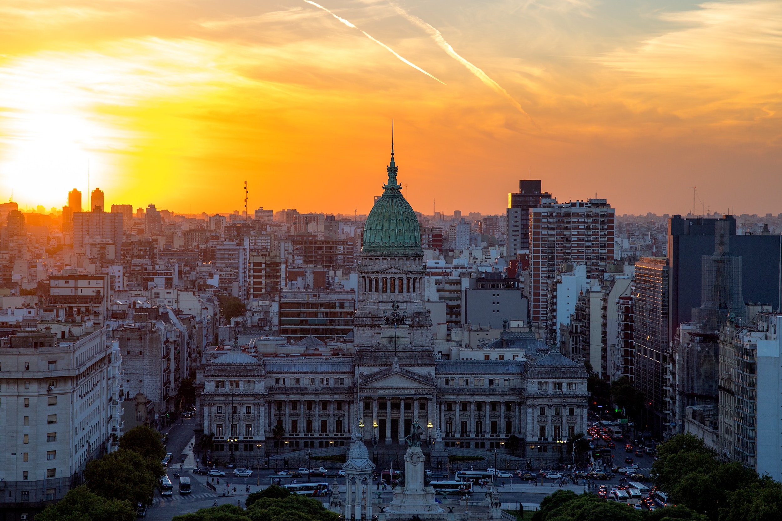
About Buenos Aires
Glamorous and gritty, Buenos Aires is two cities in one. What makes Argentina's capital so fascinating is its dual heritage—part European, part Latin American. Plaza de Mayo resembles a grand square in Madrid, and the ornate Teatro Colón would not be out of place in Vienna. But you’ll know you’re in South America by the leather shoes for sale on cobbled streets and impromptu parades of triumphant soccer fans. Limited-production wines, juicy steaks, and ice cream in countless flavors are among the old-world imports the city has perfected.
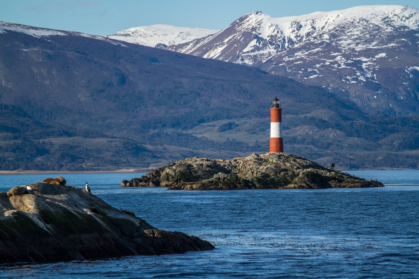
About Ushuaia
At 55 degrees latitude south, Ushuaia (pronounced oo-swy-ah) is closer to the South Pole than to Argentina's northern border with Bolivia. It is the capital and tourism base for Tierra del Fuego, the island at the southernmost tip of Argentina.Although its stark physical beauty is striking, Tierra del Fuego's historical allure is based more on its mythical past than on rugged reality. The island was inhabited for 6,000 years by Yámana, Haush, Selk'nam, and Alakaluf Indians. But in 1902 Argentina, eager to populate Patagonia to bolster its territorial claims, moved to initiate an Ushuaian penal colony, establishing the permanent settlement of its most southern territories and, by implication, everything in between.When the prison closed in 1947, Ushuaia had a population of about 3,000, made up mainly of former inmates and prison staff. Today the Indians of Darwin's "missing link" theory are long gone—wiped out by diseases brought by settlers and by indifference to their plight—and the 60,000 residents of Ushuaia are hitching their star to tourism.The city rightly (if perhaps too loudly) promotes itself as the southernmost city in the world (Puerto Williams, a few miles south on the Chilean side of the Beagle Channel, is a small town). You can make your way to the tourism office to get your clichéd, but oh-so-necessary, "Southernmost City in the World" passport stamp. Ushuaia feels like a frontier boomtown, at heart still a rugged, weather-beaten fishing village, but exhibiting the frayed edges of a city that quadrupled in size in the '70s and '80s and just keeps growing. Unpaved portions of Ruta 3, the last stretch of the Pan-American Highway, which connects Alaska to Tierra del Fuego, are finally being paved. The summer months (December through March) draw more than 120,000 visitors, and dozens of cruise ships. The city is trying to extend those visits with events like March's Marathon at the End of the World and by increasing the gamut of winter activities buoyed by the excellent snow conditions.A terrific trail winds through the town up to the Martial Glacier, where a ski lift can help cut down a steep kilometer of your journey. The chaotic and contradictory urban landscape includes a handful of luxury hotels amid the concrete of public housing projects. Scores of "sled houses" (wooden shacks) sit precariously on upright piers, ready for speedy displacement to a different site. But there are also many small, picturesque homes with tiny, carefully tended gardens. Many of the newer homes are built in a Swiss-chalet style, reinforcing the idea that this is a town into which tourism has breathed new life. At the same time, the weather-worn pastel colors that dominate the town's landscape remind you that Ushuaia was once just a tiny fishing village, snuggled at the end of the Earth.As you stand on the banks of the Canal Beagle (Beagle Channel) near Ushuaia, the spirit of the farthest corner of the world takes hold. What stands out is the light: at sundown the landscape is cast in a subdued, sensual tone; everything feels closer, softer, and more human in dimension despite the vastness of the setting. The snowcapped mountains reflect the setting sun back onto a stream rolling into the channel, as nearby peaks echo their image—on a windless day—in the still waters.Above the city rise the last mountains of the Andean Cordillera, and just south and west of Ushuaia they finally vanish into the often-stormy sea. Snow whitens the peaks well into summer. Nature is the principal attraction here, with trekking, fishing, horseback riding, wildlife spotting, and sailing among the most rewarding activities, especially in the Parque Nacional Tierra del Fuego (Tierra del Fuego National Park).

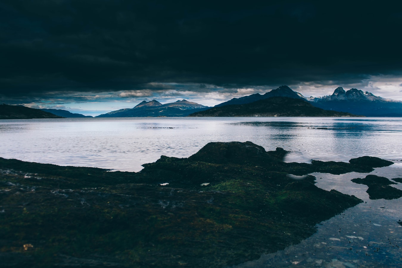
About Antarctic Peninsula
Remote and otherworldly, Antarctic is irresistible for its spectacular iceberg sculptures and calving glaciers, and for the possibility of up-close encounters with marine mammals and the iconic penguins. The Antarctic Peninsula – the main peninsula closest to South America – has a human history of almost 200 years, with explorers, sealers, whalers, and scientists who have come to work, and eventually intrepid visitors coming to enjoy this pristine and remote wilderness. It is a region of protected bays, unscaled snow-capped mountains, vast glaciers and a few places where whalers or scientists have worked. Just as irresistible are the many Gentoo and Chinstrap Penguin colonies, the seals basking on ice floes, the whales and orcas.
About Ushuaia
At 55 degrees latitude south, Ushuaia (pronounced oo-swy-ah) is closer to the South Pole than to Argentina's northern border with Bolivia. It is the capital and tourism base for Tierra del Fuego, the island at the southernmost tip of Argentina.Although its stark physical beauty is striking, Tierra del Fuego's historical allure is based more on its mythical past than on rugged reality. The island was inhabited for 6,000 years by Yámana, Haush, Selk'nam, and Alakaluf Indians. But in 1902 Argentina, eager to populate Patagonia to bolster its territorial claims, moved to initiate an Ushuaian penal colony, establishing the permanent settlement of its most southern territories and, by implication, everything in between.When the prison closed in 1947, Ushuaia had a population of about 3,000, made up mainly of former inmates and prison staff. Today the Indians of Darwin's "missing link" theory are long gone—wiped out by diseases brought by settlers and by indifference to their plight—and the 60,000 residents of Ushuaia are hitching their star to tourism.The city rightly (if perhaps too loudly) promotes itself as the southernmost city in the world (Puerto Williams, a few miles south on the Chilean side of the Beagle Channel, is a small town). You can make your way to the tourism office to get your clichéd, but oh-so-necessary, "Southernmost City in the World" passport stamp. Ushuaia feels like a frontier boomtown, at heart still a rugged, weather-beaten fishing village, but exhibiting the frayed edges of a city that quadrupled in size in the '70s and '80s and just keeps growing. Unpaved portions of Ruta 3, the last stretch of the Pan-American Highway, which connects Alaska to Tierra del Fuego, are finally being paved. The summer months (December through March) draw more than 120,000 visitors, and dozens of cruise ships. The city is trying to extend those visits with events like March's Marathon at the End of the World and by increasing the gamut of winter activities buoyed by the excellent snow conditions.A terrific trail winds through the town up to the Martial Glacier, where a ski lift can help cut down a steep kilometer of your journey. The chaotic and contradictory urban landscape includes a handful of luxury hotels amid the concrete of public housing projects. Scores of "sled houses" (wooden shacks) sit precariously on upright piers, ready for speedy displacement to a different site. But there are also many small, picturesque homes with tiny, carefully tended gardens. Many of the newer homes are built in a Swiss-chalet style, reinforcing the idea that this is a town into which tourism has breathed new life. At the same time, the weather-worn pastel colors that dominate the town's landscape remind you that Ushuaia was once just a tiny fishing village, snuggled at the end of the Earth.As you stand on the banks of the Canal Beagle (Beagle Channel) near Ushuaia, the spirit of the farthest corner of the world takes hold. What stands out is the light: at sundown the landscape is cast in a subdued, sensual tone; everything feels closer, softer, and more human in dimension despite the vastness of the setting. The snowcapped mountains reflect the setting sun back onto a stream rolling into the channel, as nearby peaks echo their image—on a windless day—in the still waters.Above the city rise the last mountains of the Andean Cordillera, and just south and west of Ushuaia they finally vanish into the often-stormy sea. Snow whitens the peaks well into summer. Nature is the principal attraction here, with trekking, fishing, horseback riding, wildlife spotting, and sailing among the most rewarding activities, especially in the Parque Nacional Tierra del Fuego (Tierra del Fuego National Park).
About Buenos Aires
Glamorous and gritty, Buenos Aires is two cities in one. What makes Argentina's capital so fascinating is its dual heritage—part European, part Latin American. Plaza de Mayo resembles a grand square in Madrid, and the ornate Teatro Colón would not be out of place in Vienna. But you’ll know you’re in South America by the leather shoes for sale on cobbled streets and impromptu parades of triumphant soccer fans. Limited-production wines, juicy steaks, and ice cream in countless flavors are among the old-world imports the city has perfected.


Where You'll Go


