Yachting the Adriatic
Yachting the Adriatic
Cruise overview
WHY BOOK WITH US?
- ✔ The Deluxe Cruises’ team has extensive experience in ultra-luxury cruising.
- ✔ Call now to speak to our helpful and experienced Cruise Concierge team.
- ✔ Enjoy our Unique Deluxe Cruises Bonus for substantial savings.
- ✔ Our team will tailor your holiday to your exacting requirements.
- ✔ As agents, we work under the protection of each cruise lines ABTA / ATOL licences
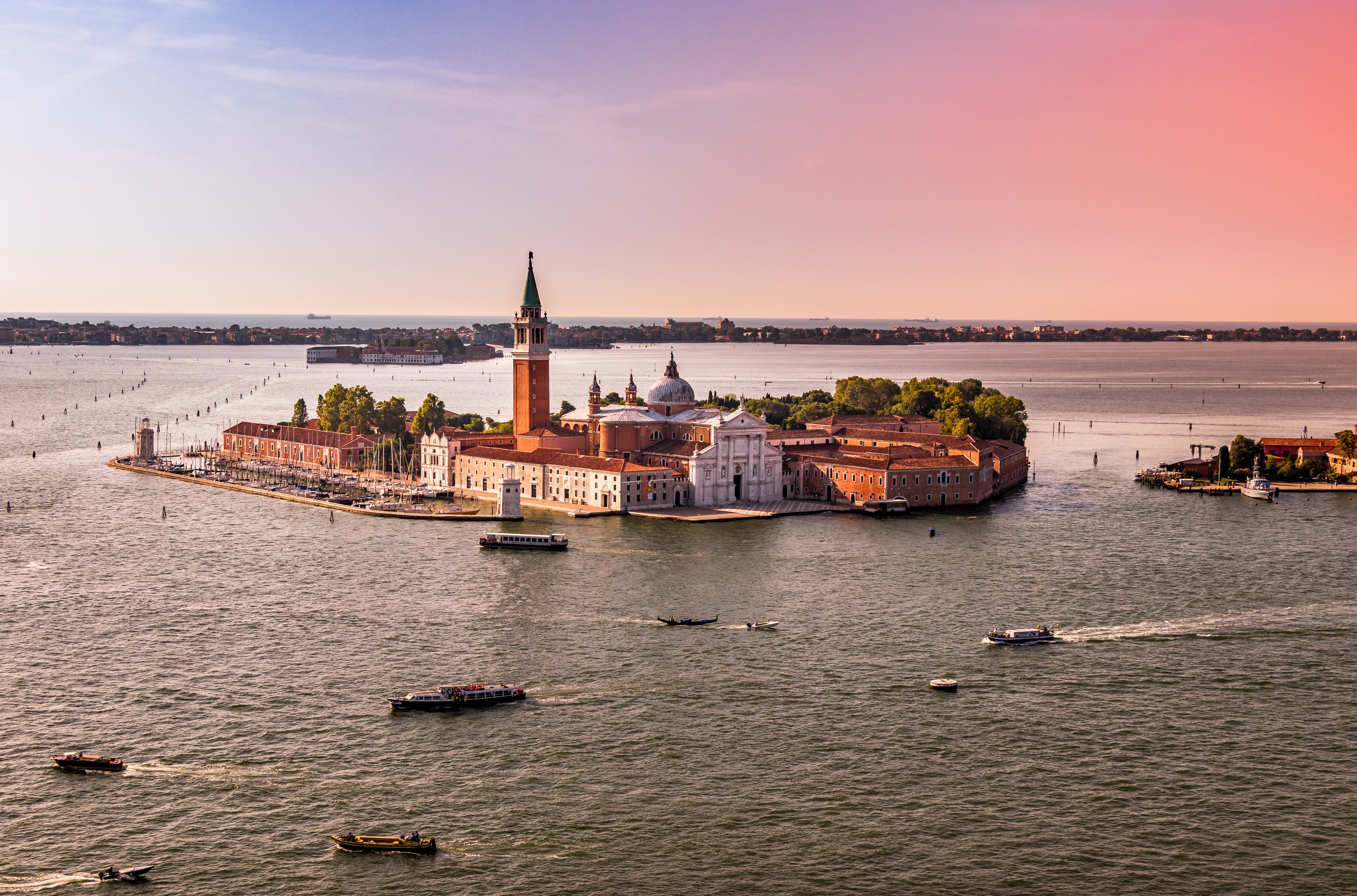
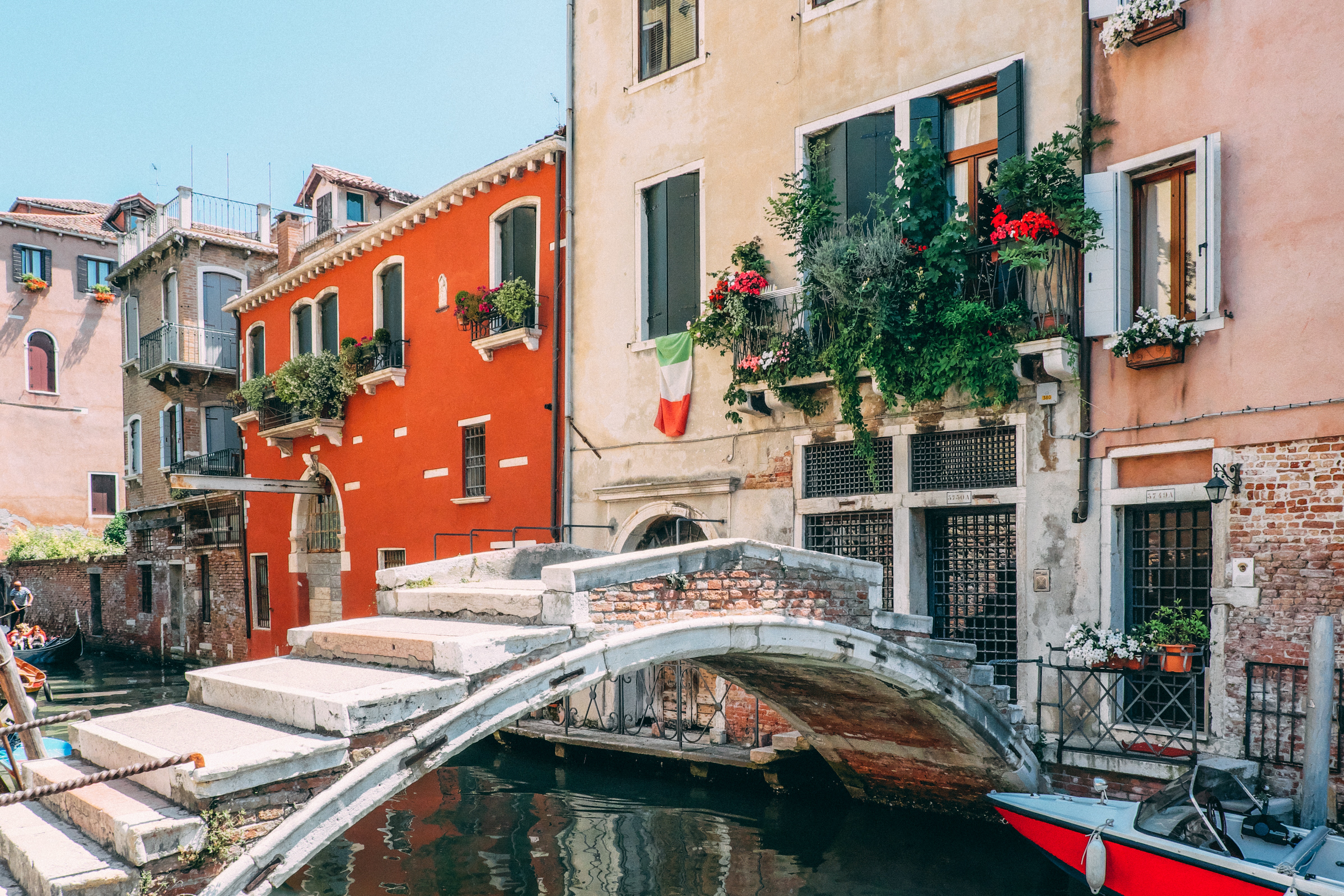
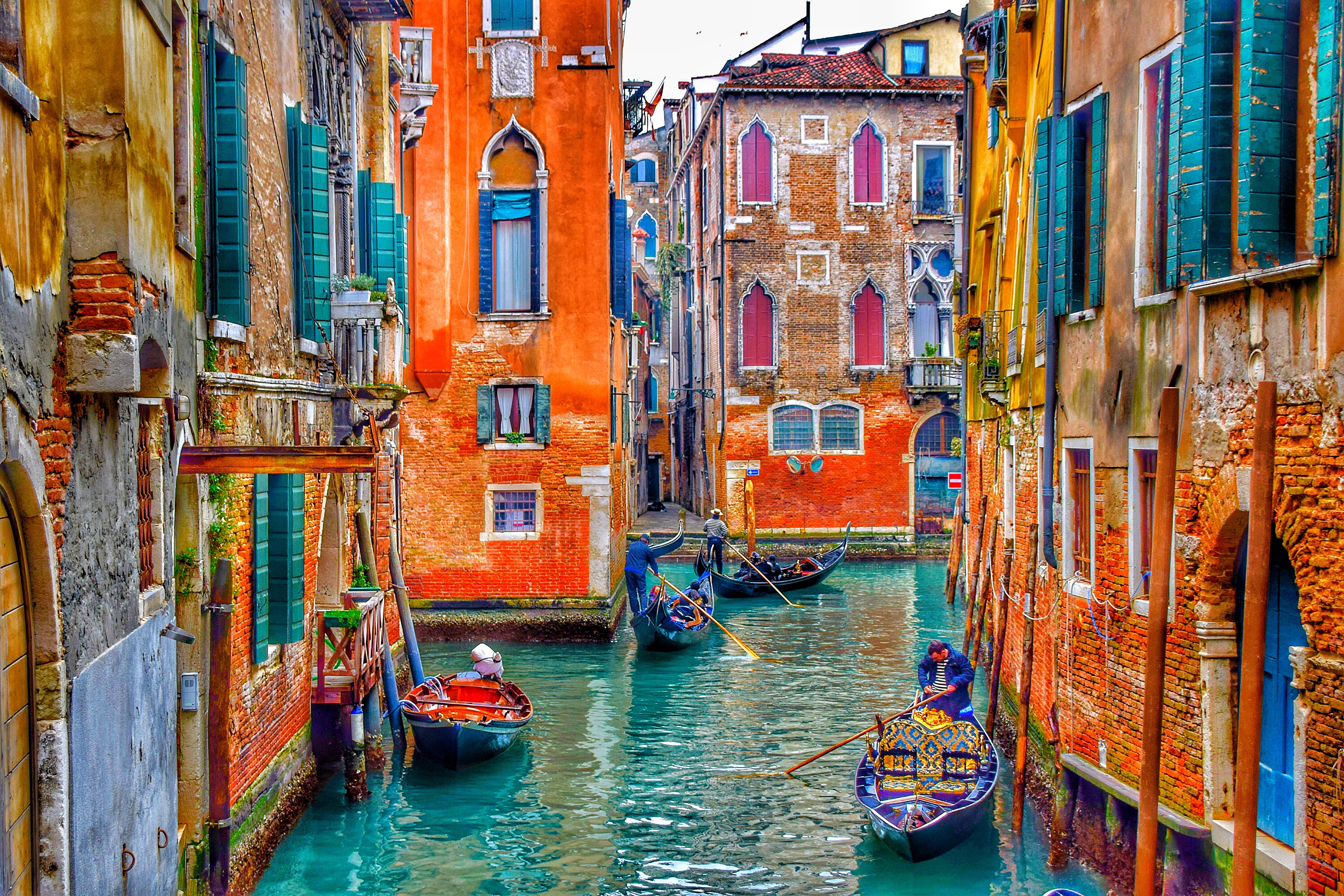
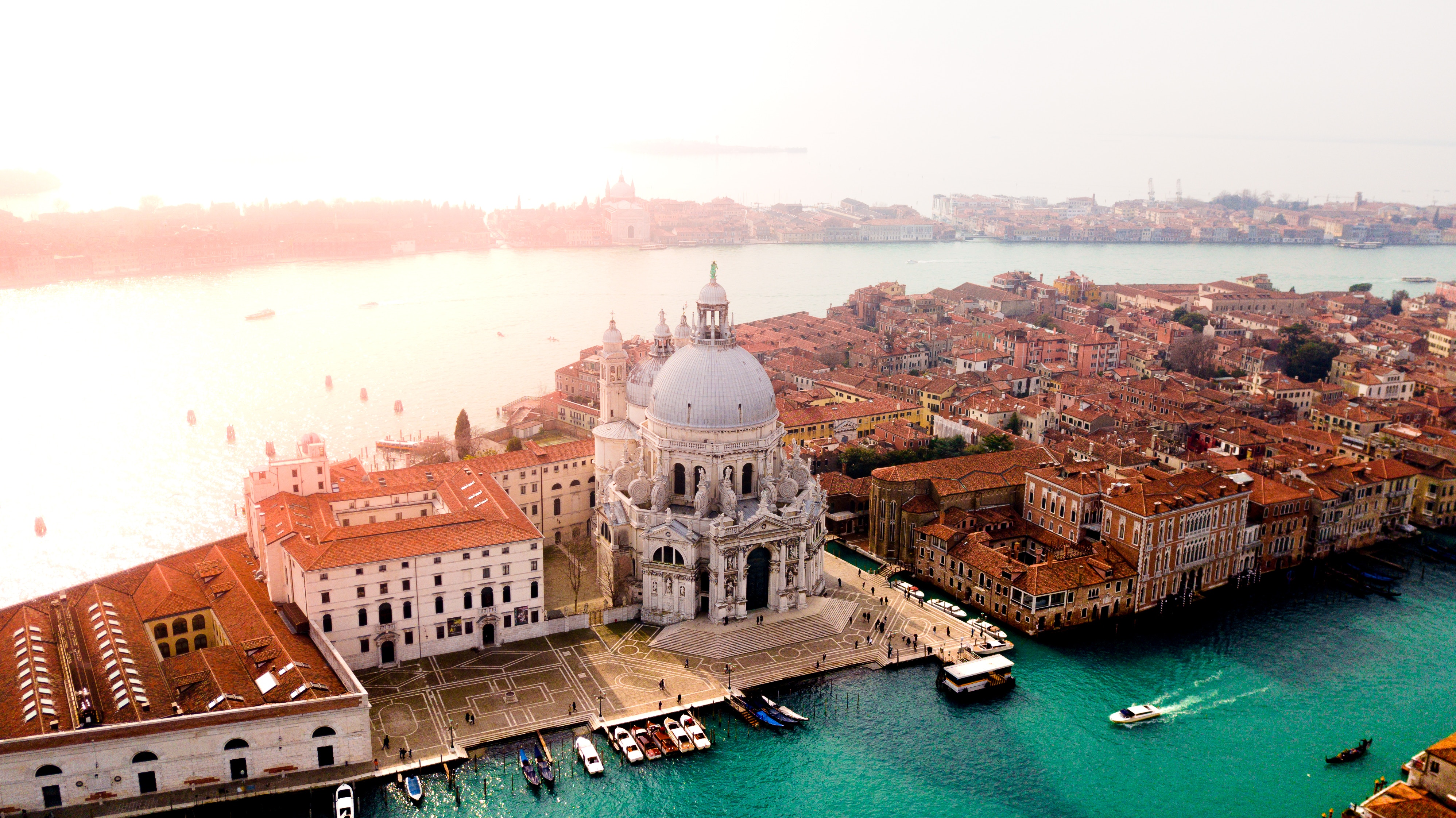
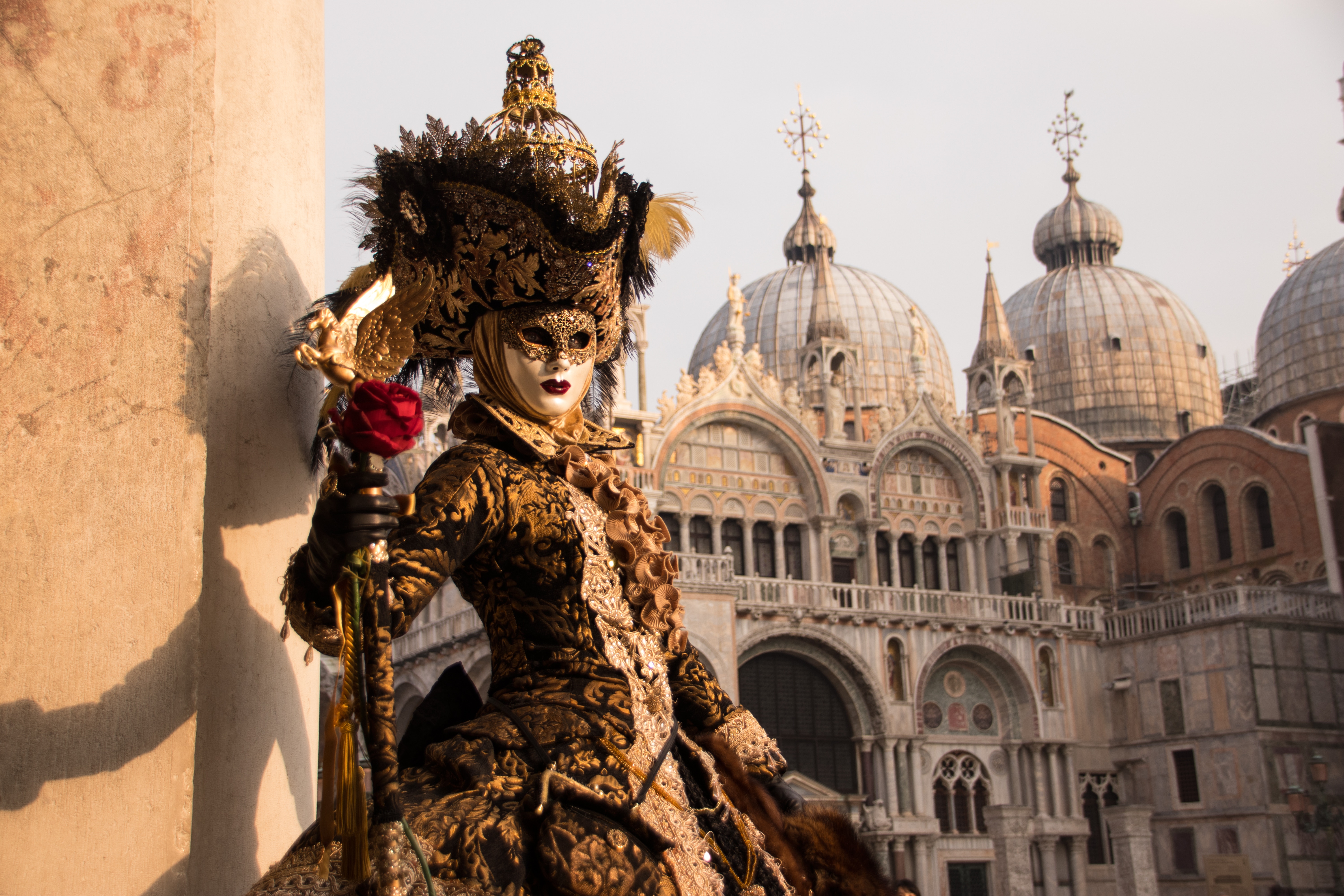
About Venice
Venice is a city unlike any other. No matter how often you've seen it in photos and films, the real thing is more dreamlike than you could imagine. With canals where streets should be, water shimmers everywhere. The fabulous palaces and churches reflect centuries of history in what was a wealthy trading center between Europe and the Orient. Getting lost in the narrow alleyways is a quintessential part of exploring Venice, but at some point you'll almost surely end up in Piazza San Marco, where tourists and locals congregate for a coffee or an aperitif.

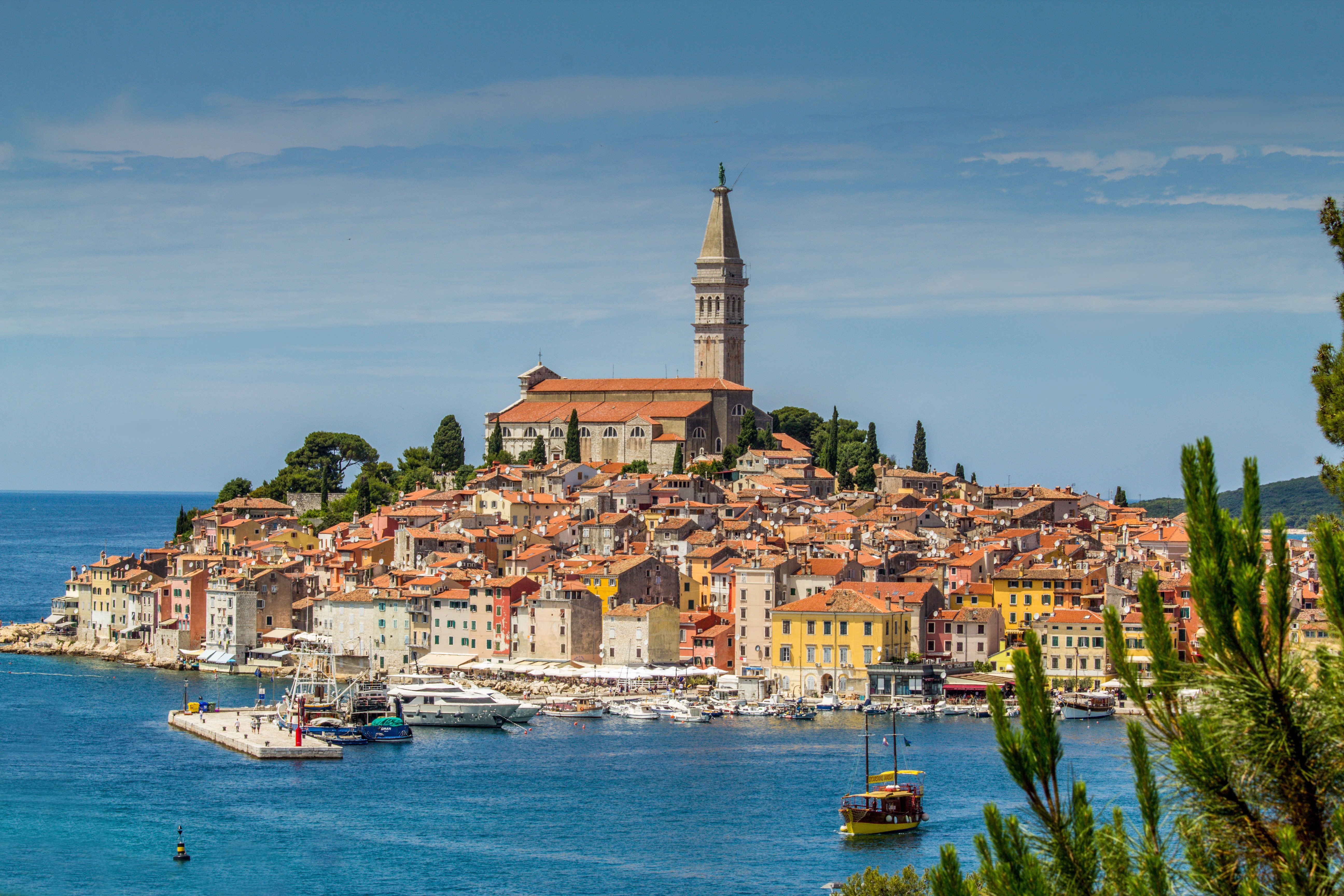
About Rovinj
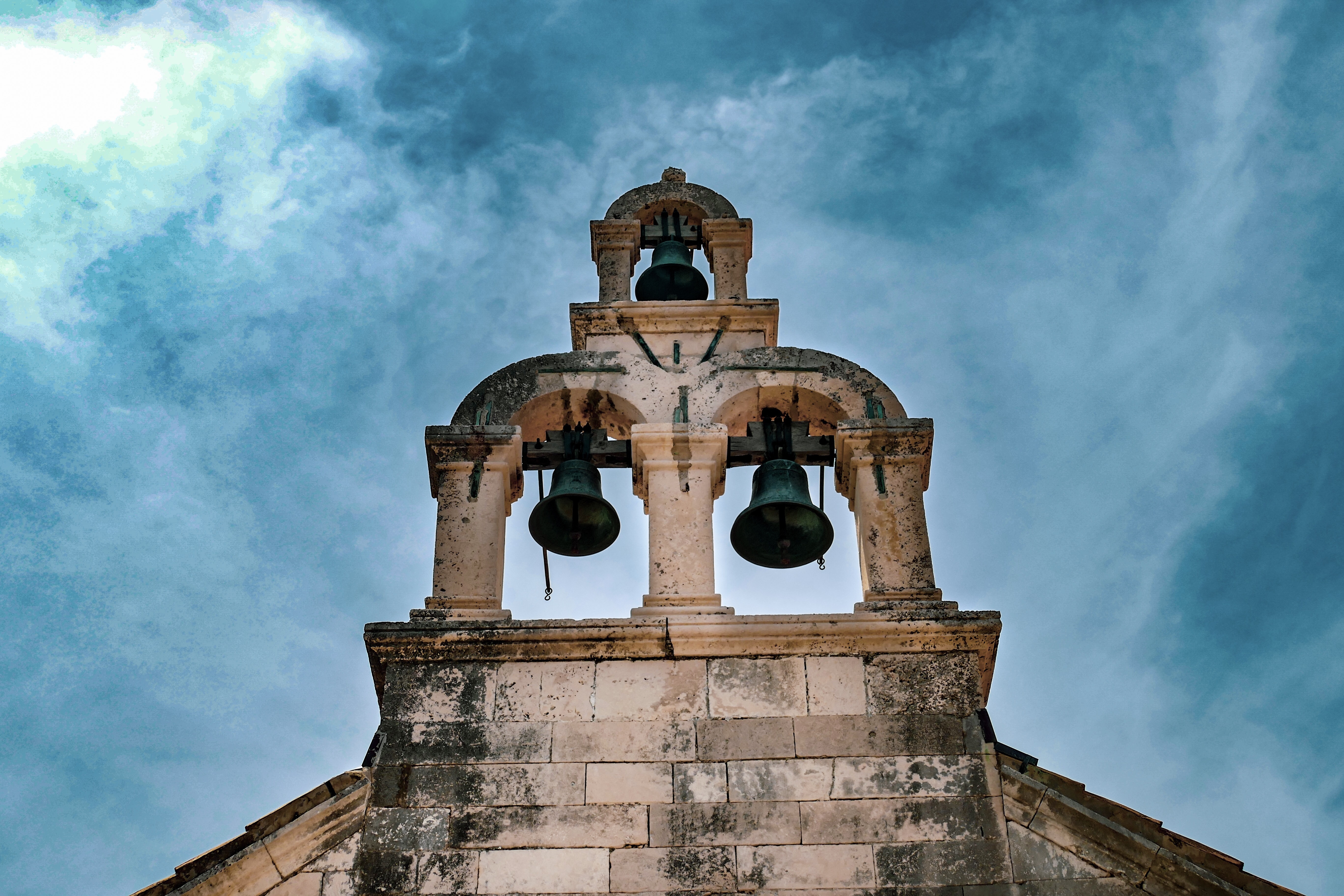
One of the true jewels of the Mediterranean, Rovinj is a jaw-droppingly beautiful town, which juts out into sparkling Mediterranean. Dominated by the pencil-like bell tower of the Venetian Saint Euphemia Cathedral, pine tree forests flow to the borders of the quaint Old Town - which evokes the romantic, tangled backstreets of the Venice. Rovinj - or Rovino in Italian - is a city of split personalities, with two official languages - having been owned by the Kingdom of Italy between 1919 and 1947.
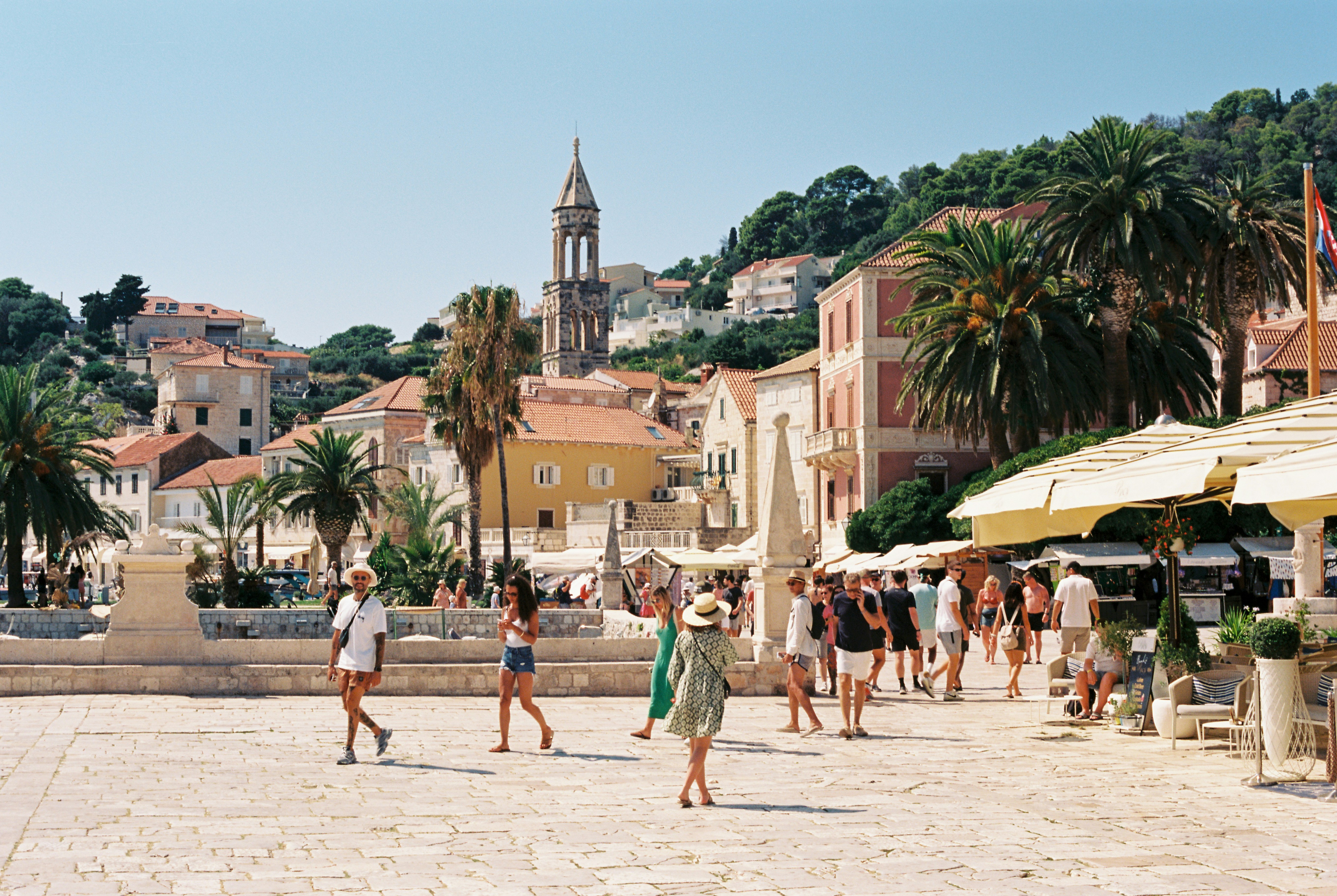
About Hvar Island
The Croatian island of Hvar bills itself as the "sunniest island in the Adriatic." Not only does it have the figures to back up this claim—an annual average of 2,724 hours of sunshine—but it also makes visitors a sporting proposition, offering them a money-back guarantee if there are seven consecutive days of snow (snow has been known to fall here; the last time being February 2012).
About Komiza

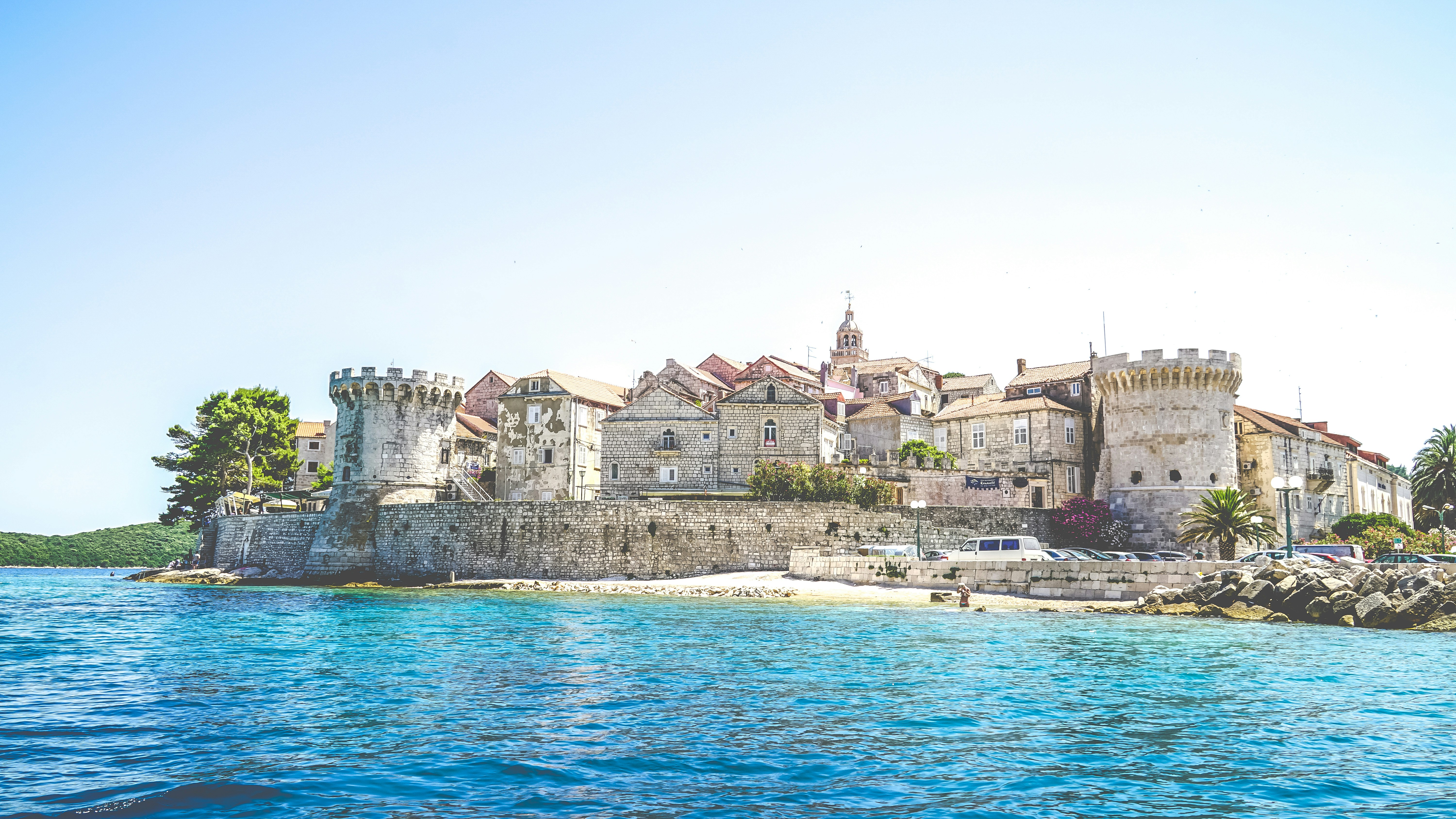
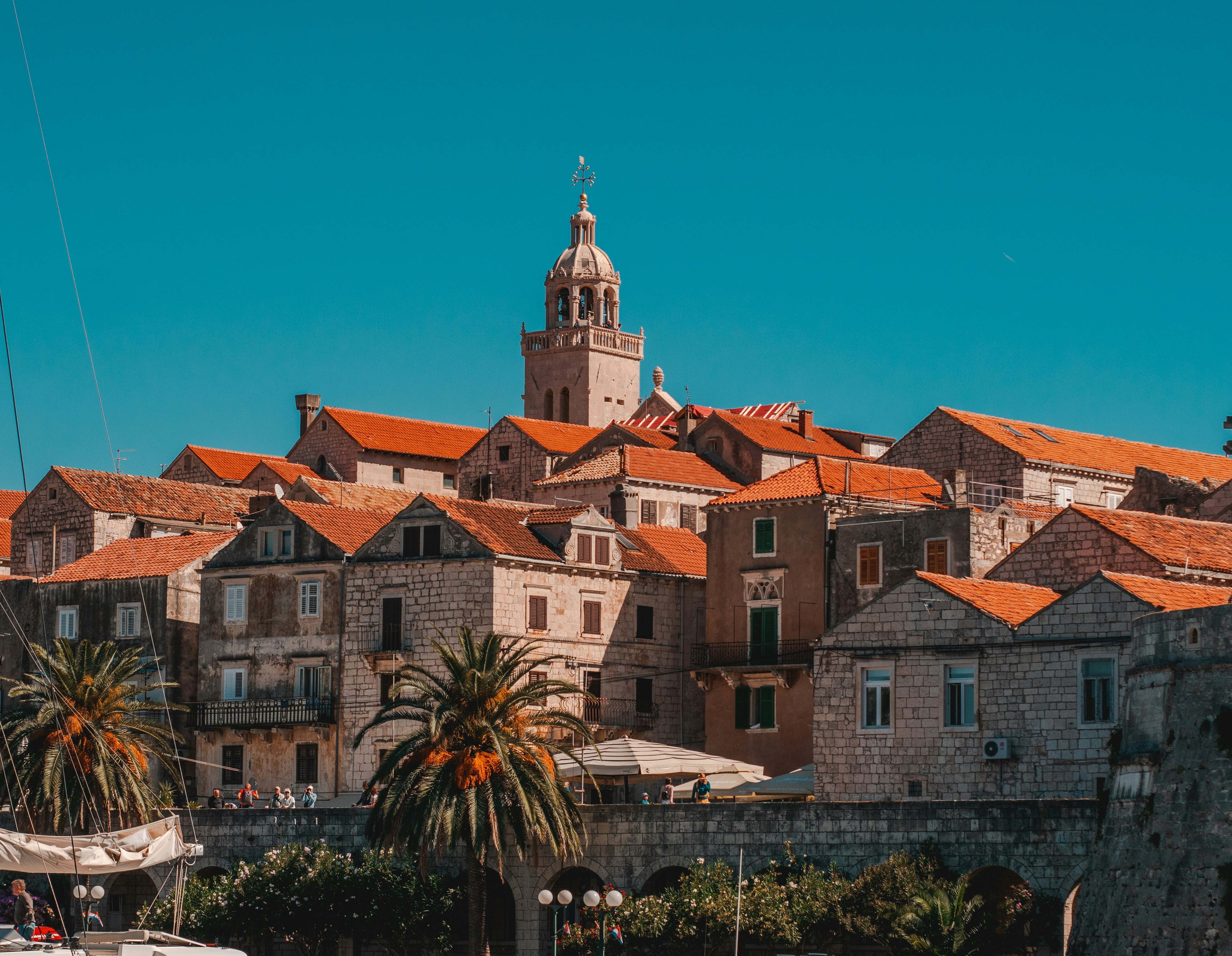
About Korčula
Off the coast of Croatia in the southern Adriatic Sea lie some thousand islands and the largest of them, Korçula, is considered the most beautiful. With an average of 3,000 hours of sunshine per annum, which guarantees a wide assortment of Mediterranean vegetation, it is not difficult to understand why seasoned travelers compare Korçula to a latter-day Eden. Separated from the mainland by a channel of only one mile, Korçula's main town, named the same as the island, ranks among the best preserved medieval towns in the Mediterranean. It is the island's main tourist, economic and cultural center. Thanks to its strategic location along the sea trade routes, Korçula has always attracted travelers and settlers. Korcula was founded by Greek colonists, who were followed by Illyrians, Romans and finally the Croats. The Korçula Statute of 1214 is one of the oldest legal documents to have been adopted in this part of Europe. The same century saw the birth of the famous world traveler, Marco Polo. The house said to be his birthplace can be seen in town. Korçulans have always been known as keen seafarers, excellent shipbuilders, stonemasons and artists. From their many voyages, sailors brought back new ideas, which eventually mixed with local customs. To this day, Korçula has maintained the tradition of performing knightly games such as the chivalrous Moreska dance, which has been in existence for more than 400 years. Visitors to Korçula enjoy its stunning location, natural beauty and medieval ambiance. And if that's not enough, the town offers numerous attractions that are within walking distance from the pier, including the City Museum and the Bishop's Treasury.
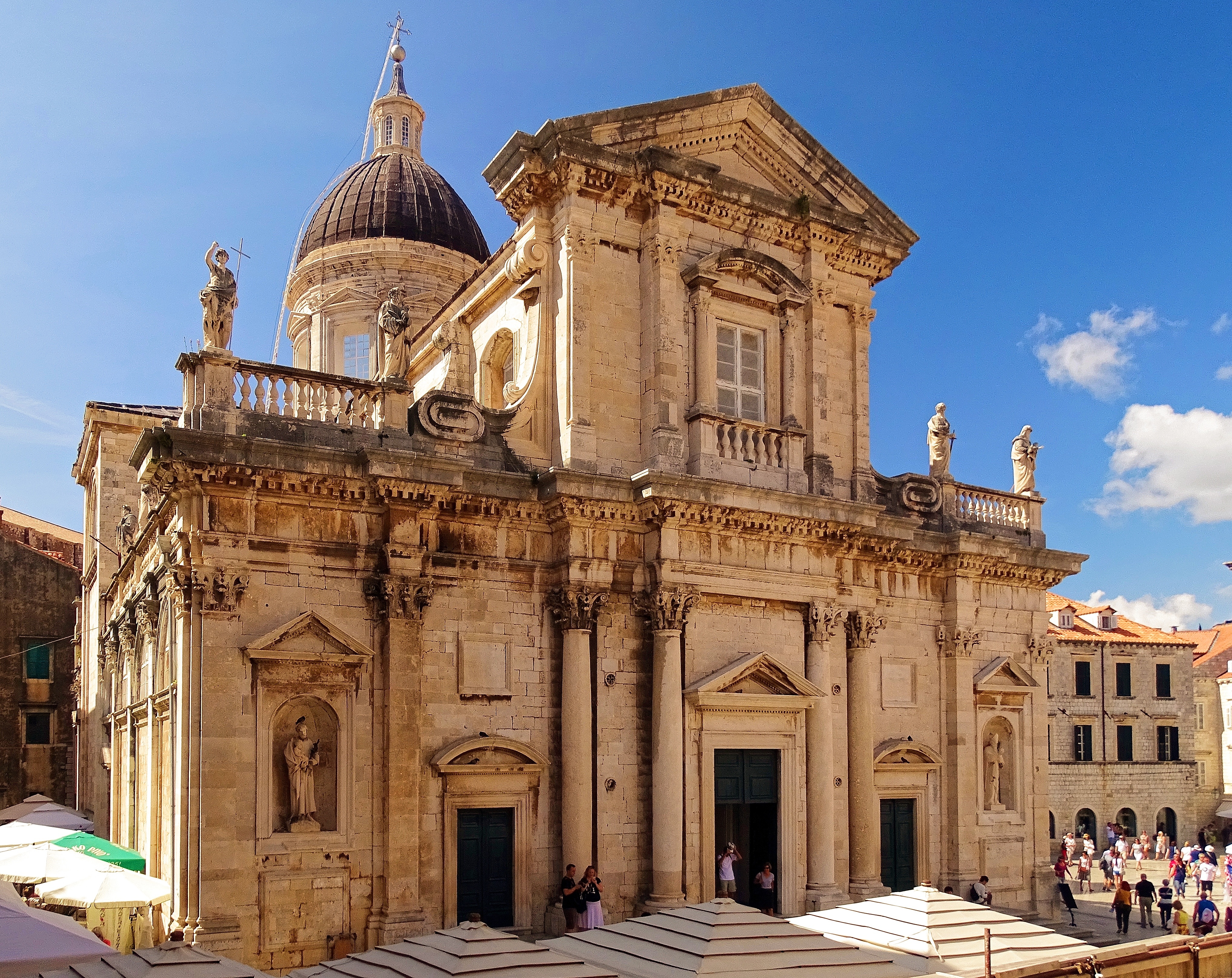
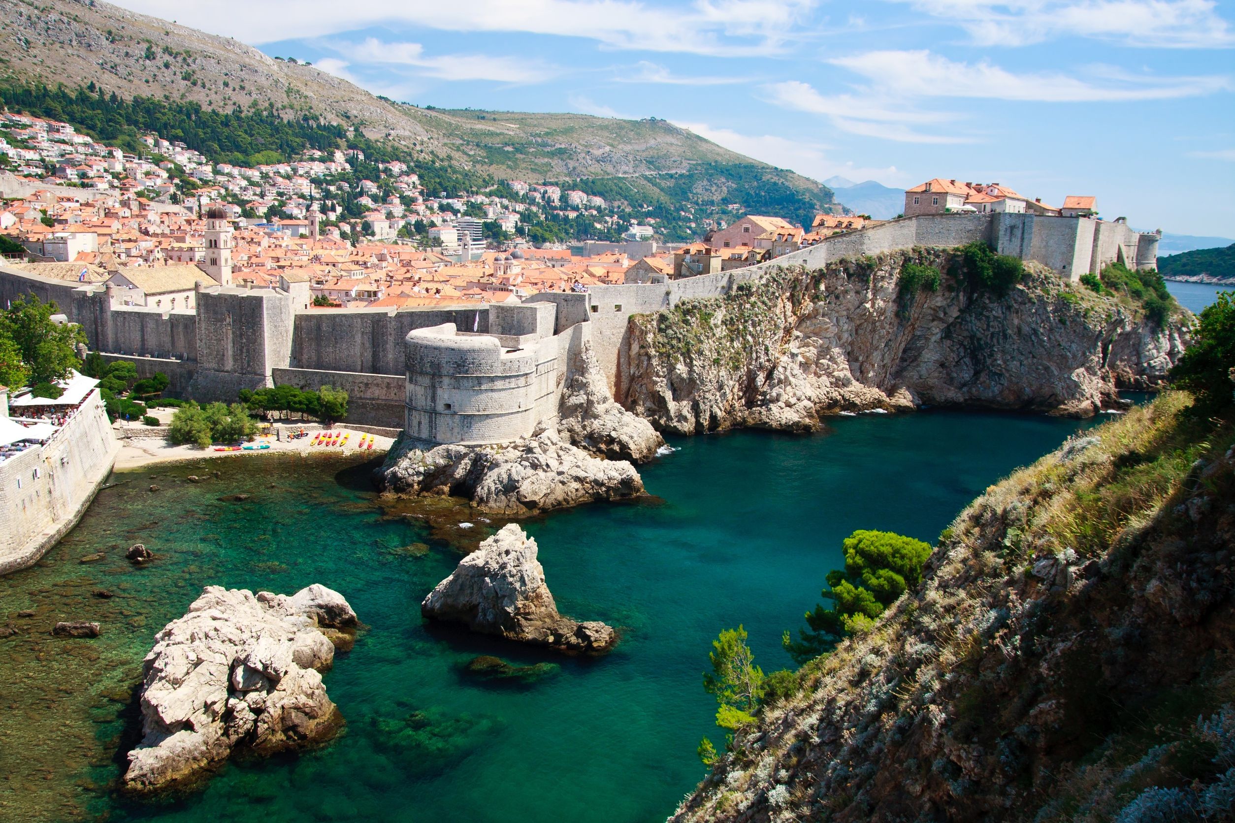
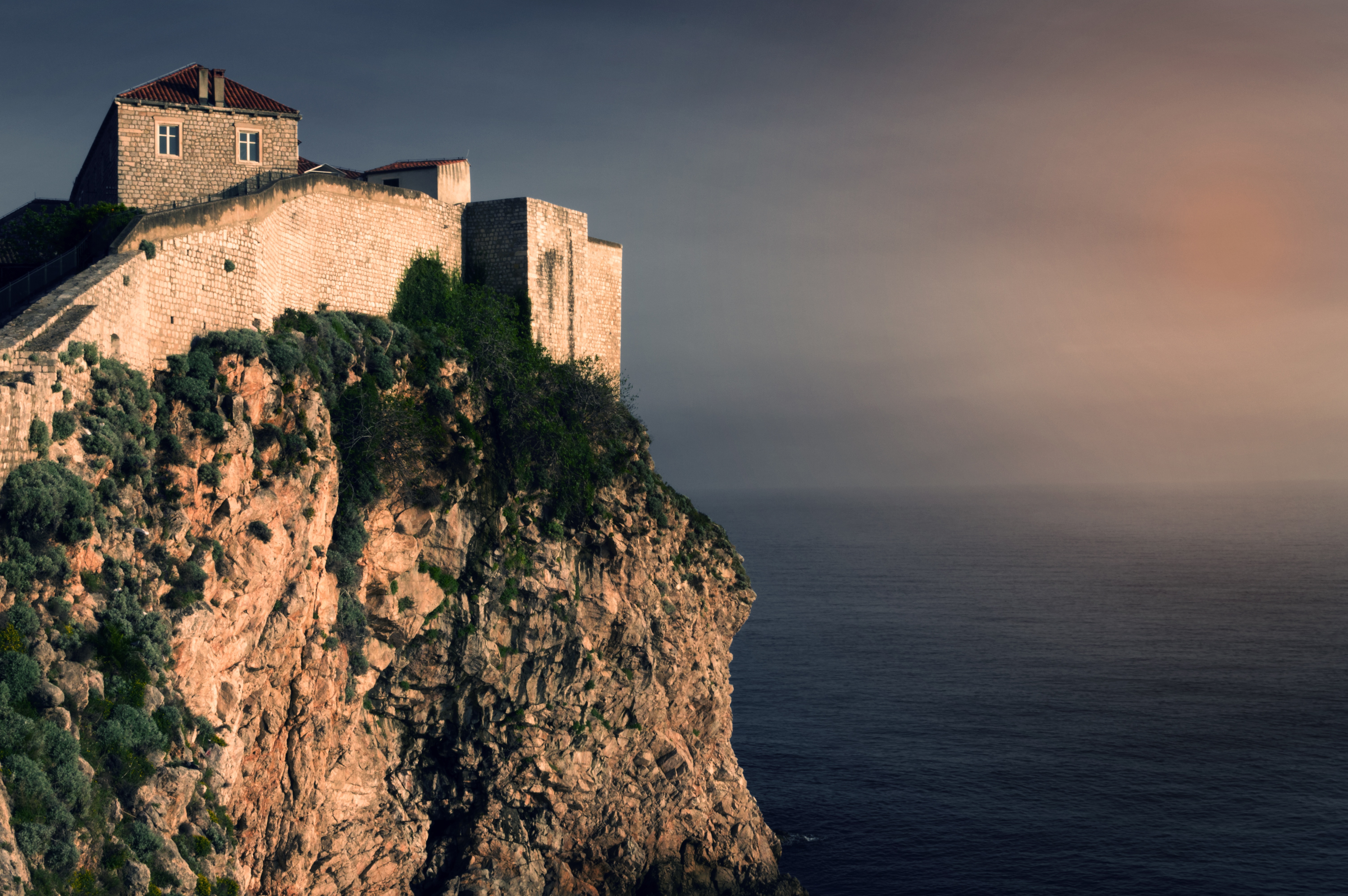
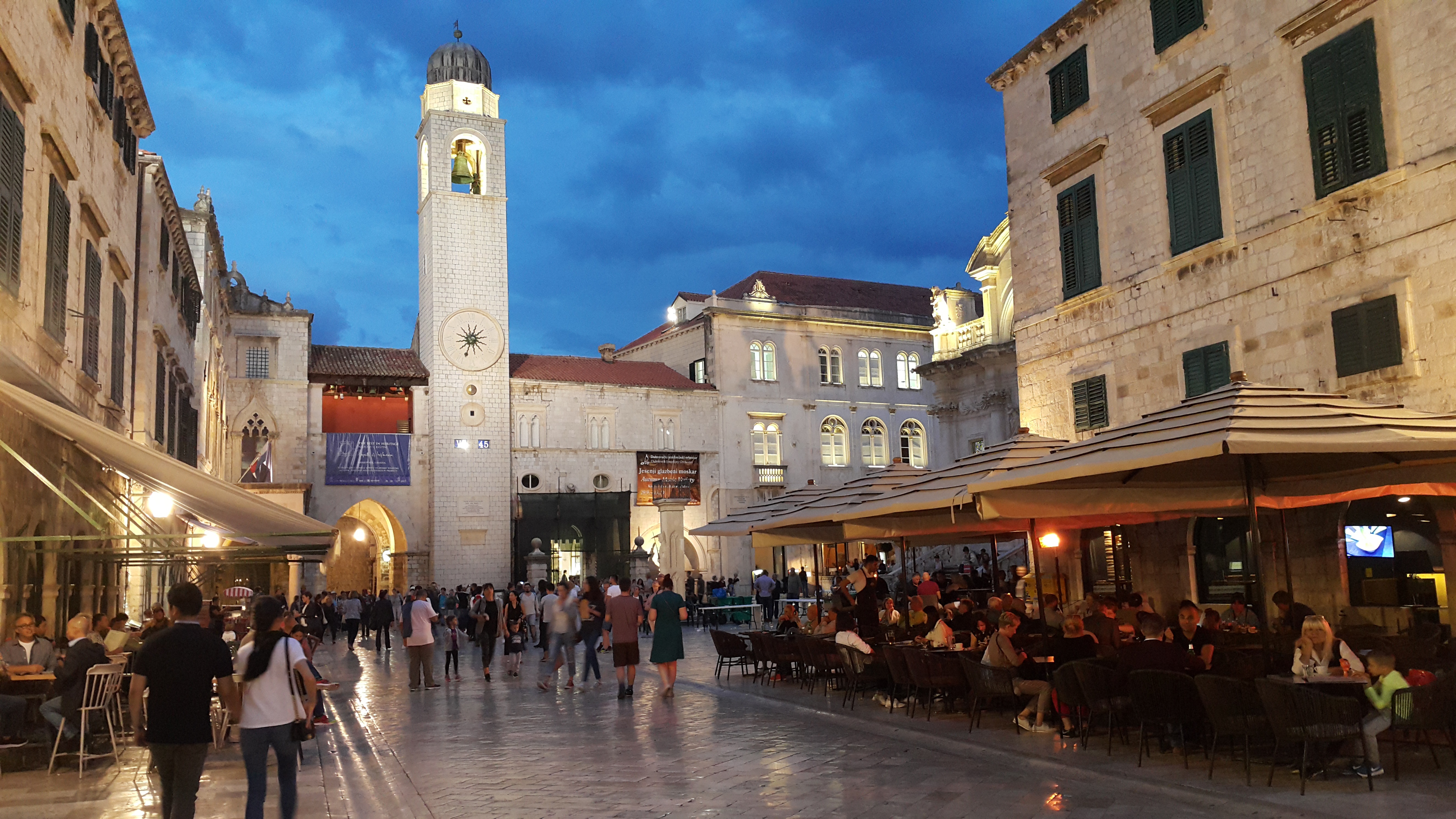
About Dubrovnik
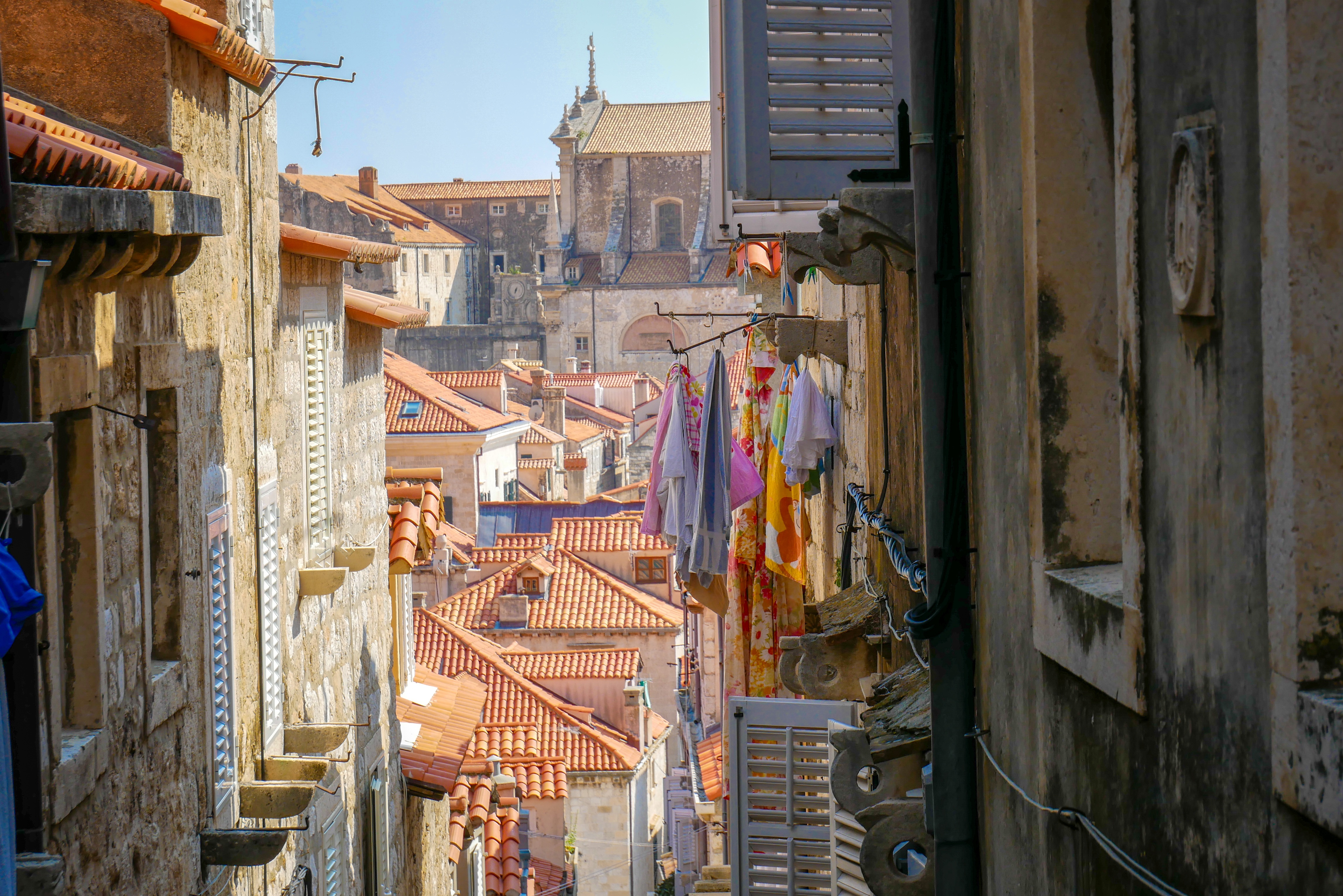
Nothing can prepare you for your first sight of Dubrovnik. Lying 216 km (135 miles) southeast of Split and commanding a jaw-dropping coastal location, it is one of the world's most beautiful fortified cities. Its massive stone ramparts and fortress towers curve around a tiny harbor, enclosing graduated ridges of sun-bleached orange-tiled roofs, copper domes, and elegant bell towers. Your imagination will run wild picturing what it looked like seven centuries ago when the walls were built, without any suburbs or highways around it, just this magnificent stone city rising out of the sea.In the 7th century AD, residents of the Roman city Epidaurum (now Cavtat) fled the Avars and Slavs of the north and founded a new settlement on a small rocky island, which they named Laus, and later Ragusa. On the mainland hillside opposite the island, the Slav settlement called Dubrovnik grew up. In the 12th century the narrow channel separating the two settlements was filled in (now the main street through the Old Town, called Stradun), and Ragusa and Dubrovnik became one. The city was surrounded by defensive walls during the 13th century, and these were reinforced with towers and bastions in the late 15th century.From 1358 to 1808 the city thrived as a powerful and remarkably sophisticated independent republic, reaching its golden age during the 16th century. In 1667 many of its splendid Gothic and Renaissance buildings were destroyed by an earthquake. The defensive walls survived the disaster, and the city was rebuilt in baroque style.Dubrovnik lost its independence to Napoléon in 1808, and in 1815 passed to Austria-Hungary. During the 20th century, as part of Yugoslavia, the city became a popular tourist destination, and in 1979 it was listed as a UNESCO World Heritage Site. During the war for independence, it came under heavy siege. Thanks to careful restoration, few traces of damage remain; however, there are maps inside the Pile and Ploče Gates illustrating the points around the city where damage was done. It’s only when you experience Dubrovnik yourself that you can understand what a treasure the world nearly lost
About Kotor
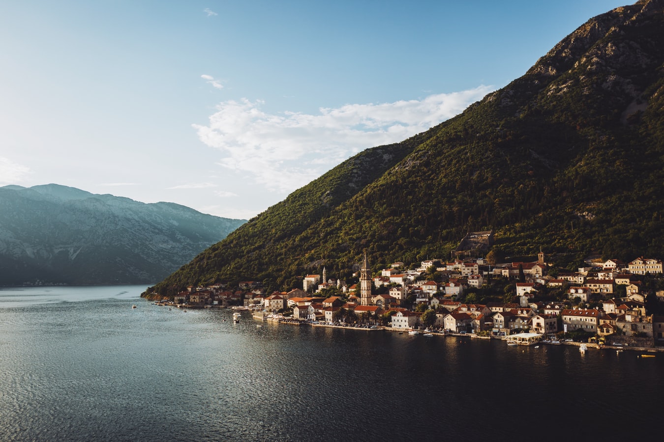
Backed by imposing mountains, tiny Kotor lies hidden from the open sea, tucked into the deepest channel of the Bokor Kotorska (Kotor Bay), which is Europe's most southerly fjord. To many, this town is more charming than its sister UNESCO World Heritage Site, Dubrovnik, retaining more authenticity, but with fewer tourists and spared the war damage and subsequent rebuilding which has given Dubrovnik something of a Disney feel.Kotor's medieval Stari Grad (Old Town) is enclosed within well-preserved defensive walls built between the 9th and 18th centuries and is presided over by a proud hilltop fortress. Within the walls, a labyrinth of winding cobbled streets leads through a series of splendid paved piazzas, rimmed by centuries-old stone buildings. The squares are now haunted by strains from buskers but although many now house trendy cafés and chic boutiques, directions are still given medieval-style by reference to the town’s landmark churches.In the Middle Ages, as Serbia's chief port, Kotor was an important economic and cultural center with its own highly regarded schools of stonemasonry and iconography. From 1391 to 1420 it was an independent city-republic and later, it spent periods under Venetian, Austrian, and French rule, though it was undoubtedly the Venetians who left the strongest impression on the city's architecture. Since the breakup of Yugoslavia, some 70% of the stone buildings in the romantic Old Town have been snapped up by foreigners, mostly Brits and Russians. Porto Montenegro, a new marina designed to accommodate some of the world’s largest super yachts, opened in nearby Tivat in 2011, and along the bay are other charming seaside villages, all with better views of the bay than the vista from Kotor itself where the waterside is congested with cruise ships and yachts. Try sleepy Muo or the settlement of Prčanj in one direction around the bay, or Perast and the Roman mosaics of Risan in the other direction.
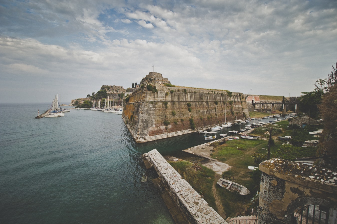
About Corfu
Corfu town today is a vivid tapestry of cultures—a sophisticated weave, where charm, history, and natural beauty blend. Located about midway along the island's east coast, this spectacularly lively capital is the cultural heart of Corfu and has a remarkable historic center that UNESCO designated as a World Heritage Site in 2007. All ships and planes dock or land near Corfu town, which occupies a small peninsula jutting into the Ionian Sea.Whether arriving by ferry from mainland Greece or Italy, from another island, or directly by plane, catch your breath by first relaxing with a coffee or a gelato in Corfu town's shaded Liston Arcade, then stroll the narrow lanes of its pedestrians-only quarter. For an overview of the immediate area, and a quick tour of Mon Repos palace, hop on the little tourist train that runs from May to September. Corfu town has a different feel at night, so book a table at one of its famed tavernas to savor the island's unique cuisine.The best way to get around Corfu town is on foot. The town is small enough so that you can easily walk to every sight. There are local buses, but they do not thread their way into the streets (many now car-free) of the historic center. If you are arriving by ferry or plane, it's best to take a taxi to your hotel. Expect to pay about €10 from the airport or ferry terminal to a hotel in Corfu town. If there are no taxis waiting, you can call for one.
About Fiskárdo
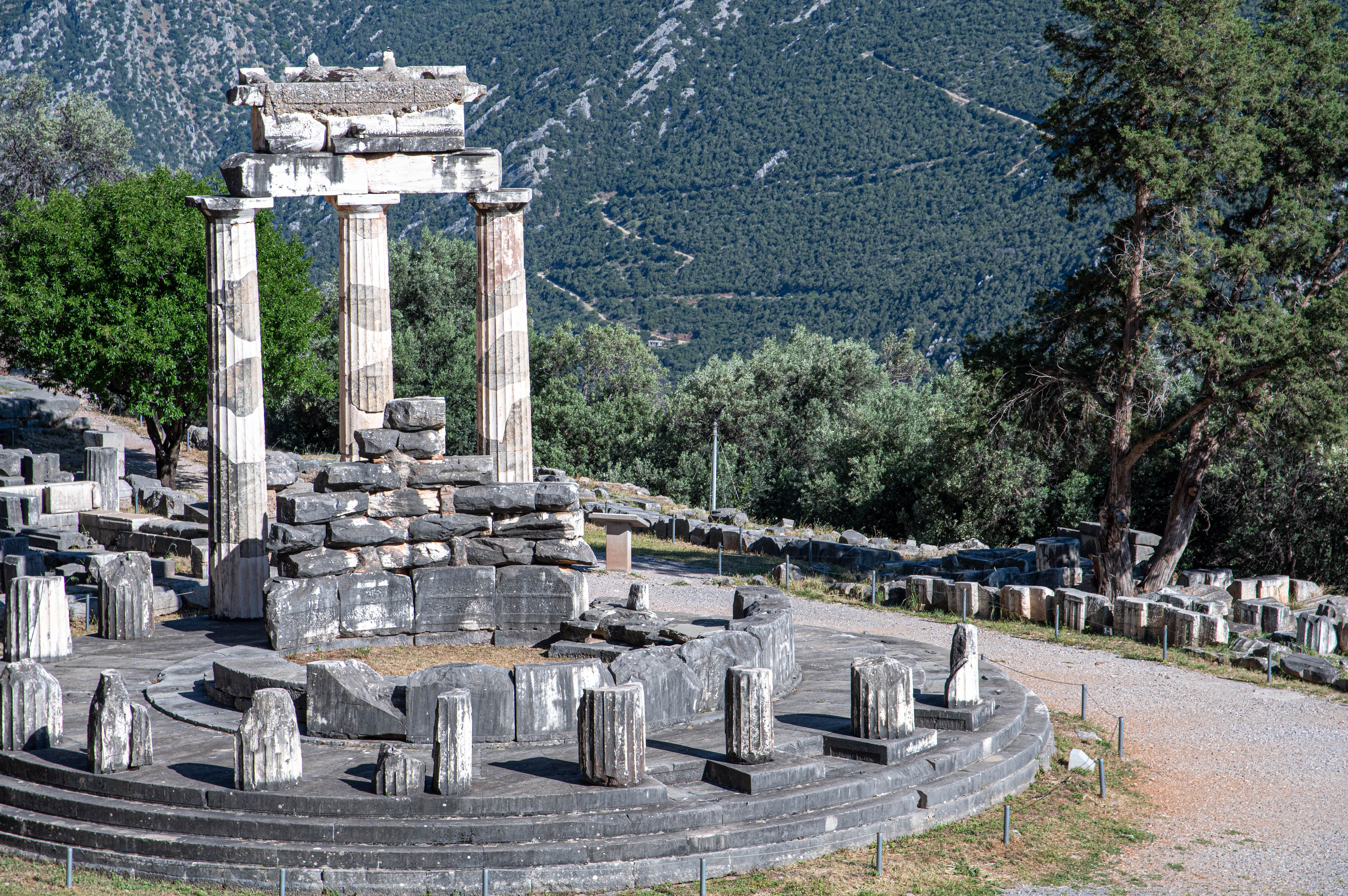
About Delphi
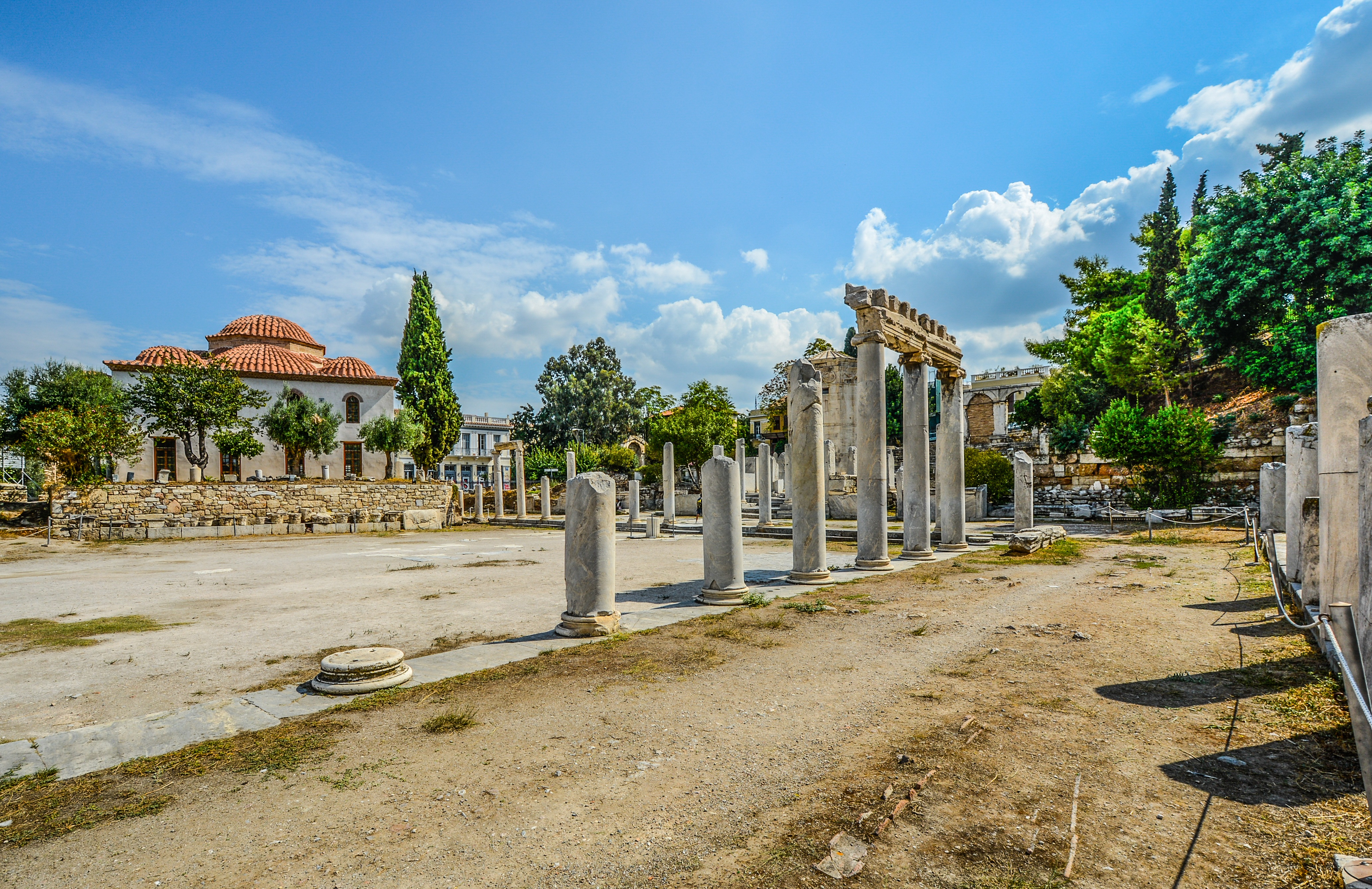
About Piraeus
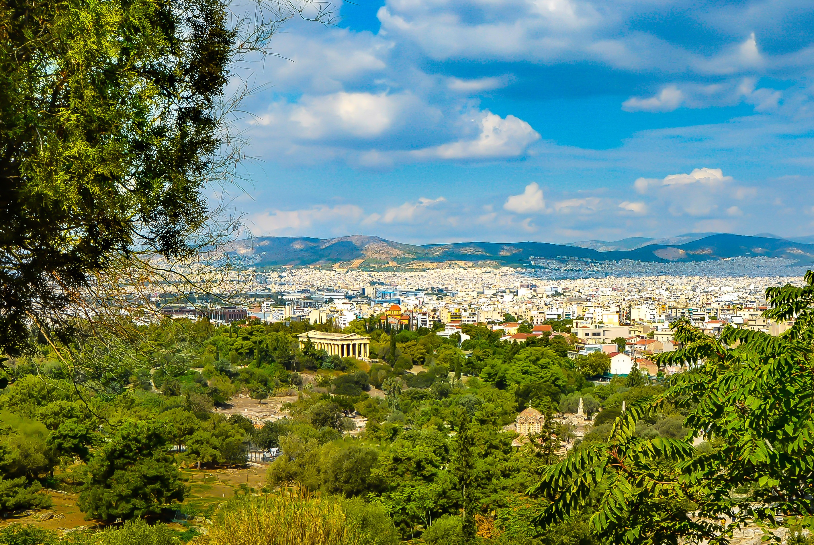
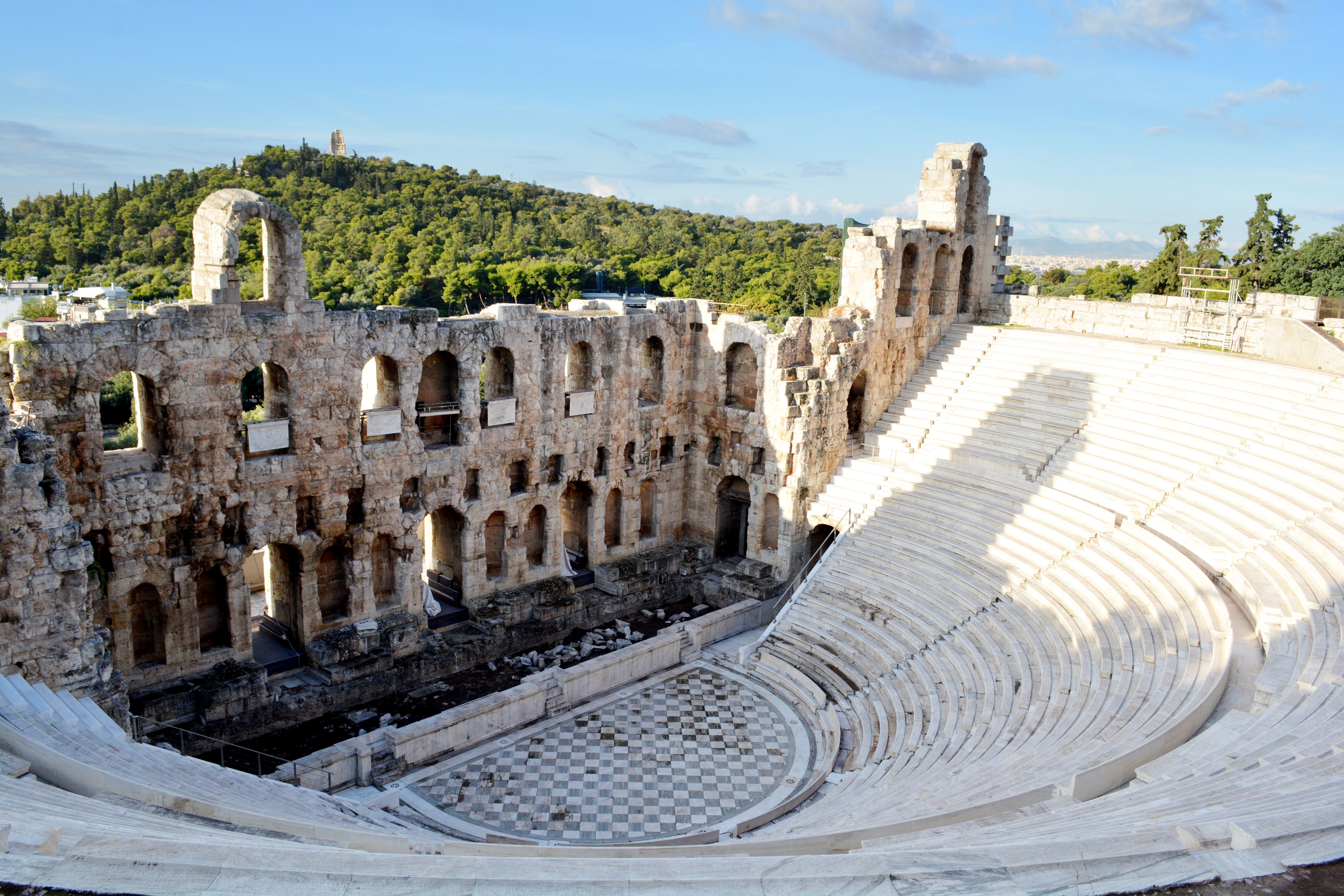
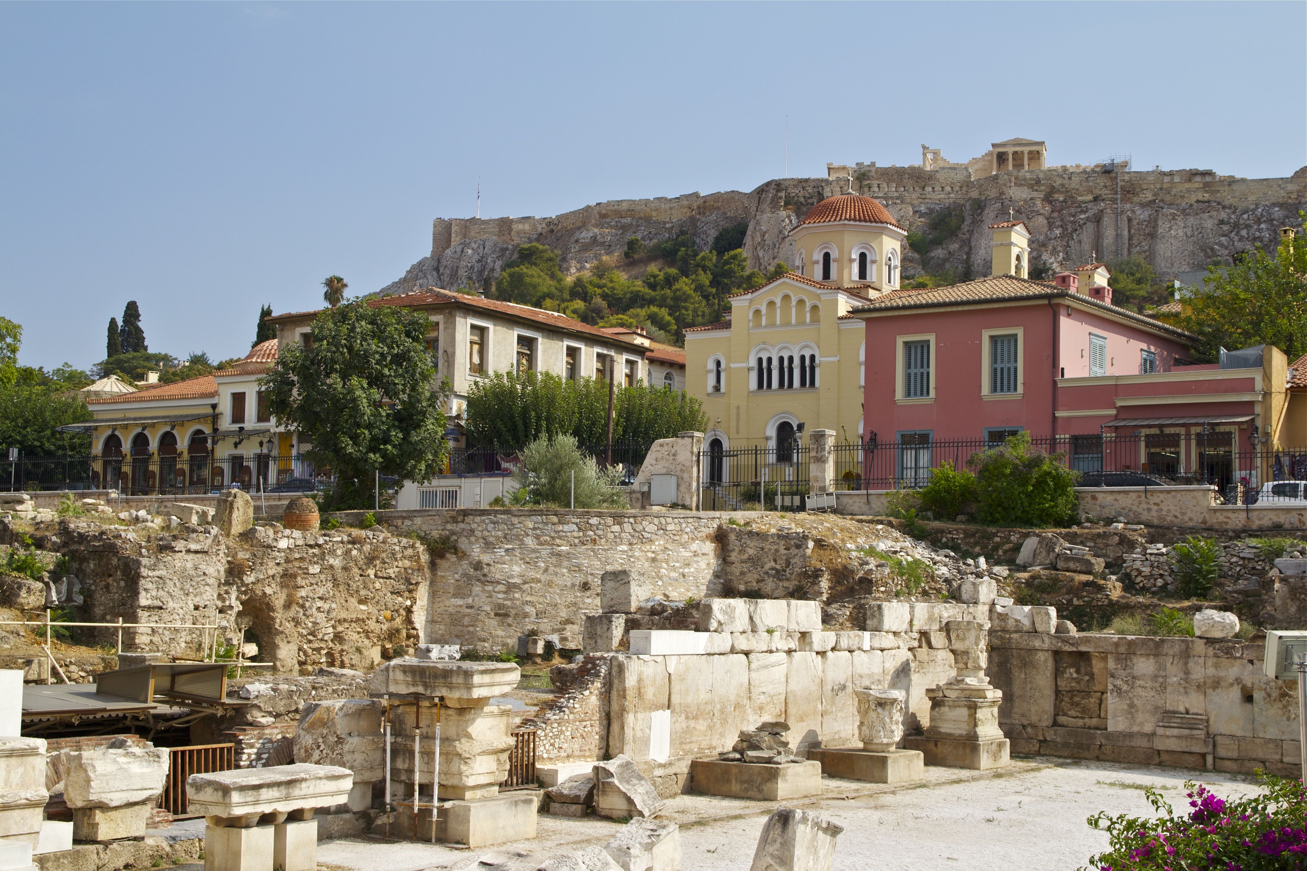
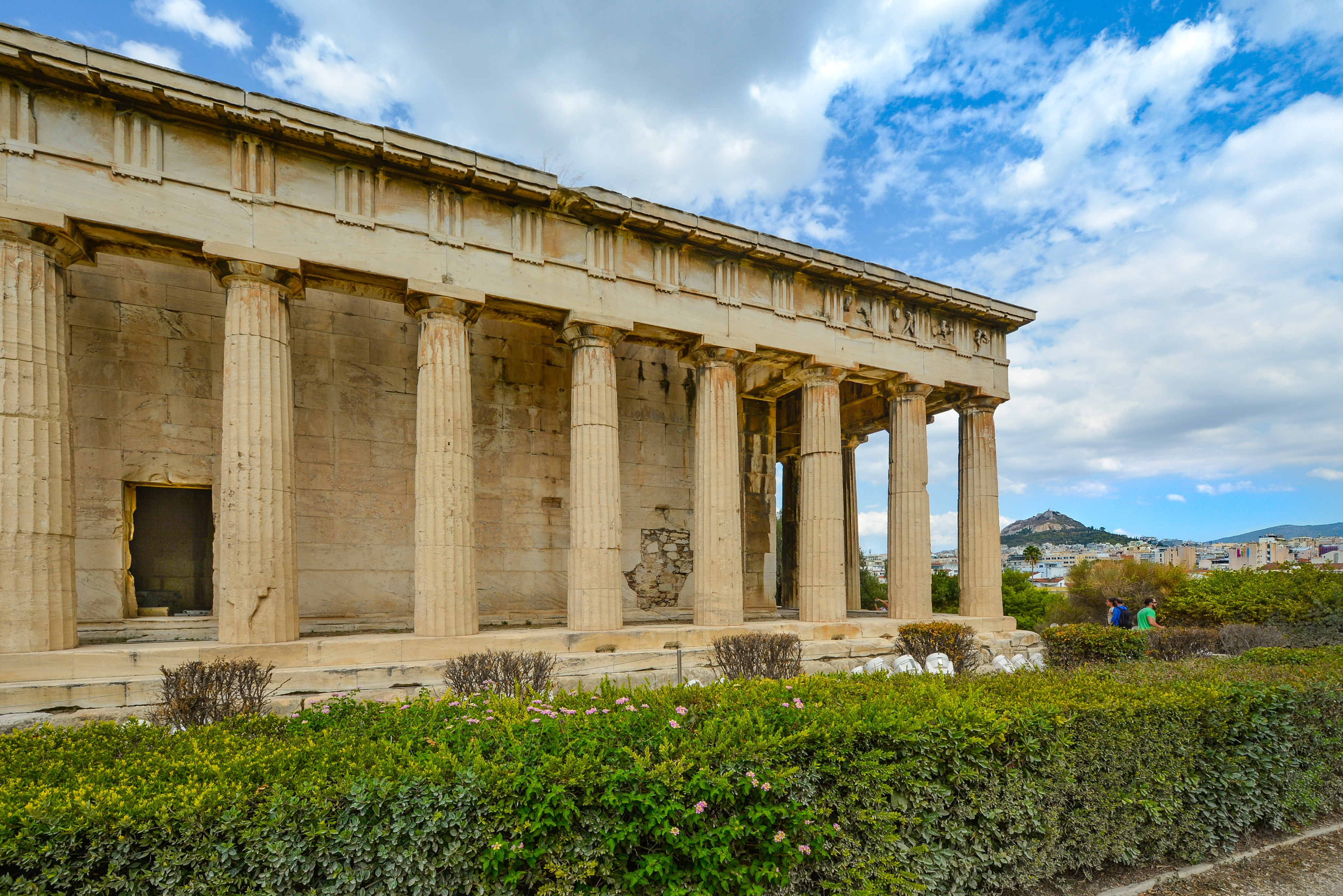
It's no wonder that all roads lead to the fascinating and maddening metropolis of Athens. Lift your eyes 200 feet above the city to the Parthenon, its honey-color marble columns rising from a massive limestone base, and you behold architectural perfection that has not been surpassed in 2,500 years. But, today, this shrine of classical form dominates a 21st-century boomtown. To experience Athens—Athína in Greek—fully is to understand the essence of Greece: ancient monuments surviving in a sea of cement, startling beauty amid the squalor, tradition juxtaposed with modernity. Locals depend on humor and flexibility to deal with the chaos; you should do the same. The rewards are immense. Although Athens covers a huge area, the major landmarks of the ancient Greek, Roman, and Byzantine periods are close to the modern city center. You can easily walk from the Acropolis to many other key sites, taking time to browse in shops and relax in cafés and tavernas along the way. From many quarters of the city you can glimpse "the glory that was Greece" in the form of the Acropolis looming above the horizon, but only by actually climbing that rocky precipice can you feel the impact of the ancient settlement. The Acropolis and Filopappou, two craggy hills sitting side by side; the ancient Agora (marketplace); and Kerameikos, the first cemetery, form the core of ancient and Roman Athens. Along the Unification of Archaeological Sites promenade, you can follow stone-paved, tree-lined walkways from site to site, undisturbed by traffic. Cars have also been banned or reduced in other streets in the historical center. In the National Archaeological Museum, vast numbers of artifacts illustrate the many millennia of Greek civilization; smaller museums such as the Goulandris Museum of Cycladic Art Museum and the Byzantine and Christian Museum illuminate the history of particular regions or periods. Athens may seem like one huge city, but it is really a conglomeration of neighborhoods with distinctive characters. The Eastern influences that prevailed during the 400-year rule of the Ottoman Empire are still evident in Monastiraki, the bazaar area near the foot of the Acropolis. On the northern slope of the Acropolis, stroll through Plaka (if possible by moonlight), an area of tranquil streets lined with renovated mansions, to get the flavor of the 19th-century's gracious lifestyle. The narrow lanes of Anafiotika, a section of Plaka, thread past tiny churches and small, color-washed houses with wooden upper stories, recalling a Cycladic island village. In this maze of winding streets, vestiges of the older city are everywhere: crumbling stairways lined with festive tavernas; dank cellars filled with wine vats; occasionally a court or diminutive garden, enclosed within high walls and filled with magnolia trees and the flaming trumpet-shaped flowers of hibiscus bushes. Formerly run-down old quarters, such as Thission, Gazi and Psirri, popular nightlife areas filled with bars and mezedopoleia (similar to tapas bars), are now in the process of gentrification, although they still retain much of their original charm, as does the colorful produce and meat market on Athinas. The area around Syntagma Square, the tourist hub, and Omonia Square, the commercial heart of the city about 1 km (½ mi) northwest, is distinctly European, having been designed by the court architects of King Otho, a Bavarian, in the 19th century. The chic shops and bistros of ritzy Kolonaki nestle at the foot of Mt. Lycabettus, Athens's highest hill (909 feet). Each of Athens's outlying suburbs has a distinctive character: in the north is wealthy, tree-lined Kifissia, once a summer resort for aristocratic Athenians, and in the south and southeast lie Glyfada, Voula, and Vouliagmeni, with their sandy beaches, seaside bars, and lively summer nightlife. Just beyond the city's southern fringes is Piraeus, a bustling port city of waterside fish tavernas and Saronic Gulf views.

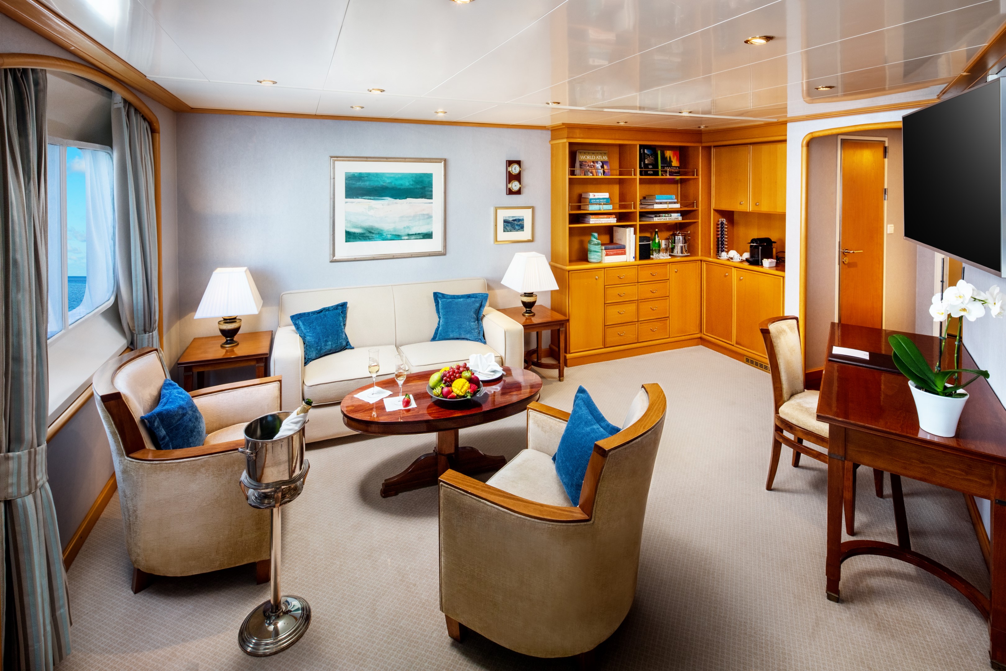
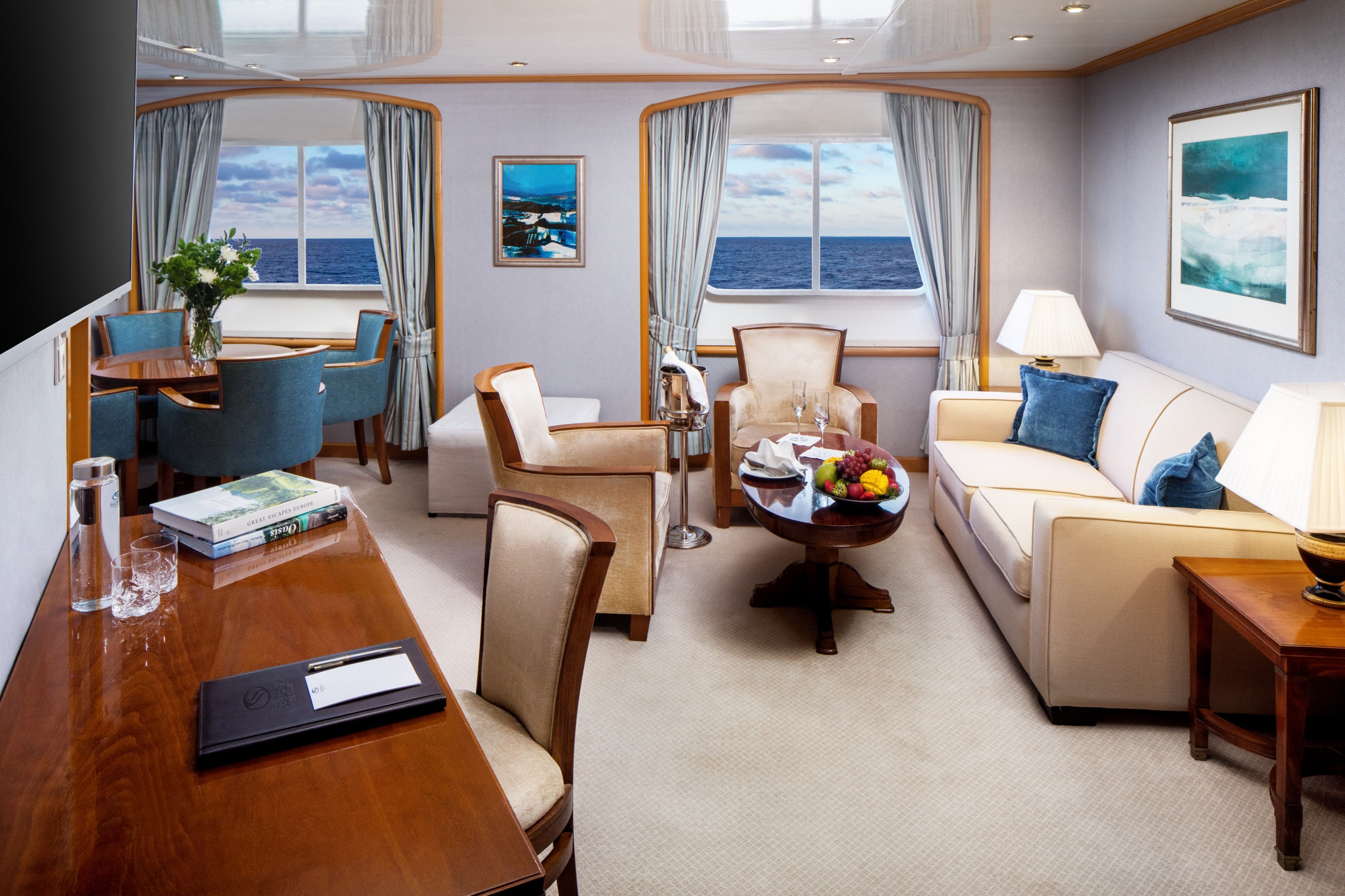
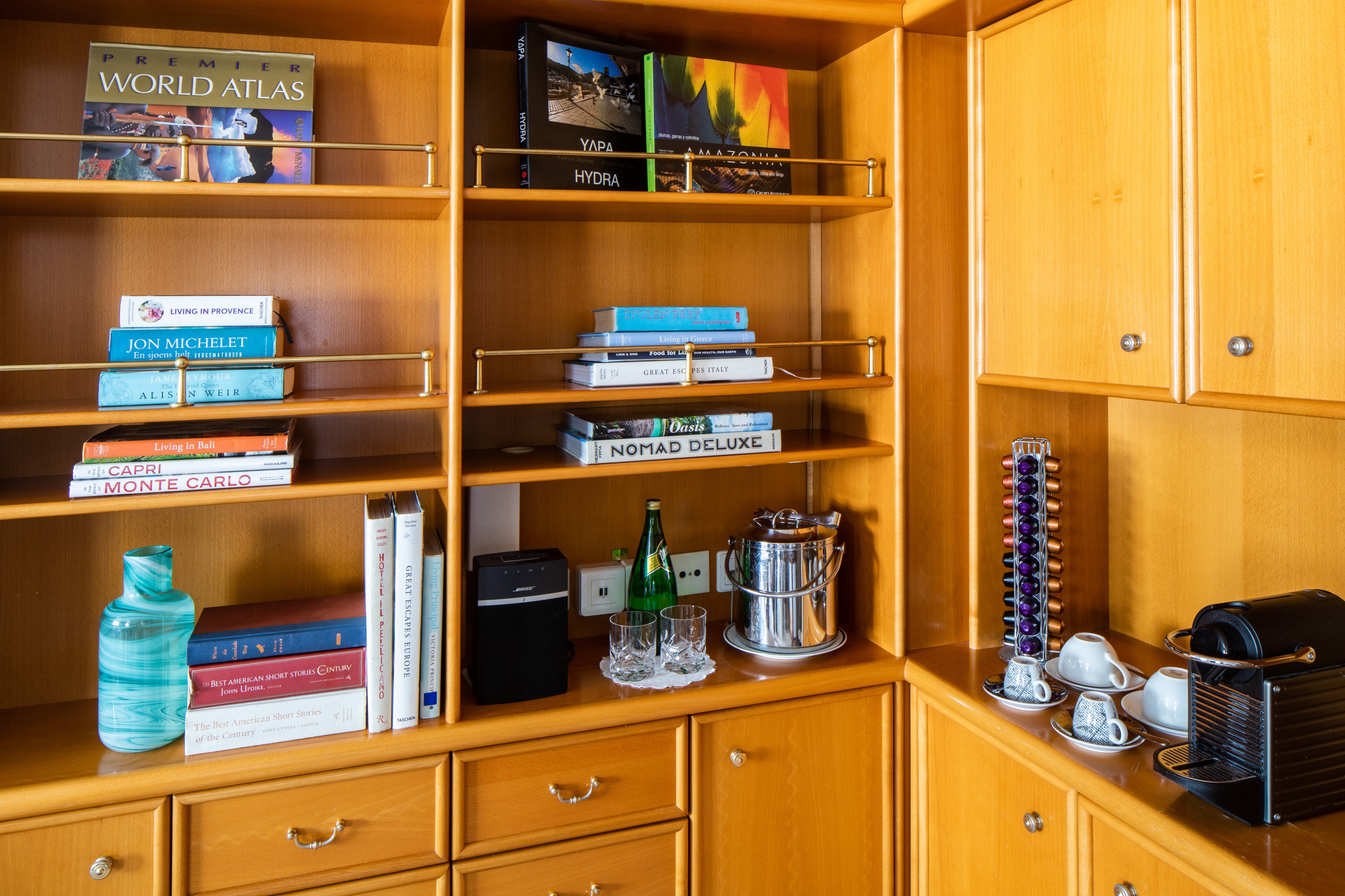
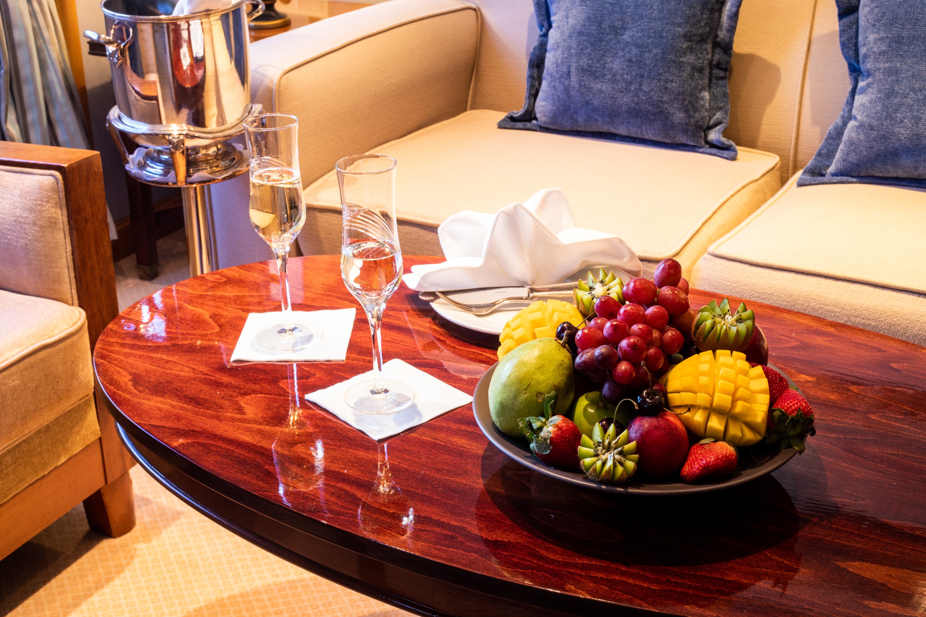
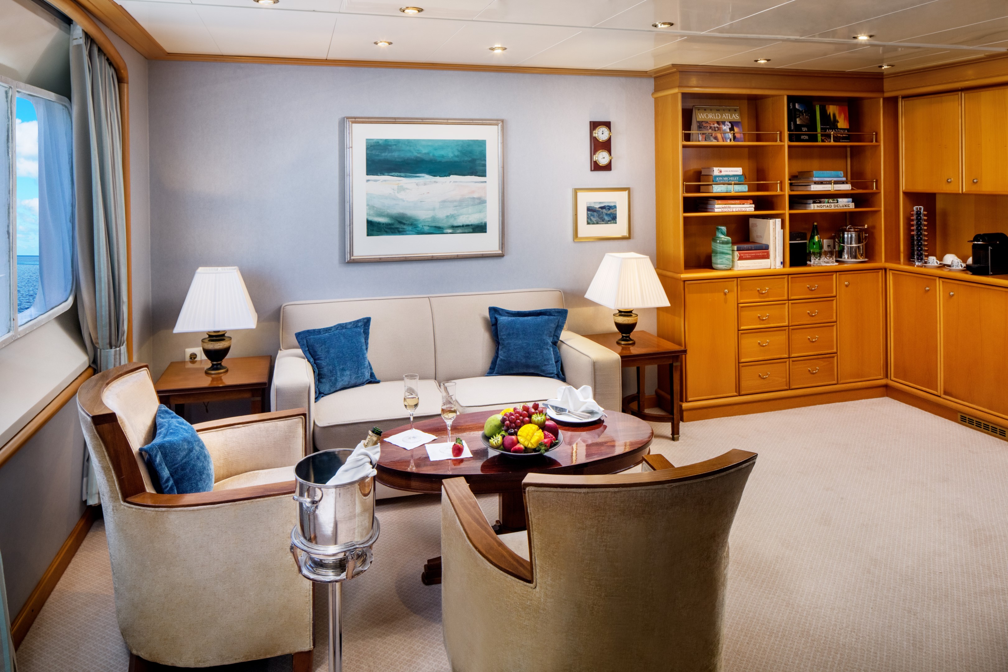
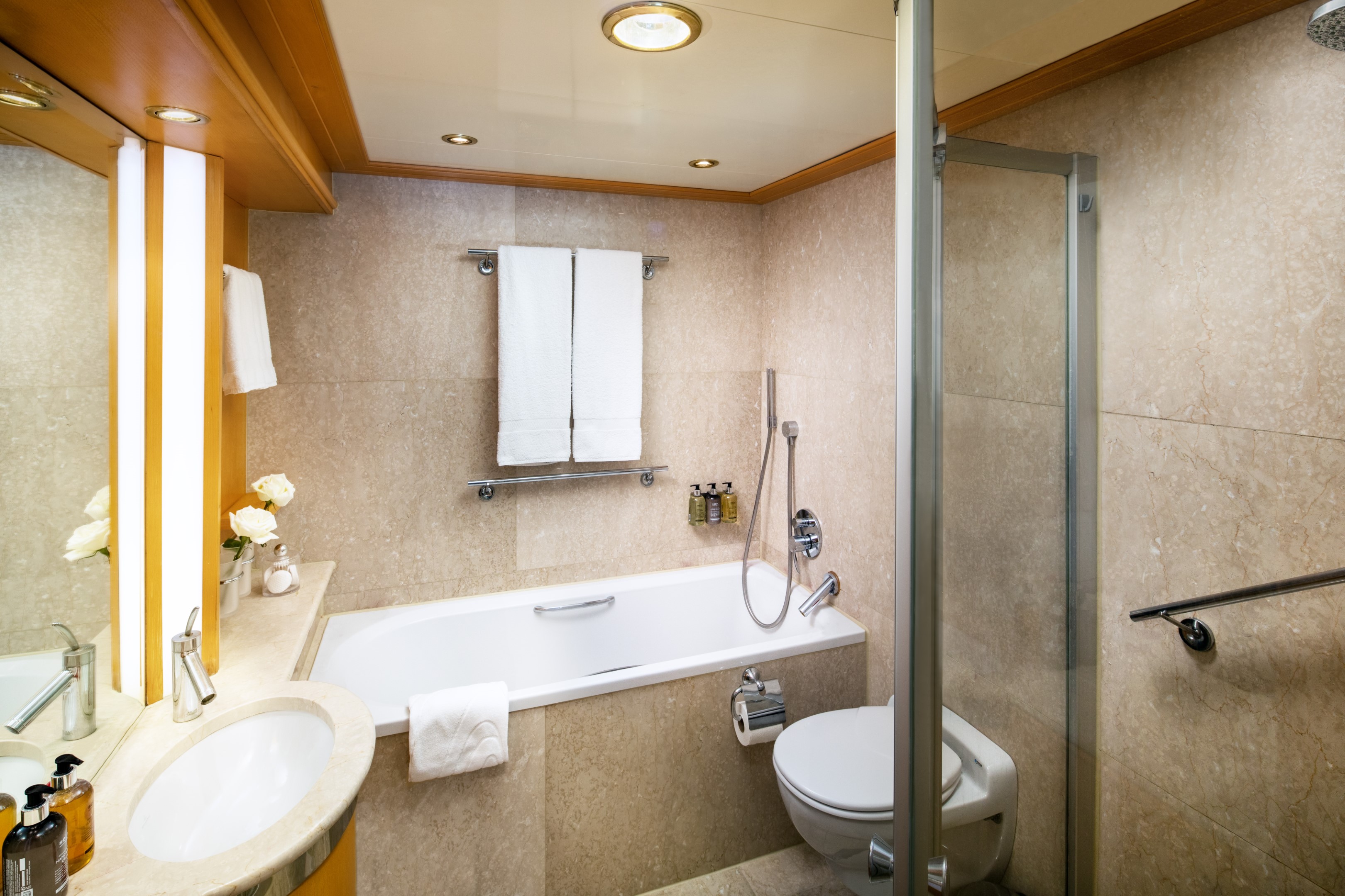
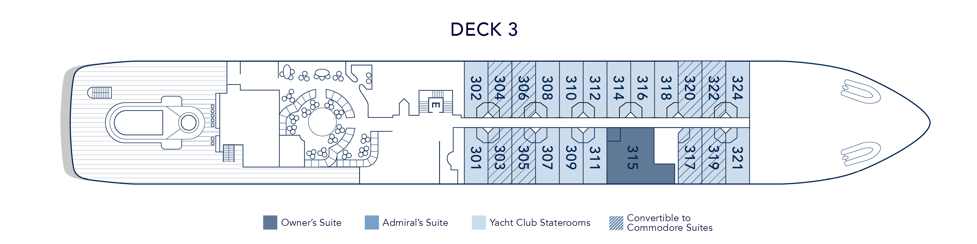
At 447 square feet, the Owner’s Suite is the largest and most considered accommodation on the yacht. A separate master bedroom with a permanent queen bed opens to a spacious living and dining area, generous enough to host family and friends in comfort, while the marble bathroom offers both a massage shower and a soaking tub with uninterrupted views of the sea. A half guest bath, writing desk, and Nespresso machine complete a suite designed for those who want the full breadth of the SeaDream experience, in a space entirely their own.
Suite 315, located mid-ship on Deck 3, just steps from the pool.
Owner’s Suite Additional Amenities:
- 55" flat-screen TVs
- Belgian linens
- Silk clothes hangers
- Direct-dial telephone
- 24-hour small bites
- Nespresso machine
- Luxury robes & slippers
- Make-up mirror
- Wi-Fi Available
- Climate control
- Beverage refrigerator
- Elm Organics bath amenities
- Hair dryer
- In-room safe
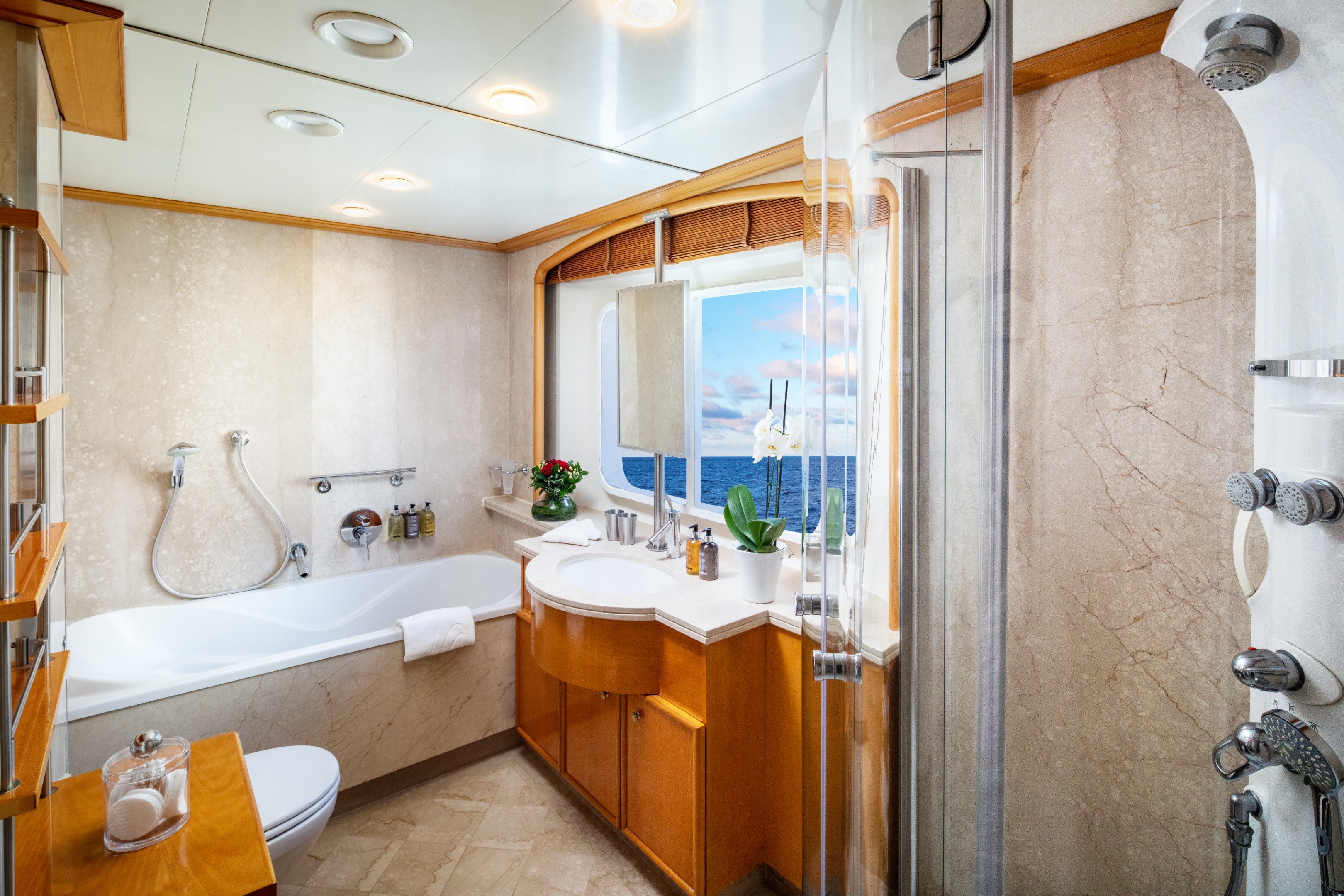
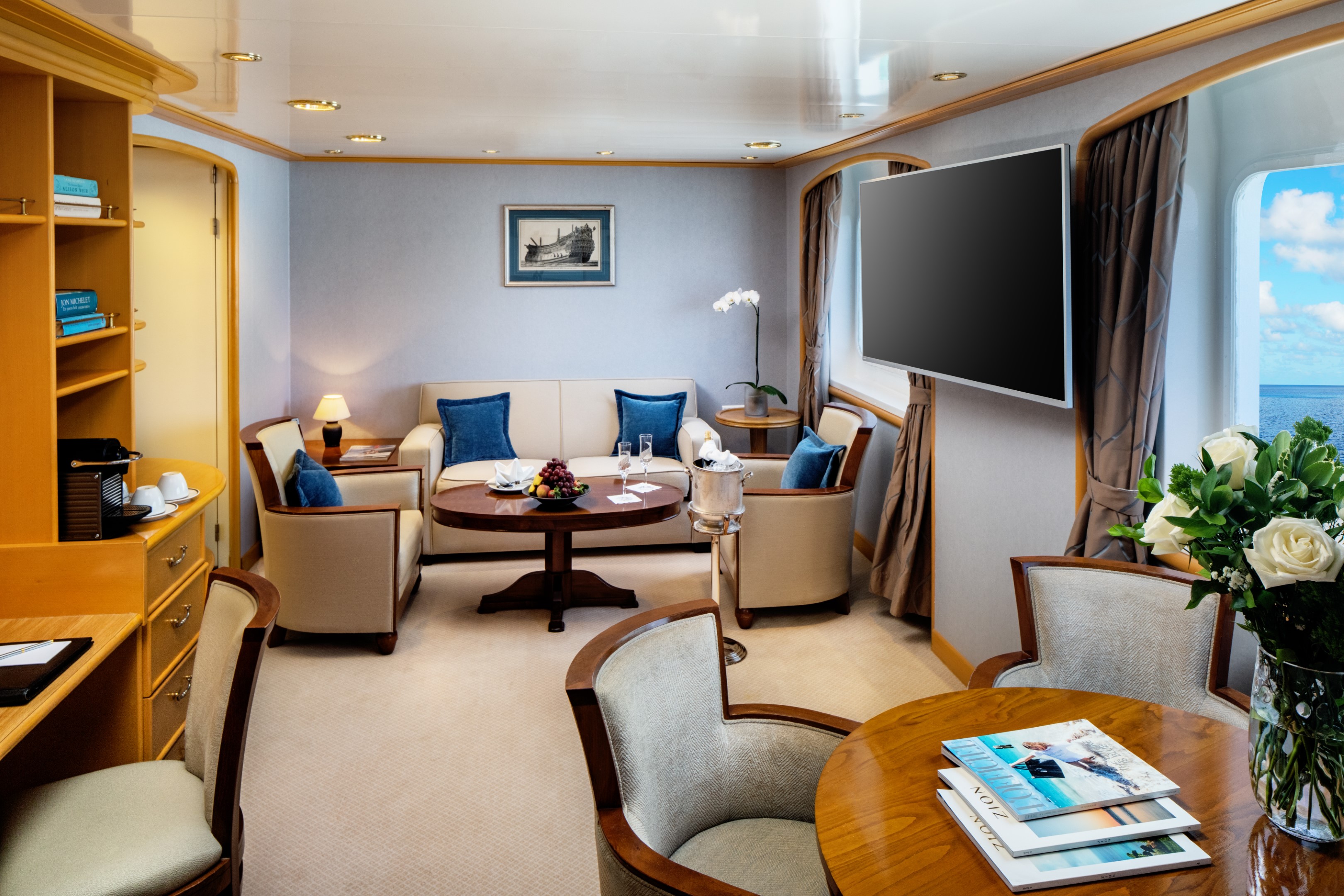
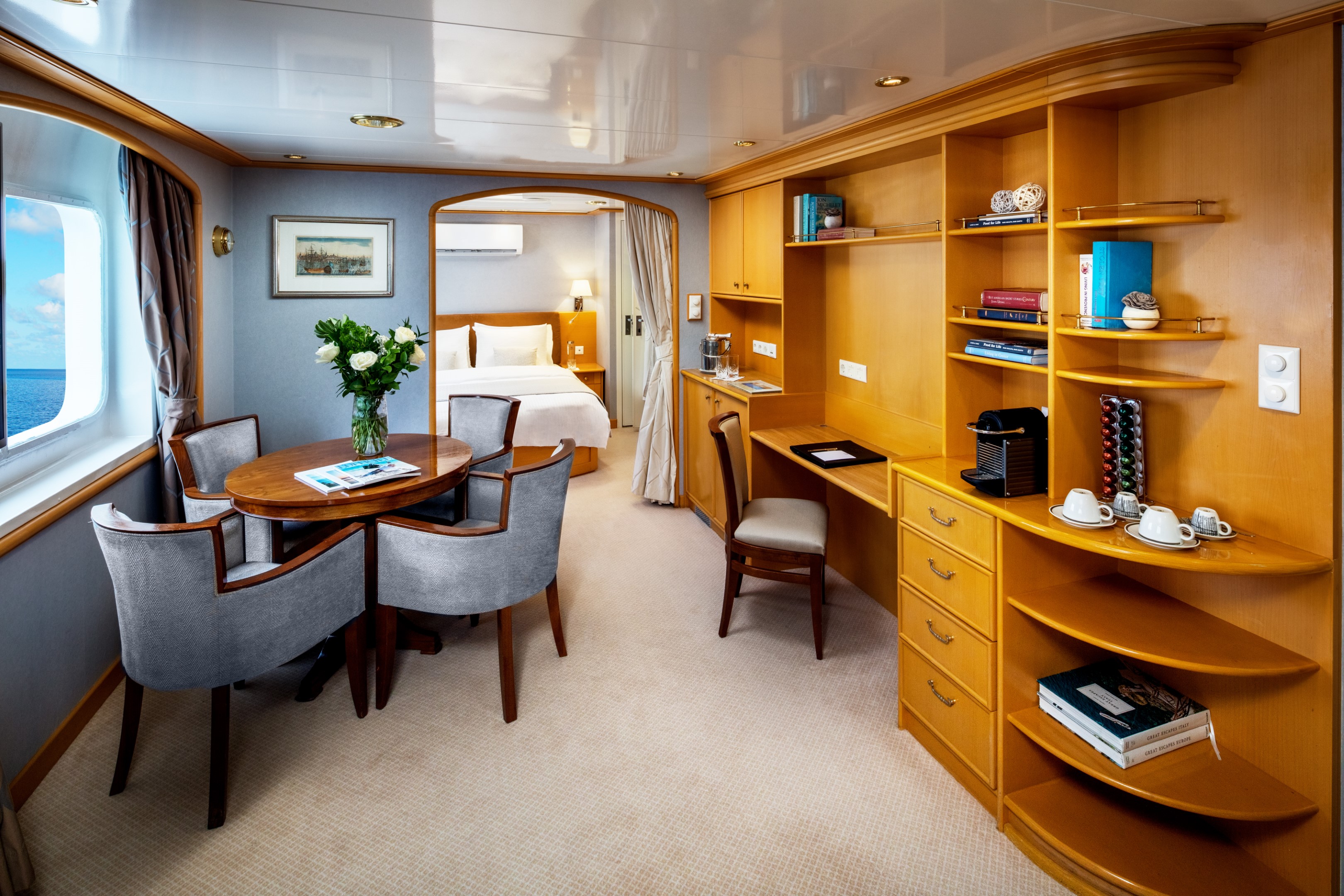
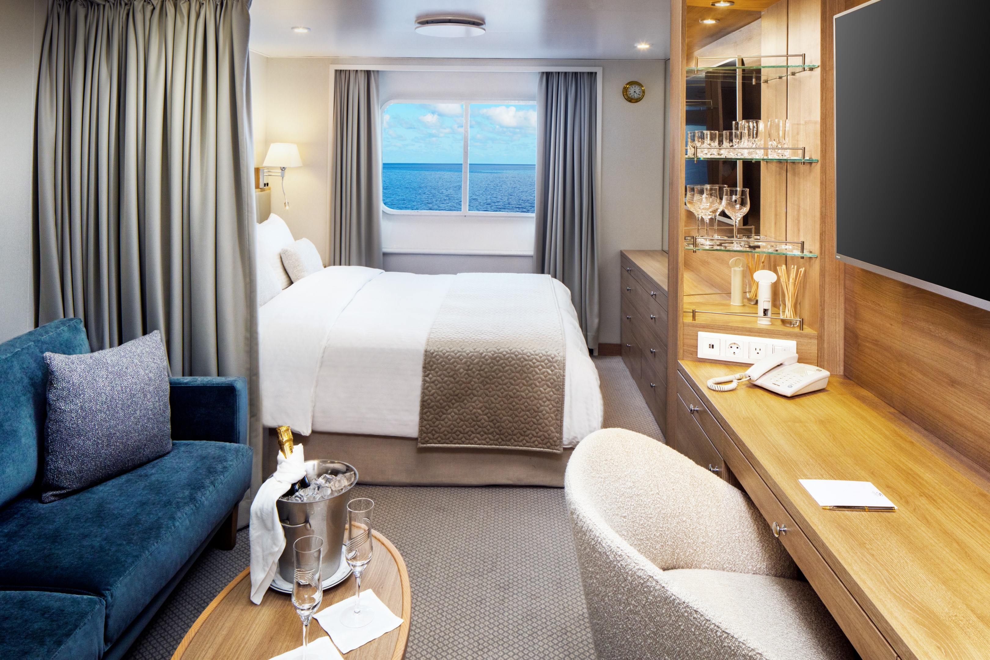
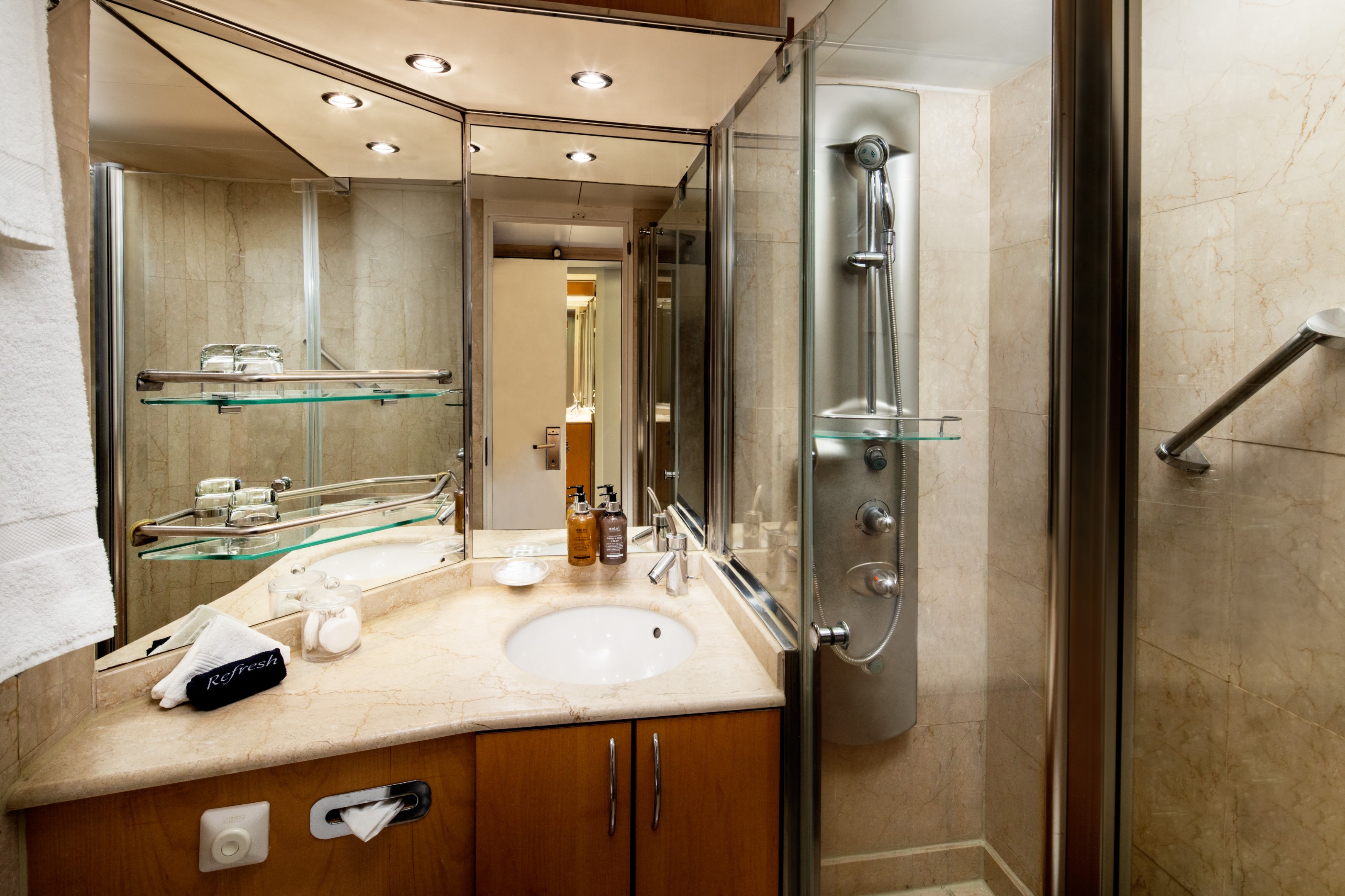
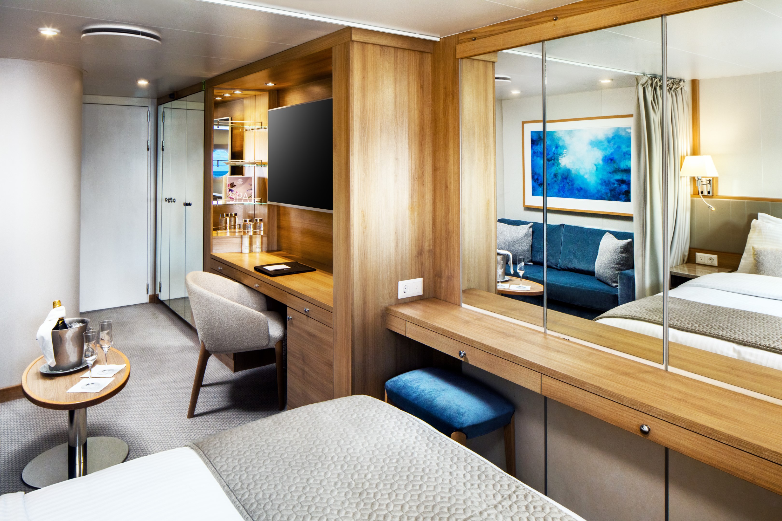
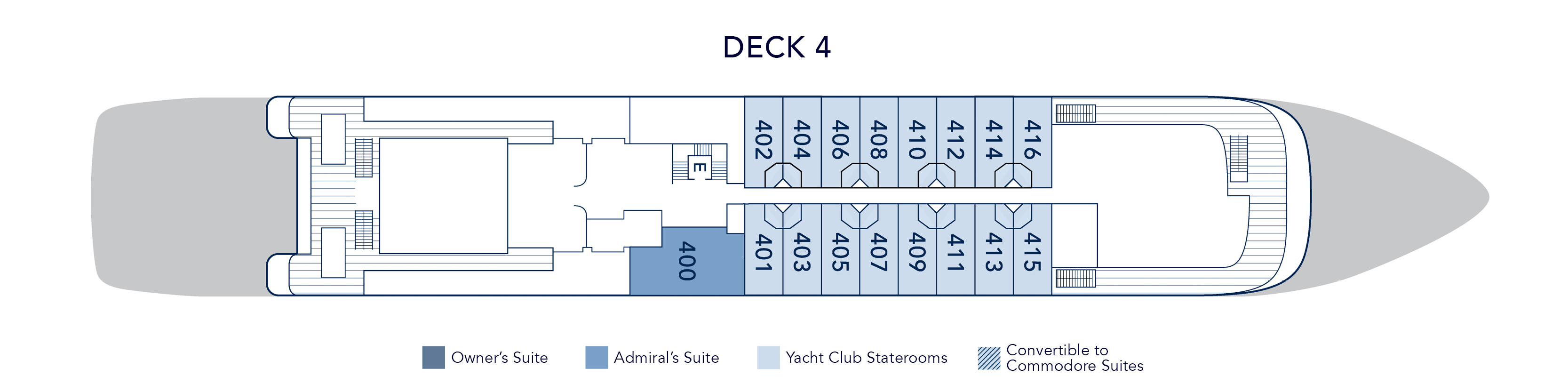
At 375 square feet, the Admiral’s Suite is a luminous retreat at sea. Three picture windows frame the ocean from every angle, filling the partitioned living and dining area with natural light throughout the day. A separate master bedroom with a permanent queen bed offers privacy and quiet, while the marble bathroom draws you in with both a soaking tub and a multi-jet shower. A half guest bath, built-in dresser, and writing desk round out a suite that balances elegance with ease.
Suite 400 on both yachts, located on Deck 4 near the Library.
Admiral’s Suite Additional Amenities:
- 55" flat-screen TVs
- Belgian linens
- Silk clothes hangers
- Direct-dial telephone
- 24-hour small bites
- Nespresso machine
- Luxury robes & slippers
- Make-up mirror
- Wi-Fi Available
- Climate control
- Beverage refrigerator
- Elm Organics bath amenities
- Hair dryer
- In-room safe
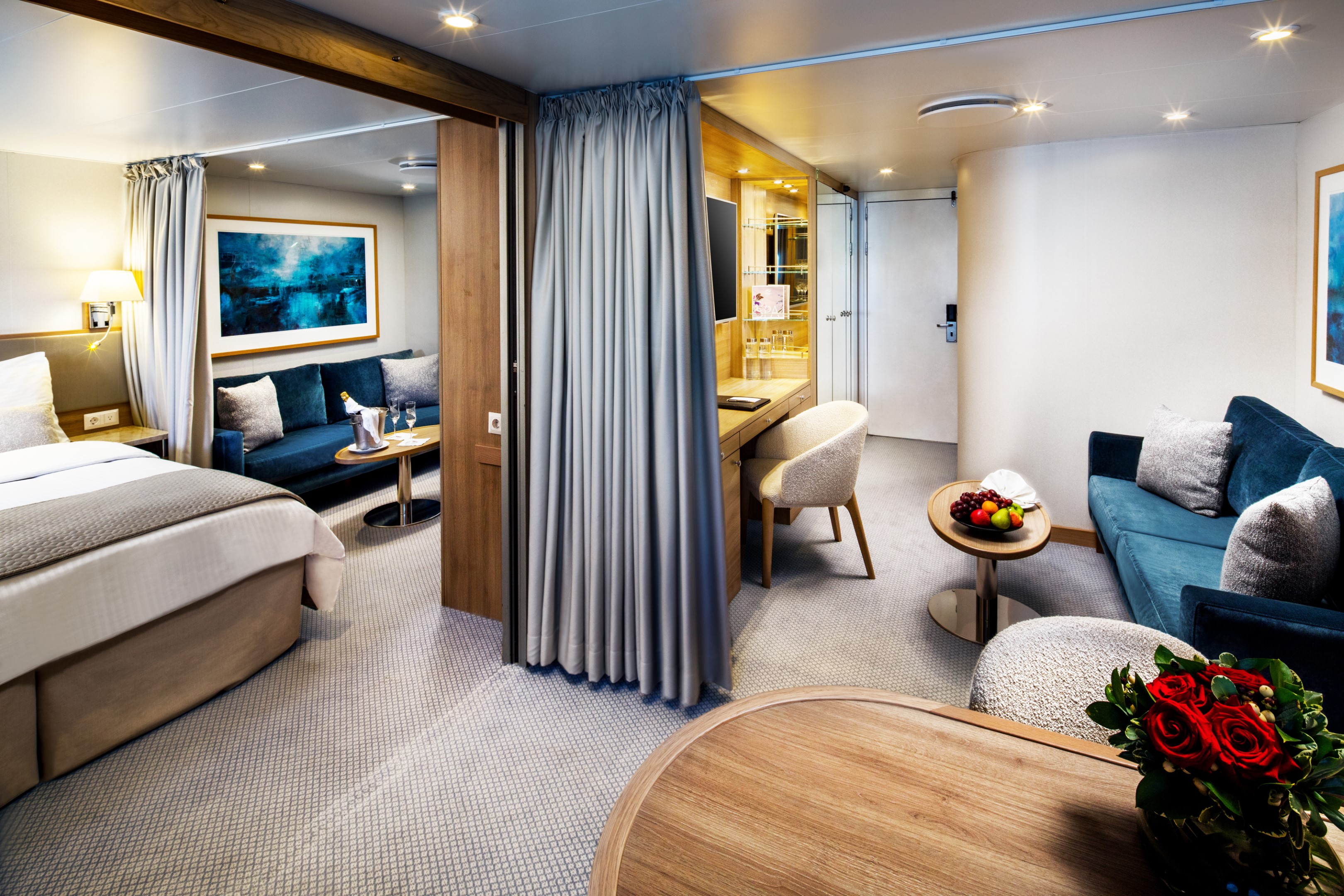
The Commodore Suite brings two Yacht Club Staterooms together into one beautifully considered space averaging 390 square feet. The result is a suite that feels genuinely spacious and luxurious. Two full marble bathrooms with multi-jet showers, a seating area with sofa and cocktail table, two spacious closets, and a built-in dresser with writing desk. Choose between twin beds or a queen and configure the second space as a dining area or additional queen bed, depending on how you want to use it.
Eight Commodore Suites are available across the yacht, with Deck 2 suites featuring four 17” round porthole windows and Deck 3 suites offering picture windows, steps from the pool and Main Salon.
Commodore Suite Additional Amenities:
- 55" flat-screen TVs
- Belgian linens
- Silk clothes hangers
- Direct-dial telephone
- 24-hour small bites
- Luxury robes & slippers
- Make-up mirror
- Wi-Fi Available
- Climate control
- Beverage refrigerator
- Elm Organics bath amenities
- Hair dryer
- In-room safe
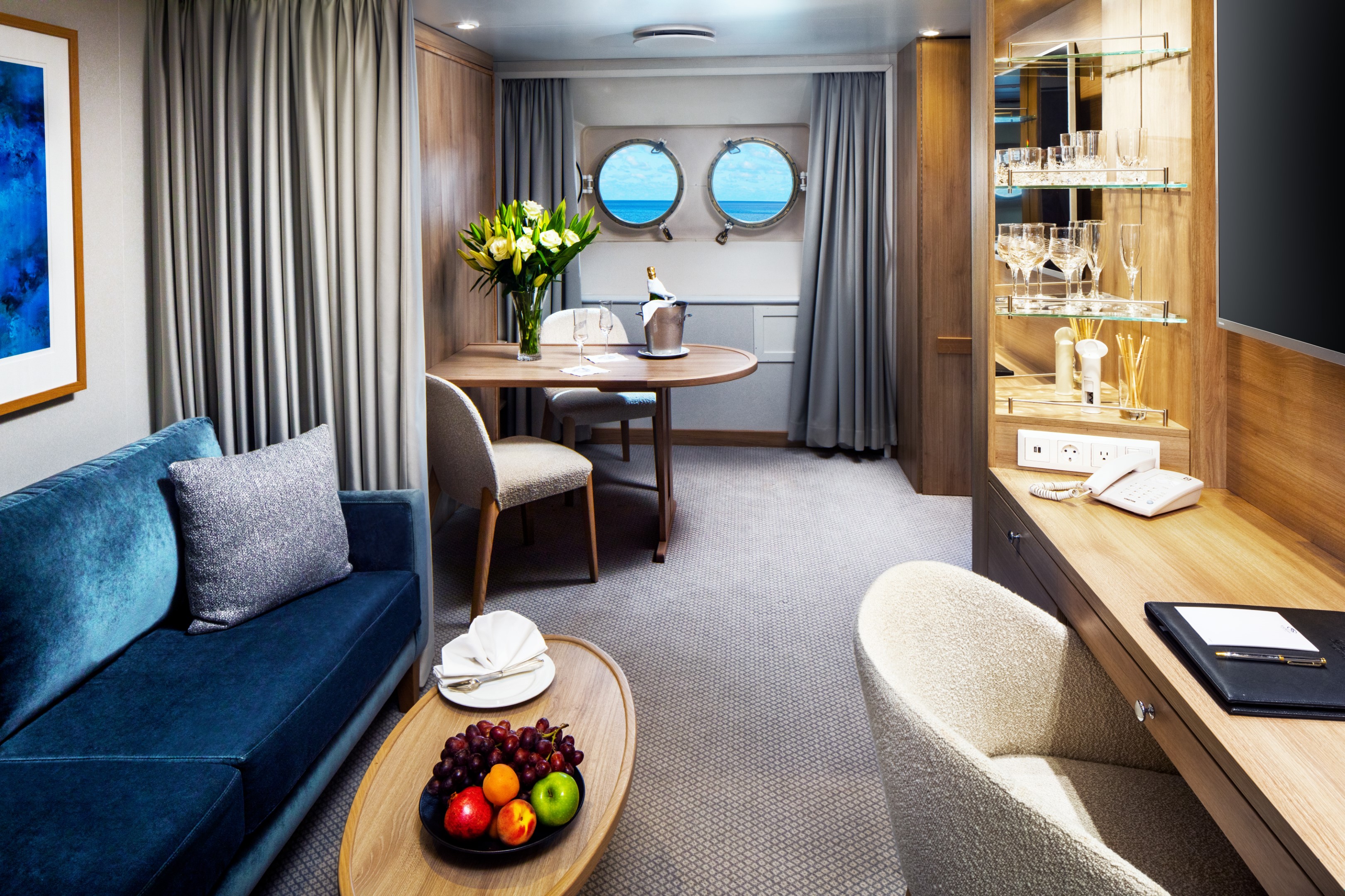
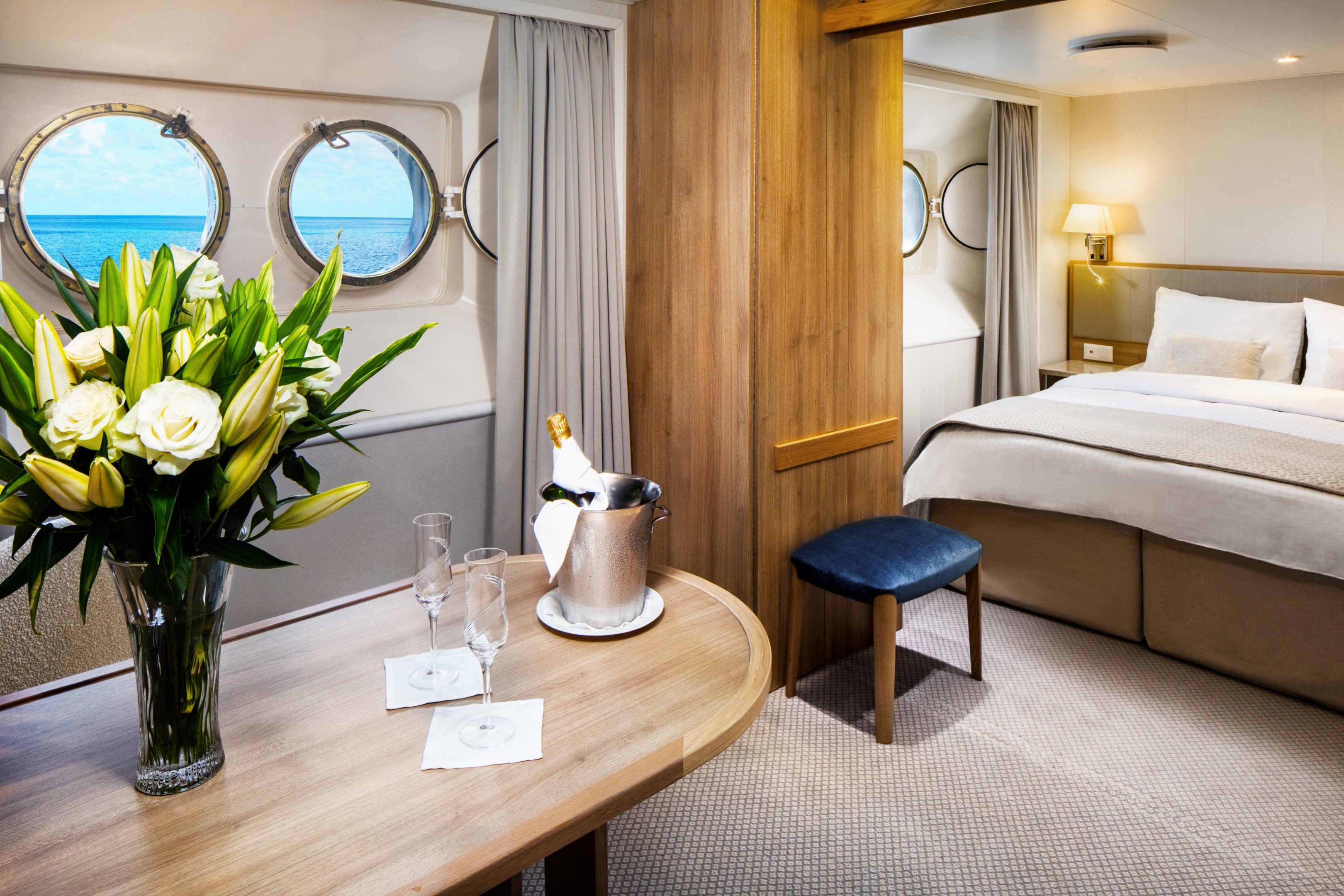
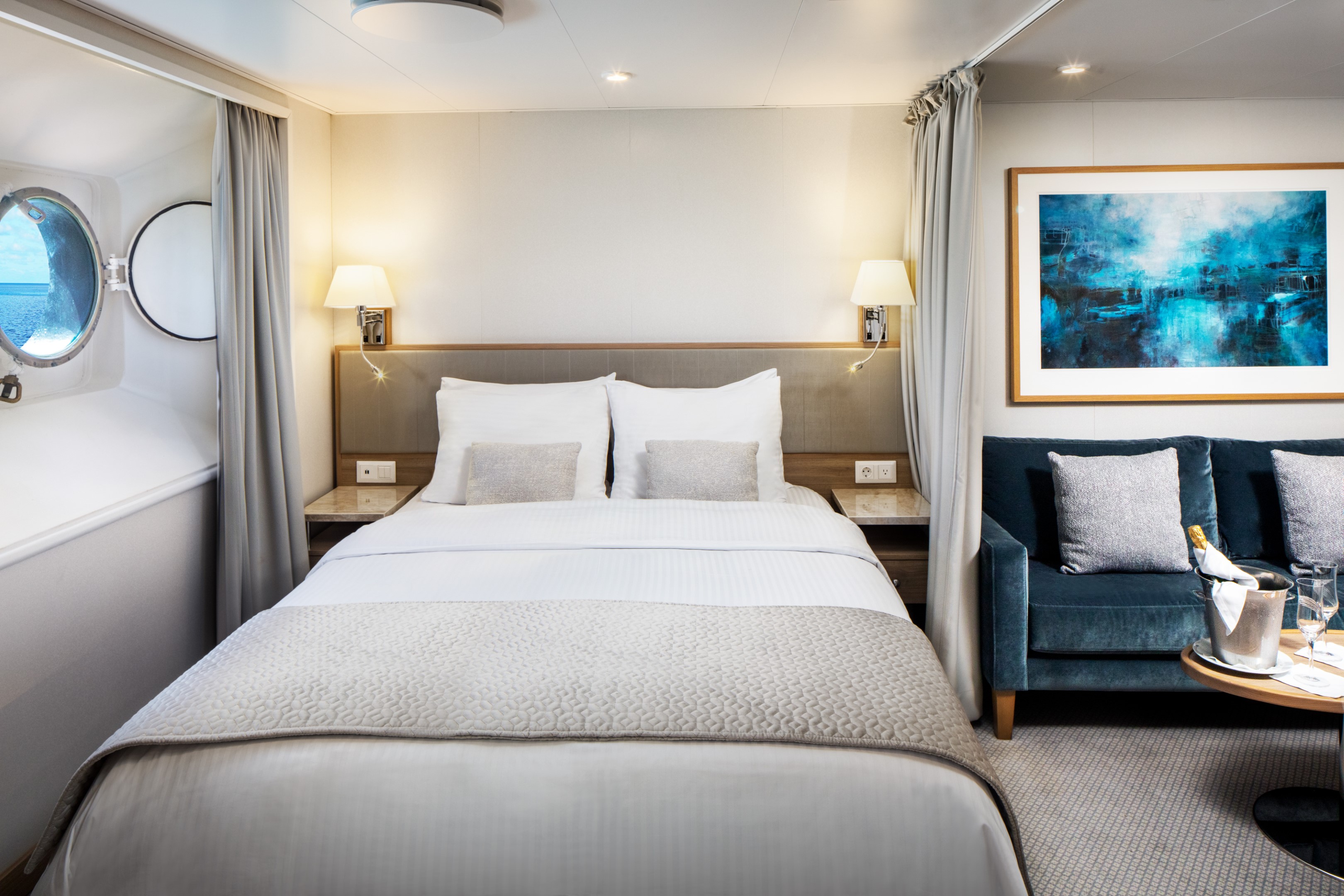
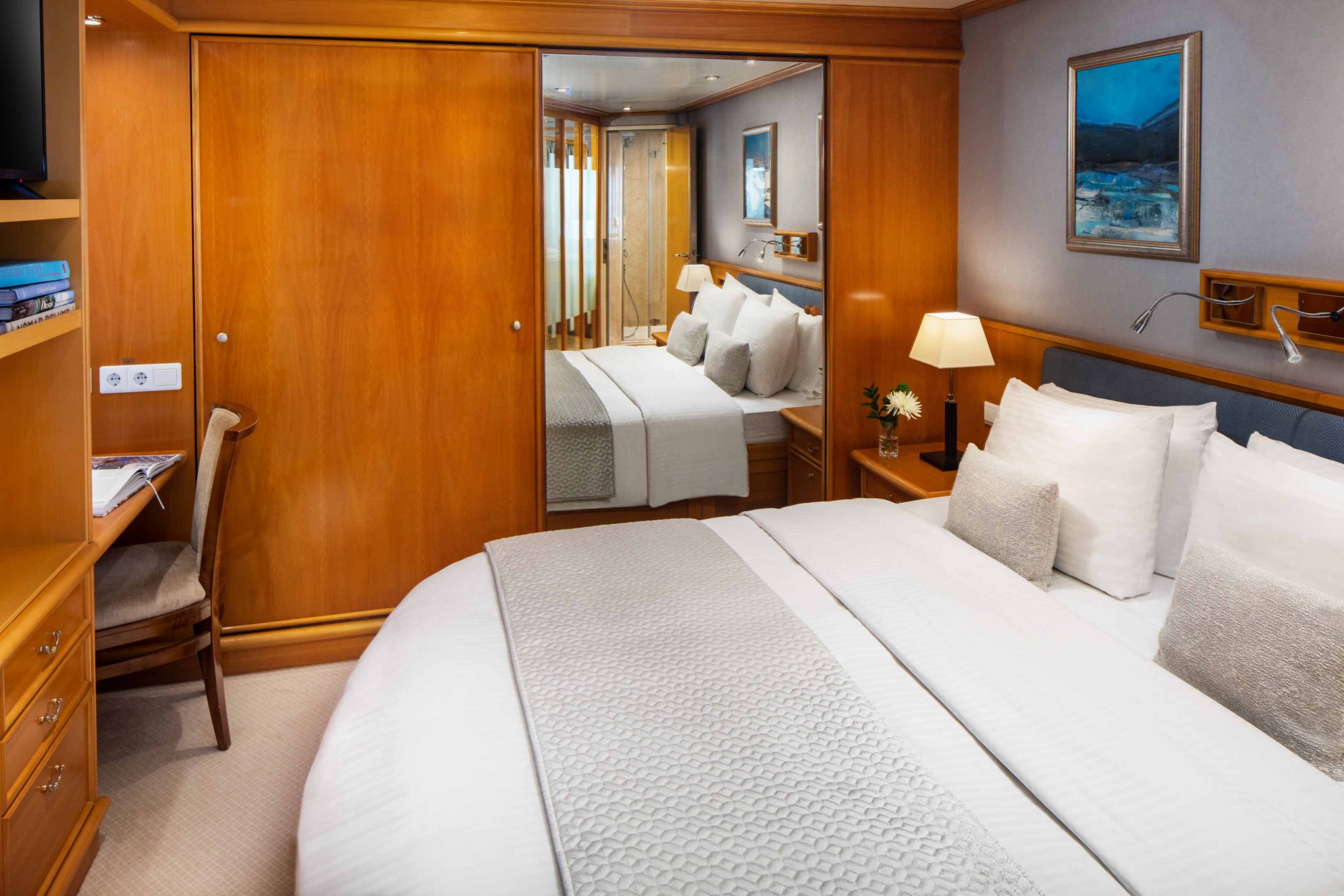
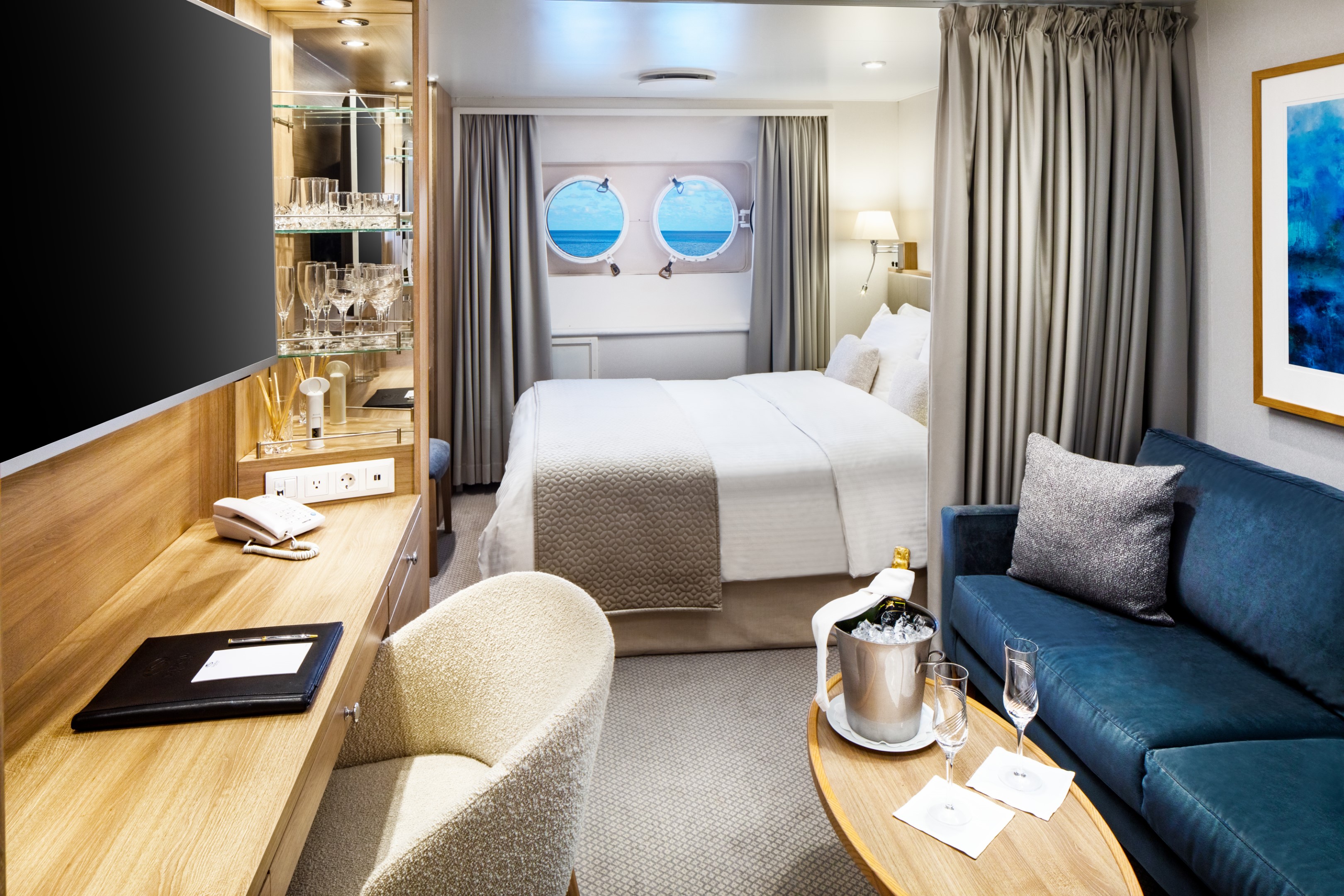
Averaging 195 square feet, the Yacht Club Stateroom is where the yachting lifestyle truly comes to life. Picture windows frame the open sea, while a marble-lined bathroom with a multi-jet shower and well-appointed living area with sofa, cocktail table, and writing desk offer every comfort you need. Choose between twin beds or a queen and settle into a space that feels considered from every angle.
Deck 3 staterooms sit just steps from the pool, while Deck 4 places you close to the SeaDream Spa, Fitness Center and Library.
Yacht Club Stateroom Additional Amenities:
- 55" flat-screen TVs
- Belgian linens
- Silk clothes hangers
- Direct-dial telephone
- 24-hour small bites
- Luxury robes & slippers
- Make-up mirror
- Wi-Fi Available
- Climate control
- Beverage refrigerator
- Elm Organics bath amenities
- Hair dryer
- In-room safe
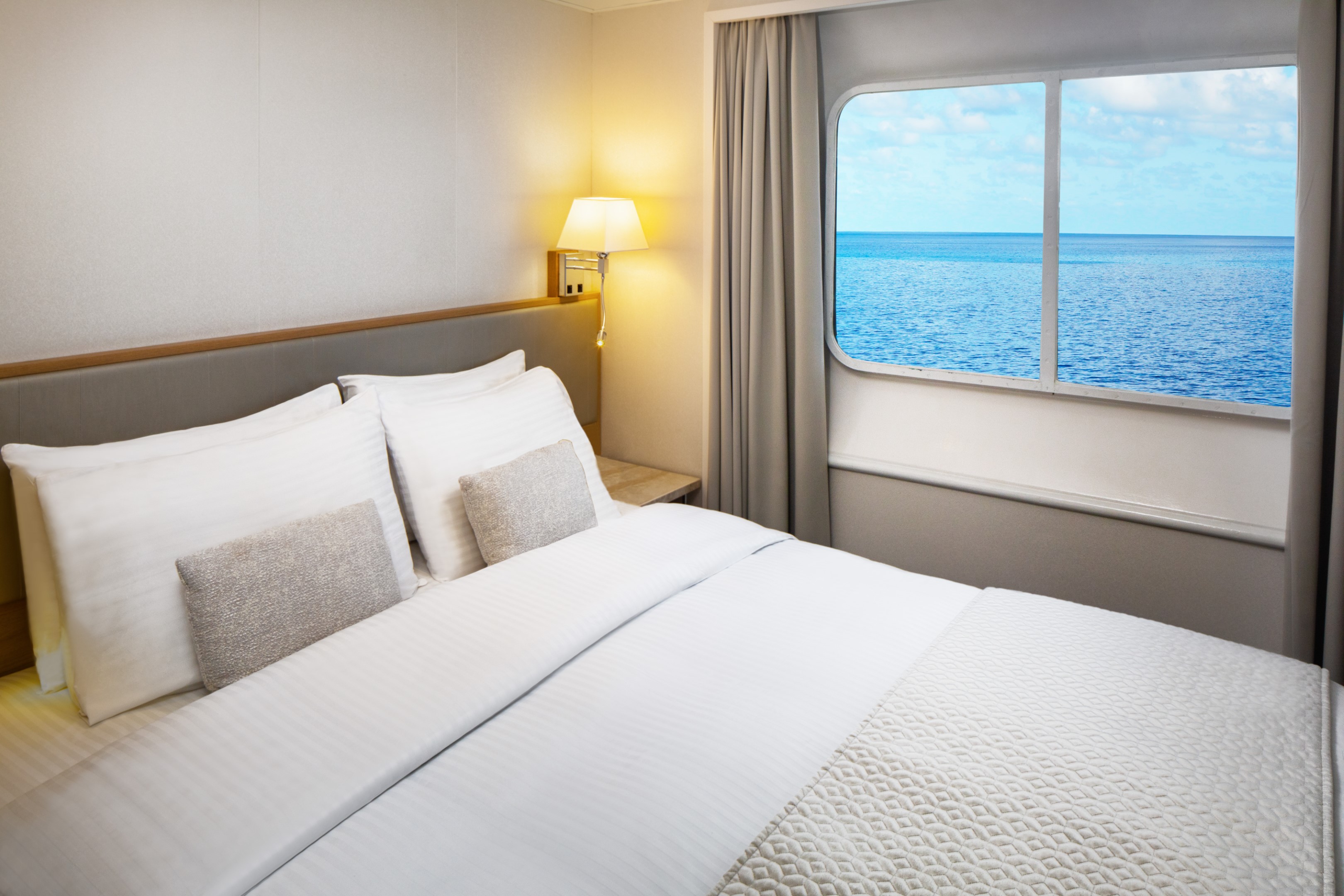
The Yacht Club Staterooms on Deck 2 offer 195 square feet of refined comfort at sea. Two round porthole windows bring the ocean into the room in a way that feels intimate and unhurried. A marble-lined bathroom with a multi-jet shower, an open living area with sofa, cocktail table, and writing desk, and ample closet space complete with a stateroom that is quietly, thoroughly considered.
Yacht Club Stateroom Additional Amenities:
- 55" flat-screen TVs
- Belgian linens
- Silk clothes hangers
- Direct-dial telephone
- 24-hour small bites
- Luxury robes & slippers
- Make-up mirror
- Wi-Fi Available
- Climate control
- Beverage refrigerator
- Elm Organics bath amenities
- Hair dryer
- In-room safe
SeaDream II
With 95 crew members looking after just 112 guests across 56 staterooms and suites, the level of service aboard these intimate boutique ships is unlike anything else at sea. Every stateroom and suite faces the sea, each offering luxury accommodations designed around the yachting lifestyle. As an all-inclusive luxury yacht, everything from the open bar to gratuities is taken care of. This is what yachting feels like.
Luxury Suites & Staterooms
Aboard SeaDream, every stateroom and suite is a private luxury retreat designed around the sea. Queen-size beds, marble bathrooms, and uninterrupted ocean views come with every room. For those seeking even more space, the Owner's Suite and Admiral’s Suite offer soaking tubs and generous living areas perfect for entertaining friends and family.
The Onboard Experience
Life aboard SeaDream is defined by elegant informality. Mornings might begin with yoga on deck as the coastline drifts past. Afternoons open to watersports at sea from the Marina, a massage at the spa, or simply a Balinese Bed and the horizon. Evenings bring world-class cuisine under the stars. It feels less like a small ship cruise and more like a private yacht charter.
Among boutique cruise lines, SeaDream stands apart. A luxury yachting vacation built around an intimate setting, ultra luxury service, and a crew that knows your name. Year after year, the world's most trusted travel publications return to SeaDream. The Condé Nast Traveler Gold List, Travel + Leisure, and Cruise Critic have each recognized what guests already know.

Ship Facts
| Launch Year | 1985 | ||||||||
| Refit Year | 2022 | ||||||||
| Language | en | ||||||||
| Gross Tonnage | 4300 | ||||||||
| Length | 105 | ||||||||
| Width | 14 | ||||||||
| Currency | USD | ||||||||
| Speed | 18 | ||||||||
| Capacity | 112 | ||||||||
| Crew Count | 95 | ||||||||
| Deck Count | 5 | ||||||||
| Cabin Count | 56 | ||||||||
| Large Cabin Count | 0 | ||||||||
| Wheelchair Cabin Count | 0 | ||||||||
| Electrical Plugs |
|
Deck 6
- Balinese Dream Beds
- Top Of The Yacht Bar
- Golf Simulator
- Sun Deck & Sun Beds
- Couples Hot Tubs
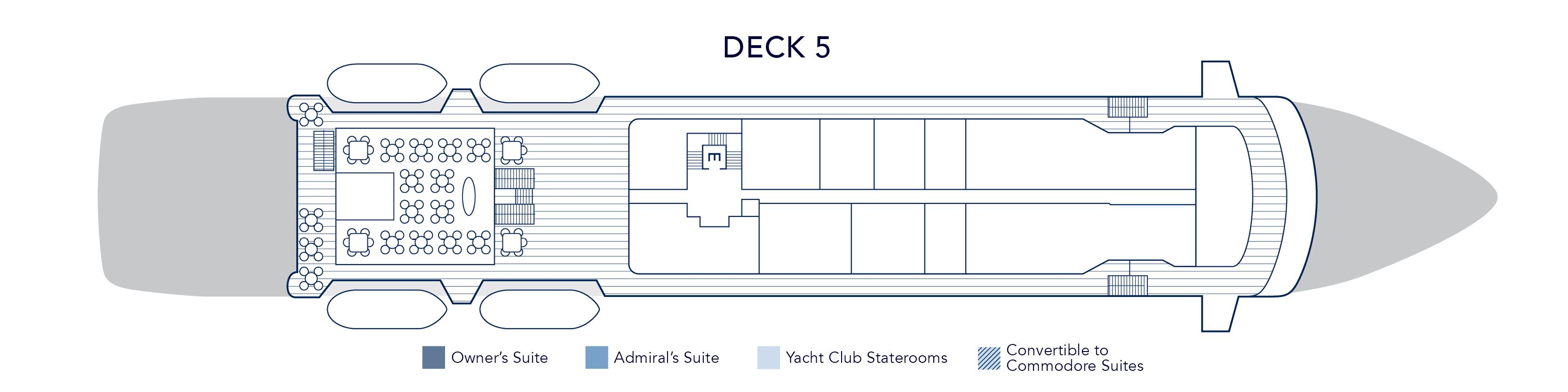
Deck 5
- Topside Restaurant
- Medical Facility
- Open Promenade
- Elevator
- Bridge
Deck 4
- Al Fresco Dining & Lounging
- Library
- Piano Bar
- Casino
- Admiral Suite
- SeaDream Spa
- Fitness Centre
- Beauty Salon
- Elevator
- Yacht Club Staterooms
- Admiral Suite
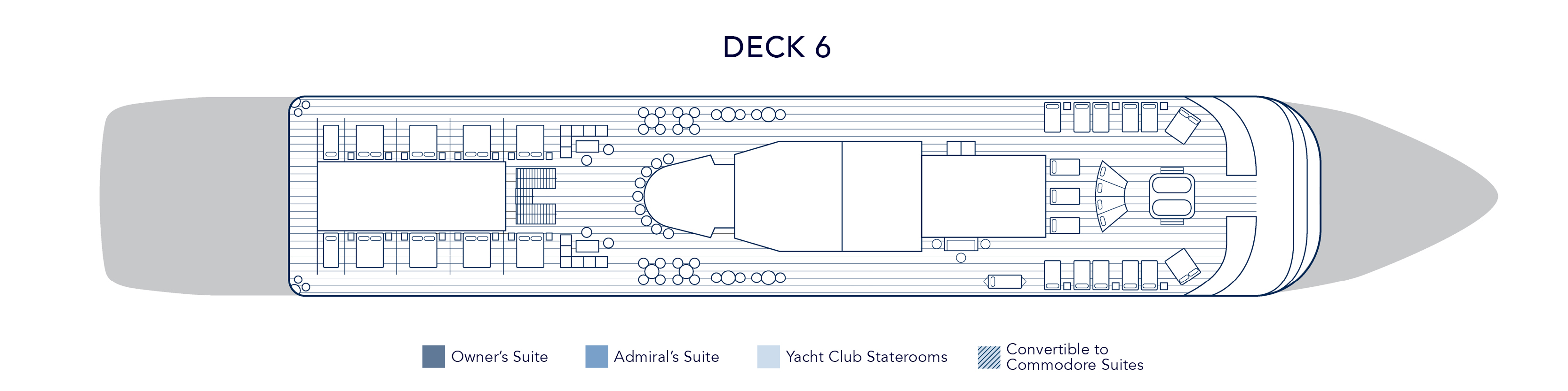
Deck 3
- Pool / Hot Tub
- Pool Bar
- Card Room
- Main Salon / Main Salon Bar
- Concierge & Boutique
- Yacht Club Staterooms
- Commodore Suites
- Owner's Suite
Deck 2
- Retractable Water Sports Platform Marina
- Dining Salon
- Yacht Club Staterooms
- Commodore Suites
Award-Winning Cuisine
Embark on a sensory adventure with our international menus, crafted with the freshest, high-quality ingredients, infused with local flavors, often locally sourced by our chefs. Always included, every dish is prepared à la minute and served al fresco or in our elegant Dining Salon, offering a dining experience that is uniquely yours.
Topside Restaurant
Multi-course menus are prepared à la minute and shaped by the destinations visited. Seasonal ingredients and regional flavors guide each service, delivering gourmet dining experiences available at sea with the standards expected of gourmet dining restaurants known for their excellent wine selection and Michelin-inspired cuisine. Inclusive wine pairing accompanies each dinner, thoughtfully chosen to complement the menu without overpowering it.
From luxury breakfast experiences on deck to candlelit evenings under the stars, the yacht dining experience becomes both a culinary journey and a defining part of life aboard.
Dining Salon
On SeaDream, an exclusive yacht dining experience unfolds with freedom, balance, and quiet refinement. Every breakfast, lunch, and dinner may be enjoyed al fresco beneath open sky or within the elegant dining salon, creating a seamless expression of dining on a yacht. There are no fixed seatings and no crowds, only the ease of following the moment.
Desert Extravaganza
The Dessert Extravaganza is one of the most anticipated culinary events aboard SeaDream. Presented as an elegant after-dinner gathering on deck, it highlights the creativity and craftsmanship behind our award-winning yacht and luxury cruise dining program.
Prepared entirely on board by our skilled pastry chefs, this signature onboard dining event features an expansive display of gourmet desserts at sea. Guests are invited to explore freshly baked cakes and pies, delicate tarts, handcrafted pastries, house-made ice creams, specialty confections, and our signature Bananas Foster prepared to order. Each selection reflects the same standards found throughout our fine dining at sea and our acclaimed award-winning cuisine.
While many cruise lines offer a traditional cruise dessert buffet, SeaDream’s Dessert Extravaganza elevates the concept through thoughtful curation and elegant presentation, creating a refined culinary experience at sea. The open-air setting encourages guests to gather, connect, and celebrate together, making it a memorable part of the luxury yacht dining experience.
More than a sweet finale, the Dessert Extravaganza reflects SeaDream’s commitment to exceptional food at sea, blending variety, quality, and community in a way that defines our intimate luxury cruise dining experience.
Plant-Based & Organic Cuisine at Sea
Morning light settles over the deck. Fresh fruit, pressed juices, and vibrant greens arrive quietly at the table. On SeaDream, plant-based cuisine is not an alternative. It is an integral part of our luxury yacht dining experience.
Our embraces organic cuisine at sea, thoughtfully crafted vegan menus, and plant-forward dishes that reflect both wellness and indulgence. Each course is prepared à la minute, shaped by the destinations we visit and the seasonal ingredients sourced along the way. This is gourmet plant-based dining designed for life aboard a private luxury yacht.
A Pioneer in Plant-Based Yacht Dining
SeaDream was among the first luxury cruise experiences to introduce a dedicated plant-based menu at sea. Today, our expanded vegan dining options are available at every meal, seamlessly integrated into our Michelin-inspired cuisine and refined yacht food menu.
The philosophy is simple. Whole foods. Organic produce. Clean flavors. Elegant presentation.
Our chefs transform vegetables, legumes, ancient grains, nuts, and seeds into dishes that feel both nourishing and indulgent. The result is a plant-based dining experience that satisfies devoted vegans, vegetarians, and wellness-minded travelers alike.
Organic Ingredients. Global Inspiration.
Seasonal produce and locally sourced ingredients guide our organic yacht cuisine. Mediterranean herbs, Caribbean spices, and coastal citrus shape menus that evolve with each voyage. Whether sailing the Greek Isles or the Caribbean, plant-based dishes reflect the regions explored.
SeaDream Tea Menu
SeaDream Yacht Club’s Tea Menu features twelve exclusive tea blends created specifically for SeaDream by a master blender in Kent, United Kingdom. Available only on board, this curated collection is part of our luxury yacht tea service and refined private yacht dining experience.
Each premium loose-leaf tea is prepared in an individual 0.51 Bodum teapot with an integrated plunger diffuser, ensuring precise steeping and full flavor expression. When hot water is poured, our service team begins a measured infusion timer. Guests are informed when the recommended steeping time has been reached and may depress the plunger to stop the brewing process at their preferred strength.
This attentive preparation defines our onboard tea service and ensures a consistently elevated tea experience at sea.
The Collection
Our exclusive tea blends include a selection of black teas, green teas, herbal infusions, and specialty teas crafted solely for SeaDream. Each blend is selected for quality, prevenance, and balance, offering guests a premium tea service at sea that reflects the standards of luxury cruise dining.
Whether enjoyed during afternoon tea at sea or a quiet moment between destinations, the collection delivered depth, clarity, and refinement in every cup.
Luxury Tea Service at Sea
Available throughout the day, SeaDream’s luxury tea service enhances the yacht dining experience with exclusive blends, precise preparation, and attentive yet unintrusive service. From afternoon tea on deck to quiet moments in the Salon, this curated tea program offers a distinctive luxury cruise tea experience found only aboard SeaDream.
Wine & Spirits
An All-Inclusive Bar at Sea
Dream cuisine is harmonized with expressive wines, each pairing thoughtfully selected to complement the flavors of the menu and the places explored. As part of SeaDream’s all-inclusive luxury yacht experience, wine pairings accompany lunch and dinner with quiet intention.
An all-inclusive open bar at sea is available throughout the day, offering select wines, premium spirits, and handcrafted cocktails served wherever you choose to settle. At the Top of the Yacht Bar, by the pool, the Piano Bar or in the Main Salon before dinner, each pour arrives with ease.
Service remains attentive yet unassuming. A glass appears at the right moment. Nothing feels hurried.
The Cellar
SeaDream’s luxury cruise wine program reflects both the Old and New World, from mineral-driven Mediterranean whites to structured Bordeaux and Napa Valley reds. Inclusive selections accompany lunch and dinner, enhancing each course without overshadowing it.
Beyond these, the cellar extends to rare and distinguished vintages for those who wish to explore further. Each bottle is chosen for provenance, balance, and the way it complements life at sea.
Wine here is not a list. It is part of the rhythm of the voyage.
Premium Selections
For guests seeking exceptional expressions, a refined collection of rare wines and aged spirits is available. Distinguished labels such as Château Ducru Beaucaillou Grand Cru Classé and Insignia, Napa Valley, sit alongside small-batch gins, aged whiskies, and fine cognacs.
Selections are offered with the same intention that guides every aspect of this all-inclusive luxury cruise experience: thoughtful, measured, and never overstated.
Activities & Amenities Onboard SeaDream
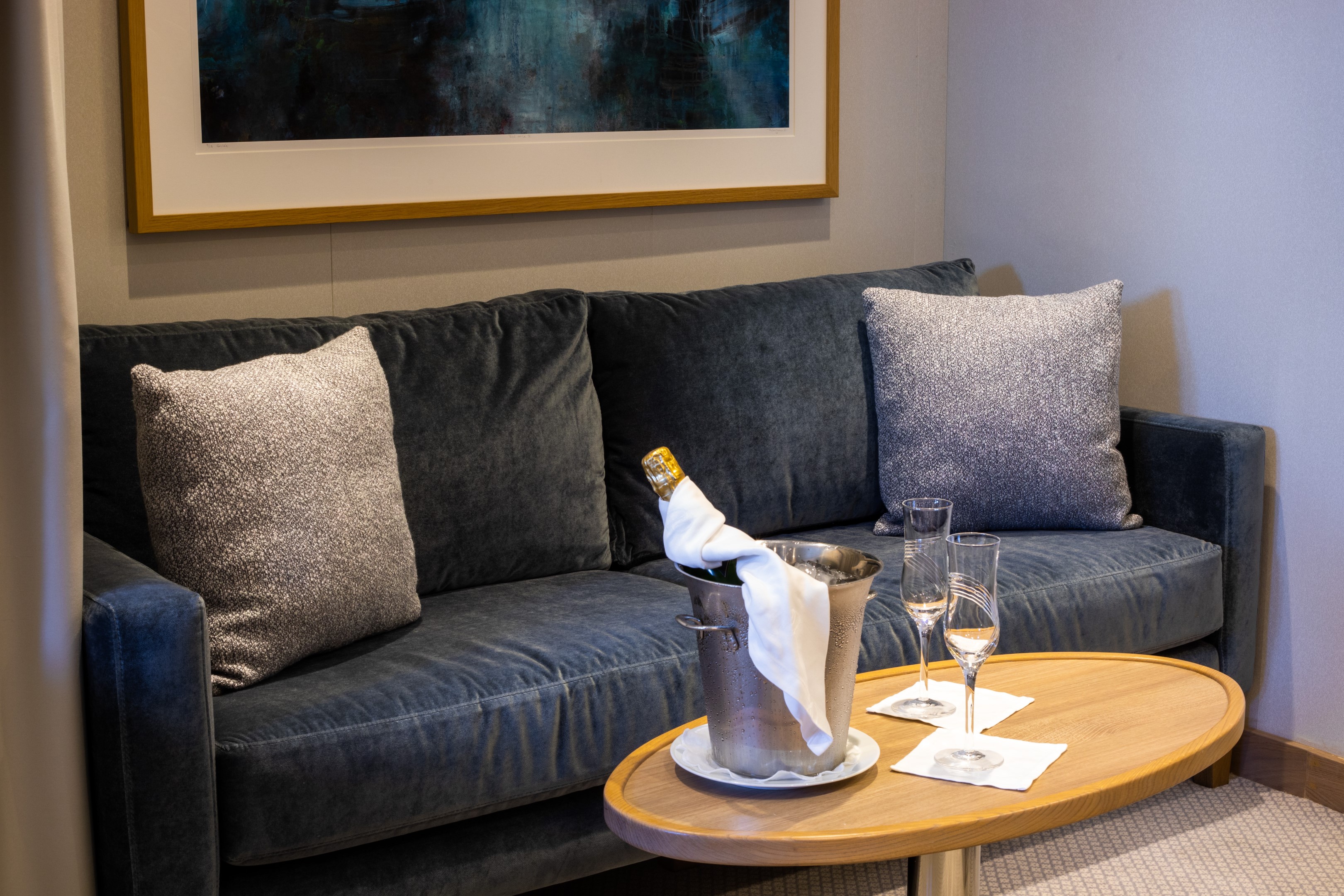
Your SeaDream journey begins the moment you step aboard, welcomed by the captain with cocktails and hors d'oeuvres as the yacht sets sail. With just 112 guests, a relaxed, uncrowded atmosphere and award-winning crew who anticipate your every need create an intimate, all-inclusive luxury yacht experience where every detail is thoughtfully curated.
This is yachting, the SeaDream way.
Starlit Movies™
Underneath the vast canvas of the night sky, your yacht comes alive with our signature Starlit Movies® poolside. Whether you're enjoying a classic film or the latest blockbuster, this open-air cinema transforms your evenings into cinematic adventures.
Balinese Dream Beds
Our signature Balinese Dream Beds are among the most distinctive all-inclusive yacht amenities at sea, inviting guests to stretch out and enjoy unobstructed ocean views by day or unwind beneath the stars by night. Select beds may be transformed for sleeping beneath the open sky, wrapped in luxurious Belgian linens as the sea moves softly beneath you.
Top of the Yacht Bar
Every moment aboard SeaDream is as effortless as the voyage itself. An open bar with select premium wines, spirits, and cocktails is available throughout the day, while evenings bring live music, social gatherings at the Top of the Yacht Bar, and Starlit Movies® on the open-air pool deck. With 360° ocean views as the backdrop and award-winning crew at your service, the night is always yours to enjoy.
Casino, Piano Bar & Library
Located on Deck 4, the casino offers a relaxed setting for classic table games, while the nearby Piano Bar invites guests to linger over after-dinner drinks with live guitar and piano music, perfect for conversation and unwinding at sea. For quieter moments, the library provides a peaceful onboard space with books and board games, a welcome retreat whenever the mood calls for stillness.
Concierge & Boutique
Our Concierge and Shop Manager are here to assist.