Lima to Papeete
Lima to Papeete
Cruise overview
WHY BOOK WITH US?
- ✔ The Deluxe Cruises’ team has extensive experience in ultra-luxury cruising.
- ✔ Call now to speak to our helpful and experienced Cruise Concierge team.
- ✔ Enjoy our Unique Deluxe Cruises Bonus for substantial savings.
- ✔ Our team will tailor your holiday to your exacting requirements.
- ✔ As agents, we work under the protection of each cruise lines ABTA / ATOL licences
About Callao
When people discuss great South American cities, Lima is often overlooked. But Peru's capital can hold its own against its neighbors. It has an oceanfront setting, colonial-era splendor, sophisticated dining, and nonstop nightlife.It's true that the city—clogged with traffic and choked with fumes—doesn't make a good first impression, especially since the airport is in an industrial neighborhood. But wander around the regal edifices surrounding the Plaza de Armas, among the gnarled olive trees of San Isidro's Parque El Olivar, or along the winding lanes in the coastal community of Barranco, and you'll find yourself charmed.In 1535 Francisco Pizarro found the perfect place for the capital of Spain's colonial empire. On a natural port, the so-called Ciudad de los Reyes (City of Kings) allowed Spain to ship home all the gold the conquistador plundered from the Inca. Lima served as the capital of Spain's South American empire for 300 years, and it's safe to say that no other colonial city enjoyed such power and prestige during this period.When Peru declared its independence from Spain in 1821, the declaration was read in the square that Pizarro had so carefully designed. Many of the colonial-era buildings around the Plaza de Armas are standing today. Walk a few blocks in any direction for churches and elegant houses that reveal just how wealthy this city once was. But the poor state of most buildings attests to the fact that the country's wealthy families have moved to neighborhoods to the south over the past century.The walls that surrounded the city were demolished in 1870, making way for unprecedented growth. A former hacienda became the graceful residential neighborhood of San Isidro. In the early 1920s the construction of tree-lined Avenida Arequipa heralded the development of neighborhoods such as bustling Miraflores and bohemian Barranco.Almost a third of the country's population of 29 million lives in the metropolitan area, many of them in relatively poor conos: newer neighborhoods on the outskirts of the city. Most residents of those neighborhoods moved there from mountain villages during the political violence and poverty that marked the 1980s and ’90s, when crime increased dramatically. During the past decade the country has enjoyed peace and steady economic growth, which have been accompanied by many improvements and refurbishment in the city. Residents who used to steer clear of the historic center now stroll along its streets. And many travelers who once would have avoided the city altogether now plan to spend a day here and end up staying two or three.

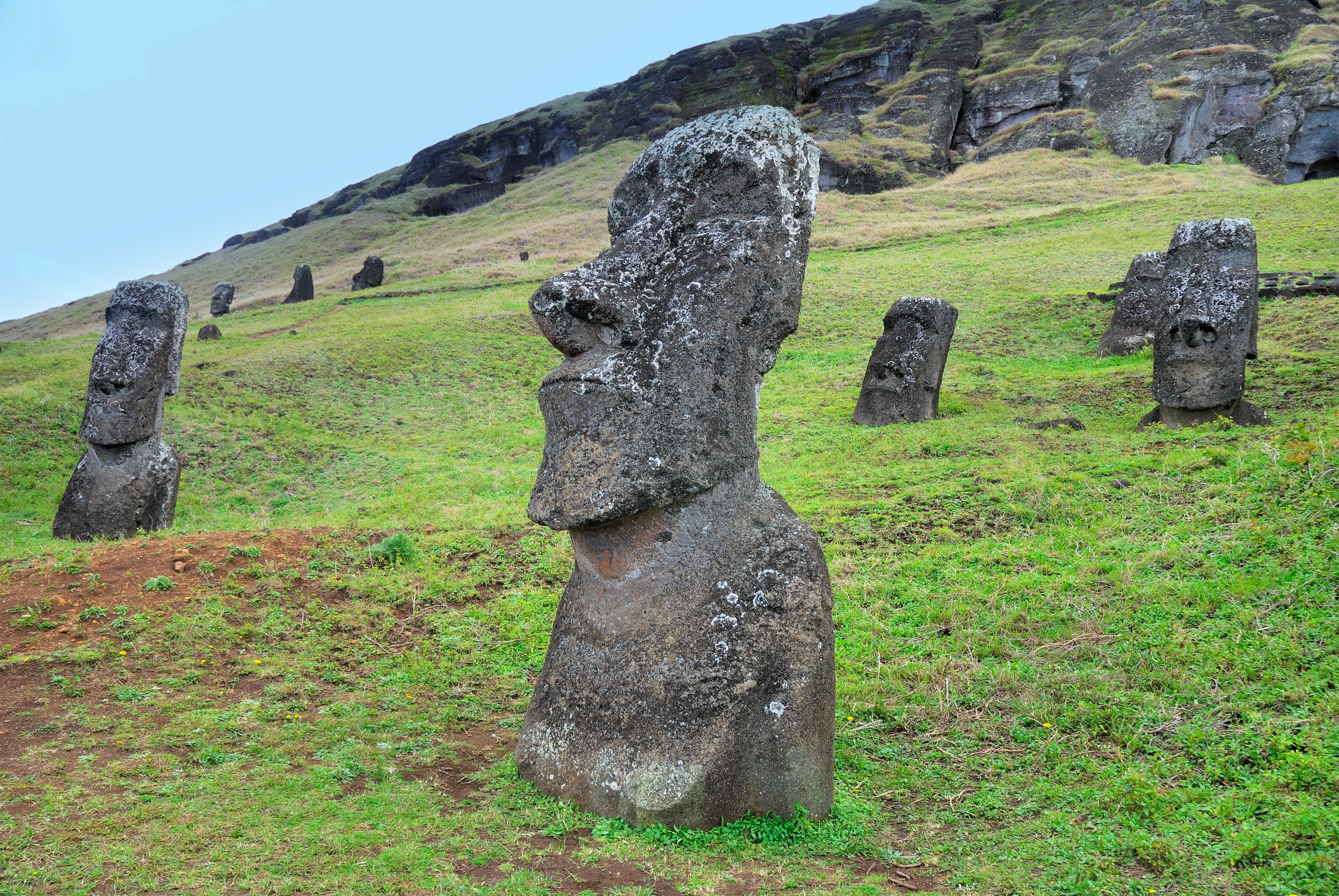
About Hangaroa, Easter Island
Discovered (by the Western world) on Easter Sunday, 1722, Easter Island is a UNESCO World Heritage Site and one of the most isolated places on the face of the Earth, some 2,300 miles from the Chilean mainland. Although more Polynesian than South American in character, the 64-square mile island was annexed by Chile in 1888, and is now famous as the world’s largest ‘open air museum’ on account of the Moai, or human-like stone statues, that can be found on the island. The Moai remain very much a mystery, which archaeologists are still trying to unlock by interpreting an ancient language of the Rapa Nui, which is the key to understanding this culture, and is written on the so called ‘rongo rongo tablets’. The island owes its origin to three volcanoes which erupted some three million years ago: Poike, Rano Kau and Maunga Terevaka. It is not known when or how the island was first populated, but the most credible theory suggests that the Rapa Nui people came from other Pacific islands in the 4th century AD. In addition to the cultural and archaeological interest, there are the beautiful beaches, transparent waters, and coral reefs that might be expected of a Pacific Island.
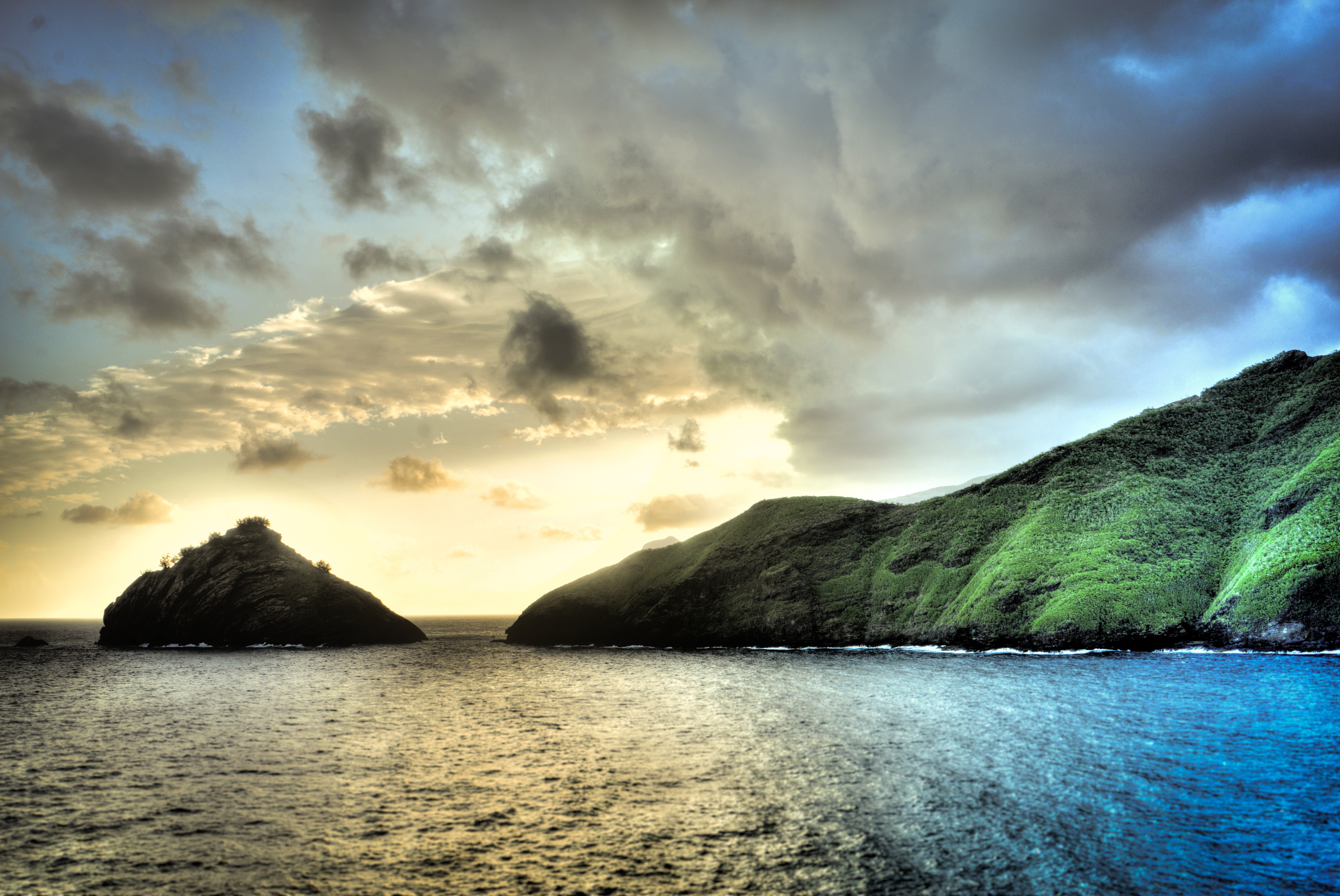
About Nuku Hiva Island
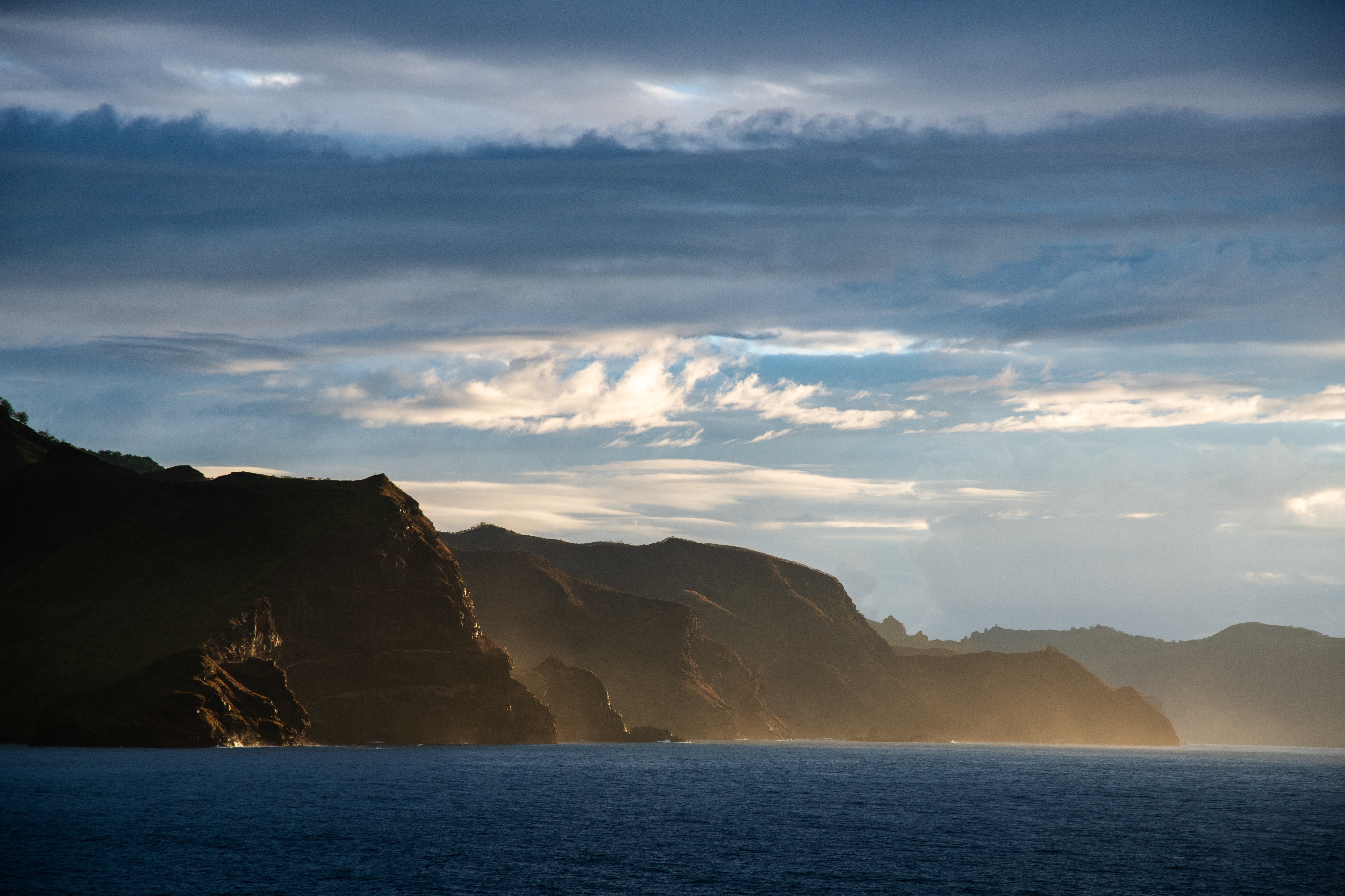
About Atuona, Hiva Oa
About Fakarava
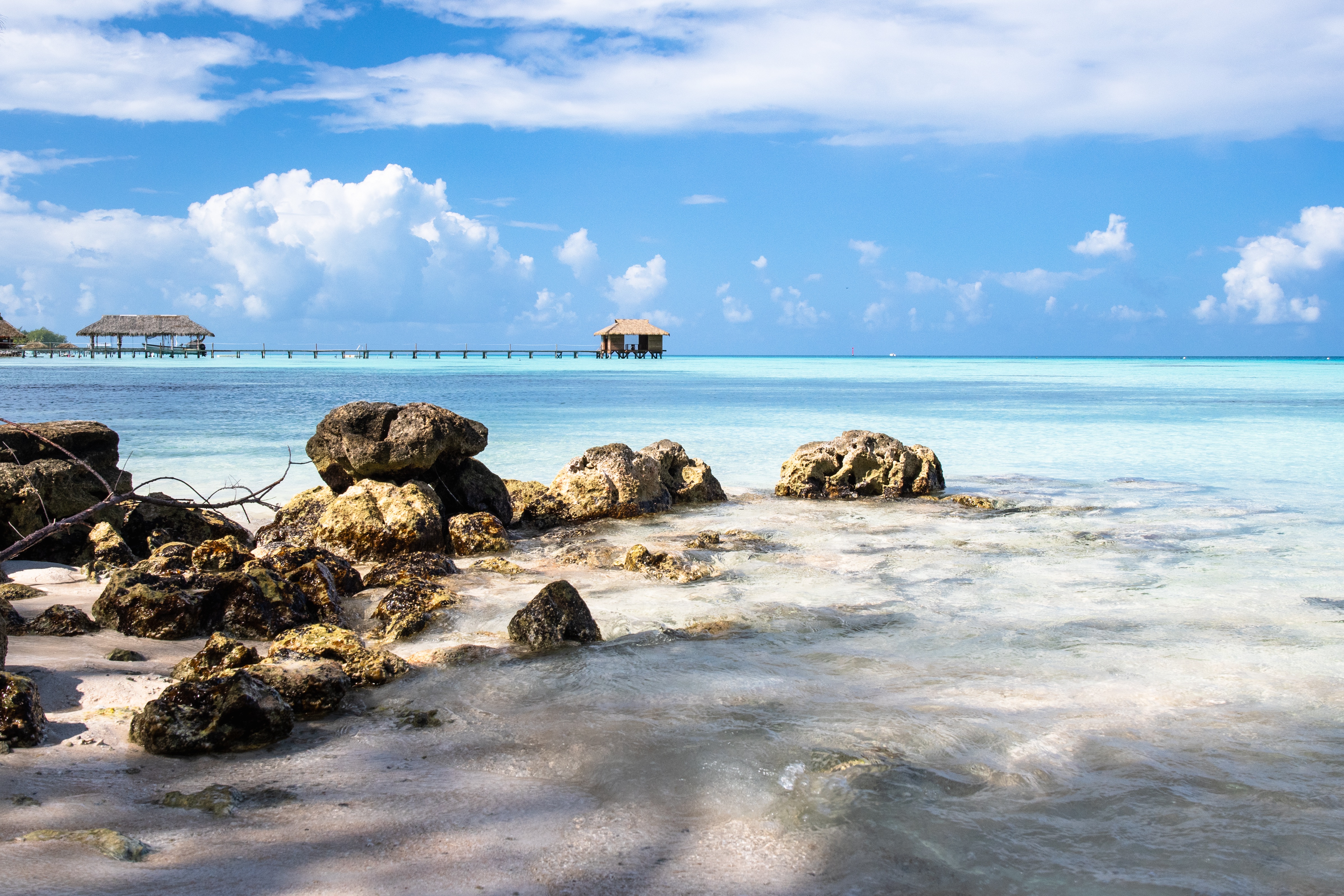
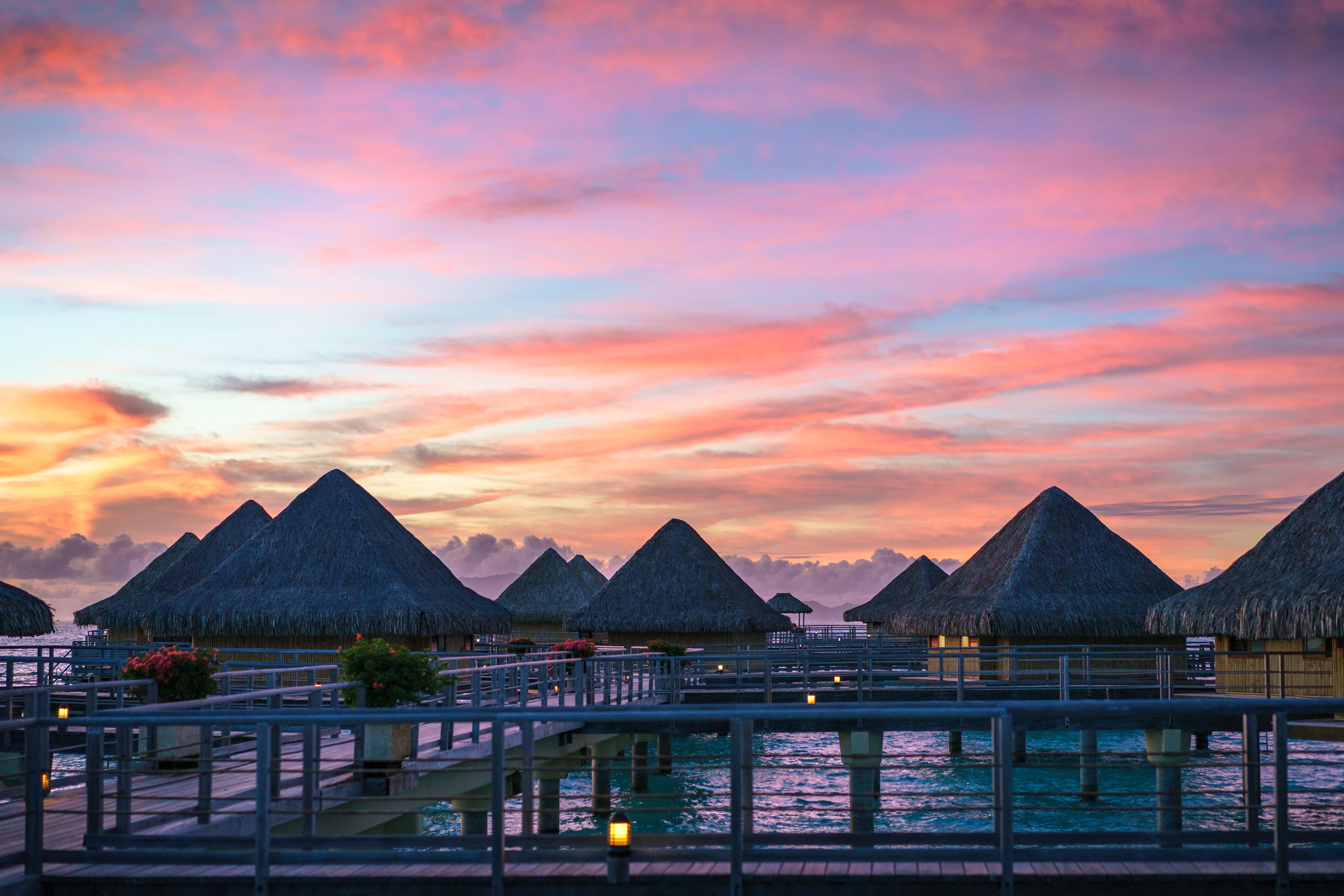
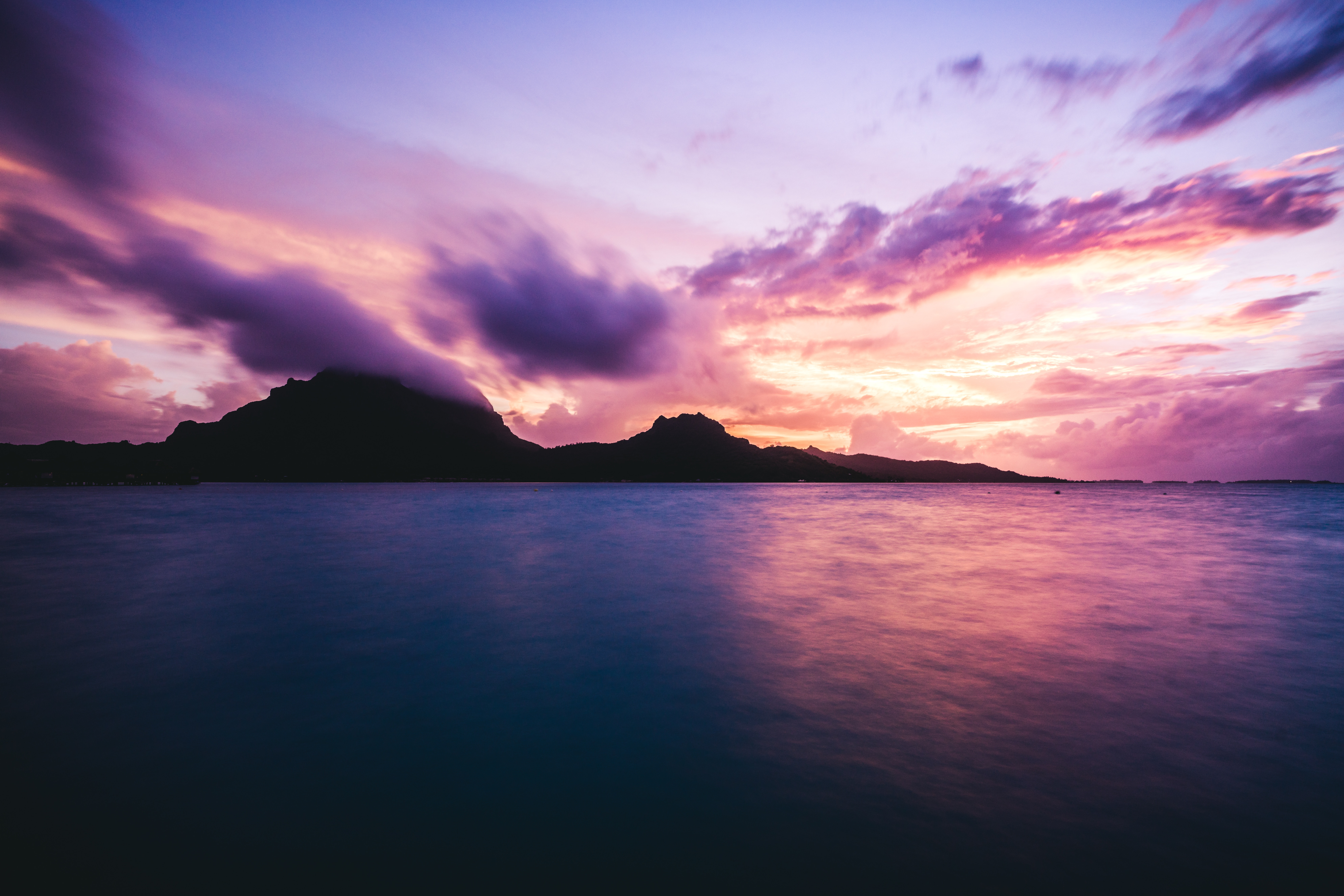
About Bora-Bora
Simply saying the name Bora Bora is usually enough to induce gasps of jealousy, as images of milky blue water, sparkling white beaches and casually leaning palm trees immediately spring to mind. The imagination doesn't lie, either, and if you visit, you’ll soon realise this island is every bit as gorgeous as you ever imagined. Thatched wooden huts stand out over shallow, sparkling seawater, with vivid fish swirling just below. Soak up the sun, scuba dive, or simply revel in the opulent luxury of one of the island's many magnificent resorts. If blissful inactivity doesn't appeal, then get active, and hike the greenery of the sharp Mount Pahia.
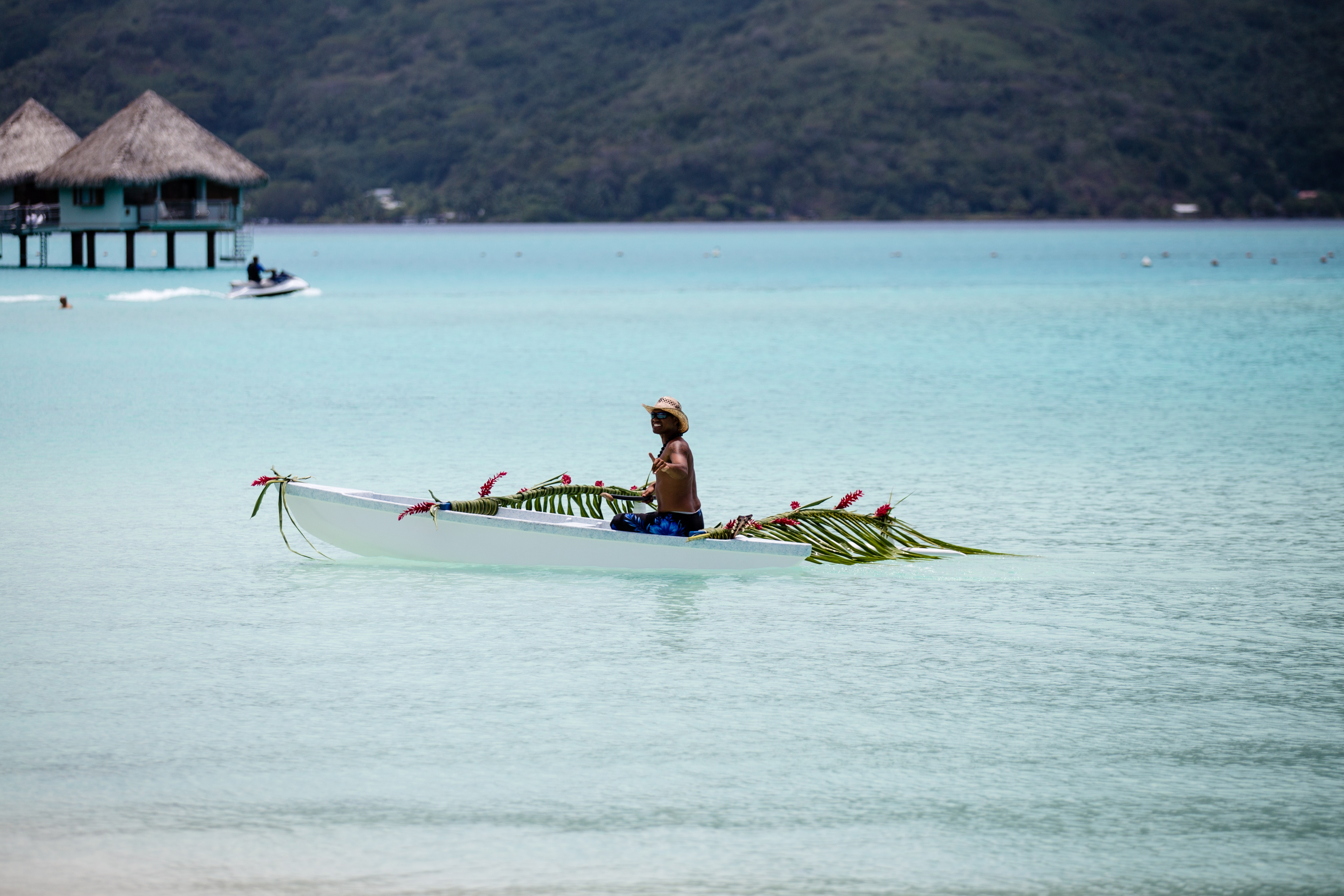
About Papeete, Tahiti
Papeete will be your gateway to the tropical paradise of French Polynesia, where islands fringed with gorgeous beaches and turquoise ocean await to soothe the soul. This spirited city is the capital of French Polynesia, and serves as a superb base for onward exploration of Tahiti – an island of breathtaking landscapes and oceanic vistas. Wonderful lagoons of crisp, clear water beg to be snorkelled, stunning black beaches and blowholes pay tribute to the island's volcanic heritage, and lush green mountains beckon you inland on adventures, as you explore extraordinary Tahiti. Visit to relax inside picturesque stilted huts, which stand out over shimmering water, as you settle into the intoxicating rhythm of life, in this Polynesian paradise.
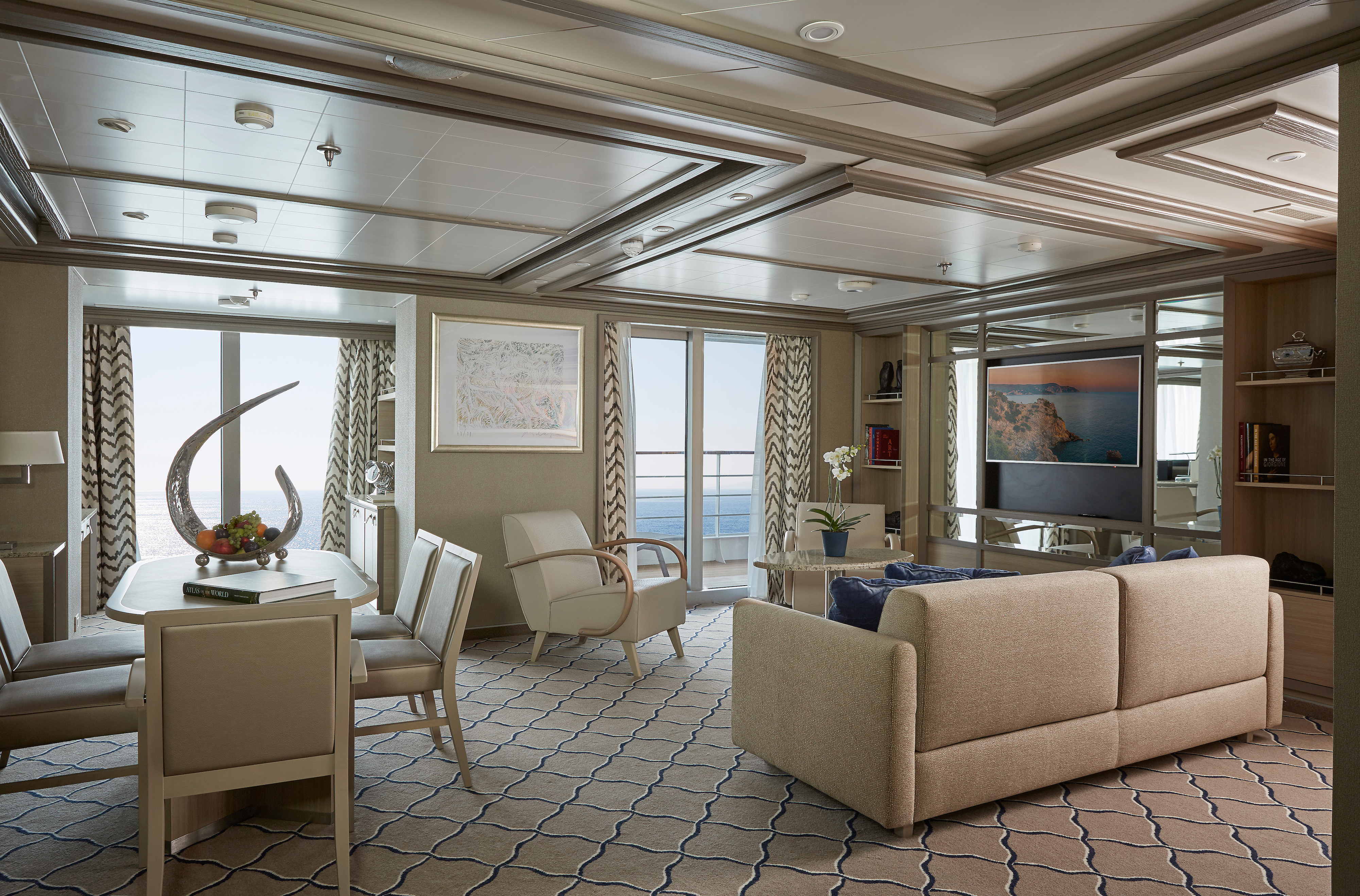
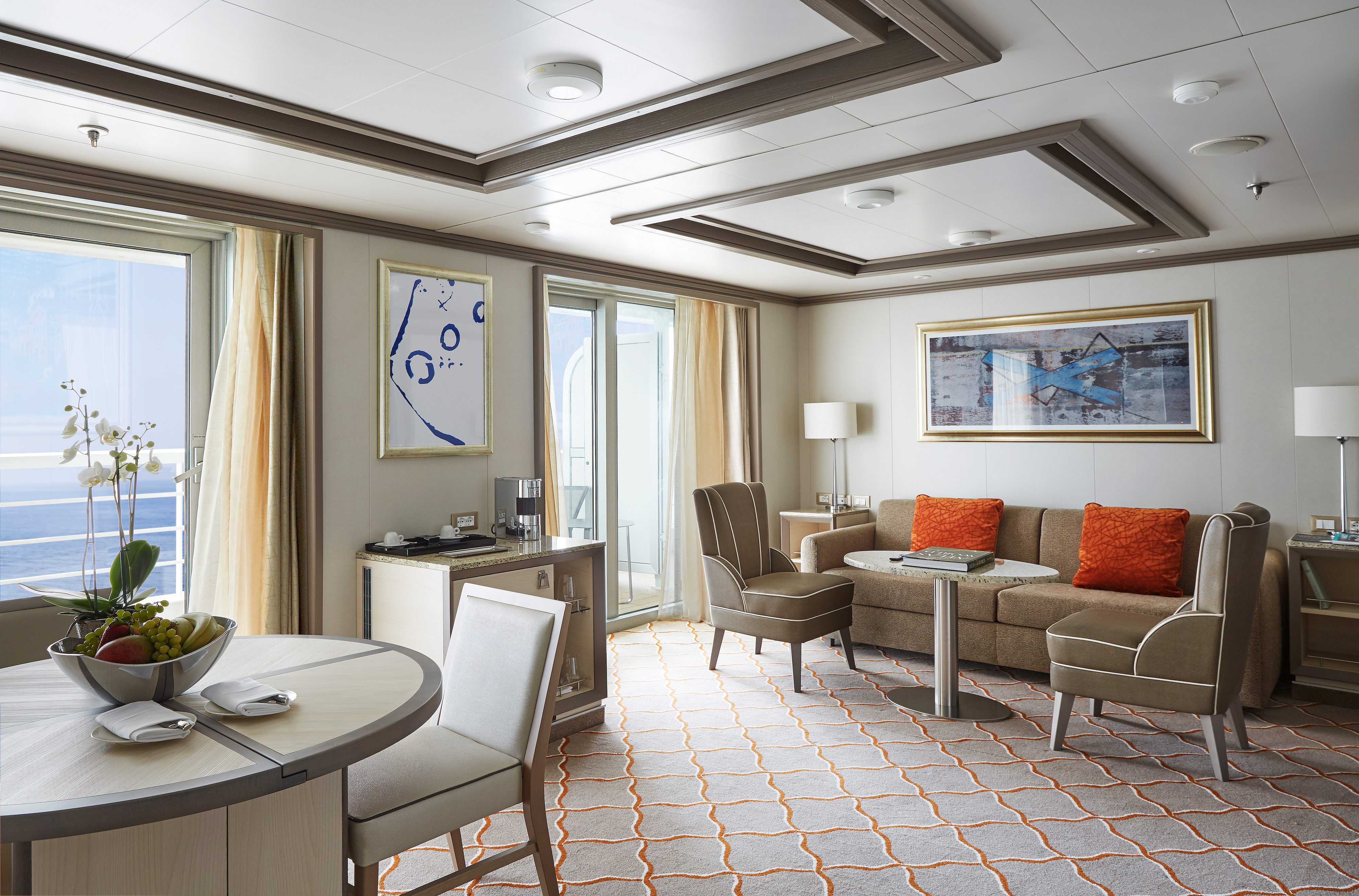
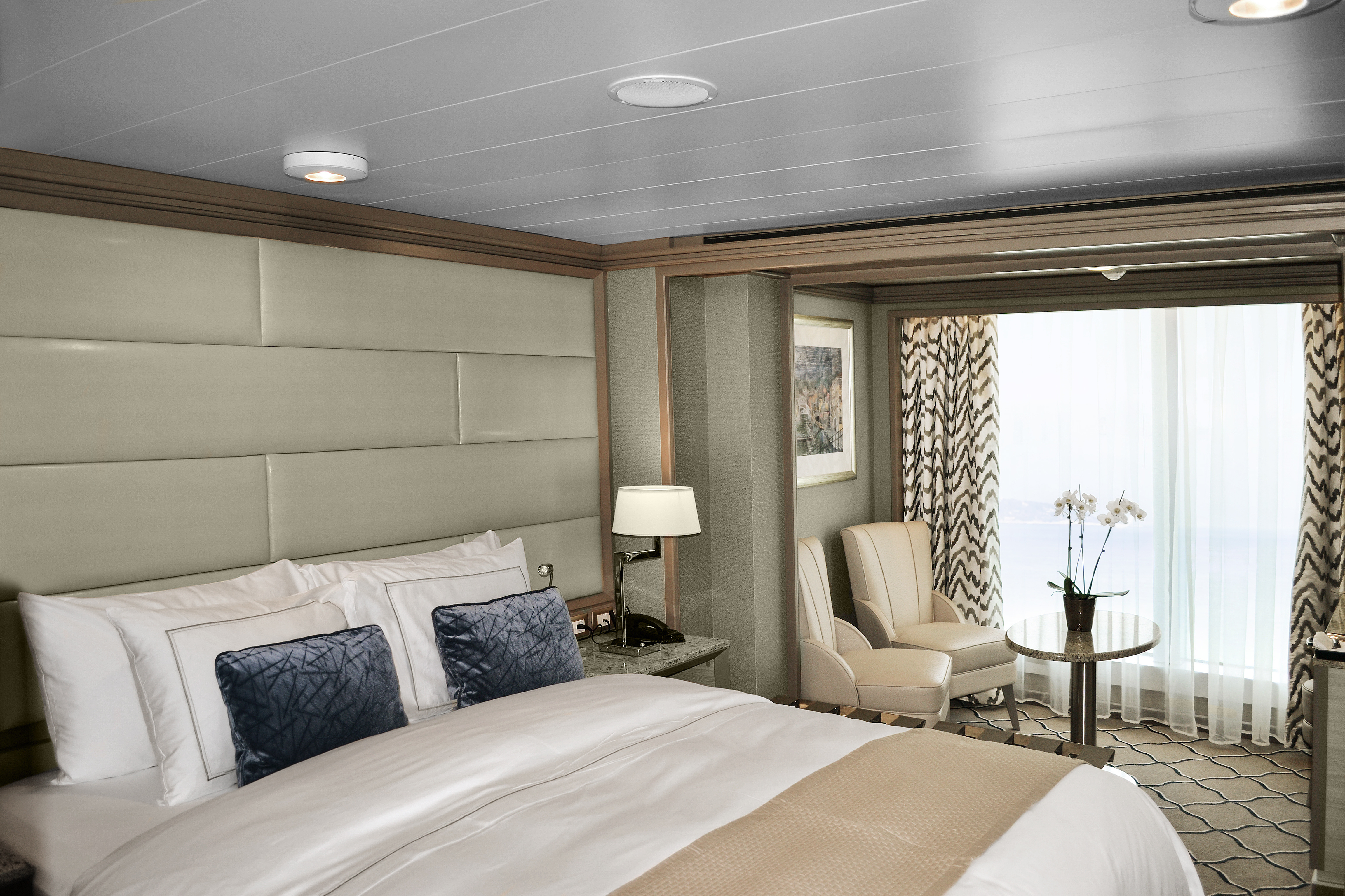
Available in a one- or two-bedroom configuration (so perfect for families), the Owner’s suite is the epitome of elegance at sea. A large seating area is the hub of the suite, equipped with all modern conveniences—think a Bose sound system, an interactive 55″ TV, and even an Illy coffee machine! Whether you are inside or relaxing on the large teak veranda, the Owner’s suite offers supreme comfort every hour of the day!
One bedroom: 88–98 sq m including veranda (12 sq m)
Two bedrooms: 119–129 sq m including veranda* (12 sq m )
*The difference in size is largely due to a larger entry corridor and does not affect the living or sleeping area.
Images are intended as a general reference. Features, materials, finishes and layout may be different than shown.
Please note that the third guest will sleep on a comfortable sofa bed in the reception area of the suite.
Essentials
- Deck(s): 9
- Section: Mid-Ship
Characteristics
- Veranda
- Separate dining area
- Living room with sitting area
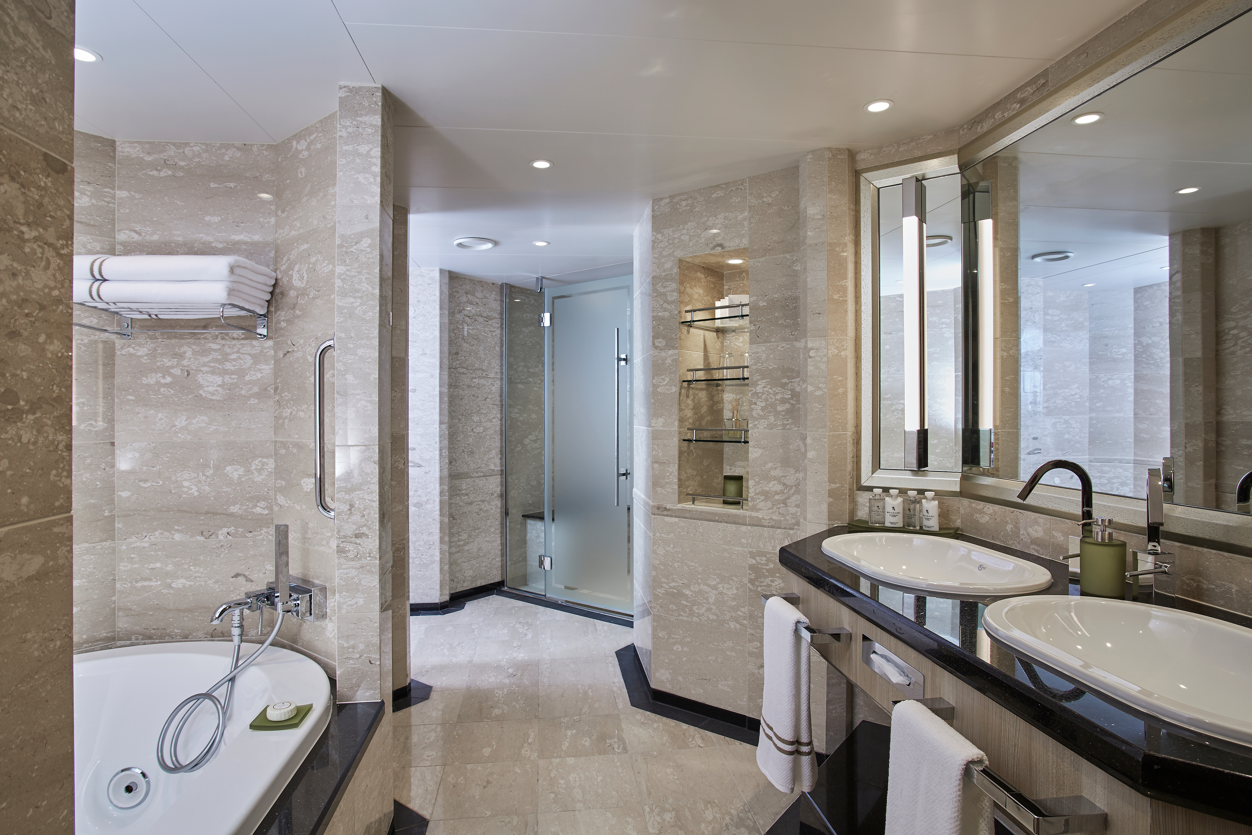
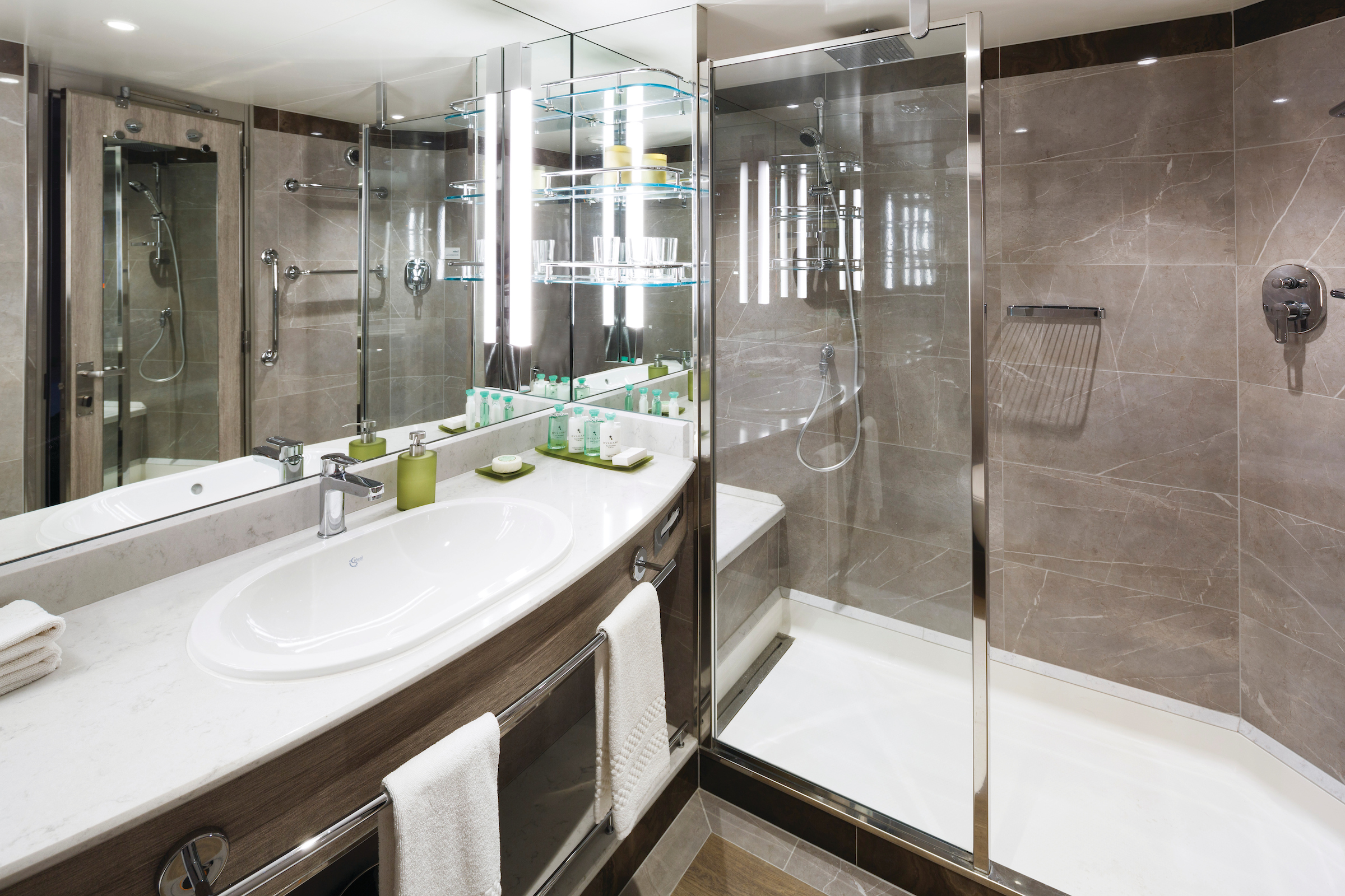
- Double vanity
- Separate shower
- Whirlpool bath
- Walk-in wardrobe with personal safe
Furniture
- King size bed
- Writing desk
- Vanity table
- Luxury bed mattresses
Media & Communication
- Unlimited Premium Wi-Fi
- 2 large flat screen TVs with Interactive Media Library
- Sound system with bluetooth connectivity
- Direct dial telephone
- Wall mounted USB-C mobile device chargers
- Dual voltage 110/220 outlets
Onboard Services
- Butler service
- Complimentary laundry, pressing & wet cleaning
- Dinner for two in La Dame, one evening per voyage,
- Two hours of worldwide phone use, per voyage segment
- Champagne on arrival
Amenities
- Espresso machine
- Pillow menu
- Refrigerator and bar setup stocked with your preferences
- Plush bathrobe
- Luxury bath amenities
- Umbrella
- Hair Dryer
- Slippers
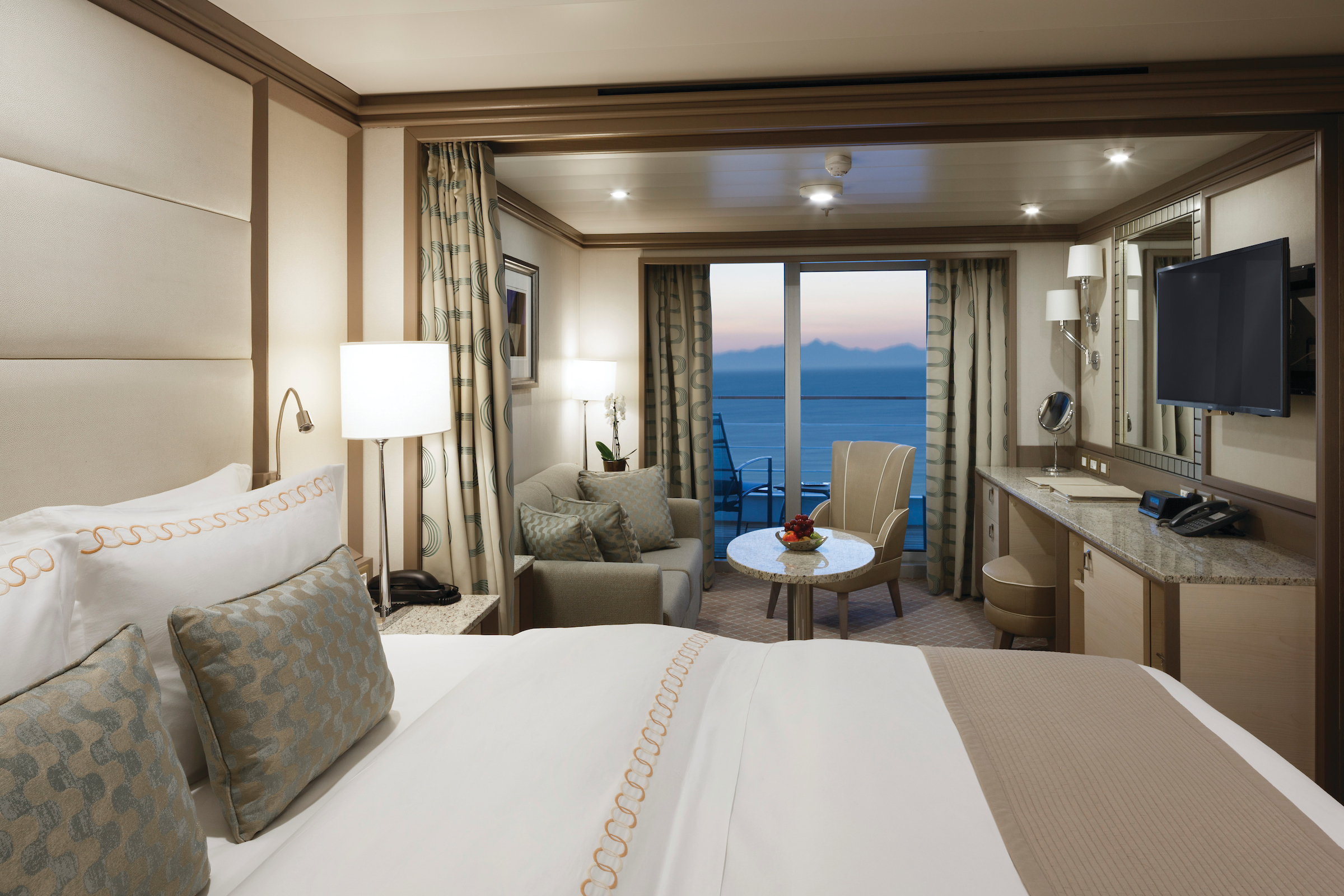
A grand traveler needs a grand suite, and we are happy to oblige! Get ready to scale new heights of comfort in our ultra-luxury Grand Suite. Situated at the front of the ship for the most spectacular views, the Grand Suite is for travelers who like the finer things in life. A large veranda, furnished with sun beds, makes for perfect memories. Indoors, the sumptuous seating area and cozy bedrooms are the very definition of relaxing in style.
One bedroom: 137–146 sq m including veranda (44–53 sq m)
Two bedrooms: 174–183 sq m including veranda (50–59 sq m)
Images are intended as a general reference. Features, materials, finishes and layout may be different than shown.
Please note that the 3rd guest will sleep on a comfortable sofa bed in the reception area of the suite.
Essentials
- Deck(s): 8, 9
- Section: Forward
Characteristics
- Veranda
- Separate dining area
- Living room with sitting area
- Double vanity
- Separate shower
- Whirlpool bath
- Walk-in wardrobe with personal safe
Furniture
- King size bed
- Writing desk
- Vanity table
- Luxury bed mattresses
Media & Communication
- Unlimited Premium Wi-Fi
- 2 large flat screen TVs with Interactive Media Library
- Sound system with bluetooth connectivity
- Direct dial telephone
- Wall mounted USB-C mobile device chargers
- Dual voltage 110/220 outlets
Onboard Services
- Butler service
- Complimentary laundry, pressing & wet cleaning
- Dinner for two in La Dame, one evening per voyage,
- Two hours of worldwide phone use, per voyage segment
- Champagne on arrival
Amenities
- Espresso machine
- Pillow menu
- Refrigerator and bar setup stocked with your preferences
- Plush bathrobe
- Luxury bath amenities
- Umbrella
- Hair Dryer
- Slippers
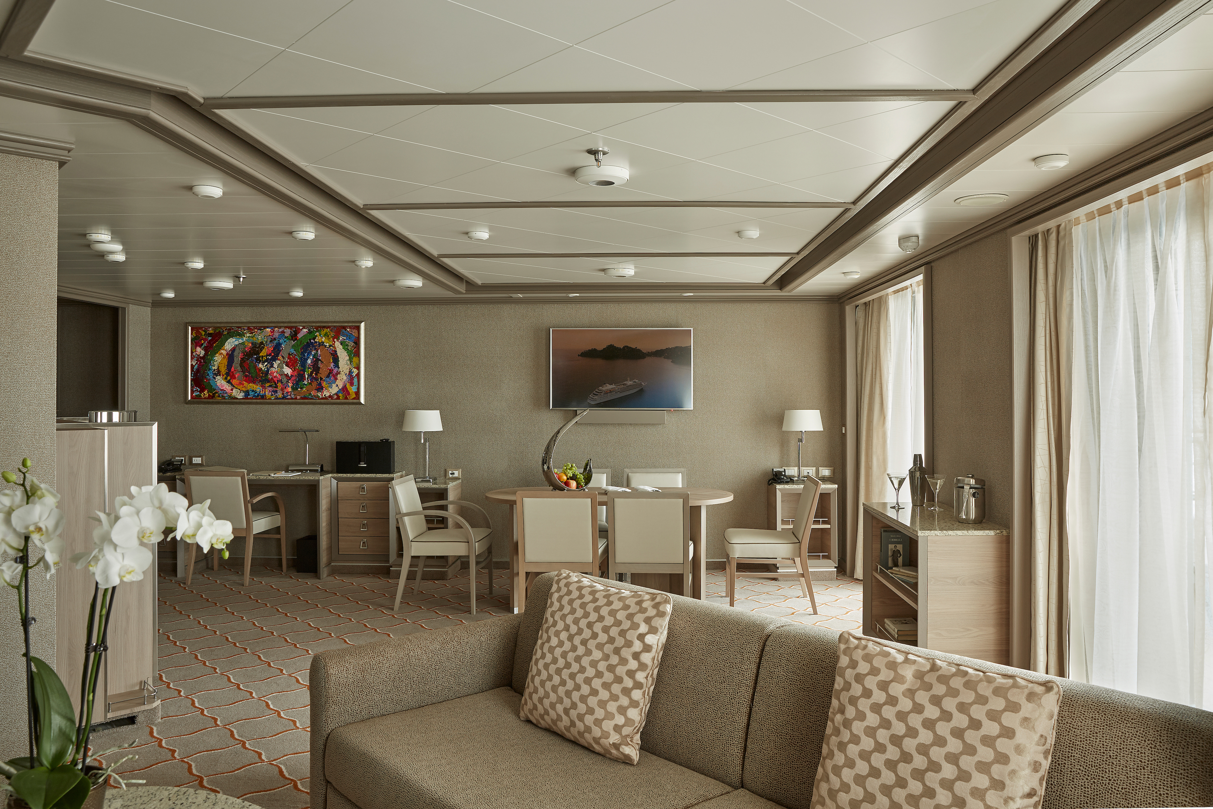

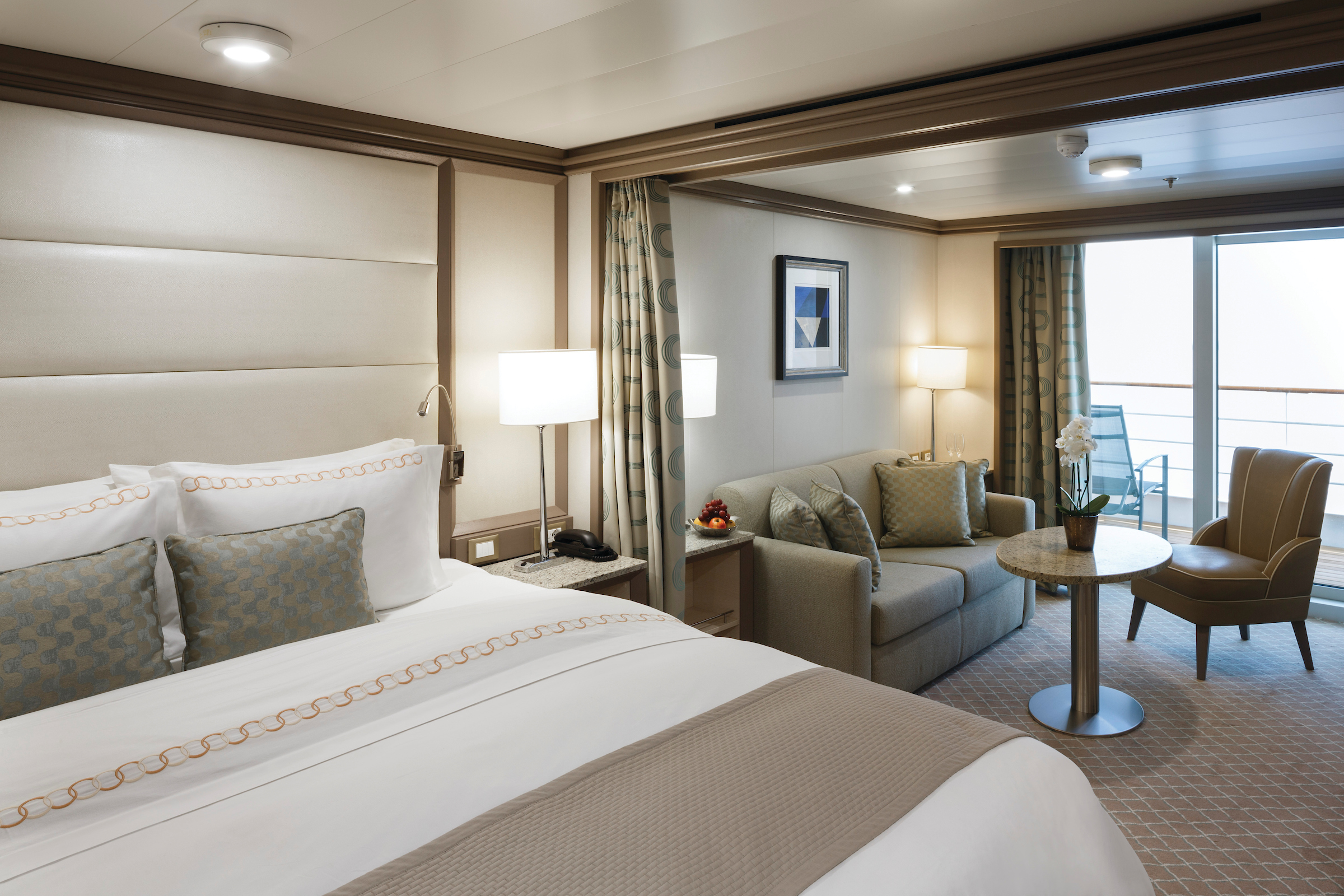
With just two Royal Suites on board, this stateroom is in a class all of its own! Spacious and dignified, commanding and majestic, there’s no secret to why we named this the Royal Suite. Ample indoor space with a living room (including state-of-the-art entertainment systems), twin beds that can be joined upon demand, and even an adjoining bedroom if required—the Royal Suite is the answer when traveling with the family! Not to mention unlimited Wi-Fi, a sumptuous marble bathroom, and spacious teak veranda—the Royal Suite is fit for a king!
One bedroom: 105 sq m including veranda (12 sq m)
Two bedrooms: 142 sq m including veranda (18 sq m )
Images are intended as a general reference. Features, materials, finishes and layout may be different than shown.
Please note that the 3rd guest will sleep on a comfortable sofa bed in the reception area of the suite.
Essentials
- Deck(s): 7
- Section: Forward
Characteristics
- Veranda
- Separate dining area
- Living room with sitting area
- Double vanity
- Separate shower
- Whirlpool bath
- Walk-in wardrobe with personal safe
Furniture
- King size bed
- Writing desk
- Vanity table
- Luxury bed mattresses
Media & Communication
- Unlimited Premium Wi-Fi
- 2 large flat screen TVs with Interactive Media Library
- Sound system with bluetooth connectivity
- Direct dial telephone
- Wall mounted USB-C mobile device chargers
- Dual voltage 110/220 outlets
Onboard Services
- Butler service
- Complimentary laundry, pressing & wet cleaning
- Dinner for two in La Dame, one evening per voyage,
- Two hours of worldwide phone use, per voyage segment
- Champagne on arrival
Amenities
- Espresso machine
- Pillow menu
- Refrigerator and bar setup stocked with your preferences
- Plush bathrobe
- Luxury bath amenities
- Umbrella
- Hair Dryer
- Slippers
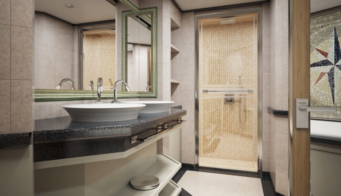
A Silversea favorite and by far our best-selling suite! The Silver Suite is one of the foundations of ultra-luxury cruising. Take traveling to a whole new level with the Silver Suite’s unparalleled levels of service, comfort, and of course, style! Available in either a one-bedroom, a two-bedroom, or wheelchair accessible configuration, Silver Suites are fully equipped for the discerning traveler. Whether enjoying the spectacular views from the veranda or relaxing in the large sitting room, Silver Suites offer a comfortable haven on the high seas.
One bedroom: 73 sq m including veranda (12 sq m)
Two bedrooms: 104 sq m including veranda (12 sq m)
Wheelchair accessible suite: 931
Images are intended as a general reference. Features, materials, finishes and layout may be different than shown.
Please note that the 3rd guest will sleep on a comfortable sofa bed in the reception area of the suite.
Essentials
- Deck(s): 9, 10, 11
- Section: Forward, Mid-Ship
Characteristics
- Veranda
- Living room with sitting area
- Double vanity
- Separate shower
- Whirlpool bath
- Walk-in wardrobe with personal safe
Furniture
- King size bed
- Writing desk
- Vanity table
- Luxury bed mattresses
Media & Communication
- Unlimited Premium Wi-Fi
- 2 large flat screen TVs with Interactive Media Library
- Sound system with bluetooth connectivity
- Direct dial telephone
- Wall mounted USB-C mobile device chargers
- Dual voltage 110/220 outlets
Onboard Services
- Butler service
- Complimentary laundry, pressing & wet cleaning
- Champagne on arrival
Amenities
- Espresso machine
- Pillow menu
- Refrigerator and bar setup stocked with your preferences
- Plush bathrobe
- Luxury bath amenities
- Umbrella
- Hair Dryer
- Slippers
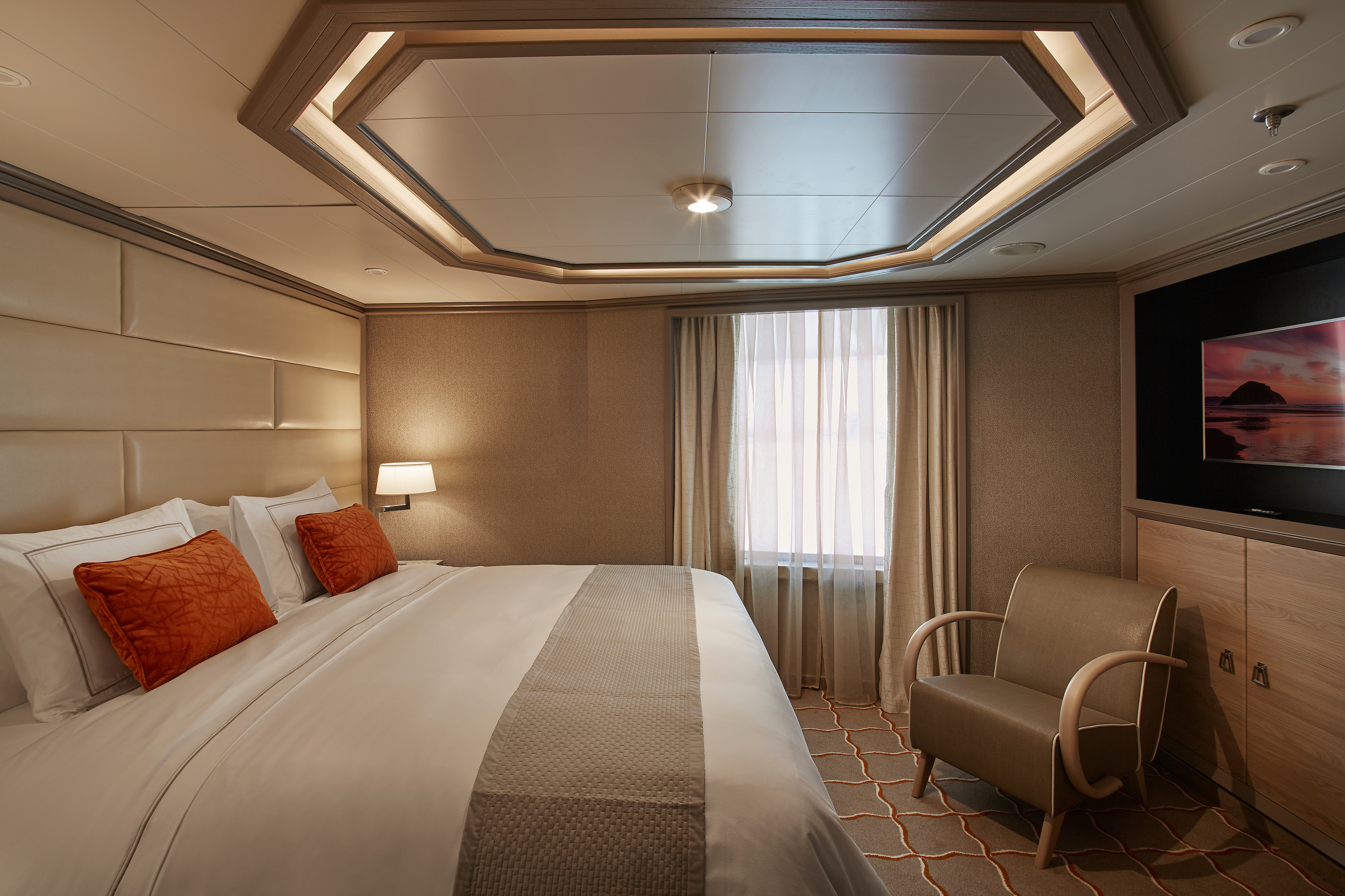
After a busy day of onshore exploring, the Deluxe Veranda Suite is the perfect home away from home. Spacious and well-situated, enjoy ultra-luxury amenities from the 24-hour butler service to the well-stocked mini-bar (and yes, they’re all included!). Not forgetting the teak veranda from which the suite takes her name, the Deluxe Veranda is the perfect setting for making perfect memories.
One bedroom: 36 sq m including veranda (6 sq m)
Images are intended as a general reference. Features, materials, finishes and layout may be different than shown.
Please note that the 3rd guest will sleep on a comfortable sofa bed in the reception area of the suite.
Essentials
- Deck(s): 6, 7, 8
- Section: Mid-Ship
Characteristics
- Veranda
- Sitting area
- Standard vanity
- Separate shower
- Full-size bath
- Walk-in wardrobe with personal safe
Furniture
- Queen size bed
- Writing desk
- Luxury bed mattresses
Media & Communication
- Unlimited Standard Wi-Fi
- 1 large flat screen TV with Interactive Media Library
- Direct dial telephone
- Wall mounted USB-C mobile device chargers
- Dual voltage 110/220 outlets
Onboard Services
- Butler service
- Champagne on arrival
Amenities
- Pillow menu
- Refrigerator and bar setup stocked with your preferences
- Plush bathrobe
- Luxury bath amenities
- Umbrella
- Hair Dryer
- Slippers
A superior location makes the Superior Veranda Suite, well … superior! From the sumptuous views from the teak veranda to the spacious sitting room and large marble bathroom, everything about the Superior Veranda has been designed for your comfort. So settle in and get comfortable, order some 24-hour room service from your butler and enjoy a bit of R&R. We guarantee you won’t want to leave.
One bedroom: 36 sq ft including veranda (6 sq m)
Images are intended as a general reference. Features, materials, finishes and layout may be different than shown.
Please note that the third guest will sleep on a comfortable sofa bed in the reception area of the suite.
Essentials
- Deck(s): 7, 8, 9
- Section: Forward
Characteristics
- Veranda
- Sitting area
- Standard vanity
- Separate shower
- Full-size bath
- Walk-in wardrobe with personal safe
Furniture
- Queen size bed
- Writing desk
- Luxury bed mattresses
Media & Communication
- Unlimited Standard Wi-Fi
- 1 large flat screen TV with Interactive Media Library
- Direct dial telephone
- Wall mounted USB-C mobile device chargers
- Dual voltage 110/220 outlets
Onboard Services
- Butler service
- Champagne on arrival
Amenities
- Pillow menu
- Refrigerator and bar setup stocked with your preferences
- Plush bathrobe
- Luxury bath amenities
- Umbrella
- Hair Dryer
- Slippers
A lower-bow location makes the Classic Veranda Suite a comfortable choice for travelers. A lovely, comfortable bed—available in a twin- or queen-bed configuration—with a choice of mattress ensures that you enjoy the best night’s sleep of your life while the seating area is perfect for in-suite dining. But perhaps the Classic Veranda’s best feature lies outside the suite—with the 6-m2 (64-sq-ft) veranda for which the suite was named.
One bedroom: 36 sq m including veranda (6 sq m)
Images are intended as a general reference. Features, materials, finishes and layout may be different than shown.
Essentials
- Deck(s): 5, 6
- Section: Forward
Characteristics
- Veranda
- Sitting area
- Standard vanity
- Separate shower
- Full-size bath
- Walk-in wardrobe with personal safe
Furniture
- Queen size bed
- Writing desk
- Luxury bed mattresses
Media & Communication
- Unlimited Standard Wi-Fi
- 1 large flat screen TV with Interactive Media Library
- Direct dial telephone
- Wall mounted USB-C mobile device chargers
- Dual voltage 110/220 outlets
Onboard Services
- Butler service
- Champagne on arrival
Amenities
- Pillow menu
- Refrigerator and bar setup stocked with your preferences
- Plush bathrobe
- Luxury bath amenities
- Umbrella
- Hair Dryer
- Slippers
Beautiful elegant furnishings are the perfect choice to soothe and relax as you sail from one destination to the next. Large windows flood the room with light, making for luxurious ocean views whether it’s morning, noon, or night! Panorama Suites are the perfect accompaniment to a Silver Suite for larger parties, or just perfect on their own. With all the modern conveniences that you would expect from an ultra-luxury cruise line, Panorama Suites offer comfort, space, and style!
One bedroom: 31 sq m
Images are intended as a general reference. Features, materials, finishes and layout may be different than shown.
Essentials
- Deck(s): 9
- Section: Forward
Characteristics
- Floor-to ceiling window
- Sitting area
- Standard vanity
- Separate shower
- Full-size bath
- Walk-in wardrobe with personal safe
Furniture
- Queen size bed
- Writing desk
- Luxury bed mattresses
Media & Communication
- Unlimited Standard Wi-Fi
- 1 large flat screen TV with Interactive Media Library
- Direct dial telephone
- Wall mounted USB-C mobile device chargers
- Dual voltage 110/220 outlets
- Butler service
- Champagne on arrival
Amenities
- Pillow menu
- Refrigerator and bar setup stocked with your preferences
- Plush bathrobe
- Luxury bath amenities
- Umbrella
- Hair Dryer
- Slippers
Comfortable, spacious, and offering stupendous ocean views, the Vista Suite carries its name very well! Wake up to wide ocean views, eat breakfast to the sound of the waves lapping at the side of the ship, or simply relax with the in-suite entertainment system and comfy sofas. Some Vista Suites are a little larger than standard—perfect for our guests with limited mobility. If you have ever wanted a home away from home on the high seas, the Vista Suite is it.
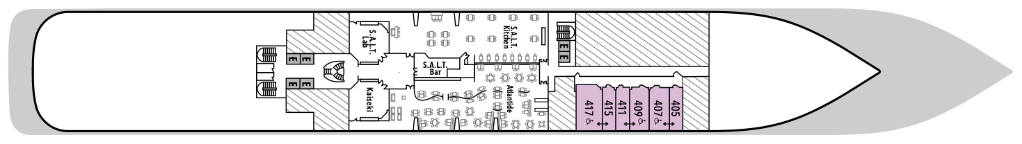
One bedroom: 32 sq m
Wheelchair accessible suites: 407, 409, 417
Images are intended as a general reference. Features, materials, finishes and layout may be different than shown.
Essentials
- Deck(s): 4
- Section: Forward
Characteristics
- Window
- Sitting area
- Standard vanity
- Separate shower
- Full-size bath
- Walk-in wardrobe with personal safe
Furniture
- Queen size bed
- Writing desk
- Luxury bed mattresses
Media & Communication
- Unlimited Standard Wi-Fi
- 1 large flat screen TV with Interactive Media Library
- Direct dial telephone
- Wall mounted USB-C mobile device chargers
- Dual voltage 110/220 outlets
Onboard Services
- Butler service
- Champagne on arrival
Amenities
- Pillow menu
- Refrigerator and bar setup stocked with your preferences
- Plush bathrobe
- Luxury bath amenities
- Umbrella
- Hair Dryer
- Slippers
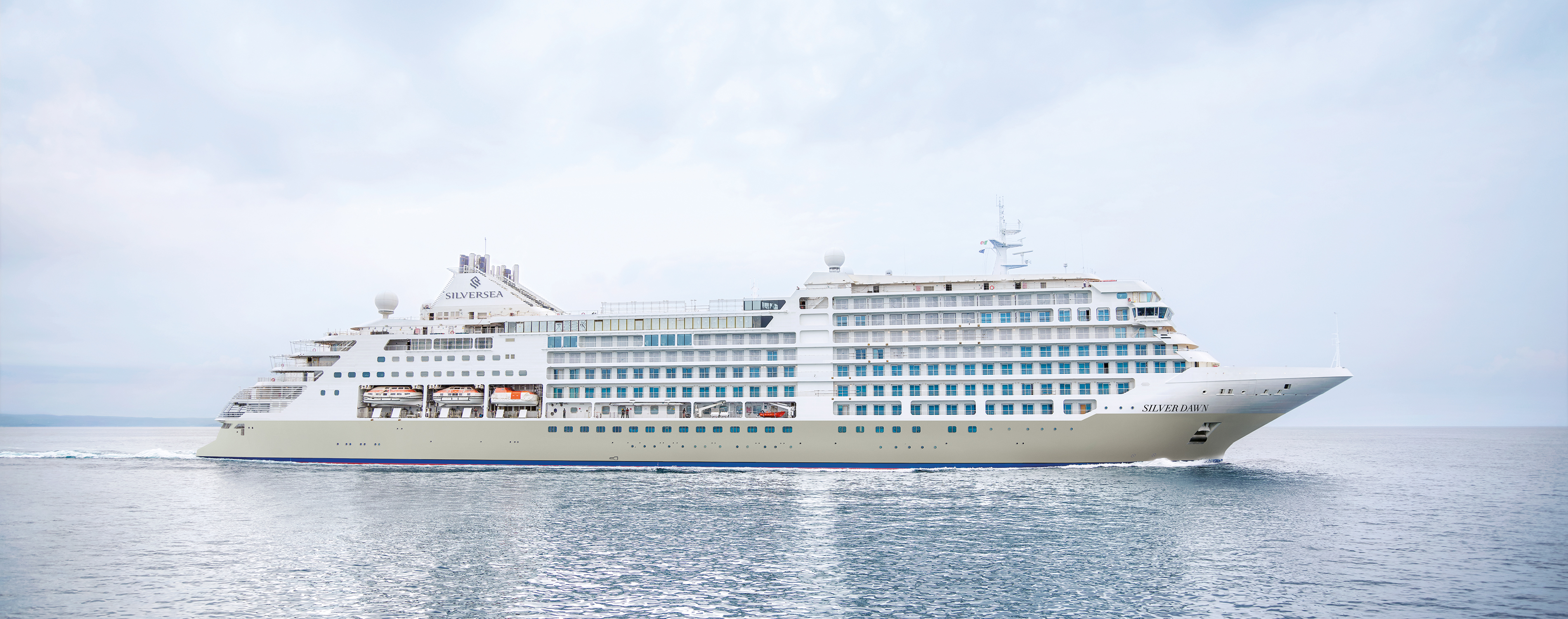
Silver Dawn
A new world of luxury is waiting aboard Silver Dawn. Elegant and modern, Silver Dawn is the natural evolution of our fleet. Large enough to offer eight dining options—including the superb Sea and Land Taste (S.A.L.T.) program—yet small enough for the famed Silversea onboard ambience, Silver Dawn inherits the best features of her sister ships Silver Muse and Silver Moon, but is in a class all of her own. With sumptuous suites, outstanding itineraries, plus cutting-edge design and technology, and the outstanding OTIVM wellness concept, Silver Dawn sets new standards of luxury. Wake up to a new dawn with Silversea.
Ship Facts
| Launch Year | 2022 | ||||||||||
| Refit Year | |||||||||||
| Language | en | ||||||||||
| Gross Tonnage | 40700 | ||||||||||
| Length | 213 | ||||||||||
| Width | 26 | ||||||||||
| Currency | USD | ||||||||||
| Speed | 20 | ||||||||||
| Capacity | 596 | ||||||||||
| Crew Count | 411 | ||||||||||
| Deck Count | 8 | ||||||||||
| Cabin Count | 288 | ||||||||||
| Large Cabin Count | N/A | ||||||||||
| Wheelchair Cabin Count | 4 | ||||||||||
| Electrical Plugs |
|
Deck 11
- Observation Library
- Spaccanapoli
- Jogging Track
- Silver Suites
- Elevator

Deck 10
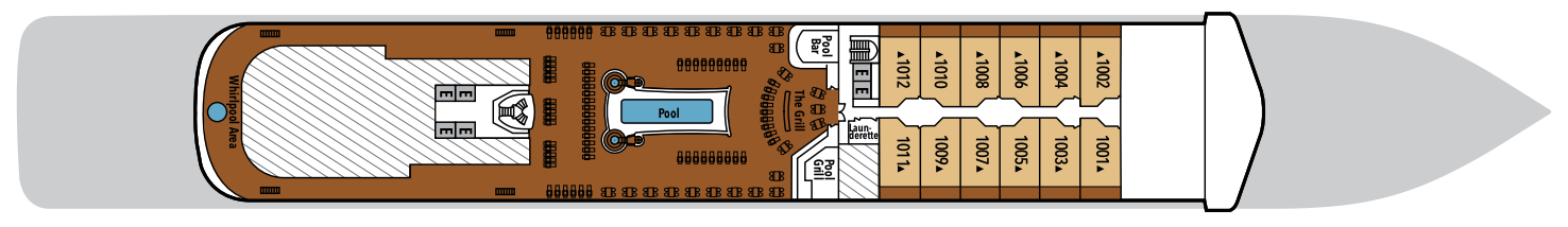
- Pool Deck
- Pool Bar
- Launderette
- The Grill
- Whirlpool Area
- Silver Suite
- Elevator
Deck 9
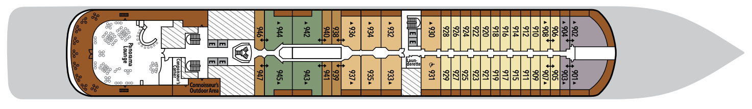
- Panorama Lounge
- Connoisseur's Corner
- Launderette
- Owner's Suite
- Panorama Suite
- Silver Suite
- Superior Veranda Suite
- Grand Suite
- Elevator
Deck 8
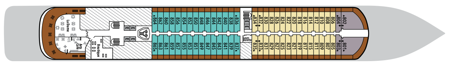
- Arts Café
- Boutique
- La Dame
- Launderette
- Deluxe Veranda Suite
- Superior Veranda suite
- Grand Suite
- Elevator
Deck 7
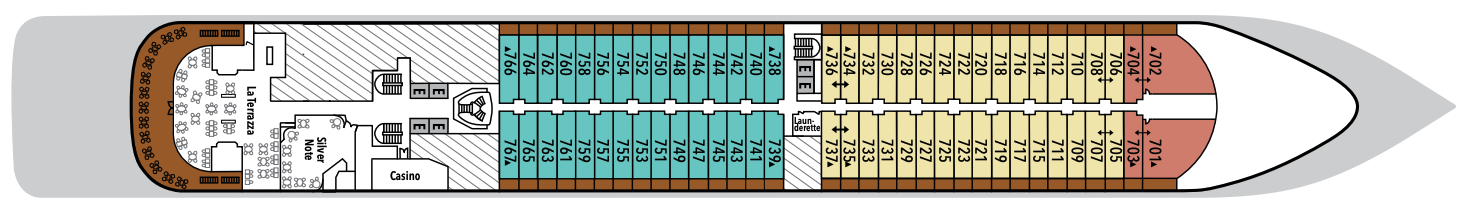
- La Terrazza
- Silver Note
- Casino
- Launderette
- Royal Suite
- Superior Veranda Suite
- Deluxe Veranda Suite
- Elevator
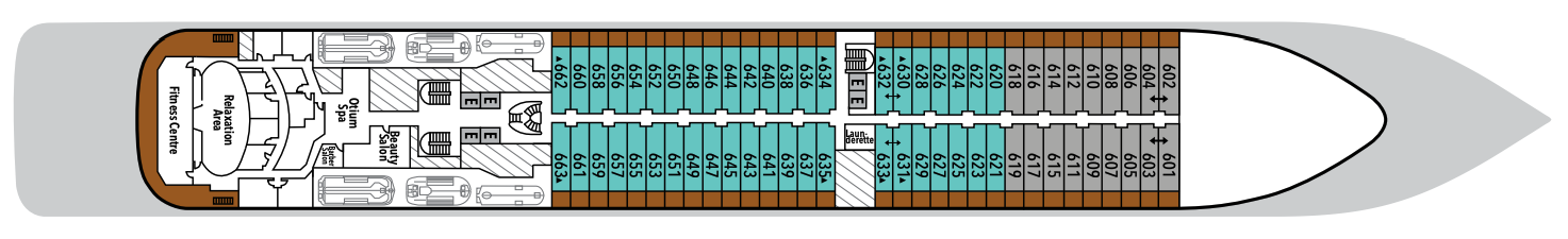
Deck 6
- Otium Spa
- Fitness Centre
- Relaxation Area
- Beauty Salon
- Launderette
- Deluxe Veranda Suite
- Classic Veranda Suite
- Elevator
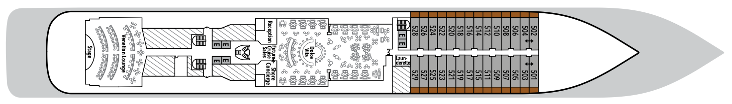
Deck 5
- Reception/Guest Relations
- Shore Concierge
- Dolce Vita
- Venetian Lounge
- Future Cruise Sales
- Launderette
- Cruise Consultant
- Classic Veranda Suite
- Elevator
Deck 4
- Atlantide
- Kaiseki
- S.A.L.T Kitchen
- S.A.L.T Bar
- S.A.L.T Lab
- Vista Suite (3x Accessible)
- Elevator
With the importance of food in Italian culture you would expect dining to be a high priority at Silversea. And it most assuredly is. Moreover, gastronomic excellence is a given, thanks to our recipes that reflect heritage and revamp tradition. No matter where you dine, destination influence is readily apparent in the great diversity and freshness of your selections. And every ship also features an array of dining venues. The main dining room, The Restaurant, is an open-seating venue where you can dine whenever you please, and where impromptu dinners with new-found friends is a matter of course. After all, with our worldly crowd of international travellers, socialising is one of the things people love most about our luxury cruise ships.
Select wines, premium spirits, speciality coffees, as well as bottled water, juices and soft drinks are complimentary in all bars and lounges. Your suite’s mini-bar is also stocked with your preferred beverages including wines and spirits. Your butler will replenish them upon request.
S.A.L.T. Kitchen
Take your travel experience further than ever before in the S.A.L.T. Kitchen. Silver Dawn’s exclusive destination-focused restaurant is the place to be when it comes to enjoying the local cuisine, culture, and rich culinary heritage of your voyage. Taste your way through regional specialties for your most immersive travel experience ever. Whether you are looking for excellent food and wine, a social meal with friends, or a deeper understanding of your region’s culture, expect to find it in the S.A.L.T. Kitchen.
Images are intended as a general reference. Features, materials, finishes and layout may be different than shown.
La Dame
Silversea’s signature French restaurant, La Dame, is the epitome of fine dining. Featuring the rich, smooth flavors of France, La Dame’s reputation for gastronomic excellence is fully upheld aboard Silver Dawn. Expect only the very best: chic, contemporary style, vast ocean-view windows, crisp, white table linens, and impeccable white-gloved service with a smile. Decorated with custom-made interior panel compositions created by Lalique, there is no better place to feel the culinary soul of France than in La Dame.
Per guest reservation fee of US$60. Please visit My Silversea to make your reservations.
Images are intended as a general reference. Features, materials, finishes and layout may be different than shown.
La Terraza
La Terrazza is a celebration of the way Italians eat today, an ode to the delicious evolution of the world’s most beloved cuisine. Evolving one of Silversea’s signature restaurants, La Terrazza serves fresh twists on great classics, and also explores the new heroes of Italian cuisine. The notion of comfort traditionally associated with Italian cuisine is present in every dish, every bite, yet always with a subtle element of surprise. La Terrazza is open for casual, buffet-style breakfast and lunch with indoor or alfresco dining on the outdoor terrace. During the evening, the venue transforms into an à la carte Italian restaurant. Seating is limited for dinner and reservations are recommended.
The Grill
Silversea’s much-loved casual dining restaurant serves a delectable range of burgers and salads by day and turns into our famous Hot Rocks table BBQ concept by night. The Grill is quite simply the best place to eat between sea and sky. If you like flavorsome meals cooked to perfection, a casual, laid-back atmosphere, and OMG views, then The Grill is the answer to your prayers.
Images are intended as a general reference. Features, materials, finishes and layout may be different than shown.
Atlantide
Instantly recalling images of the sea in all her watery majesty, the Atlantides are the seven nymph daughters of Atlas. Creative muses known for their wisdom and beauty, the sisters were granted immortality in the form of stars and can be seen today in the constellation of Taurus. Pivotal to the Silver Moon dining experience, this elegant bar and grill incorporates the best that the sea has to offer. Created to temper your taste buds, designer dishes such as royal crab, lobster, and verbena-infused red snapper in a sea salt crust are showcased alongside the best steaks offshore.
Kaiseki
The fine art of Kaiseki lies in its meticulous preparation and beautiful presentation. Dishes reflect a passion for tradition and performance and our reinterpretation of these values is clear. Balanced menus have been inspired by the five elements of Japanese nutritional cuisine and respect the equilibrium of yin and yang. Daytime menus feature a varied and balanced menu of sushi, sashimi, and other raw Asian-inspired dishes, while the evenings are alive with the taste and traditions of fine Japanese dining.
Per guest reservation fee of US$40. Please visit My Silversea to make your reservations.
Spaccanapoli
Reflecting Silversea’s Italian heritage, this emblematic street in Naples divides the city in two and is renowned for its pizzerias. No visit to the city is complete without a journey to Spaccanapoli. Therefore, it is unsurprising that Spaccanapoli aboard Silver Dawn reflects the true Italian way of life: the freshest ingredients, authentic dough, and a perfect sense of the fabled Italian lust for life. The simplicity of la dolce vita is reflected in the relaxed dining style of the restaurant.
Silver Note
A sumptuous, intimate setting with a lively ambience is the perfect place to dine, dance, and dream the night away … Small-plate, tapas-style dishes of mouthwatering international cuisine perfectly compliment the rich, exciting entertainment as the smooth sounds of jazz and blues fill the air. A refined late evening menu perfectly showcases the panache and style of Silver Dawn’s plentiful dining options, so expect multisensory fireworks as you swing and sway effortlessly across the dance floor as Silver Dawn gracefully takes you to your next destination.
The ocean views and soothing sound of the surf can be quite intoxicating at sea, so it’s not surprising that daydreaming on deck is one of the most popular pastimes. However, every Silversea all inclusive cruise also includes a considerable number of more active pursuits — some for the body, some for the mind … and some just for fun.
S.A.L.T Bar
Nothing says authentic experience better than Silver Dawn’s S.A.L.T. Bar. Get a taste for the authentic and settle down to enjoy locally inspired cocktails and drinks. How can you go wrong with a rum punch in Barbados, a pastis over ice in Marseille, or a pisco sour in Lima? Nothing unites new faces and old friends in quite the same way. Be inspired to find your perfect locally inspired beverage at the S.A.L.T. Bar and let the color and flavors of your journey rush in.
Images are intended as a general reference. Features, materials, finishes and layout may be different than shown.
Arts Cafe
The all-new Arts Café is nestled cozily on deck 8. Hosting varied and exciting exhibitions, the Arts Café will showcase paintings and sculptures from a broad range of talent. The distinctive design of the venue is a relaxing getaway and offers daytime cuisine in the form of a café and deli-bar. But come early evening, the venue turns into a lively, evening cocktail lounge, meaning you can retreat to one of the comfortable chairs, grab a drink, and relax as you absorb the incredible view and watch the world float by. Whether you prefer the gentle sea breeze on the terrace or the sophistication inside, a superlative experience is always assured.
Images are intended as a general reference. Features, materials, finishes and layout may be different than shown.
Dolce Vita
Our main bar has been newly reimagined for Silver Dawn! Dolce Vita has of course kept her legendary charm, inspired cocktails, stylish decor, and comfortable seating, but a central bar now means the warm ambience is better than ever! Oozing Italian glamour, Dolce Vita is a relaxed, refined bar with a nightly piano player playing all your favorite tunes. Perfect for pre-dinner aperitifs, or even a post-dinner cocktail, Dolce Vita is truly the beating heart of social life on board.
Images are intended as a general reference. Features, materials, finishes and layout may be different than shown.
Panorama Lounge
From early morning to late at night, the Panorama Lounge offers everything you could wish for. A peaceful retreat that is the perfect place to take a break, a social place to meet and greet old friends, or an evening venue to partake in a cocktail as you sit back and watch the world go by. Sink into the plush seats, and come evening, enjoy listening to the gentle sounds of a pianist or the invigorating beats of our in-house DJ.
Connoisseur's Corner
Our smoking lounge aboard Silver Dawn is our latest venue where cigar lovers can buy and sample some of the world’s finest Havanas, Cohibas, Partagás, Montecristos, Ramón Allones, and Bolívars. Combining all the elements of cigar culture indoors and on its stylish terrace, the Connoisseur’s Corner is where aficionados can meet and mingle to share their iconic passion.
Images are intended as a general reference. Features, materials, finishes and layout may be different than shown.
Pool Deck & Jacuzzi Area
The epitome of open-air living—defining how you enjoy the outdoors—this is the place to cool off, unwind, and enjoy the sunshine. Take a dip in the pool, relax in one of the whirlpools, or simply soak up the view from one of the sun beds while your pool attendant anticipates your every whim. A little more ice? Certainly. A plush towel to dry off with? Of course. With breathtaking landmarks gliding by, dive into the clear waters in a setting that is so idyllic that you will not want to disembark.
Observation Library
Set on the highest level at the very top of the ship, this is a quiet space for reading and reflection while being dazzled by the undulating seascapes that are part of life on board. Borrow a book from the in-house library, read the papers, or just embrace the tranquility of being at sea.
Boutique
Exceptional shopping experiences do not end in the cosmopolitan cities we visit. Silversea’s striking new shipboard boutiques, reimagined and redesigned, are stunning modern design spaces befitting the finest creations from legendary designers. Carefully selected partners on board Silversea’s duty-free boutiques offer our guests a carefully curated selection of cutting-edge fashions, jewelry, accessories, fine perfumes, cosmetics, and Silversea Logo collection, all at duty-free prices.
Casino
Let the fun begin! Channel your inner James Bond and place a bet at a variety of table games, including American Roulette, Blackjack, and Ocean Poker, as Silver Dawn glides silently through the waves. An assortment of multi-game, multi-denominational reel and video slot machines are also available. Prepare yourself for a luxurious and exhilarating experience with every turn of a card and spin of the wheel. Game on!
Venetian Lounge
The grandeur and magic of music and theater. The experience of being transported by performance. That satisfying feeling of seeing an evening show … Welcome to the Venetian Lounge, a place where the arts of theater and music meet with full-scale productions and feature films. Paying tribute to a golden age of glamour, the Venetian Lounge offers belle-époque-style cabaret seating, with intimate tables and chairs subtly placed between the rows of comfortable tiered banquettes. As the stage lights are dimmed, soak up the atmosphere, relax, and enjoy a night of dazzling sights and sounds.