Papeete to Auckland
Papeete to Auckland
Cruise overview
WHY BOOK WITH US?
- ✔ The Deluxe Cruises’ team has extensive experience in ultra-luxury cruising.
- ✔ Call now to speak to our helpful and experienced Cruise Concierge team.
- ✔ Enjoy our Unique Deluxe Cruises Bonus for substantial savings.
- ✔ Our team will tailor your holiday to your exacting requirements.
- ✔ As agents, we work under the protection of each cruise lines ABTA / ATOL licences
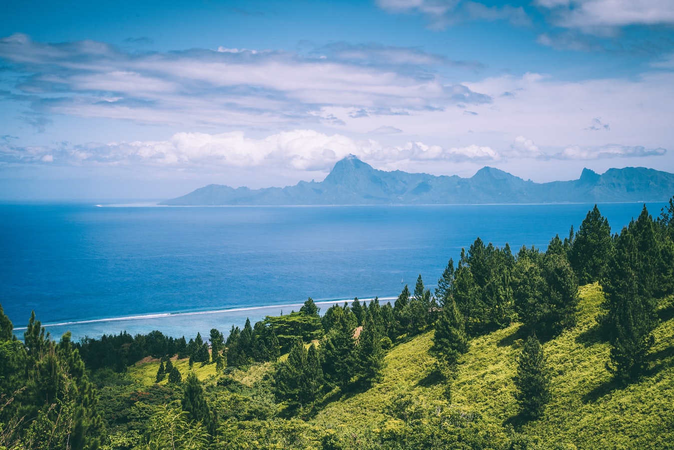
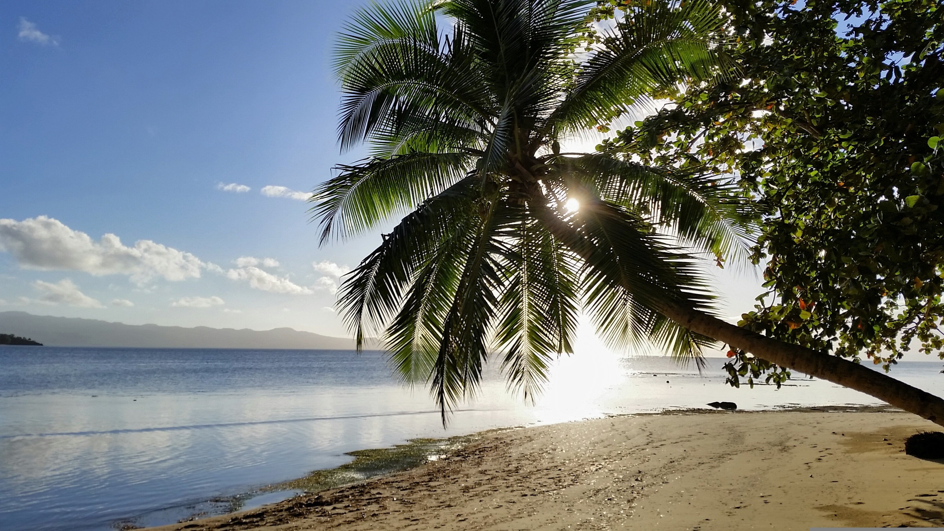
About Papeete, Tahiti
Papeete will be your gateway to the tropical paradise of French Polynesia, where islands fringed with gorgeous beaches and turquoise ocean await to soothe the soul. This spirited city is the capital of French Polynesia, and serves as a superb base for onward exploration of Tahiti – an island of breathtaking landscapes and oceanic vistas. Wonderful lagoons of crisp, clear water beg to be snorkelled, stunning black beaches and blowholes pay tribute to the island's volcanic heritage, and lush green mountains beckon you inland on adventures, as you explore extraordinary Tahiti. Visit to relax inside picturesque stilted huts, which stand out over shimmering water, as you settle into the intoxicating rhythm of life, in this Polynesian paradise.
About Aitutaki
Even high praise like the 'world's most beautiful island' from Lonely Planet's co-founder, Tony Wheeler, won't prepare you for the intoxicating intensity of the coal blue ocean, the glow of the pure white sand, and the soothing ripple of the palm-tree forests at incredible Aitutaki. Breathless romance hangs thick in the air here, especially when a riot of purples, reds and oranges are spreading across the sky, accompanying the sun's descent each evening. It wasn't until 1789 that Europeans discovered this island haven, with the HMS Bounty's crew arriving, just a few weeks before a mutiny tore them apart. The Europeans were beaten to the islands, however, by the streamlined wooden canoes of the Polynesian settlers, who arrived around 900AD. While Western missionaries would eventually visit to spread Christianity to the island - evidenced by the white, coral-encrusted walls of the many churches - their efforts to repress the people’s deep love of communal singing and dancing ultimately failed, and music forms a key component of the islanders' culture to this day.The beaches here are flawless, and swaying in a hammock, suspended between leaning palm trees, as the ocean gently ruffles the sand nearby, feels gloriously indulgent. Aitutaki Lagoon is a huge aquamarine pool of water, alive with a kaleidoscopic swirl of tropical fish, which lurk just below the surface. You may even be lucky enough to spot turtles padding across the sand, scraping themselves towards the open ocean.The snorkelling opportunities here, and on One Foot Island - where you'll want to acquire the badge of honour of having your passport stamped with the island's iconic huge footprint - are sublime. Don't miss the tiny island of Moturakau either, which is crammed full of exotic birds and crabs, who have dominion over the island's tangled, jungle terrain.
About Nuku'alofa
Nukualofa is the capital city of the Kingdom of Tonga, a group of islands in the South Pacific. The islands of Tonga are lined with coral reefs and white sand beaches, and are protected by picturesque lagoons and limestone cliffs. Tonga is also one of the very few places in the world where visitors have the opportunity to swim with whales in the tropical ocean waters.
About Savusavu
Suva, a multiracial city, is the pulsing heart of the South Pacific. Its location is on a hilly peninsula in the southeast corner of Viti Levu Island, the largest in the Fijian archipelago. Suva was named the country's capital in 1882; the former capital was Luvuka. Suva's natural harbour was no doubt a deciding factor that prompted the change. Its port is the country's main shipping facility, accommodating vessels from all over the world. The town is backed by the lush green hills of the Suva-Rewa range. The waterfront district, much of which is built on land reclaimed from tangled mangrove swamps, provides the hub for much of Suva's activities. The downtown centre is a hodgepodge of high-rise office buildings, colonial houses with second-story verandas, parks and government structures. The northern and western mountains catch the trade winds, with the result being damp conditions year-round and frequent tropical downpours. Despite the ever-present possibility of showers, Suva is an excellent place to explore on foot. Many points of interest are located on Victoria Parade and along tree-shaded Queen Elizabeth Drive. Suva's botanical park is lush with flowering plants, trees and green lawns. In its centre stands the Fiji Museum, where objects reflect 3,000 years of Fijian history. The museum boasts a fine collection of Melanesian artefacts and various exhibits that reflect on Fiji's maritime era. Government House stands on a hillside surrounded by landscaped grounds. A stern, uniformed sentry guards the pillared gate entrance. The monthly Changing of the Guard is executed with almost as much pomp and ceremony as at London's Buckingham Palace. Friendly Fiji will charm you; here Melanesia mixes with Polynesia, ancient India with Oceania and tradition with the modern world. The Fijian greeting "Bula!" is extended warmly to strangers on city streets and country roads. Fiji is one of the South Pacific's most hospitable countries and a holiday destination that has much to offer in recreational activities, shopping and joyous celebrations.
About Mystery Island (Inyeug)
About Nouméa
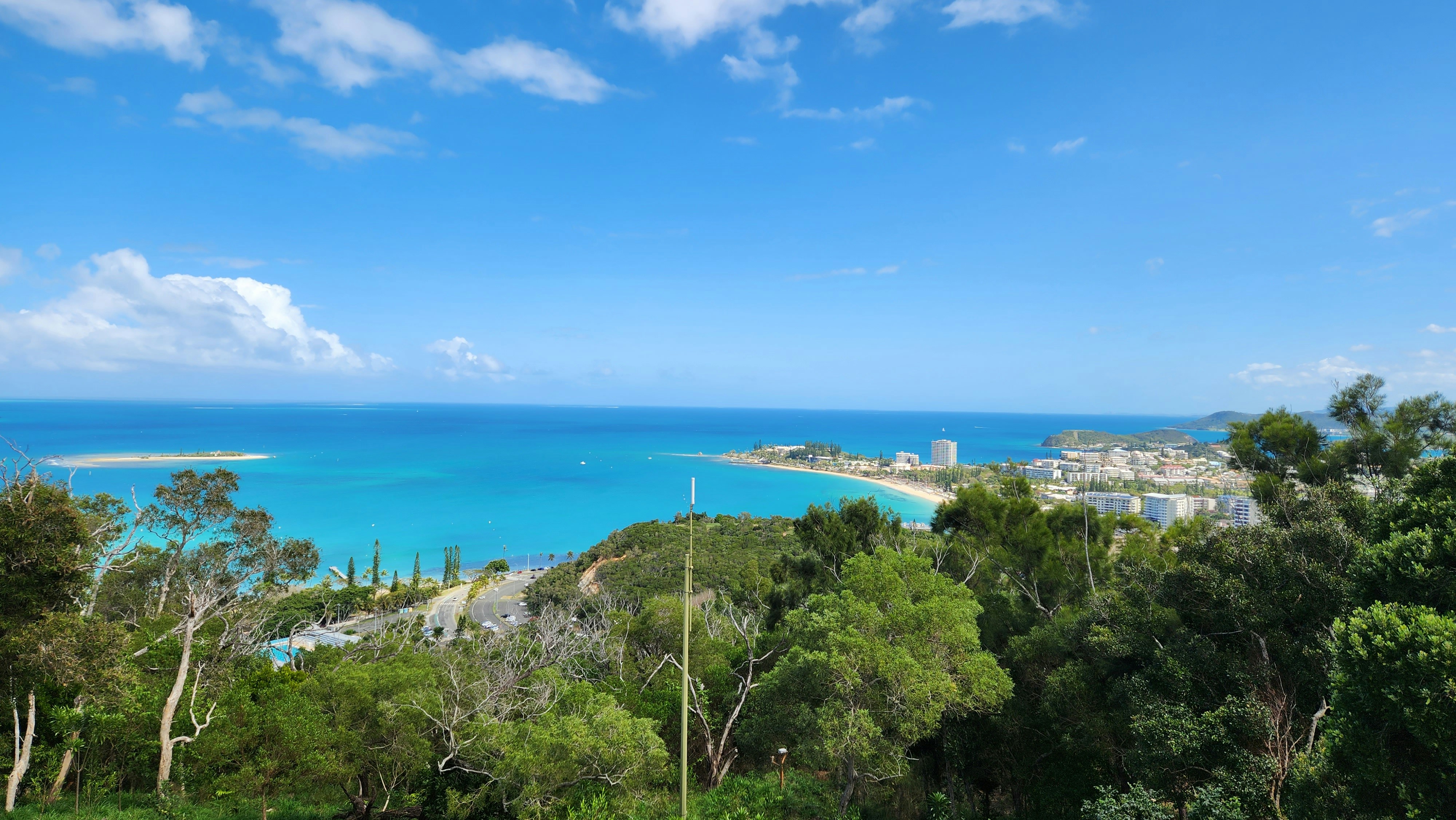
With its elegant urban infrastructure in a stunning natural setting, Noumea is a truly unique island and part of the New Caledonia archipelago. Noumea started as a penal colony, but has since evolved to a lovely metropolis and today has almost two thirds of New Caledonia’s population. While much of the archipelago of New Caledonia has a large percentage of Kanak people – the indigenous inhabitants who live in tribal areas across the country – Noumea is predominantly European with a strong French influence. The city’s center and Place de Cocotiers, the main park, are located close to the harbor and several churches date back to the late 19th century. Other attractions include a world-class aquarium at Anse Vata, several long beaches to the south, and a noteworthy collection of Kanak and South Pacific objects at the Museum of New Caledonia. The architectural gem of the city is the Tjibaou Cultural Center, the structure of which resembles sails, or the roofs of Kanak houses hidden behind mangroves.
About Nouméa
With its elegant urban infrastructure in a stunning natural setting, Noumea is a truly unique island and part of the New Caledonia archipelago. Noumea started as a penal colony, but has since evolved to a lovely metropolis and today has almost two thirds of New Caledonia’s population. While much of the archipelago of New Caledonia has a large percentage of Kanak people – the indigenous inhabitants who live in tribal areas across the country – Noumea is predominantly European with a strong French influence. The city’s center and Place de Cocotiers, the main park, are located close to the harbor and several churches date back to the late 19th century. Other attractions include a world-class aquarium at Anse Vata, several long beaches to the south, and a noteworthy collection of Kanak and South Pacific objects at the Museum of New Caledonia. The architectural gem of the city is the Tjibaou Cultural Center, the structure of which resembles sails, or the roofs of Kanak houses hidden behind mangroves.
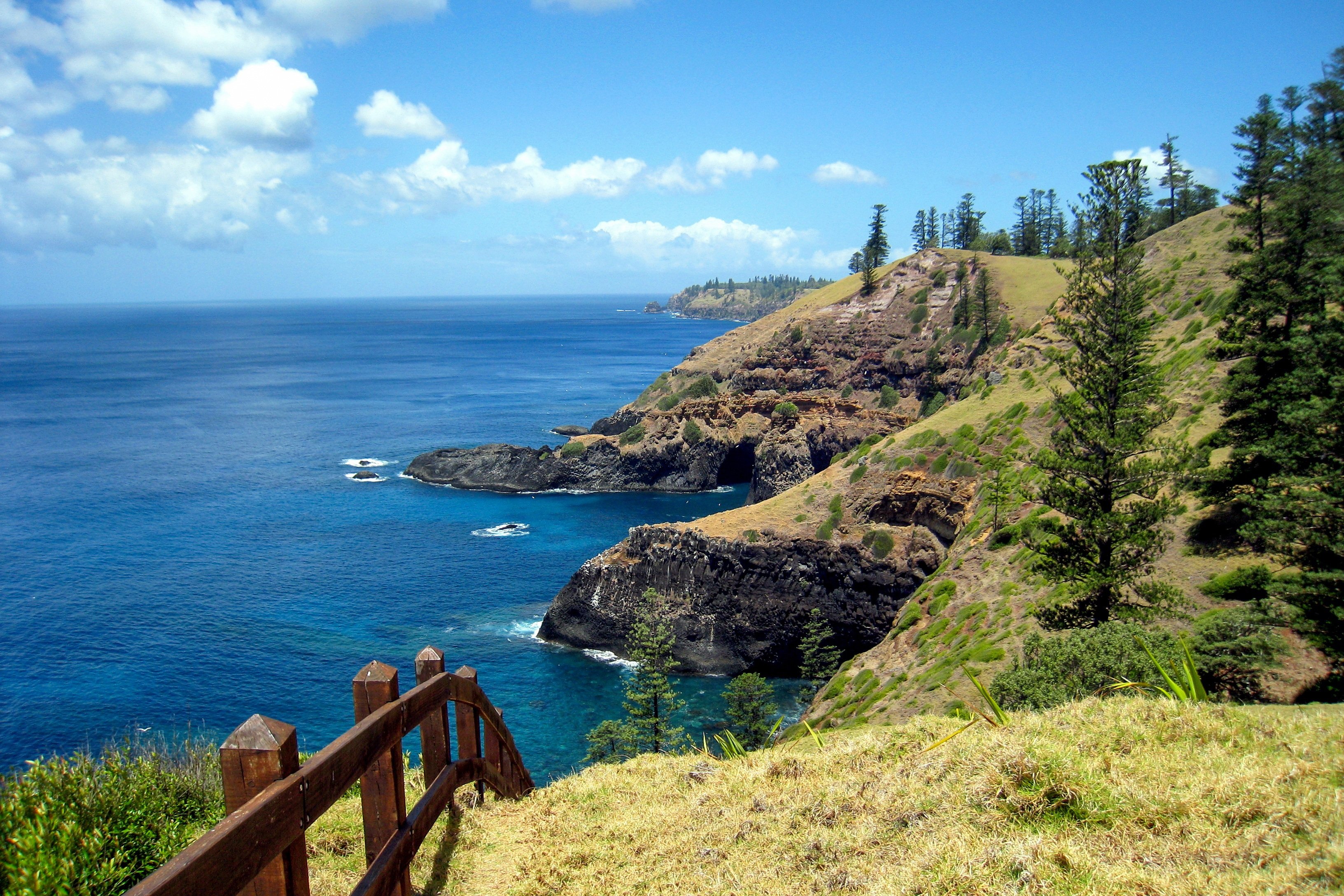
About Norfolk Island
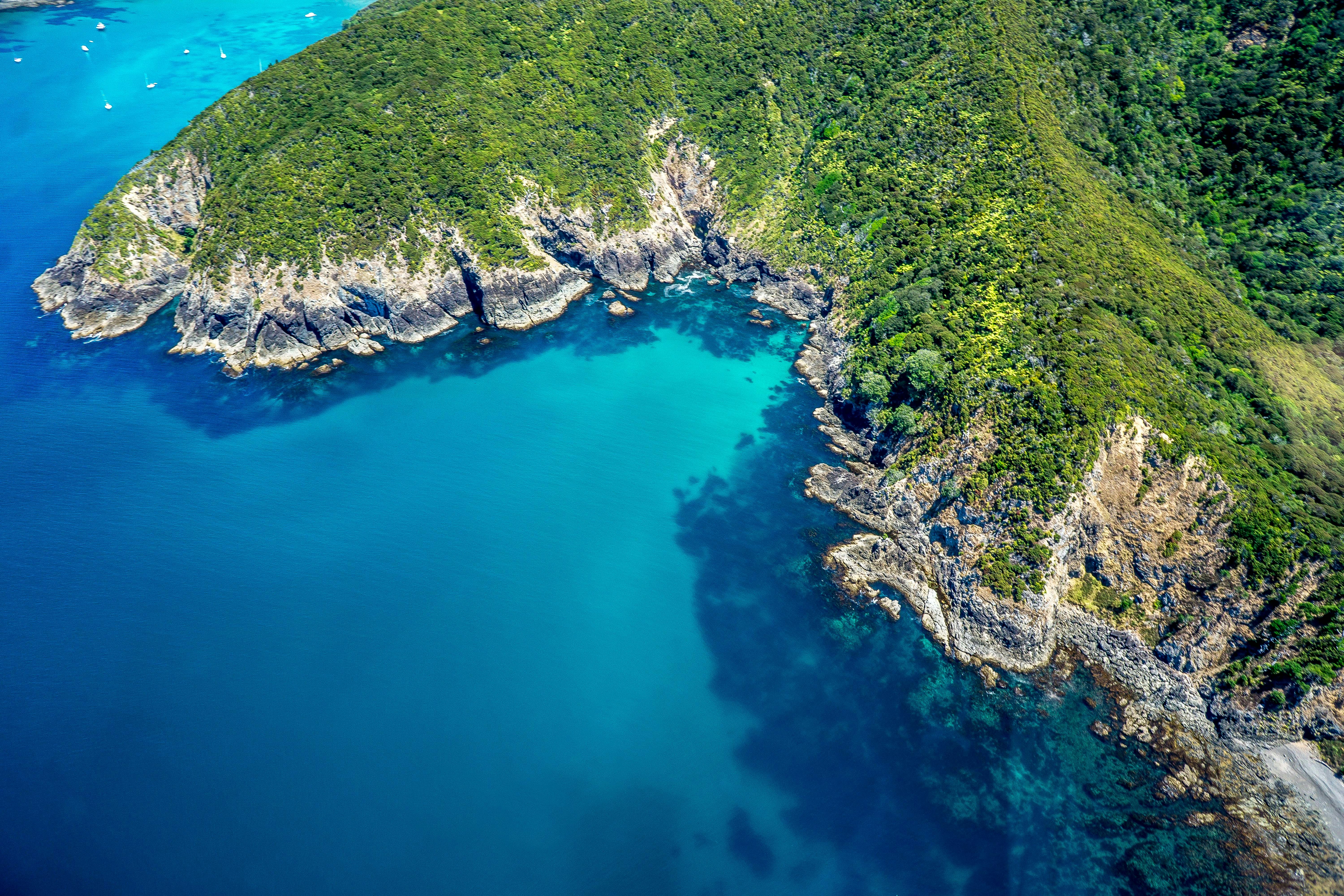
About Bay of Islands
The Tasman Sea on the west and the Pacific Ocean on the east meet at thetop of North Island at Cape Reinga. No matter what route you take, you'll passfarms and forests, marvellous beaches, and great open spaces. The East Coast,up to the Bay of Islands, is Northland's most densely populated, often withrefugees from bigger cities—looking for a more relaxed life—clustered aroundbreathtaking beaches. The first decision on the drive north comes at the footof the Brynderwyn Hills. Turning left will take you up the West Coast throughareas once covered with forests and now used for either agricultural orhorticulture. Driving over "the Brynderwyns," as they are known,takes you to Whangarei, the only city in Northland. If you're in the mood for adiversion, you can slip to the beautiful coastline and take in Waipu Cove, anarea settled by Scots, and Laings Beach, where million-dollar homes sit next tosmall Kiwi beach houses.An hour's drive farther north is the Bay of Islands, known all over theworld for its beauty. There you will find lush forests, splendid beaches, andshimmering harbors. The Treaty of Waitangi was signed here in 1840 betweenMāoriand the British Crown, establishing the basis for the modern New Zealandstate. Every year on February 6, the extremely beautiful Waitangi Treaty Ground(the name means weeping waters) is the sight of a celebration of the treaty andprotests by Māori unhappy with it. Continuing north on the East Coast, theagricultural backbone of the region is even more evident and a series ofwinding loop roads off the main highway will take you to beaches that are bothbeautiful and isolated where you can swim, dive, picnic, or just laze. .The West Coast is even less populated, and the coastline is rugged andwindswept. In the Waipoua Forest, you will find some of New Zealand's oldestand largest kauri trees; the winding road will also take you past mangroveswamps. Crowning the region is the spiritually significant Cape Reinga, theheadland at the top of the vast stretch of 90 Mile Beach, where it's believedMāori souls depart after death. Today Māori make up roughly a quarter of thearea's population (compared with the national average of about 15%). The legendaryMāori navigator Kupe was said to have landed on the shores of Hokianga Harbour,where the first arrivals made their home. Many different wi (tribes) livedthroughout Northland, including Ngapuhi (the largest), Te Roroa, Ngati Wai,Ngati Kuri, Te Aupouri, Ngaitakoto, Ngati Kahu, and Te Rarawa. Many Māoriherecan trace their ancestry to the earliest inhabitants
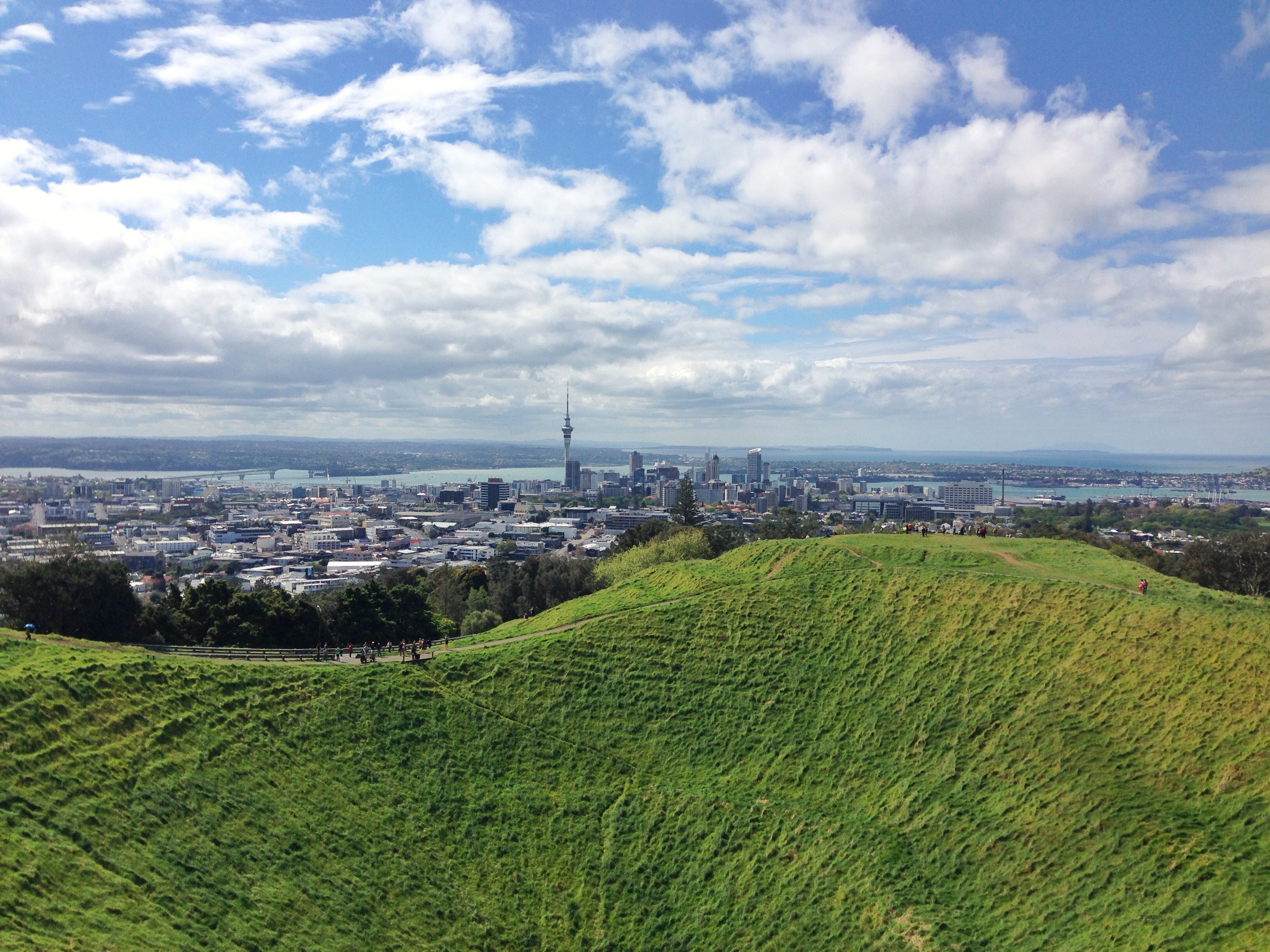
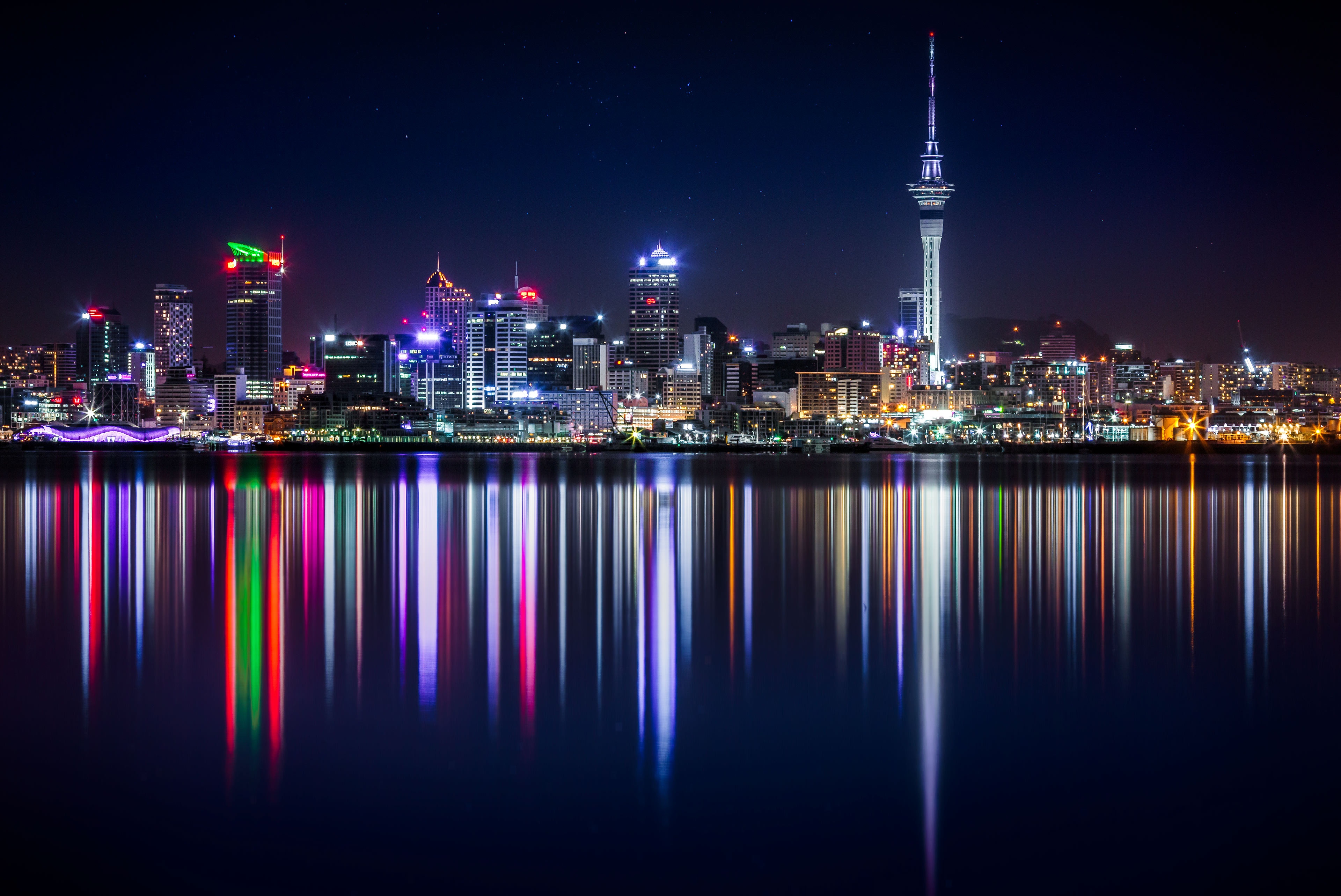
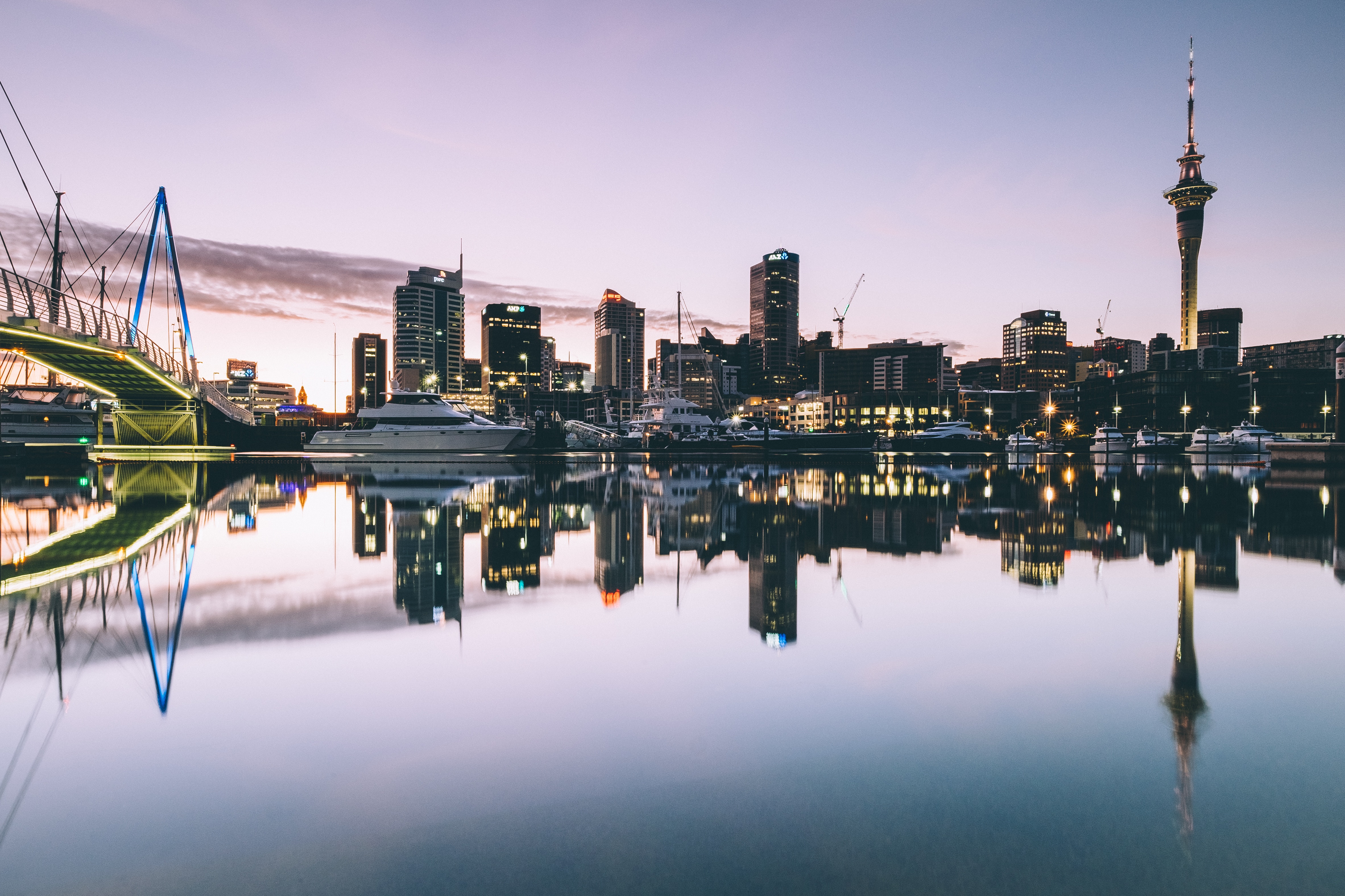
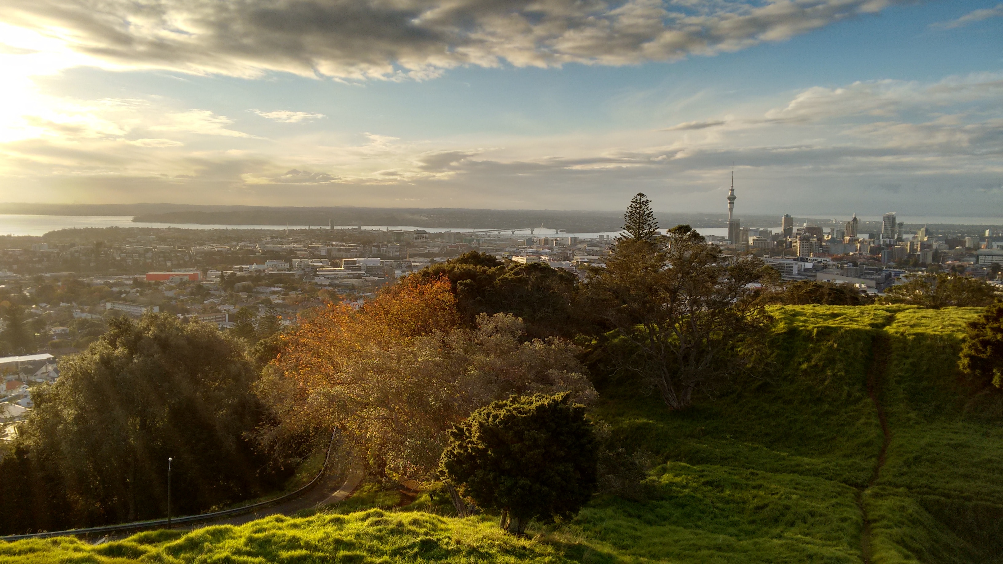
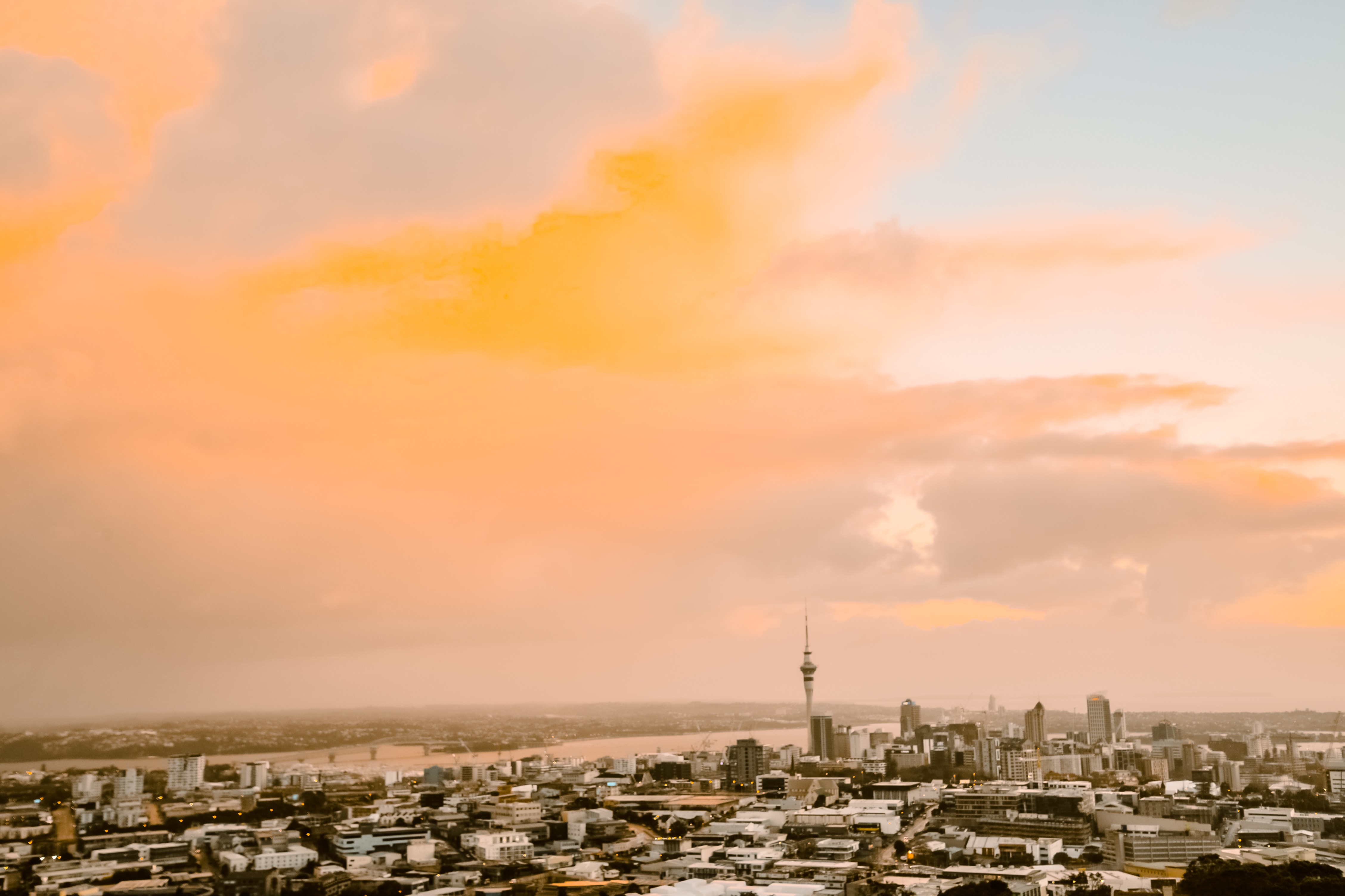
About Auckland
Auckland is called the City of Sails, and visitors flying in will see why. On the East Coast is the Waitemata Harbour—a Māori word meaning sparkling waters—which is bordered by the Hauraki Gulf, an aquatic playground peppered with small islands where many Aucklanders can be found "mucking around in boats."Not surprisingly, Auckland has some 70,000 boats. About one in four households in Auckland has a seacraft of some kind, and there are 102 beaches within an hour's drive; during the week many are quite empty. Even the airport is by the water; it borders the Manukau Harbour, which also takes its name from the Māori language and means solitary bird.According to Māori tradition, the Auckland isthmus was originally peopled by a race of giants and fairy folk. When Europeans arrived in the early 19th century, however, the Ngāti-Whātua tribe was firmly in control of the region. The British began negotiations with the Ngāti-Whātua in 1840 to purchase the isthmus and establish the colony's first capital. In September of that year the British flag was hoisted to mark the township's foundation, and Auckland remained the capital until 1865, when the seat of government was moved to Wellington. Aucklanders expected to suffer from the shift; it hurt their pride but not their pockets. As the terminal for the South Sea shipping routes, Auckland was already an established commercial center. Since then the urban sprawl has made this city of approximately 1.3 million people one of the world's largest geographically.A couple of days in the city will reveal just how developed and sophisticated Auckland is—the Mercer City Survey 2012 saw it ranked as the third-highest city for quality of life—though those seeking a New York in the South Pacific will be disappointed. Auckland is more get-up and go-outside than get-dressed-up and go-out. That said, most shops are open daily, central bars and a few nightclubs buzz well into the wee hours, especially Thursday through Saturday, and a mix of Māori, Pacific people, Asians, and Europeans contributes to the cultural milieu. Auckland has the world's largest single population of Pacific Islanders living outside their home countries, though many of them live outside the central parts of the city and in Manukau to the south. The Samoan language is the second most spoken in New Zealand. Most Pacific people came to New Zealand seeking a better life. When the plentiful, low-skilled work that attracted them dried up, the dream soured, and the population has suffered with poor health and education. Luckily, policies are now addressing that, and change is slowly coming. The Pacifica Festival in March is the region's biggest cultural event, attracting thousands to Western Springs. The annual Pacific Island Secondary Schools’ Competition, also in March, sees young Pacific Islander and Asian students compete in traditional dance, drumming, and singing. This event is open to the public.At the geographical center of Auckland city is the 1,082-foot Sky Tower, a convenient landmark for those exploring on foot and some say a visible sign of the city's naked aspiration. It has earned nicknames like the Needle and the Big Penis—a counterpoint to a poem by acclaimed New Zealand poet James K. Baxter, which refers to Rangitoto Island as a clitoris in the harbor.The Waitemata Harbour has become better known since New Zealand staged its first defense of the America's Cup in 2000 and the successful Louis Vuitton Pacific Series in early 2009. The first regatta saw major redevelopment of the waterfront. The area, where many of the city's most popular bars, cafés, and restaurants are located, is now known as Viaduct Basin or, more commonly, the Viaduct. A recent expansion has created another area, Wynyard Quarter, which is slowly adding restaurants.These days, Auckland is still considered too bold and brash for its own good by many Kiwis who live "south of the Bombay Hills," the geographical divide between Auckland and the rest of New Zealand (barring Northland). "Jafa," an acronym for "just another f—ing Aucklander," has entered the local lexicon; there's even a book out called Way of the Jafa: A Guide to Surviving Auckland and Aucklanders. A common complaint is that Auckland absorbs the wealth from the hard work of the rest of the country. Most Aucklanders, on the other hand, still try to shrug and see it as the parochial envy of those who live in small towns. But these internal identity squabbles aren't your problem. You can enjoy a well-made coffee in almost any café, or take a walk on a beach—knowing that within 30 minutes' driving time you could be cruising the spectacular harbor, playing a round at a public golf course, or even walking in subtropical forest while listening to the song of a native tûî bird.
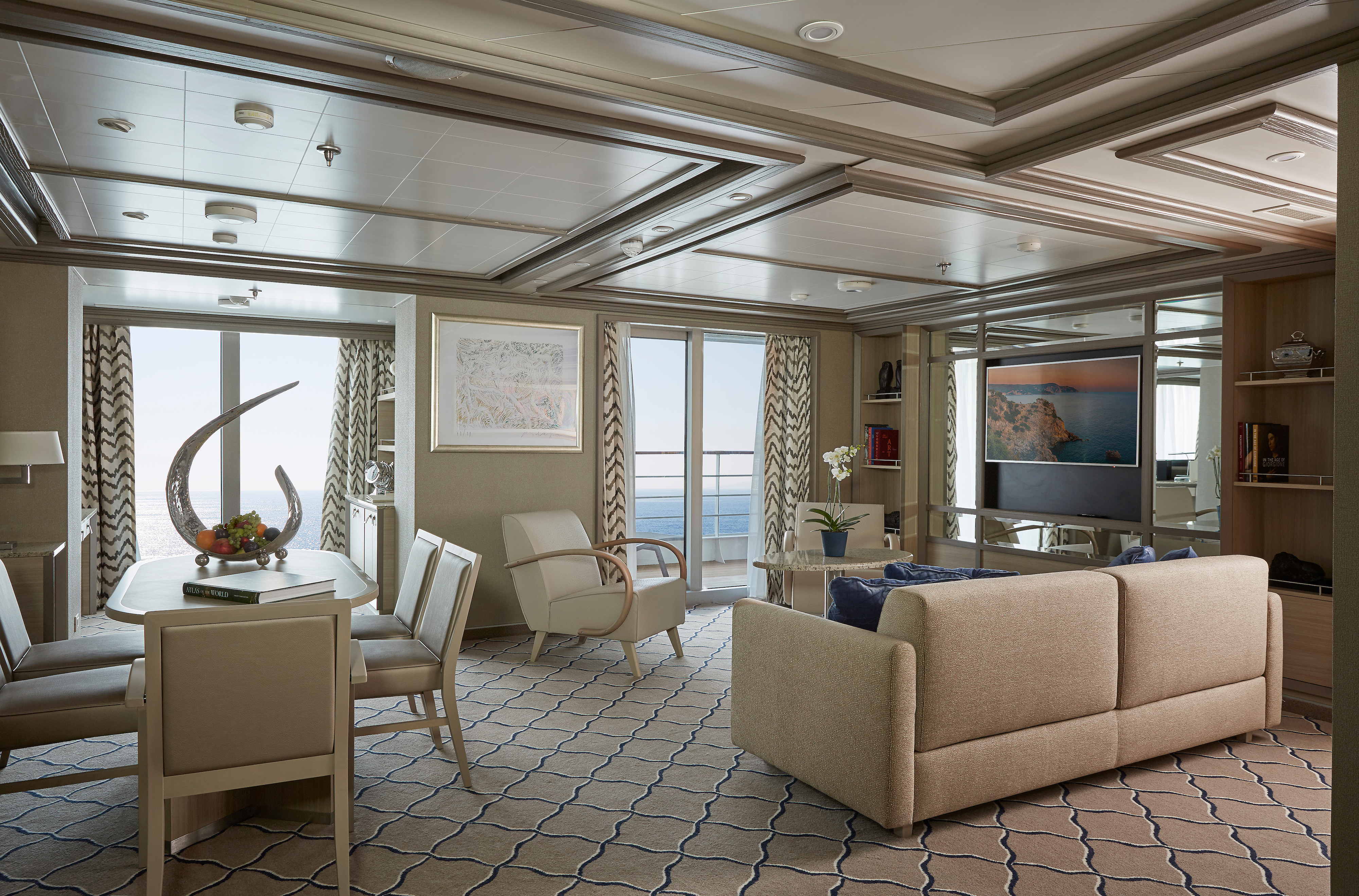
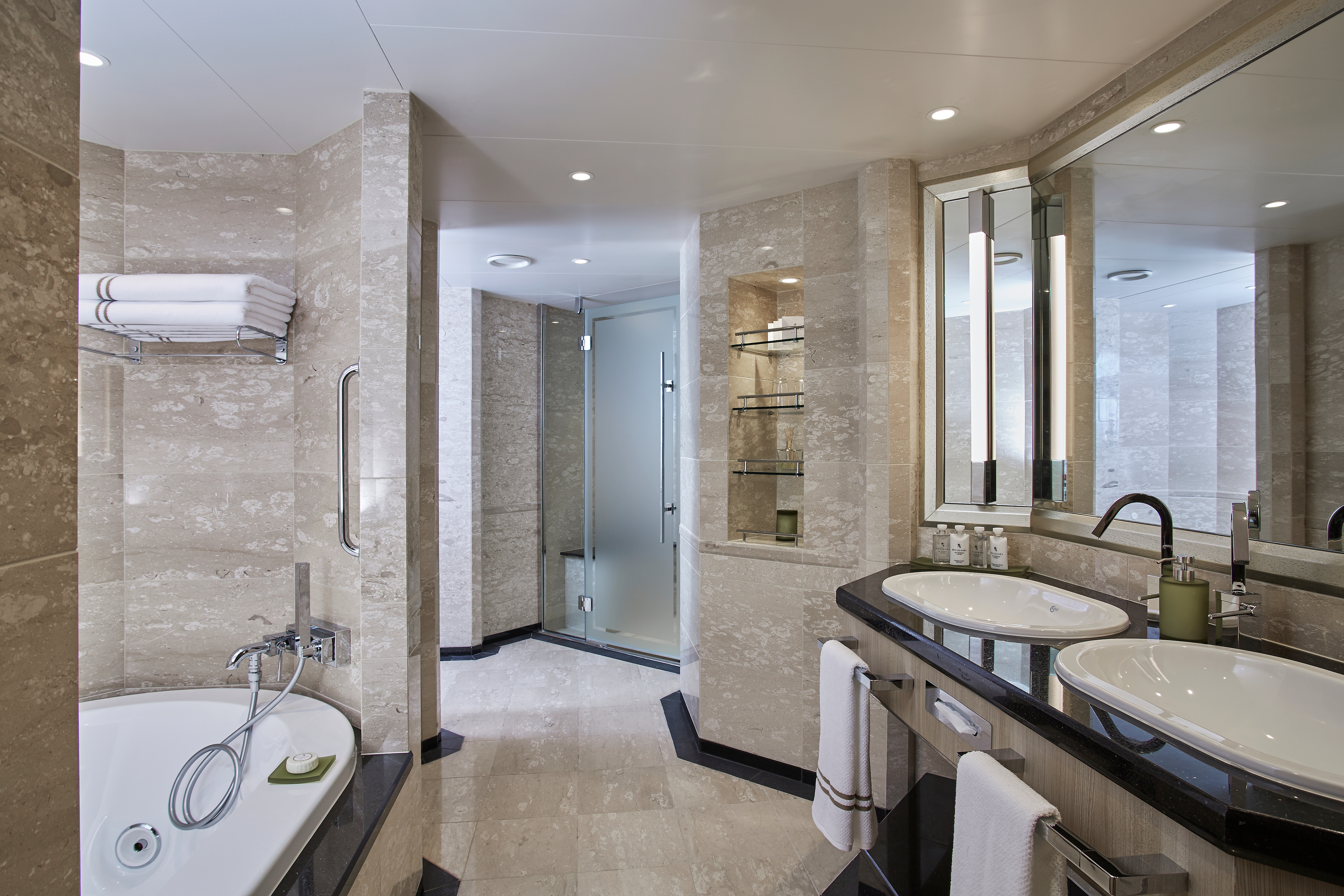
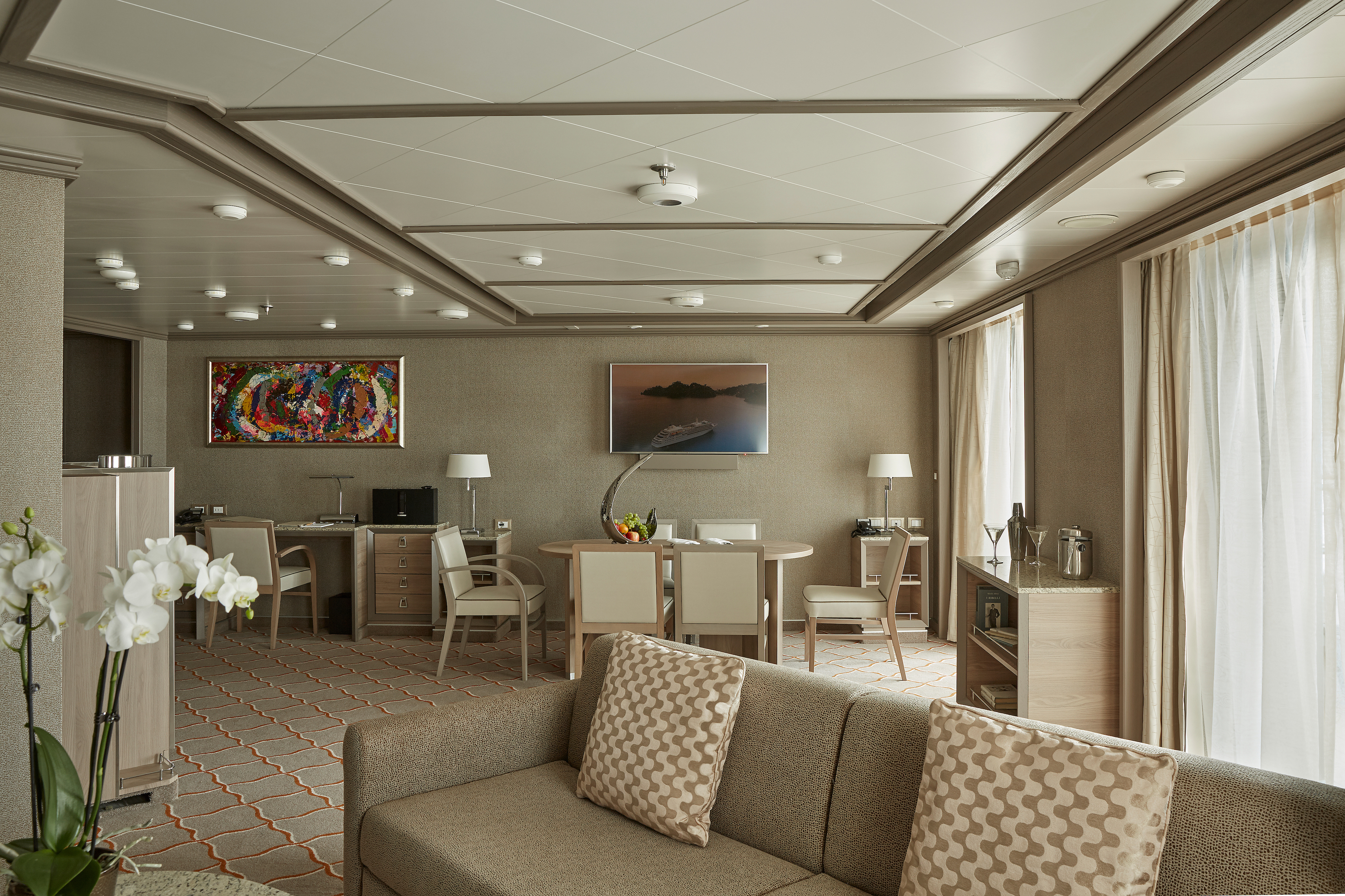
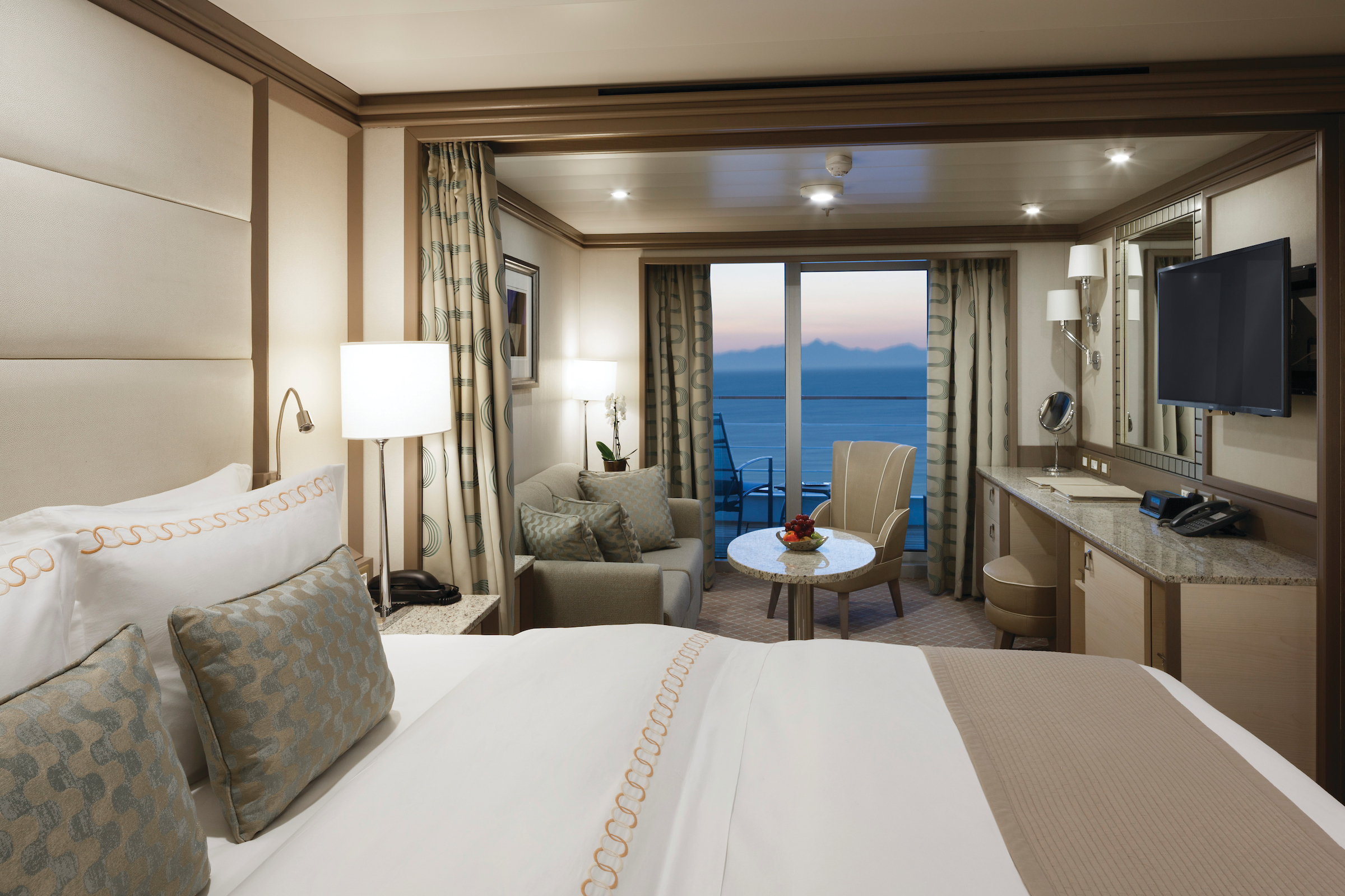
Available in a one- or two-bedroom configuration (so perfect for families), the Owner’s suite is the epitome of elegance at sea. A large seating area is the hub of the suite, equipped with all modern conveniences—think a Bose sound system, an interactive 55″ TV, and even an Illy coffee machine! Whether you are inside or relaxing on the large teak veranda, the Owner’s suite offers supreme comfort every hour of the day!
One bedroom: 88–98 sq m including veranda (12 sq m)
Two bedrooms: 119–129 sq m including veranda* (12 sq m )
*The difference in size is largely due to a larger entry corridor and does not affect the living or sleeping area.
Images are intended as a general reference. Features, materials, finishes and layout may be different than shown.
Please note that the third guest will sleep on a comfortable sofa bed in the reception area of the suite.
Essentials
- Deck(s): 9
- Section: Mid-Ship
Characteristics
- Veranda
- Separate dining area
- Living room with sitting area
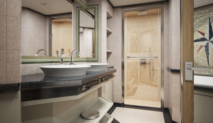
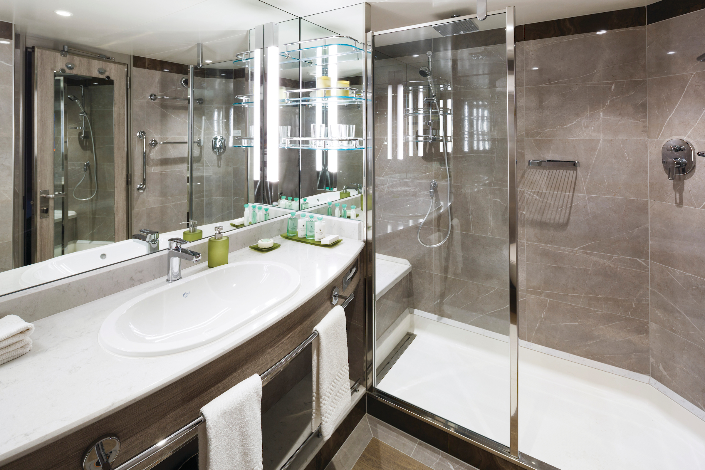
- Double vanity
- Separate shower
- Whirlpool bath
- Walk-in wardrobe with personal safe
Furniture
- King size bed
- Writing desk
- Vanity table
- Luxury bed mattresses
Media & Communication
- Unlimited Premium Wi-Fi
- 2 large flat screen TVs with Interactive Media Library
- Sound system with bluetooth connectivity
- Direct dial telephone
- Wall mounted USB-C mobile device chargers
- Dual voltage 110/220 outlets
Onboard Services
- Butler service
- Complimentary laundry, pressing & wet cleaning
- Dinner for two in La Dame, one evening per voyage,
- Two hours of worldwide phone use, per voyage segment
- Champagne on arrival
Amenities
- Espresso machine
- Pillow menu
- Refrigerator and bar setup stocked with your preferences
- Plush bathrobe
- Luxury bath amenities
- Umbrella
- Hair Dryer
- Slippers
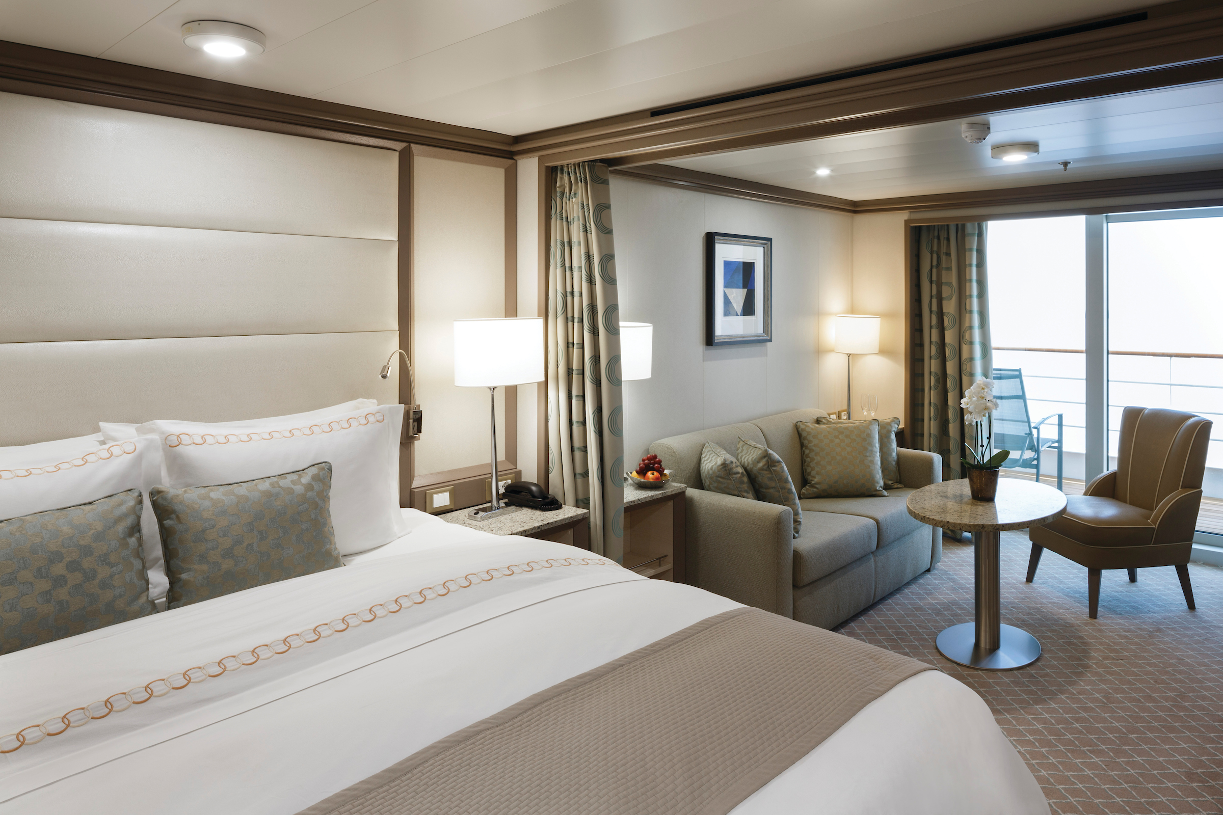
A grand traveler needs a grand suite, and we are happy to oblige! Get ready to scale new heights of comfort in our ultra-luxury Grand Suite. Situated at the front of the ship for the most spectacular views, the Grand Suite is for travelers who like the finer things in life. A large veranda, furnished with sun beds, makes for perfect memories. Indoors, the sumptuous seating area and cozy bedrooms are the very definition of relaxing in style.
One bedroom: 137–146 sq m including veranda (44–53 sq m)
Two bedrooms: 174–183 sq m including veranda (50–59 sq m)
Images are intended as a general reference. Features, materials, finishes and layout may be different than shown.
Please note that the 3rd guest will sleep on a comfortable sofa bed in the reception area of the suite.
Essentials
- Deck(s): 8, 9
- Section: Forward
Characteristics
- Veranda
- Separate dining area
- Living room with sitting area
- Double vanity
- Separate shower
- Whirlpool bath
- Walk-in wardrobe with personal safe
Furniture
- King size bed
- Writing desk
- Vanity table
- Luxury bed mattresses
Media & Communication
- Unlimited Premium Wi-Fi
- 2 large flat screen TVs with Interactive Media Library
- Sound system with bluetooth connectivity
- Direct dial telephone
- Wall mounted USB-C mobile device chargers
- Dual voltage 110/220 outlets
Onboard Services
- Butler service
- Complimentary laundry, pressing & wet cleaning
- Dinner for two in La Dame, one evening per voyage,
- Two hours of worldwide phone use, per voyage segment
- Champagne on arrival
Amenities
- Espresso machine
- Pillow menu
- Refrigerator and bar setup stocked with your preferences
- Plush bathrobe
- Luxury bath amenities
- Umbrella
- Hair Dryer
- Slippers

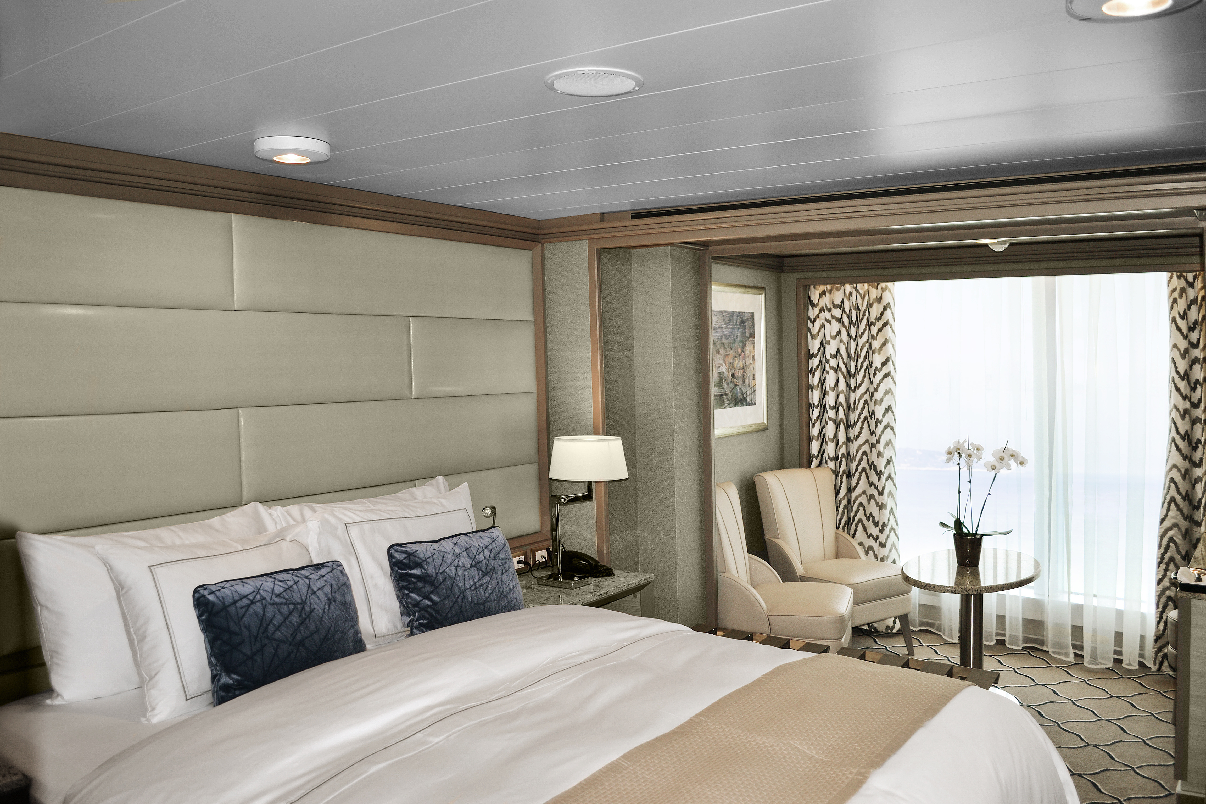
With just two Royal Suites on board, this stateroom is in a class all of its own! Spacious and dignified, commanding and majestic, there’s no secret to why we named this the Royal Suite. Ample indoor space with a living room (including state-of-the-art entertainment systems), twin beds that can be joined upon demand, and even an adjoining bedroom if required—the Royal Suite is the answer when traveling with the family! Not to mention unlimited Wi-Fi, a sumptuous marble bathroom, and spacious teak veranda—the Royal Suite is fit for a king!
One bedroom: 105 sq m including veranda (12 sq m)
Two bedrooms: 142 sq m including veranda (18 sq m )
Images are intended as a general reference. Features, materials, finishes and layout may be different than shown.
Please note that the 3rd guest will sleep on a comfortable sofa bed in the reception area of the suite.
Essentials
- Deck(s): 7
- Section: Forward
Characteristics
- Veranda
- Separate dining area
- Living room with sitting area
- Double vanity
- Separate shower
- Whirlpool bath
- Walk-in wardrobe with personal safe
Furniture
- King size bed
- Writing desk
- Vanity table
- Luxury bed mattresses
Media & Communication
- Unlimited Premium Wi-Fi
- 2 large flat screen TVs with Interactive Media Library
- Sound system with bluetooth connectivity
- Direct dial telephone
- Wall mounted USB-C mobile device chargers
- Dual voltage 110/220 outlets
Onboard Services
- Butler service
- Complimentary laundry, pressing & wet cleaning
- Dinner for two in La Dame, one evening per voyage,
- Two hours of worldwide phone use, per voyage segment
- Champagne on arrival
Amenities
- Espresso machine
- Pillow menu
- Refrigerator and bar setup stocked with your preferences
- Plush bathrobe
- Luxury bath amenities
- Umbrella
- Hair Dryer
- Slippers
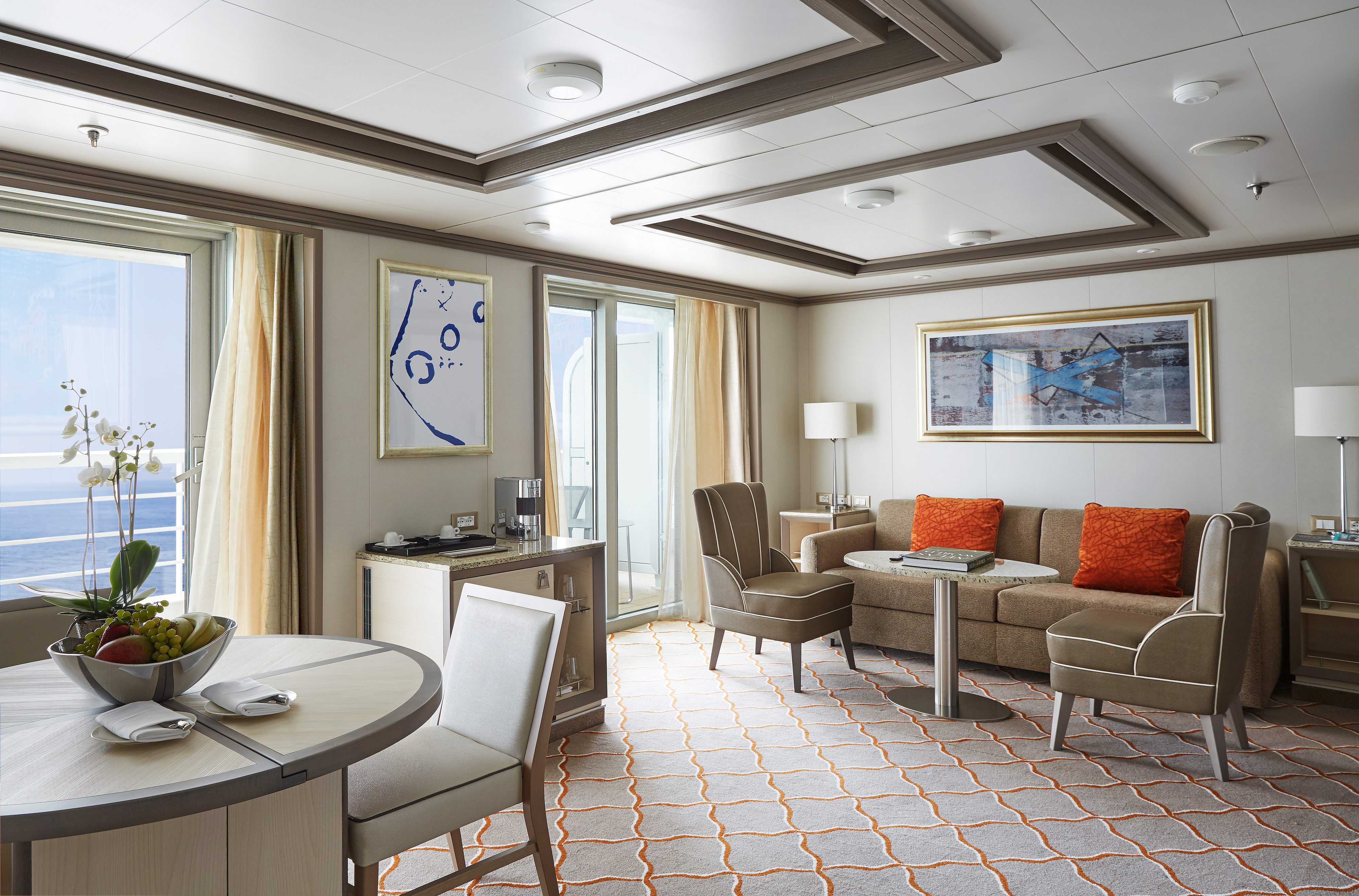
A Silversea favorite and by far our best-selling suite! The Silver Suite is one of the foundations of ultra-luxury cruising. Take traveling to a whole new level with the Silver Suite’s unparalleled levels of service, comfort, and of course, style! Available in either a one-bedroom, a two-bedroom, or wheelchair accessible configuration, Silver Suites are fully equipped for the discerning traveler. Whether enjoying the spectacular views from the veranda or relaxing in the large sitting room, Silver Suites offer a comfortable haven on the high seas.
One bedroom: 73 sq m including veranda (12 sq m)
Two bedrooms: 104 sq m including veranda (12 sq m)
Wheelchair accessible suite: 931
Images are intended as a general reference. Features, materials, finishes and layout may be different than shown.
Please note that the 3rd guest will sleep on a comfortable sofa bed in the reception area of the suite.
Essentials
- Deck(s): 9, 10, 11
- Section: Forward, Mid-Ship
Characteristics
- Veranda
- Living room with sitting area
- Double vanity
- Separate shower
- Whirlpool bath
- Walk-in wardrobe with personal safe
Furniture
- King size bed
- Writing desk
- Vanity table
- Luxury bed mattresses
Media & Communication
- Unlimited Premium Wi-Fi
- 2 large flat screen TVs with Interactive Media Library
- Sound system with bluetooth connectivity
- Direct dial telephone
- Wall mounted USB-C mobile device chargers
- Dual voltage 110/220 outlets
Onboard Services
- Butler service
- Complimentary laundry, pressing & wet cleaning
- Champagne on arrival
Amenities
- Espresso machine
- Pillow menu
- Refrigerator and bar setup stocked with your preferences
- Plush bathrobe
- Luxury bath amenities
- Umbrella
- Hair Dryer
- Slippers
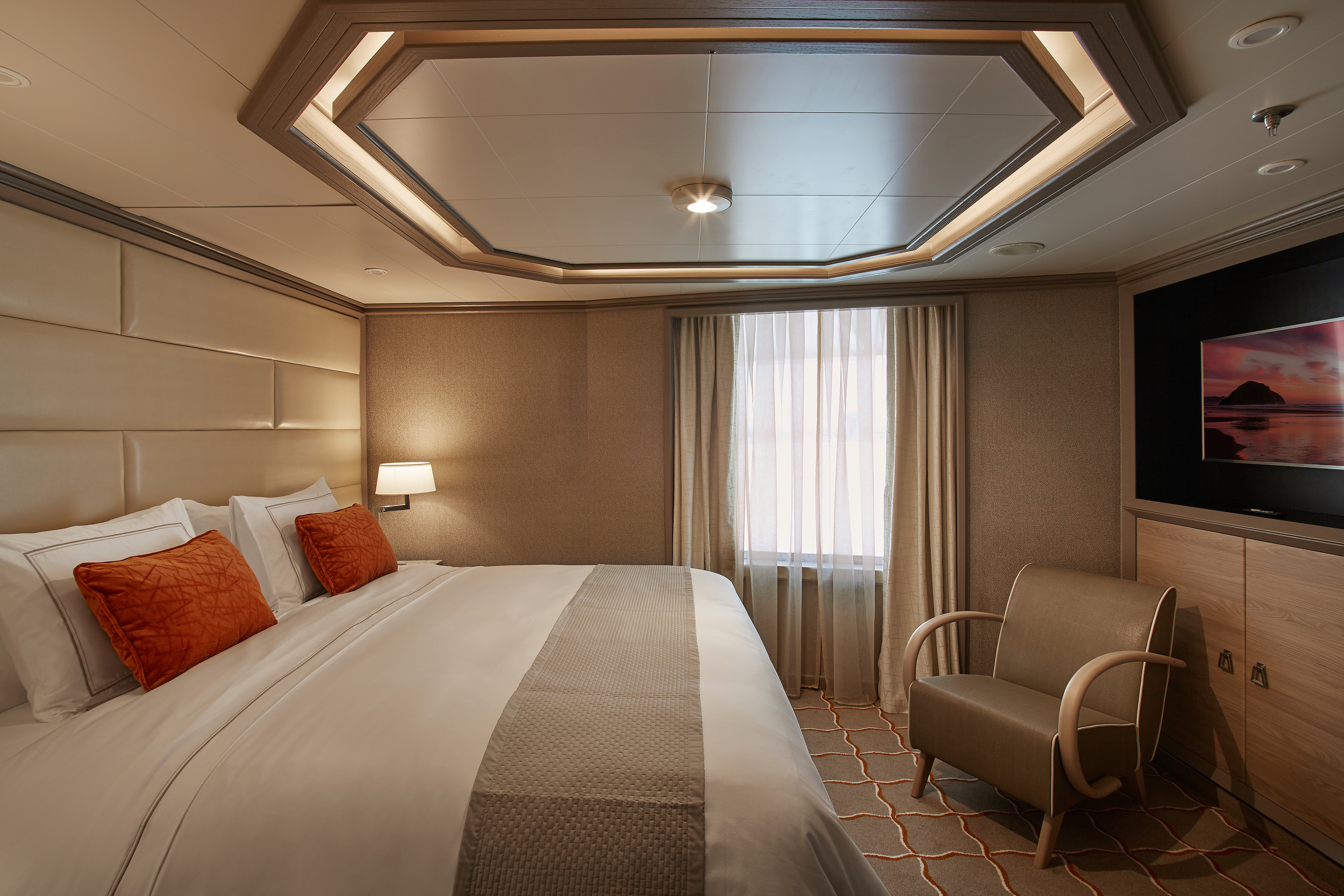
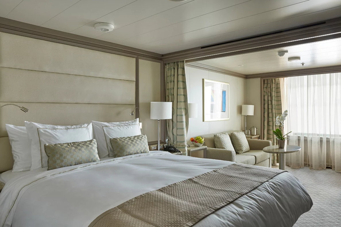
After a busy day of onshore exploring, the Deluxe Veranda Suite is the perfect home away from home. Spacious and well-situated, enjoy ultra-luxury amenities from the 24-hour butler service to the well-stocked mini-bar (and yes, they’re all included!). Not forgetting the teak veranda from which the suite takes her name, the Deluxe Veranda is the perfect setting for making perfect memories.
One bedroom: 36 sq m including veranda (6 sq m)
Images are intended as a general reference. Features, materials, finishes and layout may be different than shown.
Please note that the 3rd guest will sleep on a comfortable sofa bed in the reception area of the suite.
Essentials
- Deck(s): 6, 7, 8
- Section: Mid-Ship
Characteristics
- Veranda
- Sitting area
- Standard vanity
- Separate shower
- Full-size bath
- Walk-in wardrobe with personal safe
Furniture
- Queen size bed
- Writing desk
- Luxury bed mattresses
Media & Communication
- Unlimited Standard Wi-Fi
- 1 large flat screen TV with Interactive Media Library
- Direct dial telephone
- Wall mounted USB-C mobile device chargers
- Dual voltage 110/220 outlets
Onboard Services
- Butler service
- Champagne on arrival
Amenities
- Pillow menu
- Refrigerator and bar setup stocked with your preferences
- Plush bathrobe
- Luxury bath amenities
- Umbrella
- Hair Dryer
- Slippers
A superior location makes the Superior Veranda Suite, well … superior! From the sumptuous views from the teak veranda to the spacious sitting room and large marble bathroom, everything about the Superior Veranda has been designed for your comfort. So settle in and get comfortable, order some 24-hour room service from your butler and enjoy a bit of R&R. We guarantee you won’t want to leave.
One bedroom: 36 sq ft including veranda (6 sq m)
Images are intended as a general reference. Features, materials, finishes and layout may be different than shown.
Please note that the third guest will sleep on a comfortable sofa bed in the reception area of the suite.
Essentials
- Deck(s): 7, 8, 9
- Section: Forward
Characteristics
- Veranda
- Sitting area
- Standard vanity
- Separate shower
- Full-size bath
- Walk-in wardrobe with personal safe
Furniture
- Queen size bed
- Writing desk
- Luxury bed mattresses
Media & Communication
- Unlimited Standard Wi-Fi
- 1 large flat screen TV with Interactive Media Library
- Direct dial telephone
- Wall mounted USB-C mobile device chargers
- Dual voltage 110/220 outlets
Onboard Services
- Butler service
- Champagne on arrival
Amenities
- Pillow menu
- Refrigerator and bar setup stocked with your preferences
- Plush bathrobe
- Luxury bath amenities
- Umbrella
- Hair Dryer
- Slippers
A lower-bow location makes the Classic Veranda Suite a comfortable choice for travelers. A lovely, comfortable bed—available in a twin- or queen-bed configuration—with a choice of mattress ensures that you enjoy the best night’s sleep of your life while the seating area is perfect for in-suite dining. But perhaps the Classic Veranda’s best feature lies outside the suite—with the 6-m2 (64-sq-ft) veranda for which the suite was named.
One bedroom: 36 sq m including veranda (6 sq m)
Images are intended as a general reference. Features, materials, finishes and layout may be different than shown.
Essentials
- Deck(s): 5, 6
- Section: Forward
Characteristics
- Veranda
- Sitting area
- Standard vanity
- Separate shower
- Full-size bath
- Walk-in wardrobe with personal safe
Furniture
- Queen size bed
- Writing desk
- Luxury bed mattresses
Media & Communication
- Unlimited Standard Wi-Fi
- 1 large flat screen TV with Interactive Media Library
- Direct dial telephone
- Wall mounted USB-C mobile device chargers
- Dual voltage 110/220 outlets
Onboard Services
- Butler service
- Champagne on arrival
Amenities
- Pillow menu
- Refrigerator and bar setup stocked with your preferences
- Plush bathrobe
- Luxury bath amenities
- Umbrella
- Hair Dryer
- Slippers
Beautiful elegant furnishings are the perfect choice to soothe and relax as you sail from one destination to the next. Large windows flood the room with light, making for luxurious ocean views whether it’s morning, noon, or night! Panorama Suites are the perfect accompaniment to a Silver Suite for larger parties, or just perfect on their own. With all the modern conveniences that you would expect from an ultra-luxury cruise line, Panorama Suites offer comfort, space, and style!
One bedroom: 31 sq m
Images are intended as a general reference. Features, materials, finishes and layout may be different than shown.
Essentials
- Deck(s): 9
- Section: Forward
Characteristics
- Floor-to ceiling window
- Sitting area
- Standard vanity
- Separate shower
- Full-size bath
- Walk-in wardrobe with personal safe
Furniture
- Queen size bed
- Writing desk
- Luxury bed mattresses
Media & Communication
- Unlimited Standard Wi-Fi
- 1 large flat screen TV with Interactive Media Library
- Direct dial telephone
- Wall mounted USB-C mobile device chargers
- Dual voltage 110/220 outlets
- Butler service
- Champagne on arrival
Amenities
- Pillow menu
- Refrigerator and bar setup stocked with your preferences
- Plush bathrobe
- Luxury bath amenities
- Umbrella
- Hair Dryer
- Slippers
Comfortable, spacious, and offering stupendous ocean views, the Vista Suite carries its name very well! Wake up to wide ocean views, eat breakfast to the sound of the waves lapping at the side of the ship, or simply relax with the in-suite entertainment system and comfy sofas. Some Vista Suites are a little larger than standard—perfect for our guests with limited mobility. If you have ever wanted a home away from home on the high seas, the Vista Suite is it.
One bedroom: 32 sq m
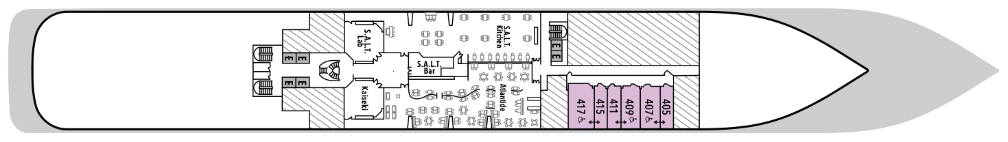
Wheelchair accessible suites: 407, 409, 417
Images are intended as a general reference. Features, materials, finishes and layout may be different than shown.
Essentials
- Deck(s): 4
- Section: Forward
Characteristics
- Window
- Sitting area
- Standard vanity
- Separate shower
- Full-size bath
- Walk-in wardrobe with personal safe
Furniture
- Queen size bed
- Writing desk
- Luxury bed mattresses
Media & Communication
- Unlimited Standard Wi-Fi
- 1 large flat screen TV with Interactive Media Library
- Direct dial telephone
- Wall mounted USB-C mobile device chargers
- Dual voltage 110/220 outlets
Onboard Services
- Butler service
- Champagne on arrival
Amenities
- Pillow menu
- Refrigerator and bar setup stocked with your preferences
- Plush bathrobe
- Luxury bath amenities
- Umbrella
- Hair Dryer
- Slippers
Silver Dawn
A new world of luxury is waiting aboard Silver Dawn. Elegant and modern, Silver Dawn is the natural evolution of our fleet. Large enough to offer eight dining options—including the superb Sea and Land Taste (S.A.L.T.) program—yet small enough for the famed Silversea onboard ambience, Silver Dawn inherits the best features of her sister ships Silver Muse and Silver Moon, but is in a class all of her own. With sumptuous suites, outstanding itineraries, plus cutting-edge design and technology, and the outstanding OTIVM wellness concept, Silver Dawn sets new standards of luxury. Wake up to a new dawn with Silversea.
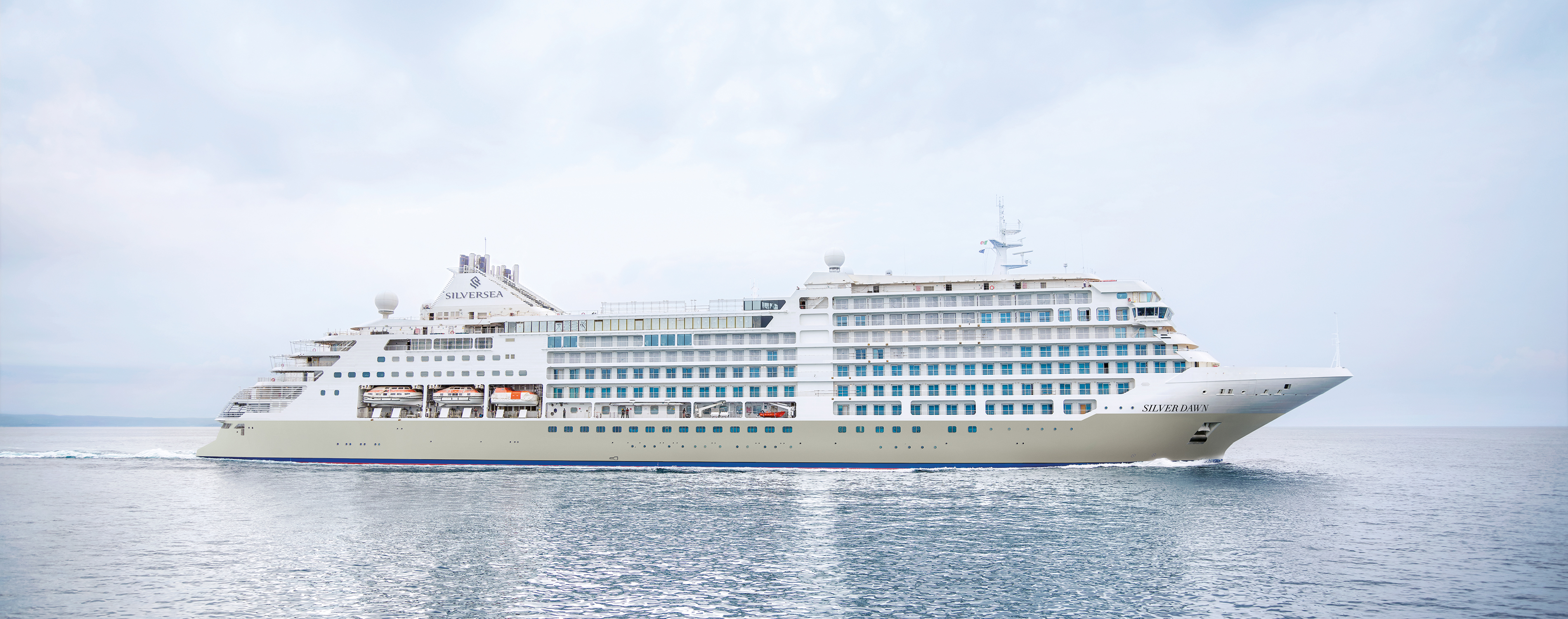
Ship Facts
| Launch Year | 2022 | ||||||||||
| Refit Year | |||||||||||
| Language | en | ||||||||||
| Gross Tonnage | 40700 | ||||||||||
| Length | 213 | ||||||||||
| Width | 26 | ||||||||||
| Currency | USD | ||||||||||
| Speed | 20 | ||||||||||
| Capacity | 596 | ||||||||||
| Crew Count | 411 | ||||||||||
| Deck Count | 8 | ||||||||||
| Cabin Count | 288 | ||||||||||
| Large Cabin Count | N/A | ||||||||||
| Wheelchair Cabin Count | 4 | ||||||||||
| Electrical Plugs |
|
Deck 11
- Observation Library
- Spaccanapoli
- Jogging Track
- Silver Suites
- Elevator

Deck 10
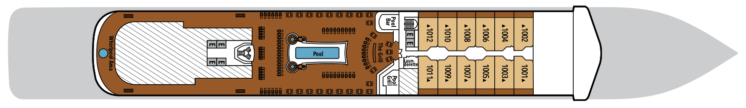
- Pool Deck
- Pool Bar
- Launderette
- The Grill
- Whirlpool Area
- Silver Suite
- Elevator
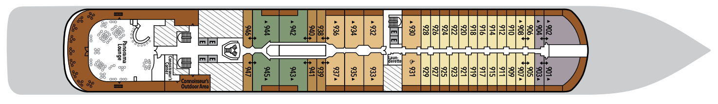
Deck 9
- Panorama Lounge
- Connoisseur's Corner
- Launderette
- Owner's Suite
- Panorama Suite
- Silver Suite
- Superior Veranda Suite
- Grand Suite
- Elevator
Deck 8
- Arts Café
- Boutique
- La Dame
- Launderette
- Deluxe Veranda Suite
- Superior Veranda suite
- Grand Suite
- Elevator
Deck 7
- La Terrazza
- Silver Note
- Casino
- Launderette
- Royal Suite
- Superior Veranda Suite
- Deluxe Veranda Suite
- Elevator
Deck 6
- Otium Spa
- Fitness Centre
- Relaxation Area
- Beauty Salon
- Launderette
- Deluxe Veranda Suite
- Classic Veranda Suite
- Elevator
Deck 5
- Reception/Guest Relations
- Shore Concierge
- Dolce Vita
- Venetian Lounge
- Future Cruise Sales
- Launderette
- Cruise Consultant
- Classic Veranda Suite
- Elevator
Deck 4
- Atlantide
- Kaiseki
- S.A.L.T Kitchen
- S.A.L.T Bar
- S.A.L.T Lab
- Vista Suite (3x Accessible)
- Elevator
With the importance of food in Italian culture you would expect dining to be a high priority at Silversea. And it most assuredly is. Moreover, gastronomic excellence is a given, thanks to our recipes that reflect heritage and revamp tradition. No matter where you dine, destination influence is readily apparent in the great diversity and freshness of your selections. And every ship also features an array of dining venues. The main dining room, The Restaurant, is an open-seating venue where you can dine whenever you please, and where impromptu dinners with new-found friends is a matter of course. After all, with our worldly crowd of international travellers, socialising is one of the things people love most about our luxury cruise ships.
Select wines, premium spirits, speciality coffees, as well as bottled water, juices and soft drinks are complimentary in all bars and lounges. Your suite’s mini-bar is also stocked with your preferred beverages including wines and spirits. Your butler will replenish them upon request.
S.A.L.T. Kitchen
Take your travel experience further than ever before in the S.A.L.T. Kitchen. Silver Dawn’s exclusive destination-focused restaurant is the place to be when it comes to enjoying the local cuisine, culture, and rich culinary heritage of your voyage. Taste your way through regional specialties for your most immersive travel experience ever. Whether you are looking for excellent food and wine, a social meal with friends, or a deeper understanding of your region’s culture, expect to find it in the S.A.L.T. Kitchen.
Images are intended as a general reference. Features, materials, finishes and layout may be different than shown.
La Dame
Silversea’s signature French restaurant, La Dame, is the epitome of fine dining. Featuring the rich, smooth flavors of France, La Dame’s reputation for gastronomic excellence is fully upheld aboard Silver Dawn. Expect only the very best: chic, contemporary style, vast ocean-view windows, crisp, white table linens, and impeccable white-gloved service with a smile. Decorated with custom-made interior panel compositions created by Lalique, there is no better place to feel the culinary soul of France than in La Dame.
Per guest reservation fee of US$60. Please visit My Silversea to make your reservations.
Images are intended as a general reference. Features, materials, finishes and layout may be different than shown.
La Terraza
La Terrazza is a celebration of the way Italians eat today, an ode to the delicious evolution of the world’s most beloved cuisine. Evolving one of Silversea’s signature restaurants, La Terrazza serves fresh twists on great classics, and also explores the new heroes of Italian cuisine. The notion of comfort traditionally associated with Italian cuisine is present in every dish, every bite, yet always with a subtle element of surprise. La Terrazza is open for casual, buffet-style breakfast and lunch with indoor or alfresco dining on the outdoor terrace. During the evening, the venue transforms into an à la carte Italian restaurant. Seating is limited for dinner and reservations are recommended.
The Grill
Silversea’s much-loved casual dining restaurant serves a delectable range of burgers and salads by day and turns into our famous Hot Rocks table BBQ concept by night. The Grill is quite simply the best place to eat between sea and sky. If you like flavorsome meals cooked to perfection, a casual, laid-back atmosphere, and OMG views, then The Grill is the answer to your prayers.
Images are intended as a general reference. Features, materials, finishes and layout may be different than shown.
Atlantide
Instantly recalling images of the sea in all her watery majesty, the Atlantides are the seven nymph daughters of Atlas. Creative muses known for their wisdom and beauty, the sisters were granted immortality in the form of stars and can be seen today in the constellation of Taurus. Pivotal to the Silver Moon dining experience, this elegant bar and grill incorporates the best that the sea has to offer. Created to temper your taste buds, designer dishes such as royal crab, lobster, and verbena-infused red snapper in a sea salt crust are showcased alongside the best steaks offshore.
Kaiseki
The fine art of Kaiseki lies in its meticulous preparation and beautiful presentation. Dishes reflect a passion for tradition and performance and our reinterpretation of these values is clear. Balanced menus have been inspired by the five elements of Japanese nutritional cuisine and respect the equilibrium of yin and yang. Daytime menus feature a varied and balanced menu of sushi, sashimi, and other raw Asian-inspired dishes, while the evenings are alive with the taste and traditions of fine Japanese dining.
Per guest reservation fee of US$40. Please visit My Silversea to make your reservations.
Spaccanapoli
Reflecting Silversea’s Italian heritage, this emblematic street in Naples divides the city in two and is renowned for its pizzerias. No visit to the city is complete without a journey to Spaccanapoli. Therefore, it is unsurprising that Spaccanapoli aboard Silver Dawn reflects the true Italian way of life: the freshest ingredients, authentic dough, and a perfect sense of the fabled Italian lust for life. The simplicity of la dolce vita is reflected in the relaxed dining style of the restaurant.
Silver Note
A sumptuous, intimate setting with a lively ambience is the perfect place to dine, dance, and dream the night away … Small-plate, tapas-style dishes of mouthwatering international cuisine perfectly compliment the rich, exciting entertainment as the smooth sounds of jazz and blues fill the air. A refined late evening menu perfectly showcases the panache and style of Silver Dawn’s plentiful dining options, so expect multisensory fireworks as you swing and sway effortlessly across the dance floor as Silver Dawn gracefully takes you to your next destination.
The ocean views and soothing sound of the surf can be quite intoxicating at sea, so it’s not surprising that daydreaming on deck is one of the most popular pastimes. However, every Silversea all inclusive cruise also includes a considerable number of more active pursuits — some for the body, some for the mind … and some just for fun.
S.A.L.T Bar
Nothing says authentic experience better than Silver Dawn’s S.A.L.T. Bar. Get a taste for the authentic and settle down to enjoy locally inspired cocktails and drinks. How can you go wrong with a rum punch in Barbados, a pastis over ice in Marseille, or a pisco sour in Lima? Nothing unites new faces and old friends in quite the same way. Be inspired to find your perfect locally inspired beverage at the S.A.L.T. Bar and let the color and flavors of your journey rush in.
Images are intended as a general reference. Features, materials, finishes and layout may be different than shown.
Arts Cafe
The all-new Arts Café is nestled cozily on deck 8. Hosting varied and exciting exhibitions, the Arts Café will showcase paintings and sculptures from a broad range of talent. The distinctive design of the venue is a relaxing getaway and offers daytime cuisine in the form of a café and deli-bar. But come early evening, the venue turns into a lively, evening cocktail lounge, meaning you can retreat to one of the comfortable chairs, grab a drink, and relax as you absorb the incredible view and watch the world float by. Whether you prefer the gentle sea breeze on the terrace or the sophistication inside, a superlative experience is always assured.
Images are intended as a general reference. Features, materials, finishes and layout may be different than shown.
Dolce Vita
Our main bar has been newly reimagined for Silver Dawn! Dolce Vita has of course kept her legendary charm, inspired cocktails, stylish decor, and comfortable seating, but a central bar now means the warm ambience is better than ever! Oozing Italian glamour, Dolce Vita is a relaxed, refined bar with a nightly piano player playing all your favorite tunes. Perfect for pre-dinner aperitifs, or even a post-dinner cocktail, Dolce Vita is truly the beating heart of social life on board.
Images are intended as a general reference. Features, materials, finishes and layout may be different than shown.
Panorama Lounge
From early morning to late at night, the Panorama Lounge offers everything you could wish for. A peaceful retreat that is the perfect place to take a break, a social place to meet and greet old friends, or an evening venue to partake in a cocktail as you sit back and watch the world go by. Sink into the plush seats, and come evening, enjoy listening to the gentle sounds of a pianist or the invigorating beats of our in-house DJ.
Connoisseur's Corner
Our smoking lounge aboard Silver Dawn is our latest venue where cigar lovers can buy and sample some of the world’s finest Havanas, Cohibas, Partagás, Montecristos, Ramón Allones, and Bolívars. Combining all the elements of cigar culture indoors and on its stylish terrace, the Connoisseur’s Corner is where aficionados can meet and mingle to share their iconic passion.
Images are intended as a general reference. Features, materials, finishes and layout may be different than shown.
Pool Deck & Jacuzzi Area
The epitome of open-air living—defining how you enjoy the outdoors—this is the place to cool off, unwind, and enjoy the sunshine. Take a dip in the pool, relax in one of the whirlpools, or simply soak up the view from one of the sun beds while your pool attendant anticipates your every whim. A little more ice? Certainly. A plush towel to dry off with? Of course. With breathtaking landmarks gliding by, dive into the clear waters in a setting that is so idyllic that you will not want to disembark.
Observation Library
Set on the highest level at the very top of the ship, this is a quiet space for reading and reflection while being dazzled by the undulating seascapes that are part of life on board. Borrow a book from the in-house library, read the papers, or just embrace the tranquility of being at sea.
Boutique
Exceptional shopping experiences do not end in the cosmopolitan cities we visit. Silversea’s striking new shipboard boutiques, reimagined and redesigned, are stunning modern design spaces befitting the finest creations from legendary designers. Carefully selected partners on board Silversea’s duty-free boutiques offer our guests a carefully curated selection of cutting-edge fashions, jewelry, accessories, fine perfumes, cosmetics, and Silversea Logo collection, all at duty-free prices.
Casino
Let the fun begin! Channel your inner James Bond and place a bet at a variety of table games, including American Roulette, Blackjack, and Ocean Poker, as Silver Dawn glides silently through the waves. An assortment of multi-game, multi-denominational reel and video slot machines are also available. Prepare yourself for a luxurious and exhilarating experience with every turn of a card and spin of the wheel. Game on!
Venetian Lounge
The grandeur and magic of music and theater. The experience of being transported by performance. That satisfying feeling of seeing an evening show … Welcome to the Venetian Lounge, a place where the arts of theater and music meet with full-scale productions and feature films. Paying tribute to a golden age of glamour, the Venetian Lounge offers belle-époque-style cabaret seating, with intimate tables and chairs subtly placed between the rows of comfortable tiered banquettes. As the stage lights are dimmed, soak up the atmosphere, relax, and enjoy a night of dazzling sights and sounds.