Reykjavik to Churchill
Reykjavik to Churchill
Cruise overview
WHY BOOK WITH US?
- ✔ The Deluxe Cruises’ team has extensive experience in ultra-luxury cruising.
- ✔ Call now to speak to our helpful and experienced Cruise Concierge team.
- ✔ Enjoy our Unique Deluxe Cruises Bonus for substantial savings.
- ✔ Our team will tailor your holiday to your exacting requirements.
- ✔ As agents, we work under the protection of each cruise lines ABTA / ATOL licences
About Reykjavík
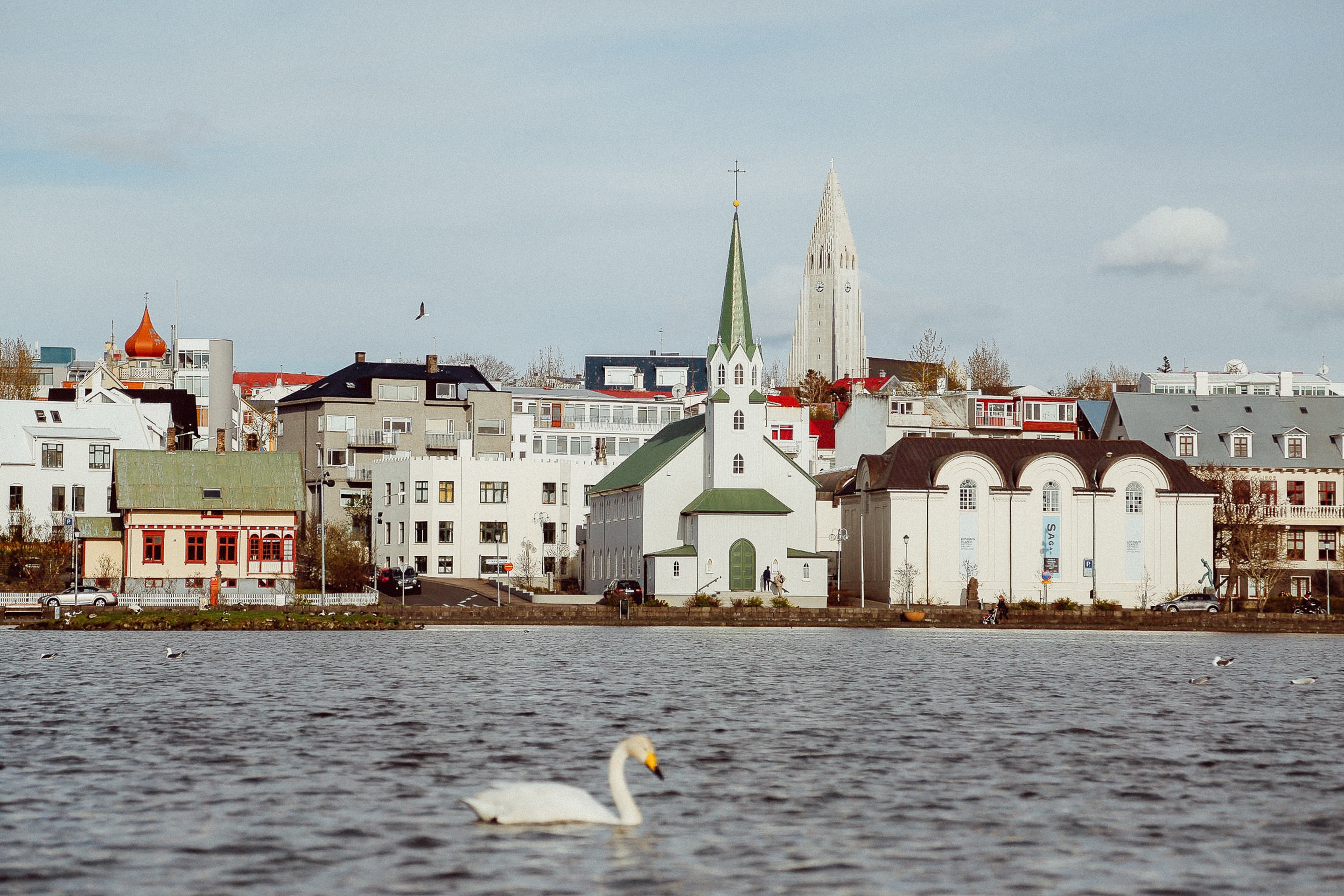
Sprawling Reykjavík, the nation's nerve center and government seat, is home to half the island's population. On a bay overlooked by proud Mt. Esja (pronounced eh-shyuh), with its ever-changing hues, Reykjavík presents a colorful sight, its concrete houses painted in light colors and topped by vibrant red, blue, and green roofs. In contrast to the almost treeless countryside, Reykjavík has many tall, native birches, rowans, and willows, as well as imported aspen, pines, and spruces.Reykjavík's name comes from the Icelandic words for smoke, reykur, and bay, vík. In AD 874, Norseman Ingólfur Arnarson saw Iceland rising out of the misty sea and came ashore at a bay eerily shrouded with plumes of steam from nearby hot springs. Today most of the houses in Reykjavík are heated by near-boiling water from the hot springs. Natural heating avoids air pollution; there's no smoke around. You may notice, however, that the hot water brings a slight sulfur smell to the bathroom.Prices are easily on a par with other major European cities. A practical option is to purchase a Reykjavík City Card at the Tourist Information Center or at the Reykjavík Youth Hostel. This card permits unlimited bus usage and admission to any of the city's seven pools, the Family Park and Zoo, and city museums. The cards are valid for one (ISK 3,300), two (ISK 4,400), or three days (ISK 4,900), and they pay for themselves after three or four uses a day. Even lacking the City Card, paying admission (ISK 500, or ISK 250 for seniors and people with disabilities) to one of the city art museums (Hafnarhús, Kjarvalsstaðir, or Ásmundarsafn) gets you free same-day admission to the other two.


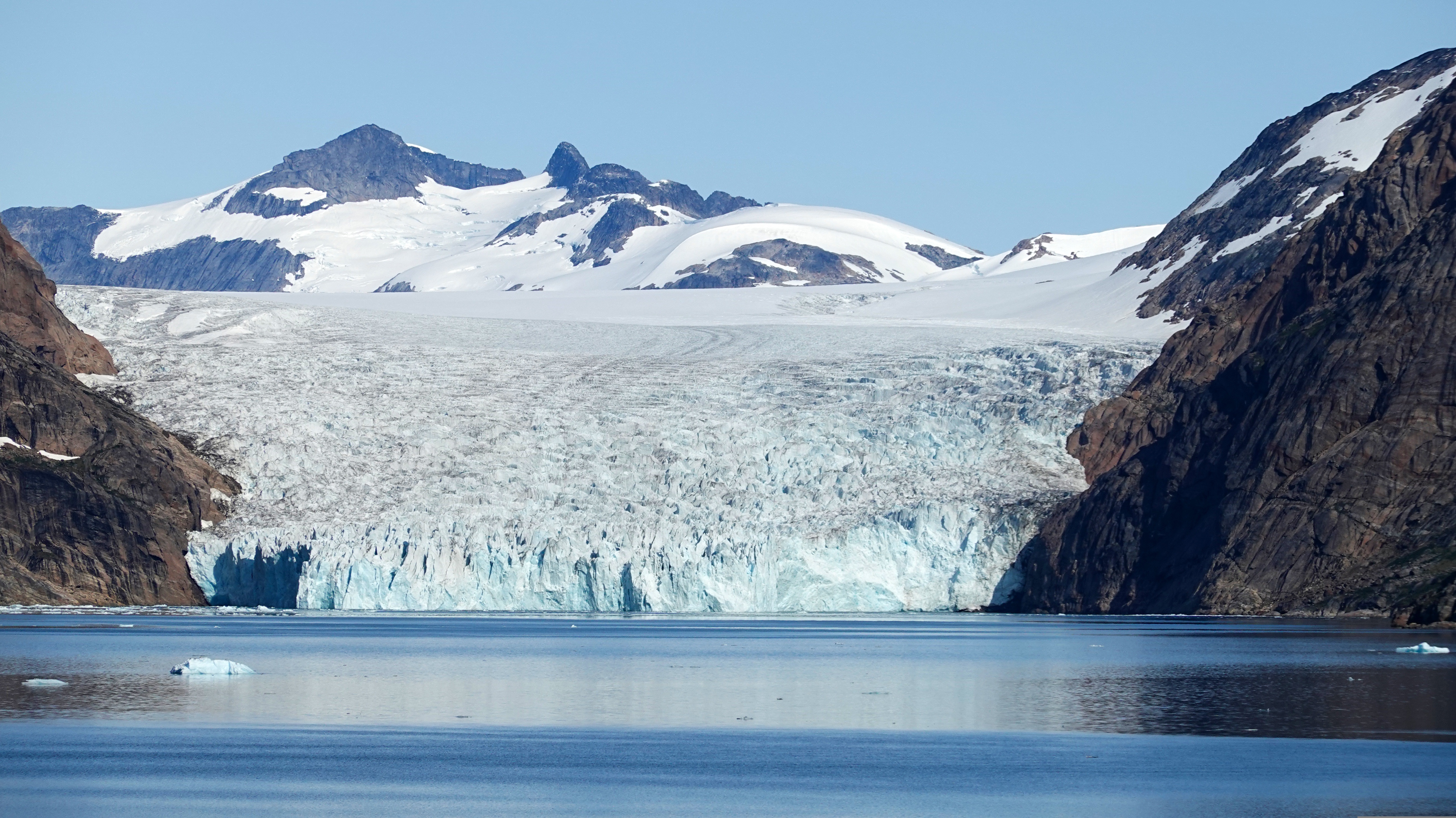
About Prince Christian Sound
The transit through the Sound is one of this voyage’s highlights. Connecting the Labrador Sea with the Irminger Seat, Prince Christian Sound or “Prins Christian Sund” in Danish is named after Prince (later King) Christian VII (1749-1808). 100 km (60 miles ), long and at times just 500 m (1500 ft) wide, this majestic and spectacular fiord throws you back into a Viking era – flanked by soaring snow-topped mountains, rock-strewn cliffs and rolling hills, it is as if time has stood still and one easily forgets that this is the 21st century. As you marvel at the sheer size of the mountains that surround you, with the Arctic waters lapping deceptively at the hull, revel in the silence enveloping you. Icebergs float serenely by, carrying with them the ages of time. Be sure to wear warm clothing as this is one spectacle that you do not want to miss.
About Qaqortoq (Julianehaab)
The largest town in southern Greenland, Qaqortoq has been inhabited since prehistoric times. Upon arrival in this charming southern Greenland enclave, it's easy to see why. Qaqortoq rises quite steeply over the fjord system around the city, offering breath-taking panoramic vistas of the surrounding mountains, deep, blue sea, Lake Tasersuag, icebergs in the bay, and pastoral backcountry. Although the earliest signs of ancient civilization in Qaqortoq date back 4,300 years, Qaqortoq is known to have been inhabited by Norse and Inuit settlers in the 10th and 12th centuries, and the present-day town was founded in 1774. In the years since, Qaqortoq has evolved into a seaport and trading hub for fish and shrimp processing, tanning, fur production, and ship maintenance and repair.

About Hvalsey
Northeast of Qaqortoq and at the end of a fjord, Hvalsey is one of the best examples of South Greenland’s many scattered ruins from the Norse period. Today the area is used for sheep-grazing, but until the 15th century the settlement at Hvalsey, and specifically Hvalsey’s church, played an important part. Christianity had spread its influence throughout Europe and eventually had reached remote Greenland, where it established itself in the country in 1000 AD. Hvalsey Church was built in the 14th century and is the best preserved of the churches in Greenland from that period. Apart from the church walls, historical ruins from the time of the Norse are just a few meters away.
About Paamiut (Fredrikshaab)

About Nuuk (Godthaab)
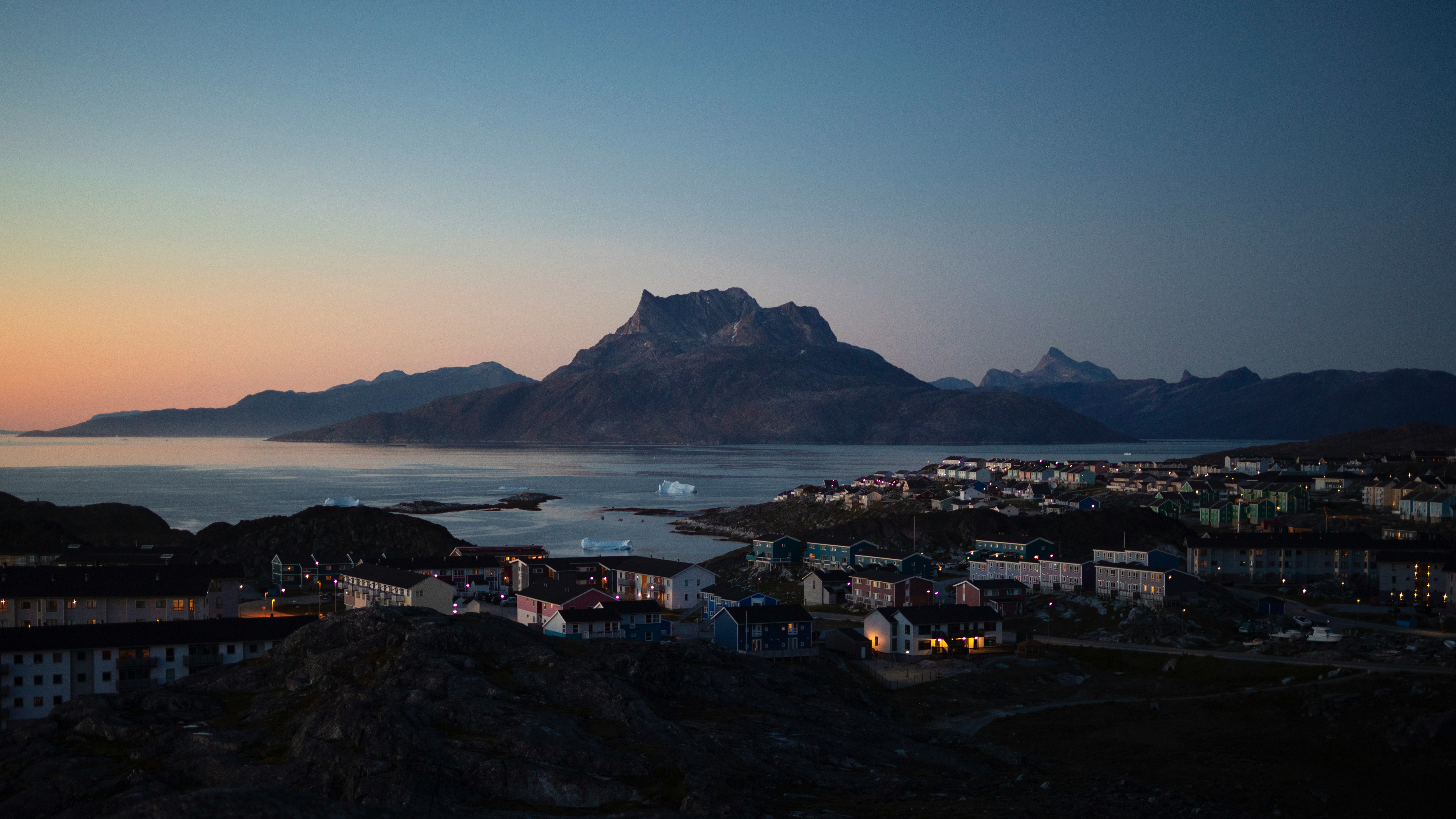
Nuuk, meaning “the cape”, was Greenland’s first town (1728). Started as a fort and later mission and trading post some 240 kilometers south of the Arctic Circle, it is the current capital. Almost 30% of Greenland’s population lives in the town. Not only does Nuuk have great natural beauty in its vicinity, but there are Inuit ruins, Hans Egede’s home, the parliament, and the Church of our Saviour as well. The Greenlandic National Museum has an outstanding collection of Greenlandic traditional dresses, as well as the famous Qilakitsoq mummies. The Katuaq Cultural Center’s building was inspired by the undulating Northern Lights and can house 10% of Nuuk’s inhabitants.

About Maniitsoq (Sukkertoppen)
About Sermiligaaq
About Iqaluit, Nunavut
Iqaluit is the capital of Canada’s newest territory, Nunavut, which is Inuktitut for “our land”. The community is located at the head of Frobisher Bay, an inlet of the North Atlantic extending into southeastern Baffin Island. The Bay is so long that it was first taken to be the possible entrance of a Northwest Passage. In Iqaluit, the Nunatta Sunakkutaangit Museum and the Nunavut Legislative Assembly Building both house incredible collections of Inuit artwork with interesting local prints for sale in the museum shop.
About Lady Franklin Island, Nunavut
Named in honour of Sir John Franklin’s widow, the lonely and uninhabited Lady Franklin Island lies off of Baffin Island’s Hall Peninsula at the entrance to Cumberland Sound. The island is named for the wife of Sir John Franklin, the Arctic explorer who died trying to discover the Northwest Passage. The geology of the island is striking with vertical cliffs of Archean rocks, likely to be some of the oldest stone in Canada. The waters around Lady Franklin Island offer an abundance seabirds, ducks, seals, and walrus. With a bit of luck it is possible to see Atlantic Puffins here and perhaps even a rare Sabine’s Gull.
About Monumental Island, Baffin Islands, Nunavut
Monumental Island in Davis Strait was named by Arctic explorer Charles Francis Hall as a tribute to the memory of Sir John Franklin who died in his quest to find the Northwest Passage. The island is offshore of Baffin Island in the Canadian Arctic Archipelago of the territory of Nunavut. Around the shoreline scores of Black Guillemots dive and fish for little Arctic cods and capelins. Successful birds fly off with a minnow grasped tightly in their beaks. On a far larger scale, it is possible to find groups of walruses with their impressive tusks along the shores of the island. However, the coup de grâce is to spot a polar bear’s white silhouette against the dark background of the bedrock on Monumental Island.
About Akpatok Island, Nunavut
Akpatok Island is the largest island in the middle of Ungava Bay, south of Baffin Island and north of Quebec. Its name is the local name for the Thick-billed Murre, which nests here in vast numbers. In fact, the entire island is designated a Canadian Important Bird Area. Other common wildlife are Polar bears, seals, and walrus. One of the most distinctive features of the island is the steep limestone cliffs ringing the shore. They rise 490 to 820 feet straight up from the sea to a flat plateau. Although is uninhabited today, remains of a Dorset settlement have been documents at the southern end of the island.
About Kimmirut, Nunavut
About Cape Dorset, Nunavut
Cape Dorset is a small Inuit hamlet located on Dorset Island, off the southern shore of Baffin Island. The traditional name for Cape Dorset is Kinngait (meaning "high mountain"), describing the ‘Cape’, which is actually a 800 foot mountain. This is a nature-lovers paradise with breath-taking landscapes and an amazing abundance of arctic wildlife, such as migratory caribou, seabirds, whales, seals and walruses. Ancient native Thule (Dorset Culture) peoples lived in this area for three thousand years, and it is here where the first archaeological remains were found. Captain Luke Foxe, during his attempt to find the Northwest Passage in 1631, was the first European to land here. He named the Cape in honour of his sponsor Edward Sackville, the Earl of Dorset. In 1913, the Hudson's Bay Company started a trading post, exchanging furs and skins for supplies like tobacco, ammunition, flour, gas, tea and sugar. In 1949, the market for white fox collapsed but the art industry boomed. Since the 1950s, Cape Dorset, the "Capital of Inuit Art", has become an economic mainstay of the community, with more than 20% of it residents employed in the arts.
About Coats Island, Nunavut
About Churchill, Manitoba
About Churchill, Manitoba


Where You'll Go


