Edinburgh to Reykjavik
Edinburgh to Reykjavik
Cruise overview
WHY BOOK WITH US?
- ✔ The Deluxe Cruises’ team has extensive experience in ultra-luxury cruising.
- ✔ Call now to speak to our helpful and experienced Cruise Concierge team.
- ✔ Enjoy our Unique Deluxe Cruises Bonus for substantial savings.
- ✔ Our team will tailor your holiday to your exacting requirements.
- ✔ As agents, we work under the protection of each cruise lines ABTA / ATOL licences
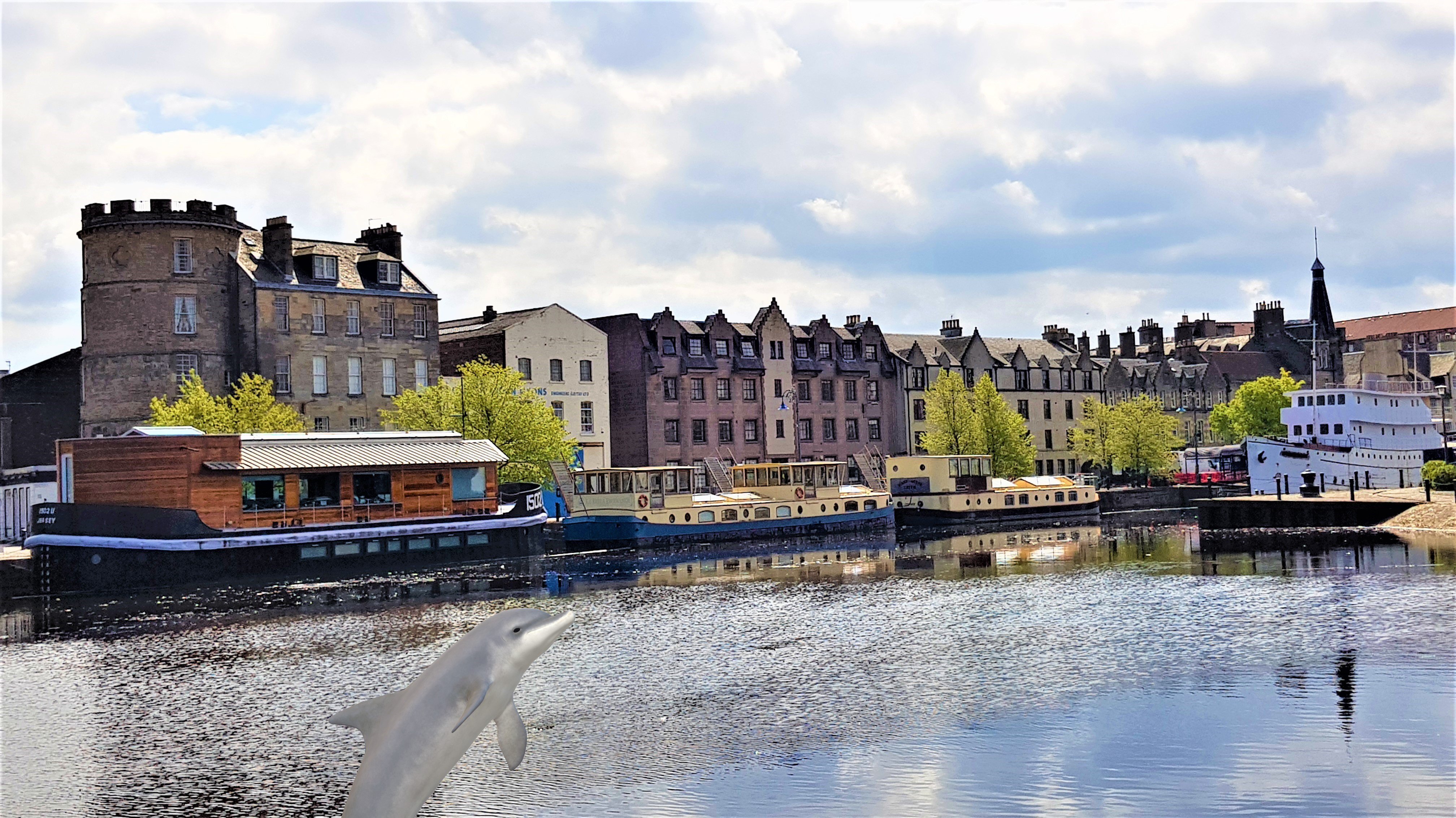
About Leith
About Isle of May
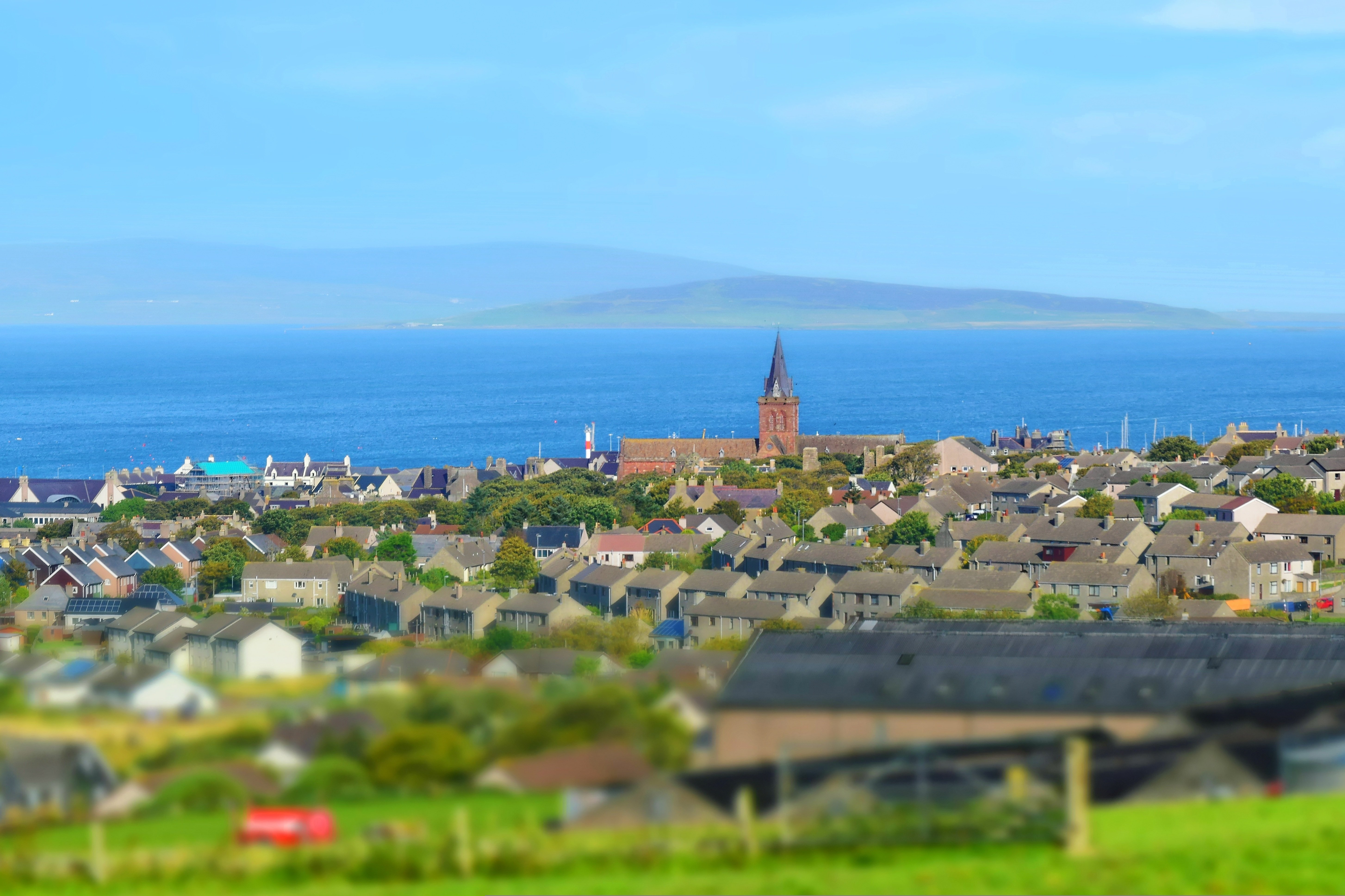
About Kirkwall, Orkney Islands
In bustling Kirkwall, the main town on Orkney, there's plenty to see in the narrow, winding streets extending from the harbor. The cathedral and some museums are highlights.

About North Haven, Fair Isle
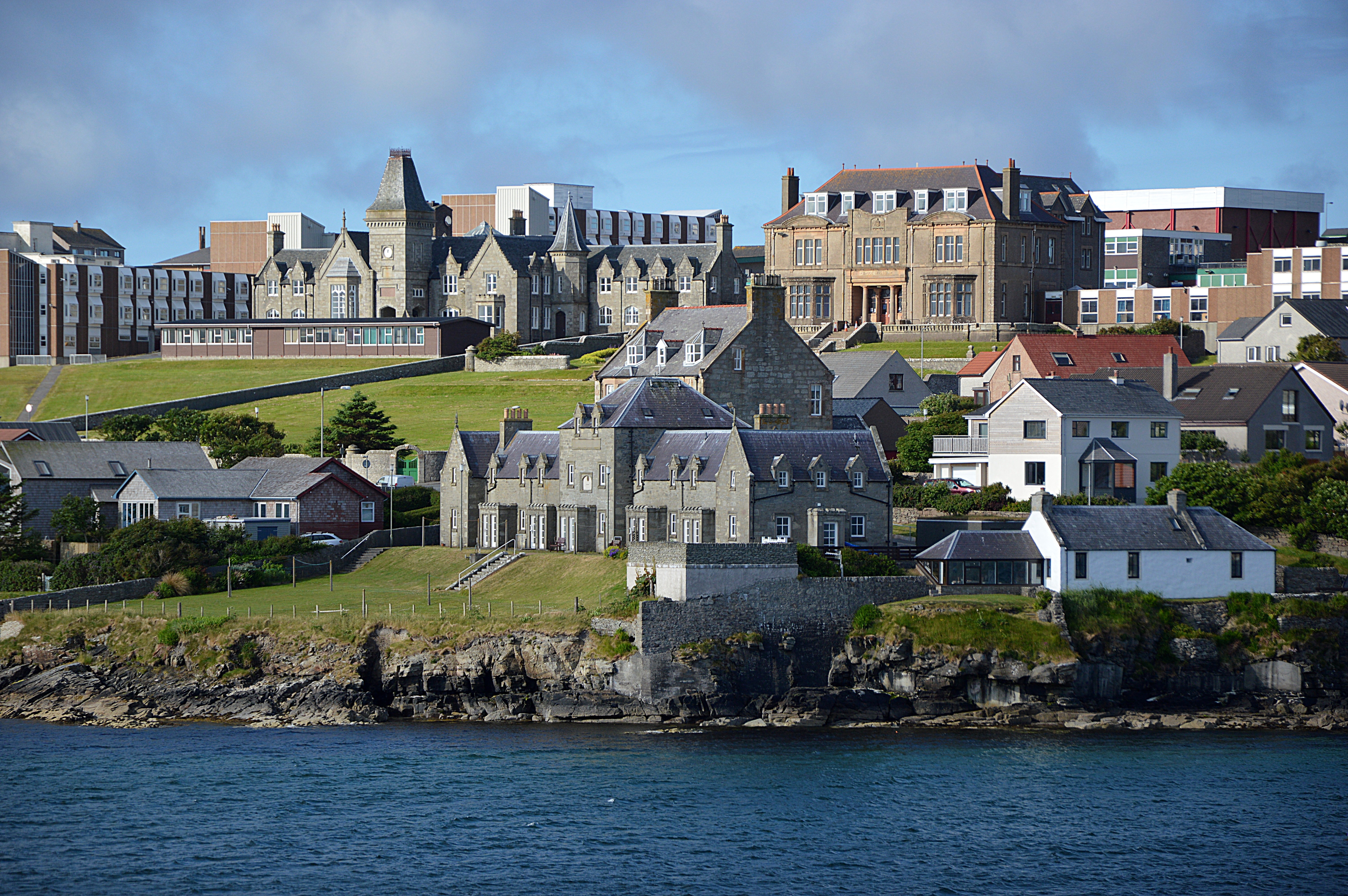
About Lerwick, Shetland Islands
Founded by Dutch fishermen in the 17th century, Lerwick today is a busy town and administrative center. Handsome stone buildings—known as lodberries—line the harbor; they provided loading bays for goods, some of them illegal. The town's twisting flagstone lanes and harbor once heaved with activity, and Lerwick is still an active port today. This is also where most visitors to Shetland dock, spilling out of cruise ships, allowing passengers to walk around the town.

About Isle of Noss
Exploring the sandstone cliff faces of the Isle of Noss will reveal ledges loaded with gannets, puffins, guillemots, shags, kittiwakes, Razorbills, fulmars and Great Skuas. The island was recognized as a National Nature Reserve in 1955, and has one of Europe’s largest and most diverse seabird colonies. Sheep have grazed the inland hillsides of Noss since the late 1800s and early 1900s when around twenty people lived on the island to manage the sheep farm. Along with the sheep, shaggy Shetland ponies graze the windblown slopes of Noss.
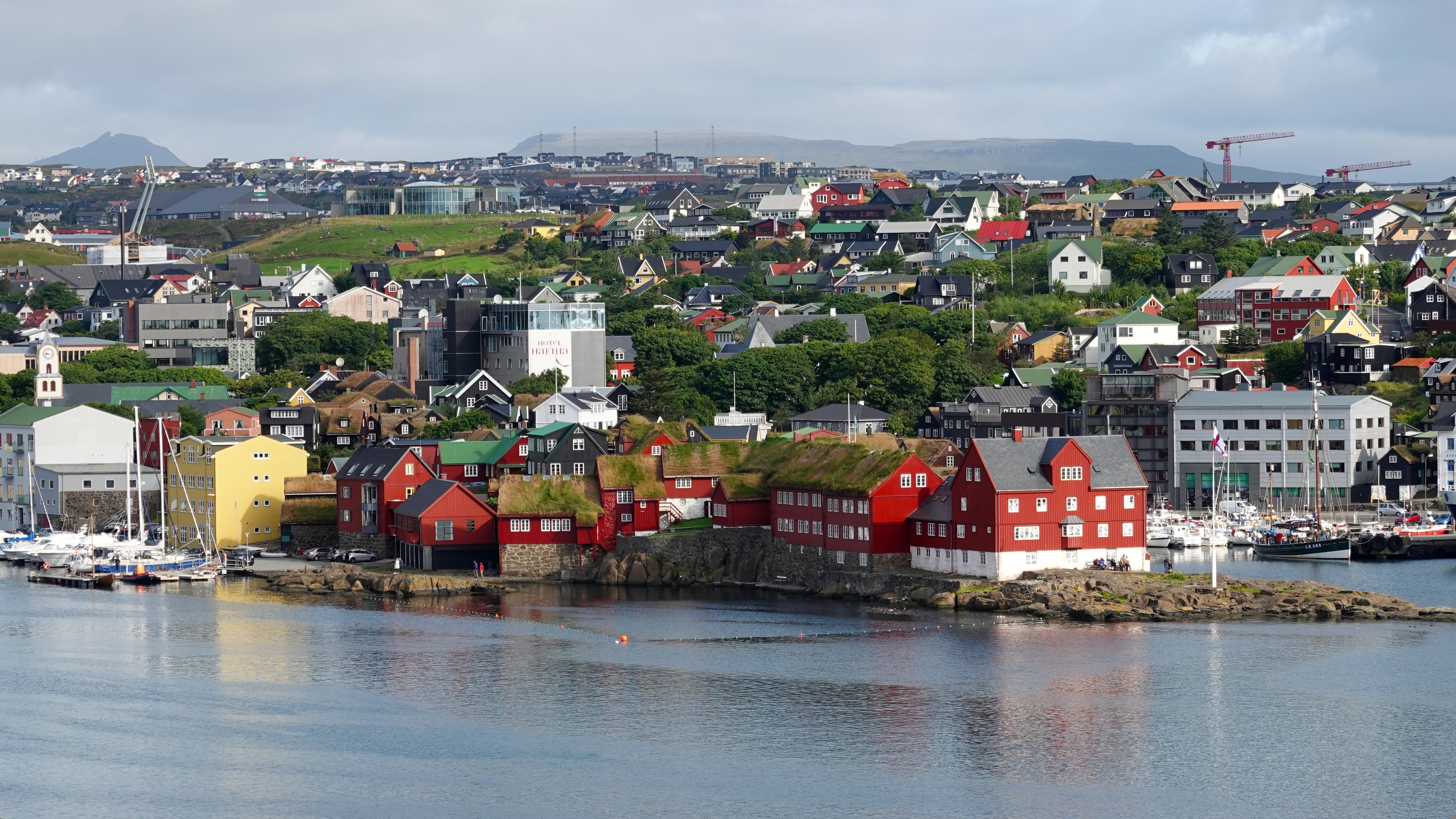
About Thorshavn
More than 600 miles (nearly 1,000 kilometres) from Denmark’s west coast lie the Faroes, a triangle of eighteen windswept islands, seventeen of which are inhabited. Only 48,500 people plus some 70,000 sheep roam these remote lands. Much of the islands’ heritage reflects a medieval past, beginning with the arrival of farmers from western Norway who settled here in the 9th century. Evidence of this Scandinavian heritage is preserved through centuries of isolation; ancient structures can still be seen in villages clustered around old churches. Sheer cliffs and waterfalls carve Streymoy, the largest of the islands, where Torshavn is one of the world’s smallest capitals with about 12,400 inhabitants, plus another 5,000 living in the suburbs of Argir and Hoyvik. Visitors find interesting museums, churches, monuments and all the amenities of a modern town and thriving harbour here. The world’s oldest, still active parliament was founded in the Viking age. Today, it houses the main offices of the local government. Many of the attractions are found outside of Torshavn in the rugged beauty of Streymoy. There are fields with grazing ponies and sheep, tiny hamlets where residents live in half-timbered houses topped by green grass roofs, and dramatic rock formations. Birds by the thousands populate the craggy seaside cliffs, which make an ideal stopover for migratory gannets, guillemots and puffins. The Faroes' climate is generally wet and windy. Because of the Gulf Stream, the temperature is a good deal more moderate than the latitude might imply; it also helps to keep Faroe harbours ice-free year-round.
About Vestmanna
The Vestmanna bird cliffs are near vertical, volcanic cliffs that rise steeply out of the ocean to a height of over 600 meters. They are impressively covered with innumerable bird nesting sites as well rare and hardy vegetation. Literally tens of thousands of seabirds can be seen soaring along the cliffs, sitting on nests as well as swimming across the water. Species include numerous kittiwakes, Common Guillemots, Black Guillemots and the endearing Atlantic Puffin. In addition, several waterfalls cascade down in graceful mists from hundreds of meters in the air and explorations reveal a series of sea caves ranging from modest in size to enormous.
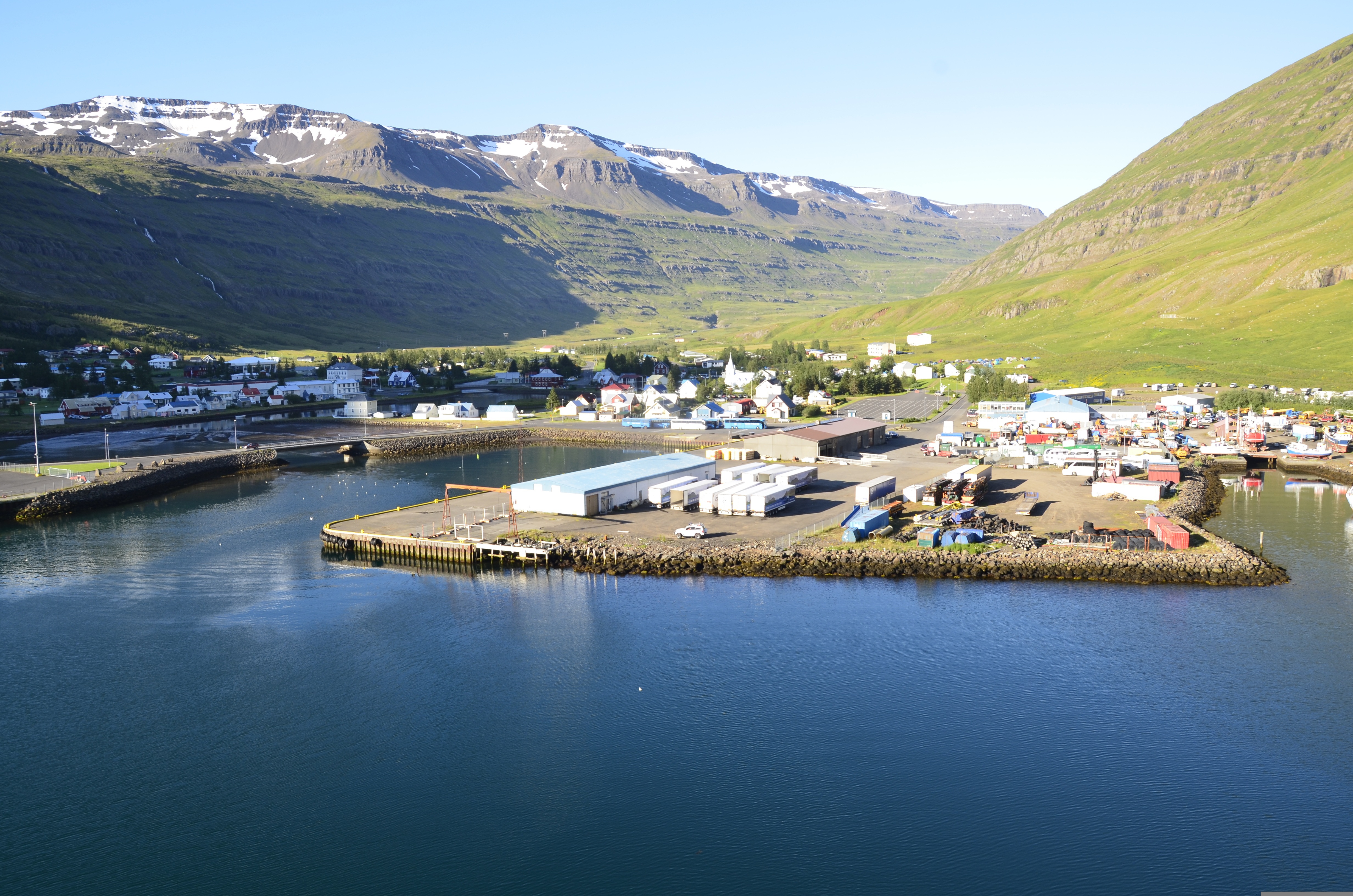
About Seydisfjørdur
Seyðisfjörður, a beautiful 19th-century Norwegian village on the east coast of Iceland, is regarded by many as one of Iceland's most picturesque towns, not only due to its impressive environment, but also because nowhere in Iceland has a community of old wooden buildings been preserved so well as here. Poet Matthías Johannessen called Seyðisfjörður a 'pearl enclosed in a shell'. The community owes its origins to foreign merchants, mainly Danes, who started trading in the fjord in the mid-19th century. But the crucial factor in the evolution of the village was the establishment of the Icelandic herring fishery by Norwegians in 1870-1900. The Norwegians built up a number of herring-fishing facilities, and in a matter of years the little community grew into a boom town. Today, about 800 people live in Seyðisfjörður. The local economy has long been based on the fisheries, while light industry also flourishes. Tourism is playing a growing role, as the picturesque town in its spectacular surroundings attracts more and more visitors. The car/passenger ferry Norrøna, which plies between continental Europe and Iceland every summer, docks at Seyðisfjörður every Thursday. Seyðisfjörður has been a cosmopolitan community from its foundation, and the ferry service has contributed to ensuring that it remains so.
About Bakkagerði
About Hólmavík
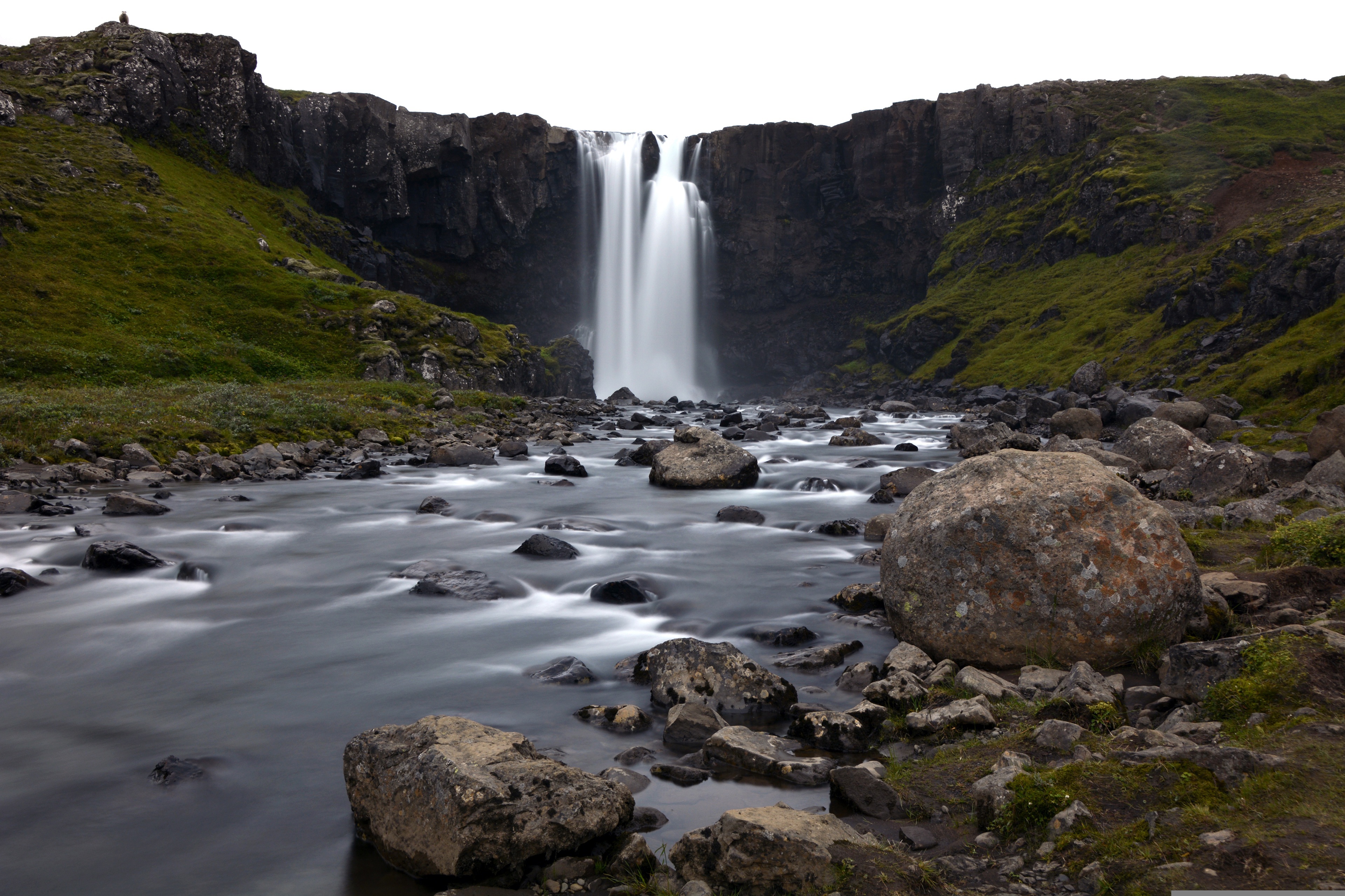
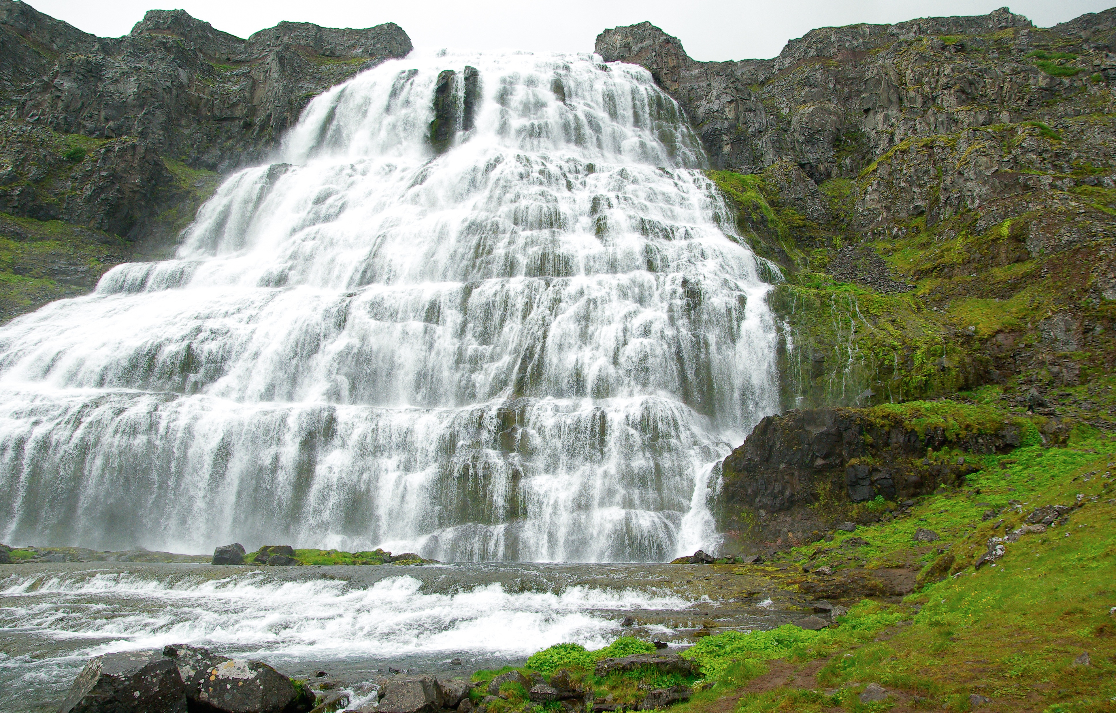
About Dynjandi Waterfalls
Iceland is well-known for its spectacular waterfalls. The iconic Dynjandi waterfall, located in the Westfjords region, is regarded as one of Iceland’s most impressive and majestic waterfalls. At the top, the cascading water is roughly 100 feet wide and tumbles down about 330 feet into the fjord. Its name Dynjandi means, “the thundering one” and its vast size, enormous sound, and sheer force is overwhelming. It has also been nicknamed, ‘The Bridal Veil’ because of the way the water sprays and spreads over the rocks.
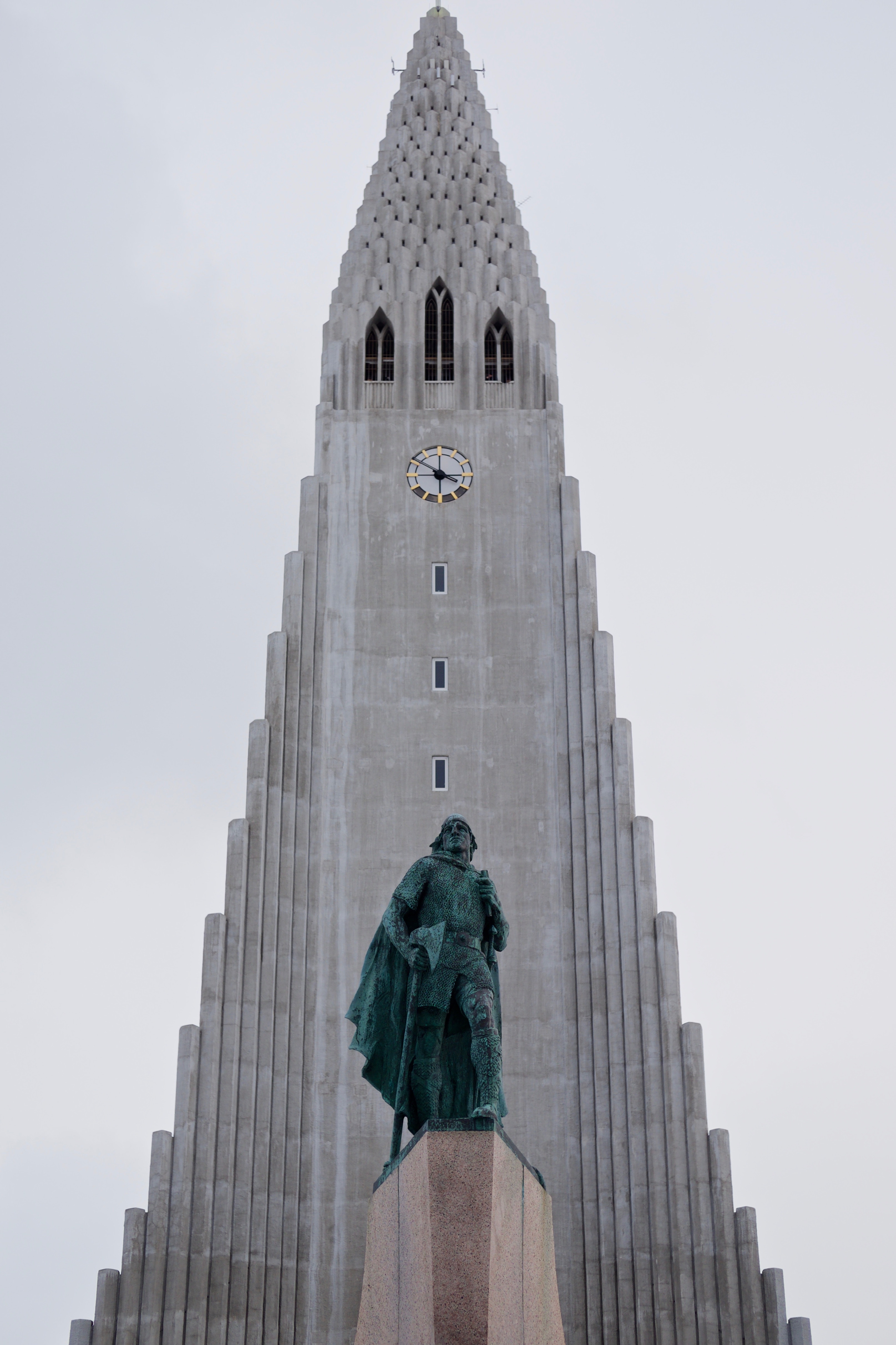
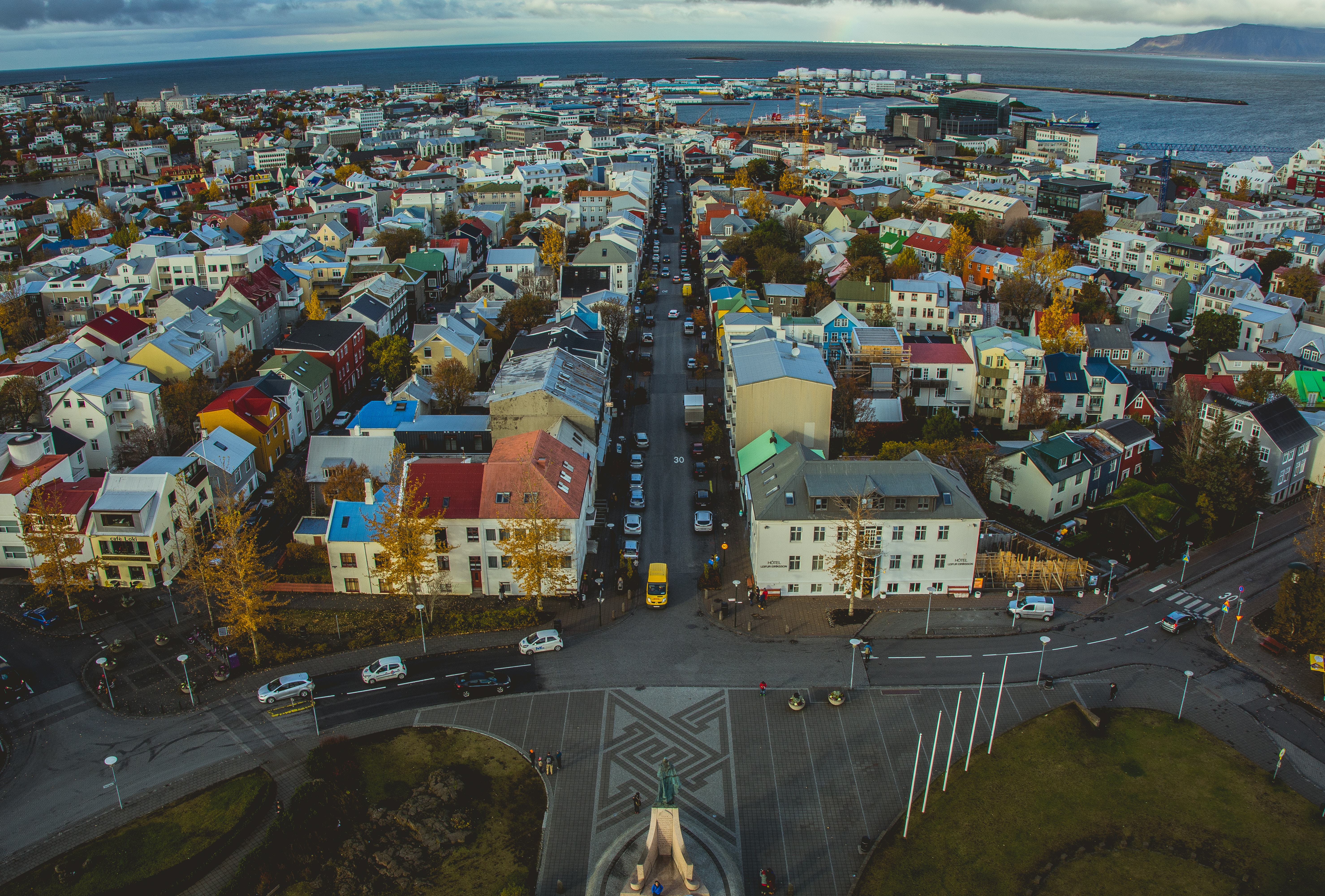
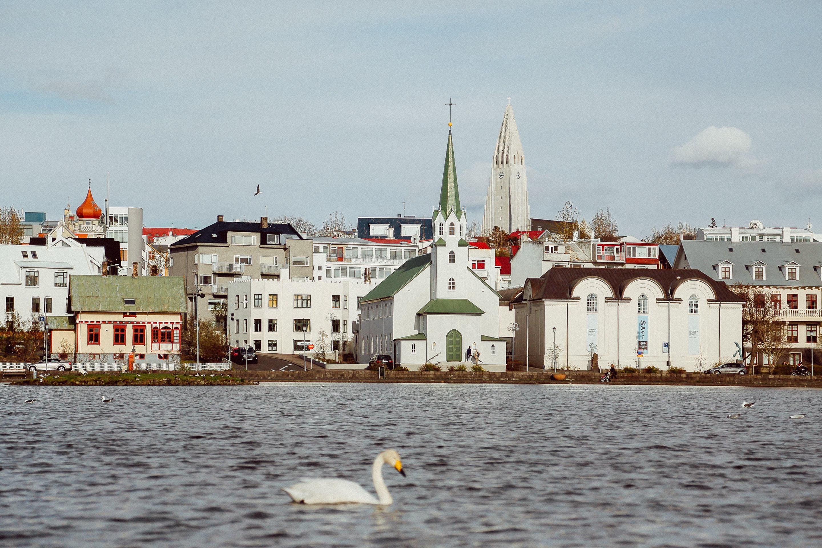
About Reykjavík
Sprawling Reykjavík, the nation's nerve center and government seat, is home to half the island's population. On a bay overlooked by proud Mt. Esja (pronounced eh-shyuh), with its ever-changing hues, Reykjavík presents a colorful sight, its concrete houses painted in light colors and topped by vibrant red, blue, and green roofs. In contrast to the almost treeless countryside, Reykjavík has many tall, native birches, rowans, and willows, as well as imported aspen, pines, and spruces.Reykjavík's name comes from the Icelandic words for smoke, reykur, and bay, vík. In AD 874, Norseman Ingólfur Arnarson saw Iceland rising out of the misty sea and came ashore at a bay eerily shrouded with plumes of steam from nearby hot springs. Today most of the houses in Reykjavík are heated by near-boiling water from the hot springs. Natural heating avoids air pollution; there's no smoke around. You may notice, however, that the hot water brings a slight sulfur smell to the bathroom.Prices are easily on a par with other major European cities. A practical option is to purchase a Reykjavík City Card at the Tourist Information Center or at the Reykjavík Youth Hostel. This card permits unlimited bus usage and admission to any of the city's seven pools, the Family Park and Zoo, and city museums. The cards are valid for one (ISK 3,300), two (ISK 4,400), or three days (ISK 4,900), and they pay for themselves after three or four uses a day. Even lacking the City Card, paying admission (ISK 500, or ISK 250 for seniors and people with disabilities) to one of the city art museums (Hafnarhús, Kjarvalsstaðir, or Ásmundarsafn) gets you free same-day admission to the other two.
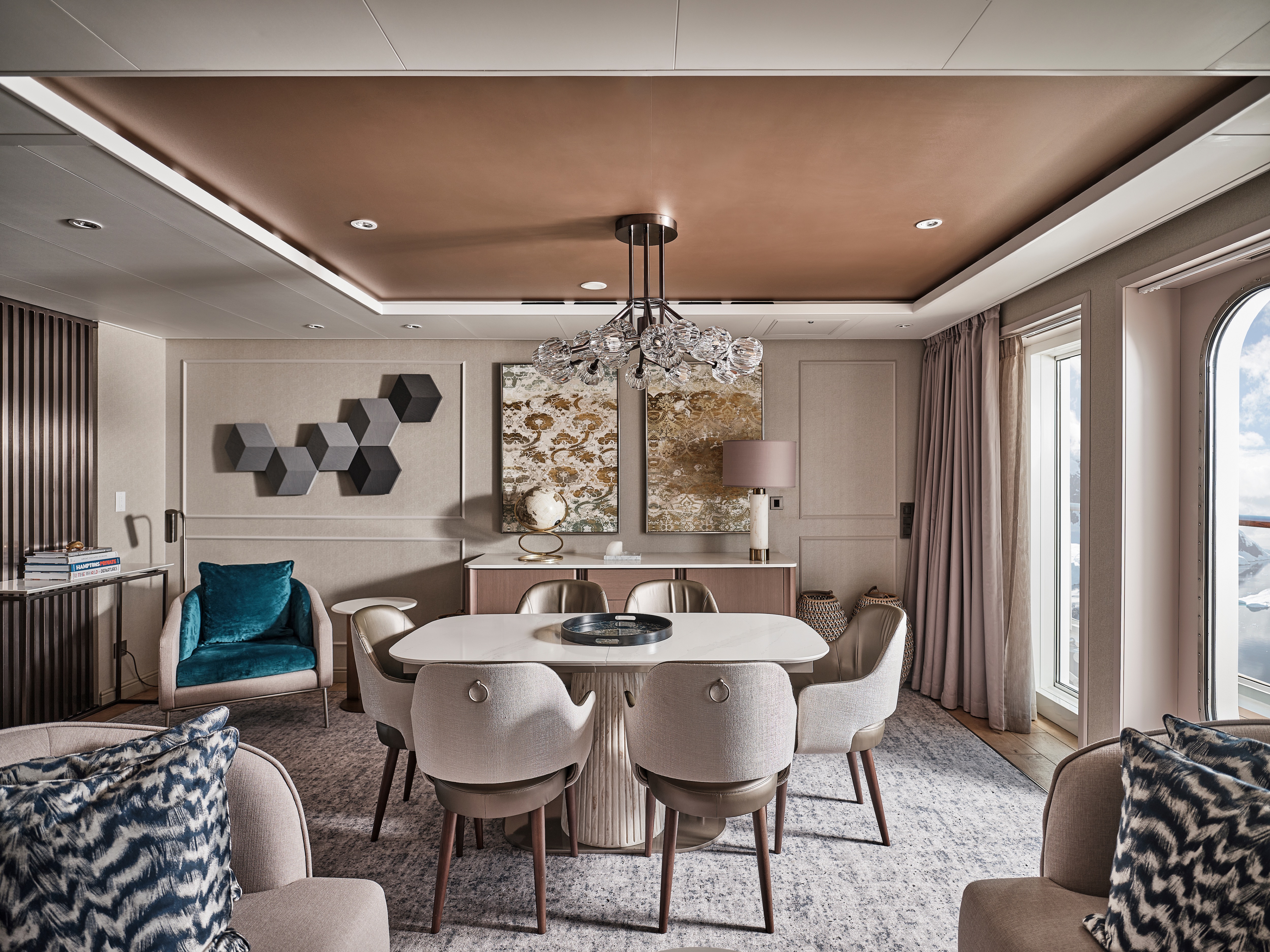
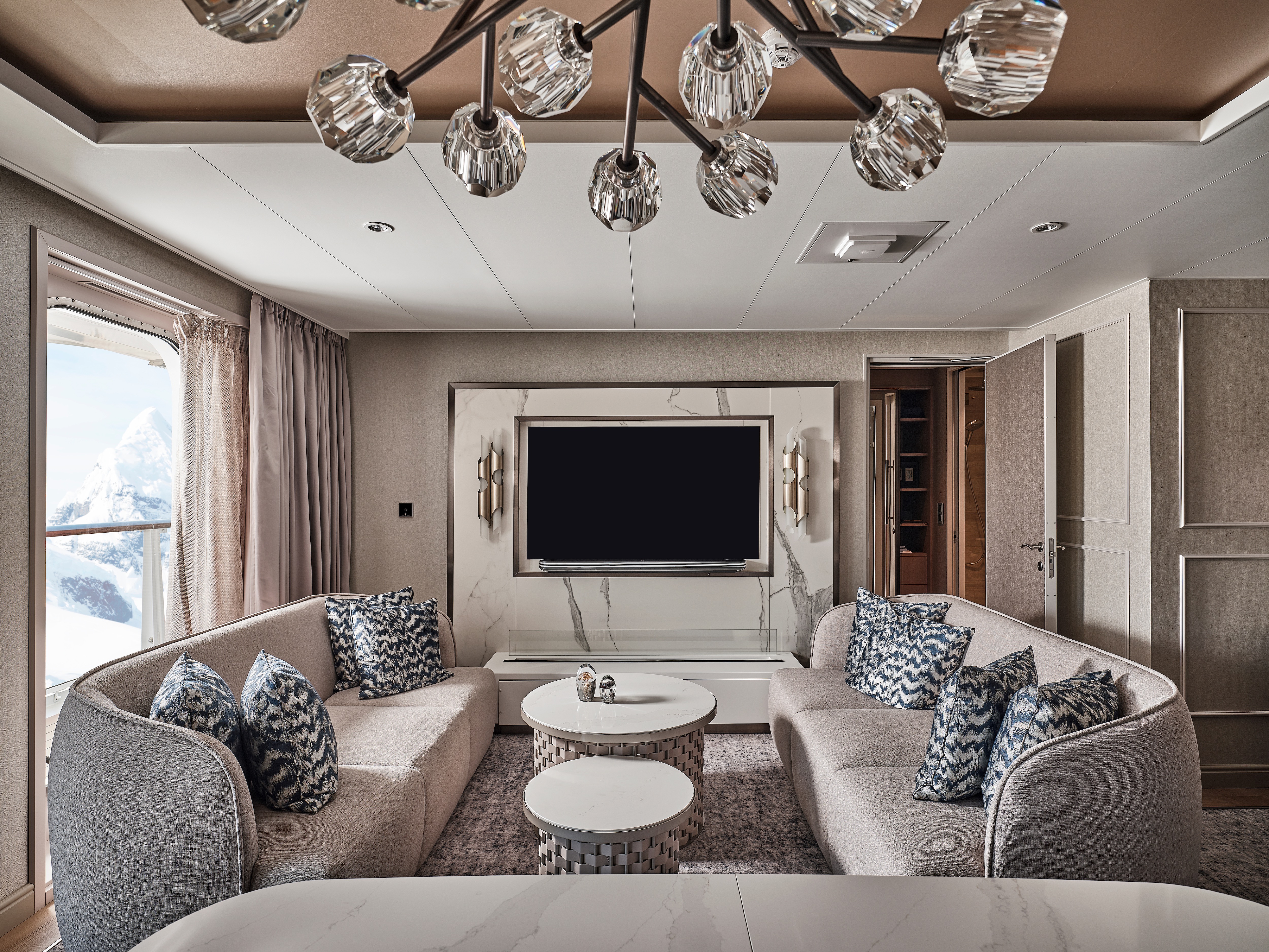
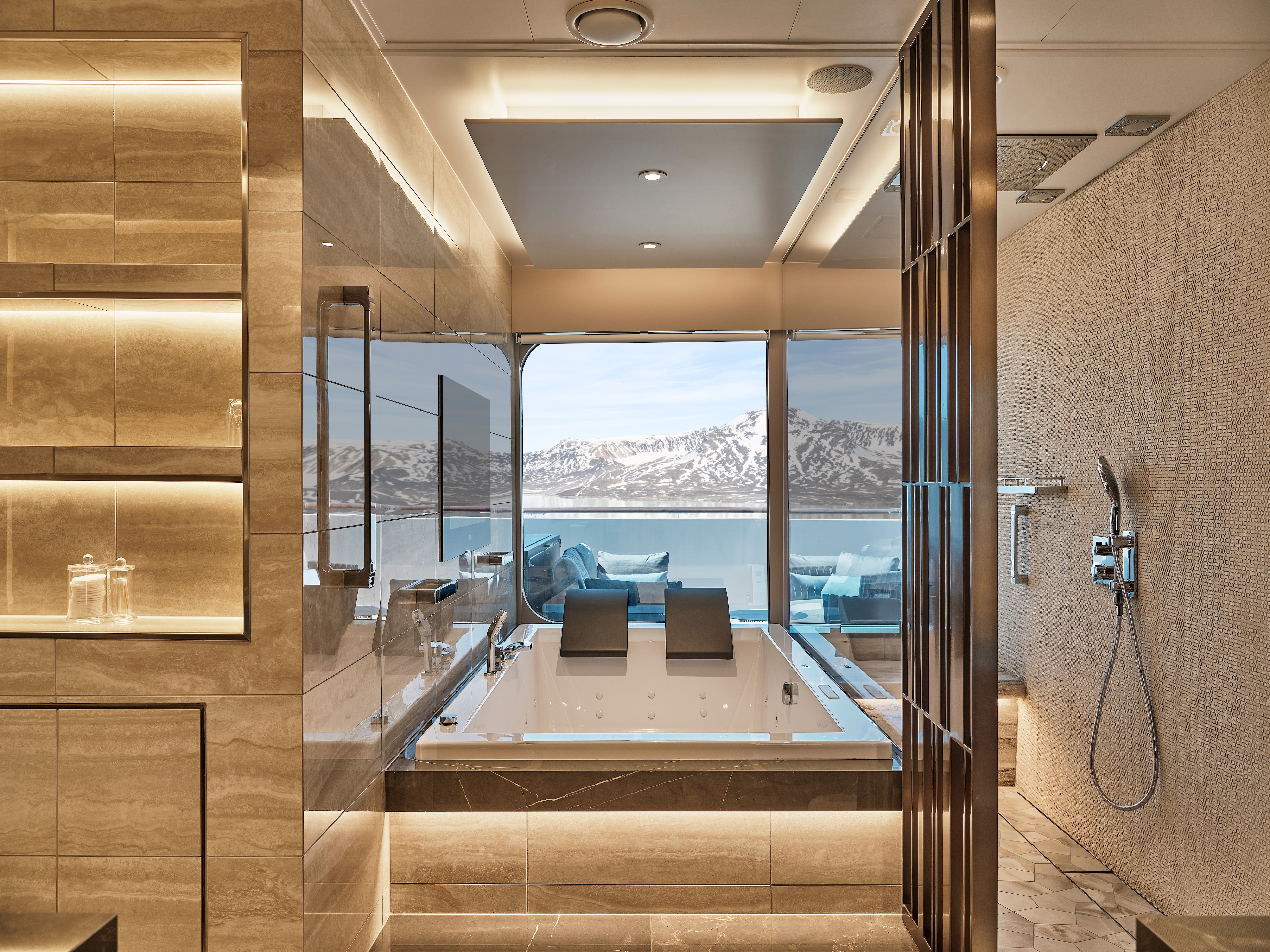
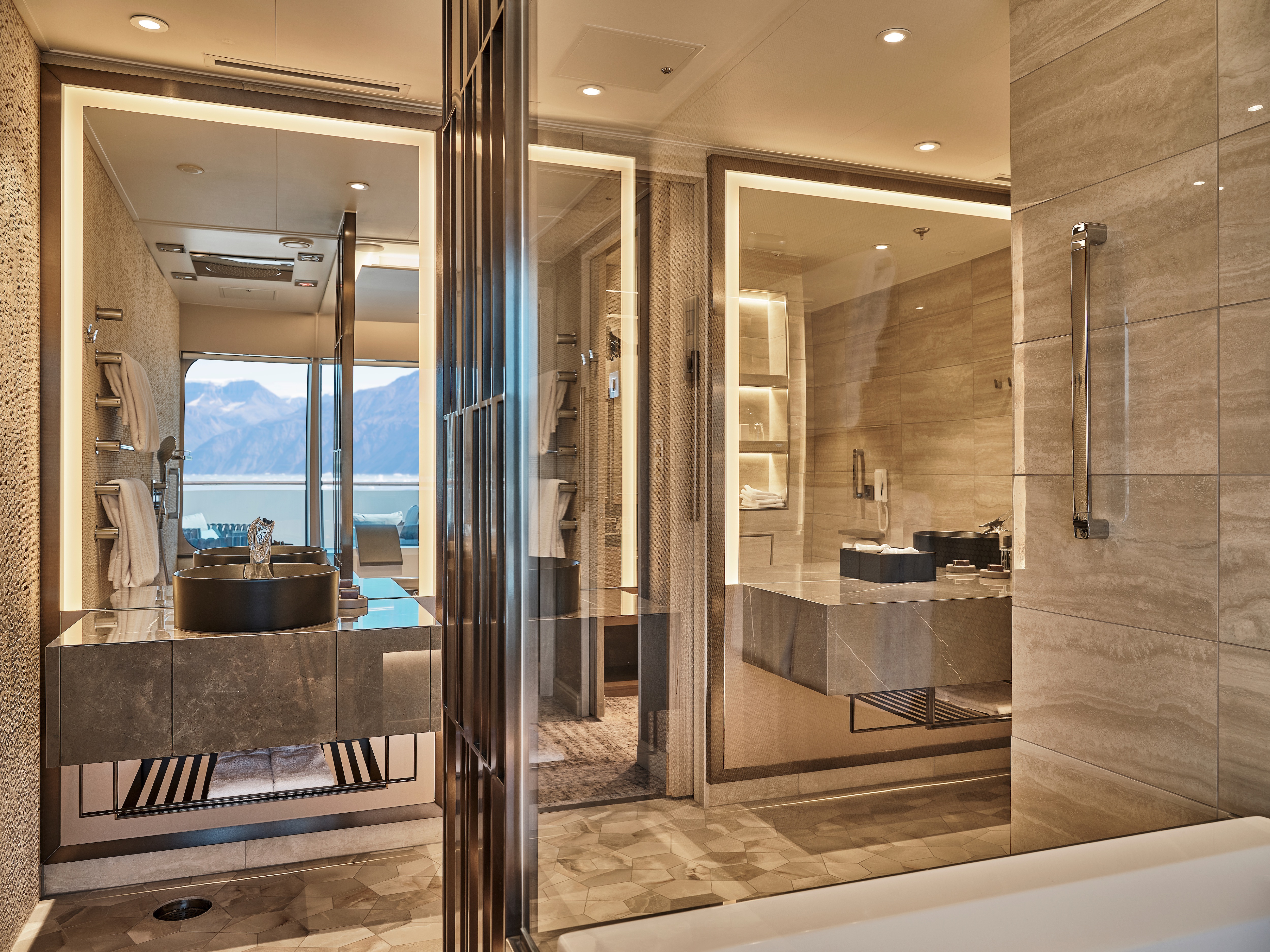
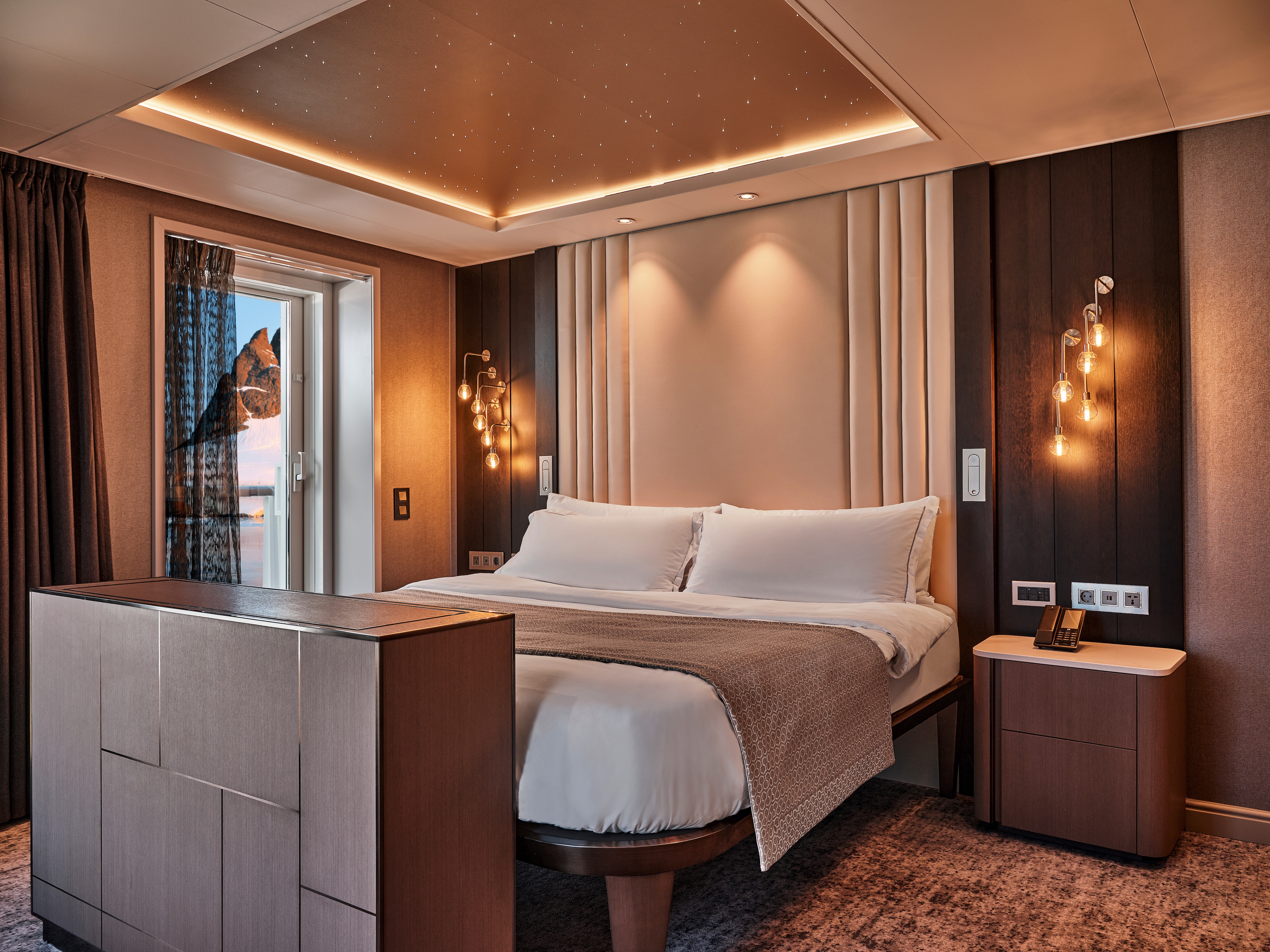
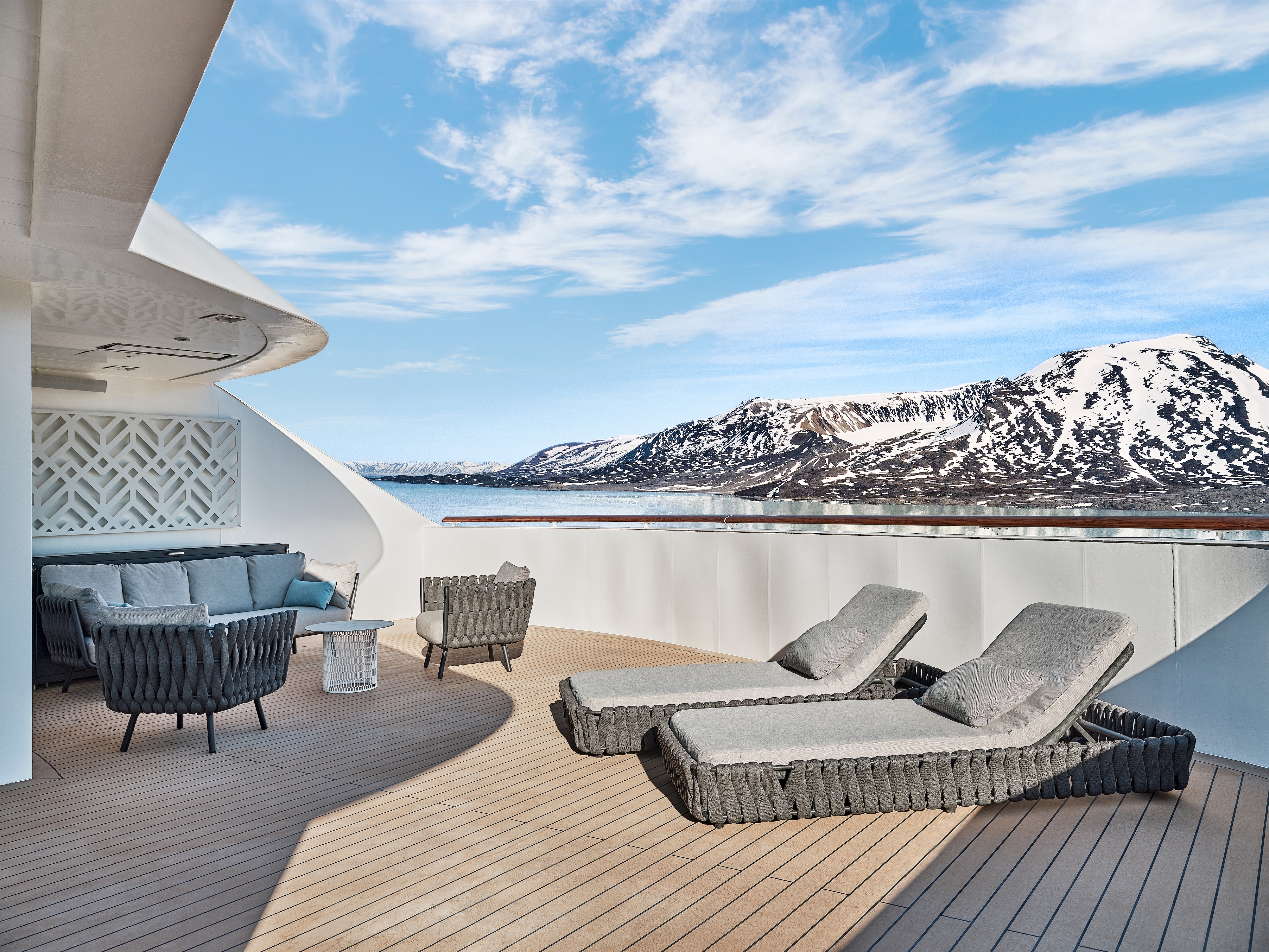
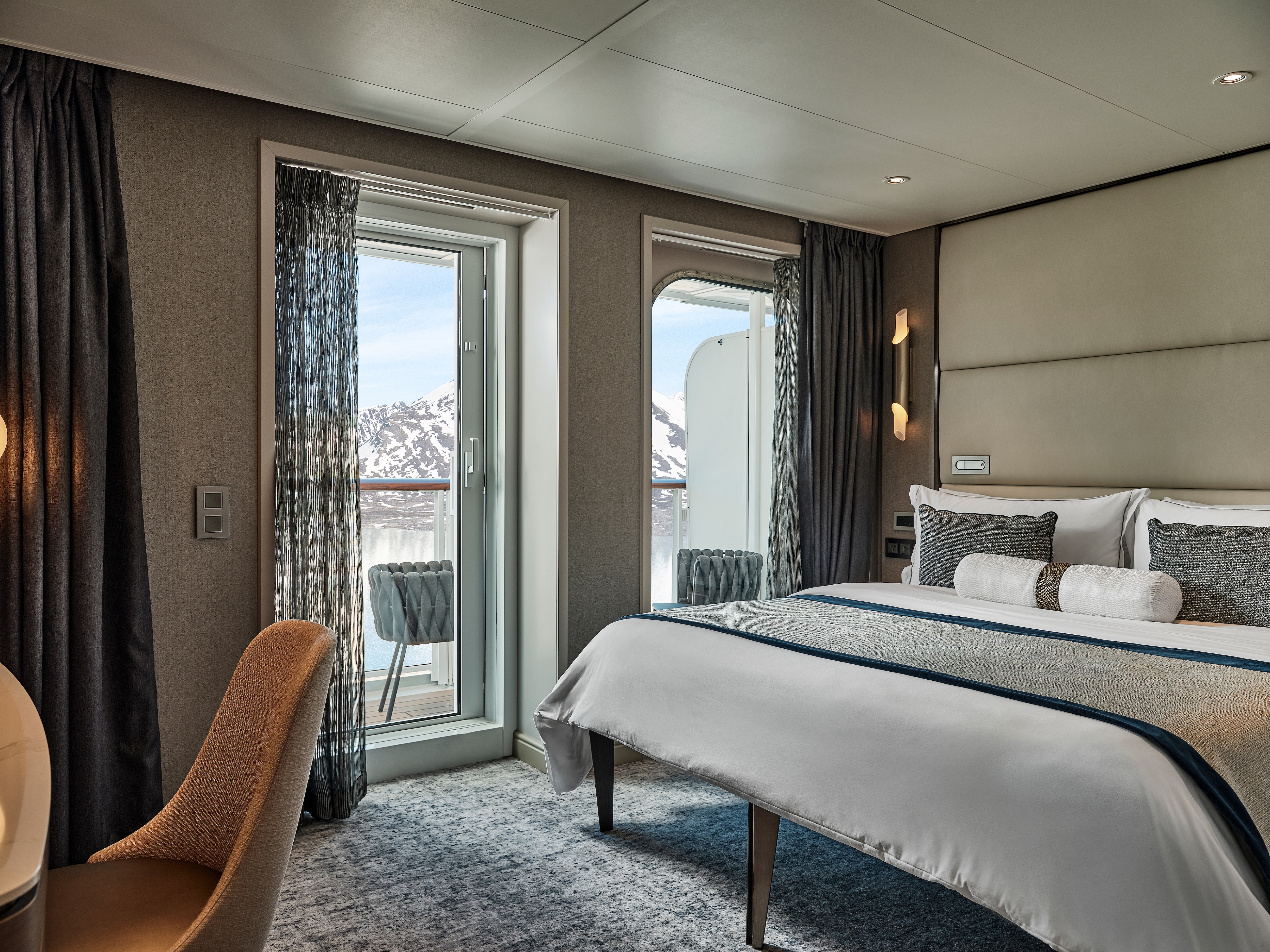
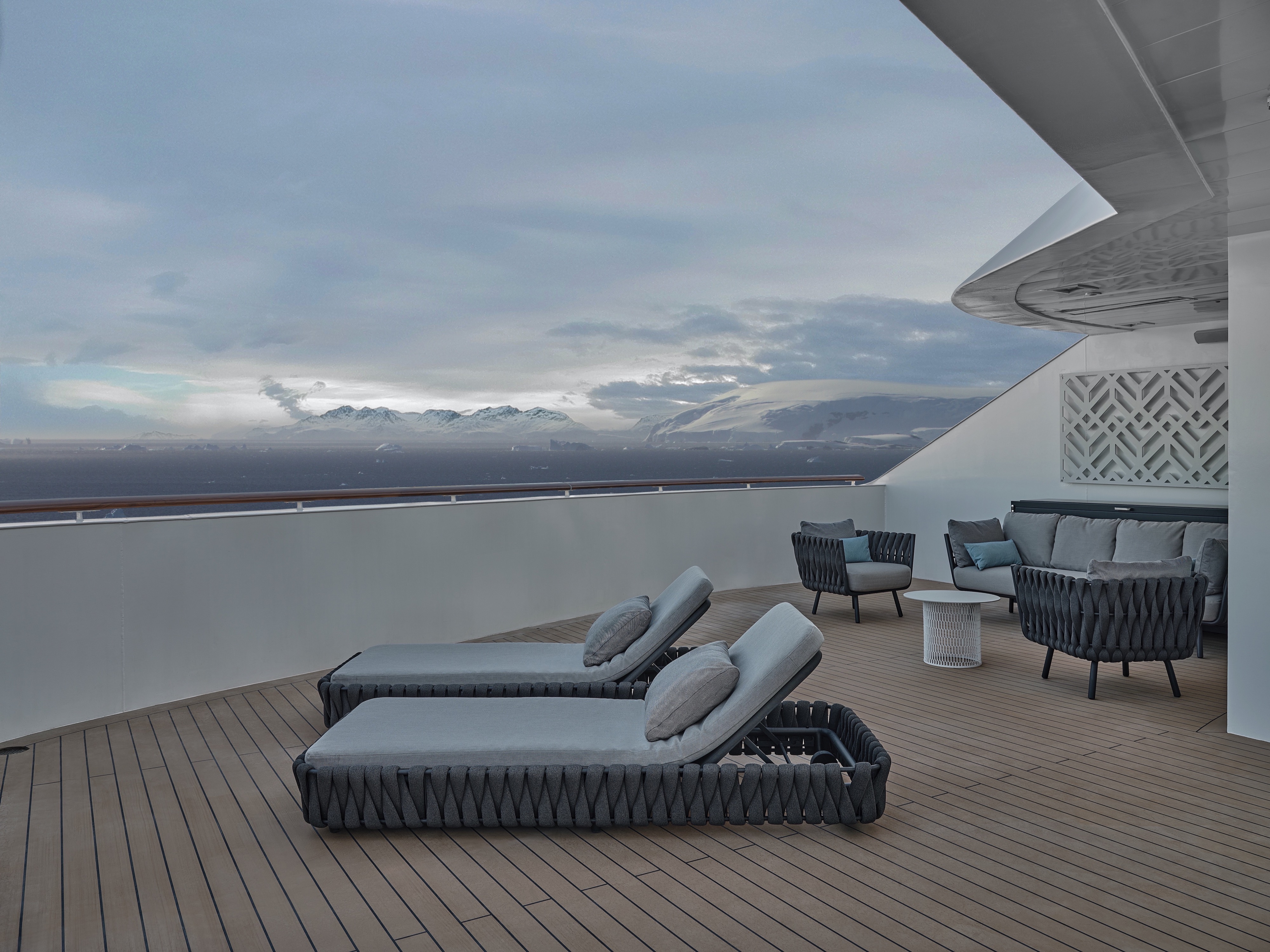
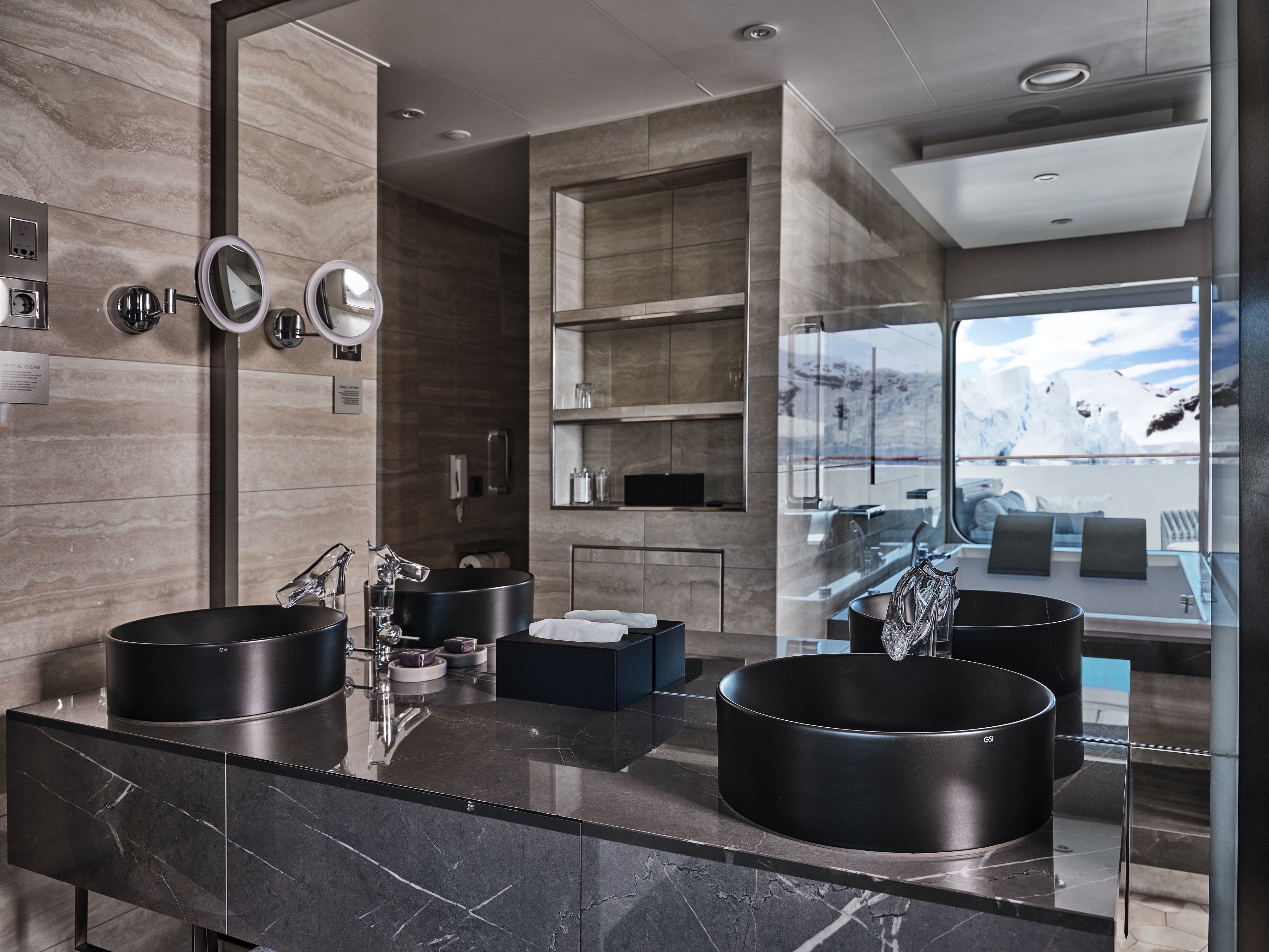
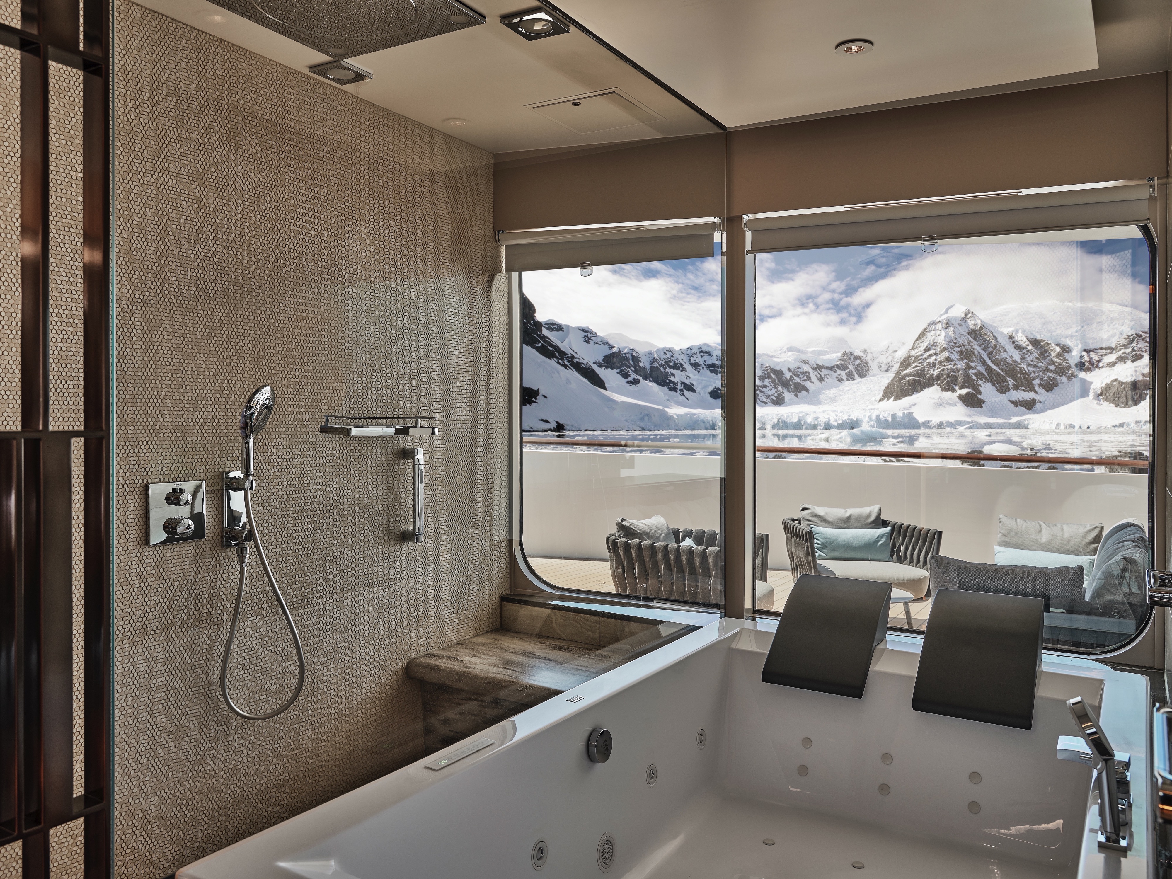
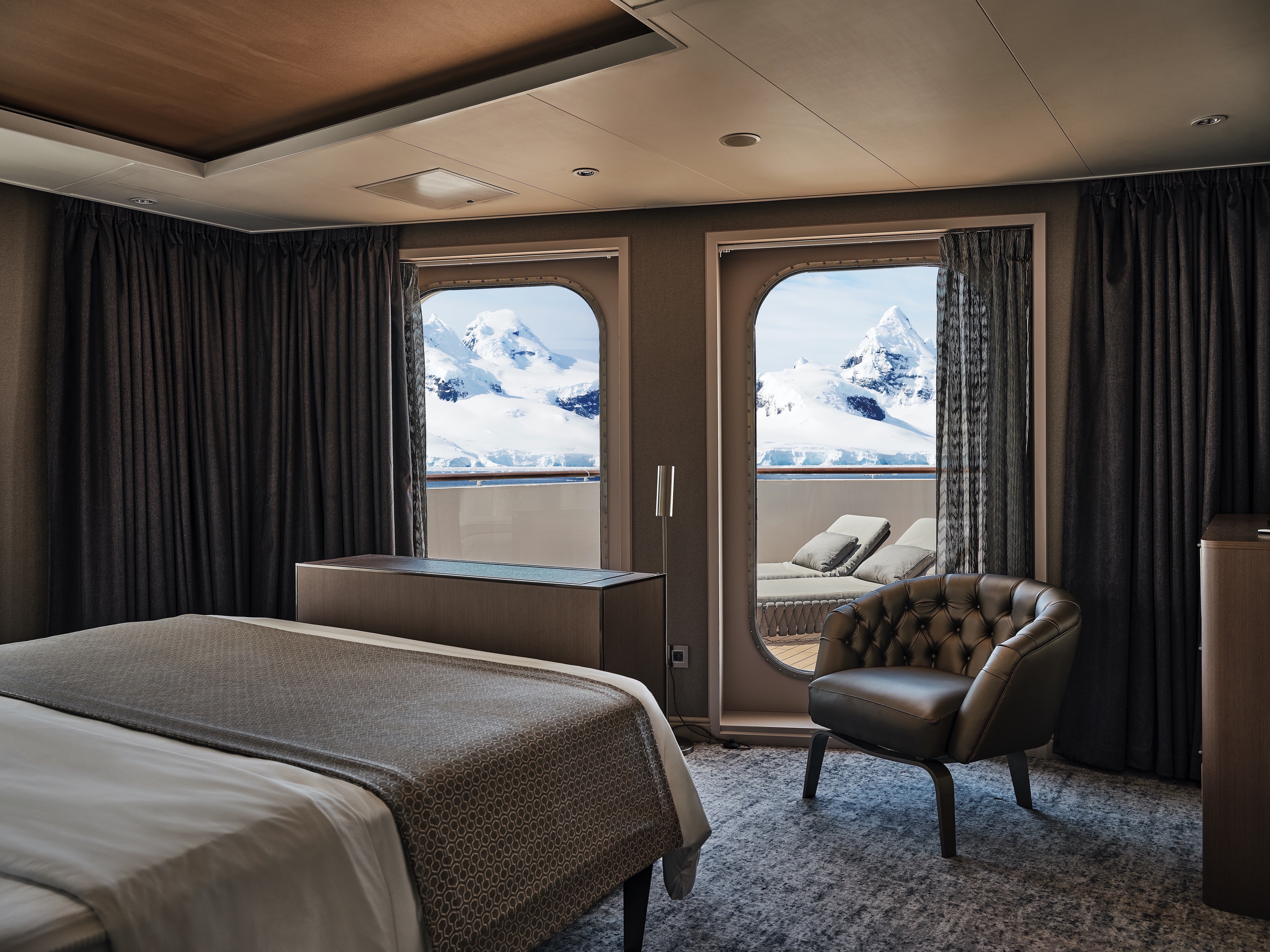
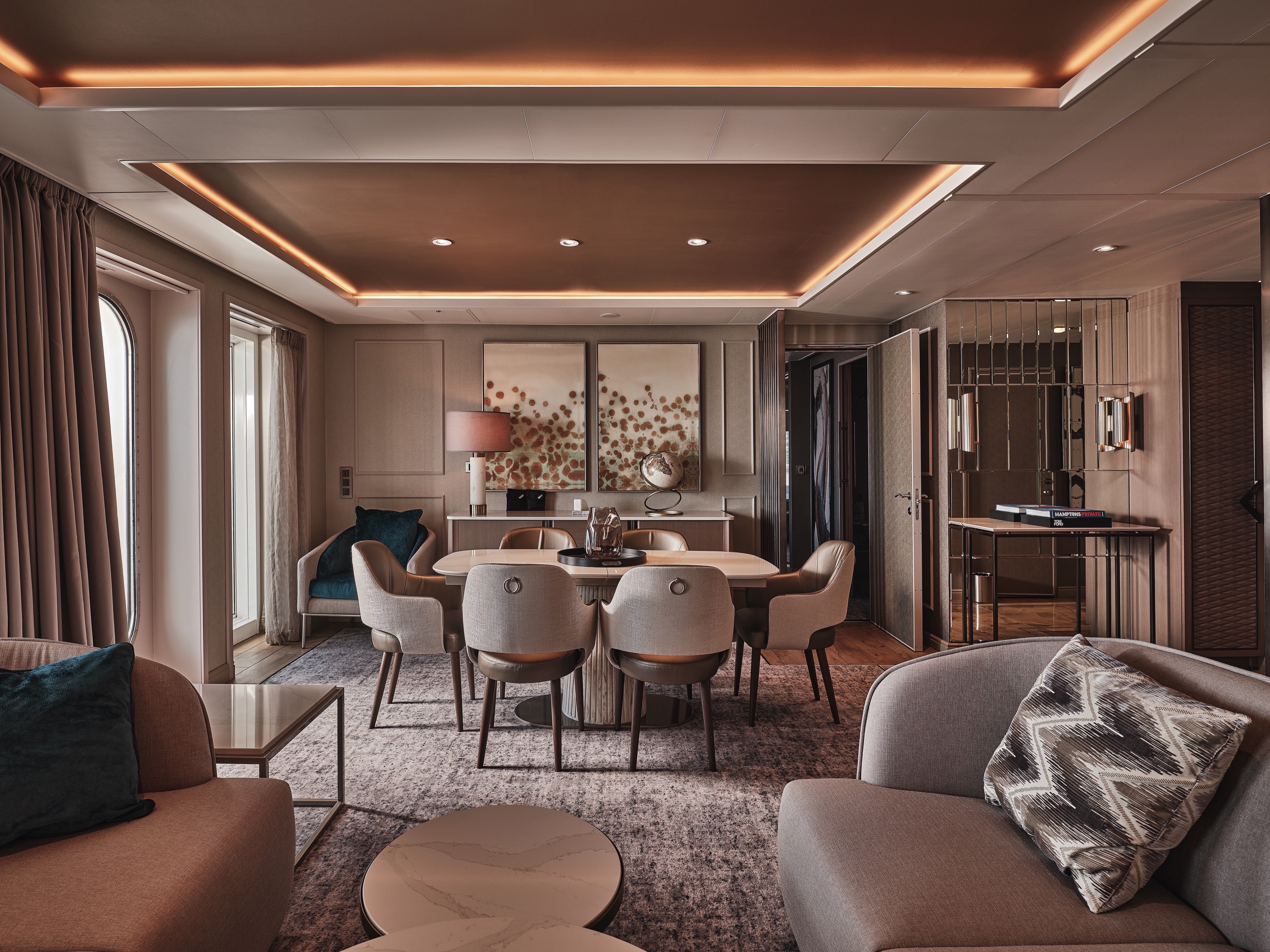
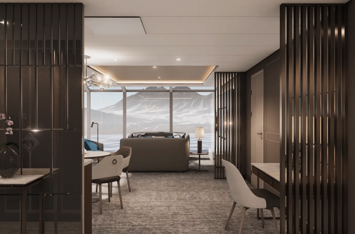
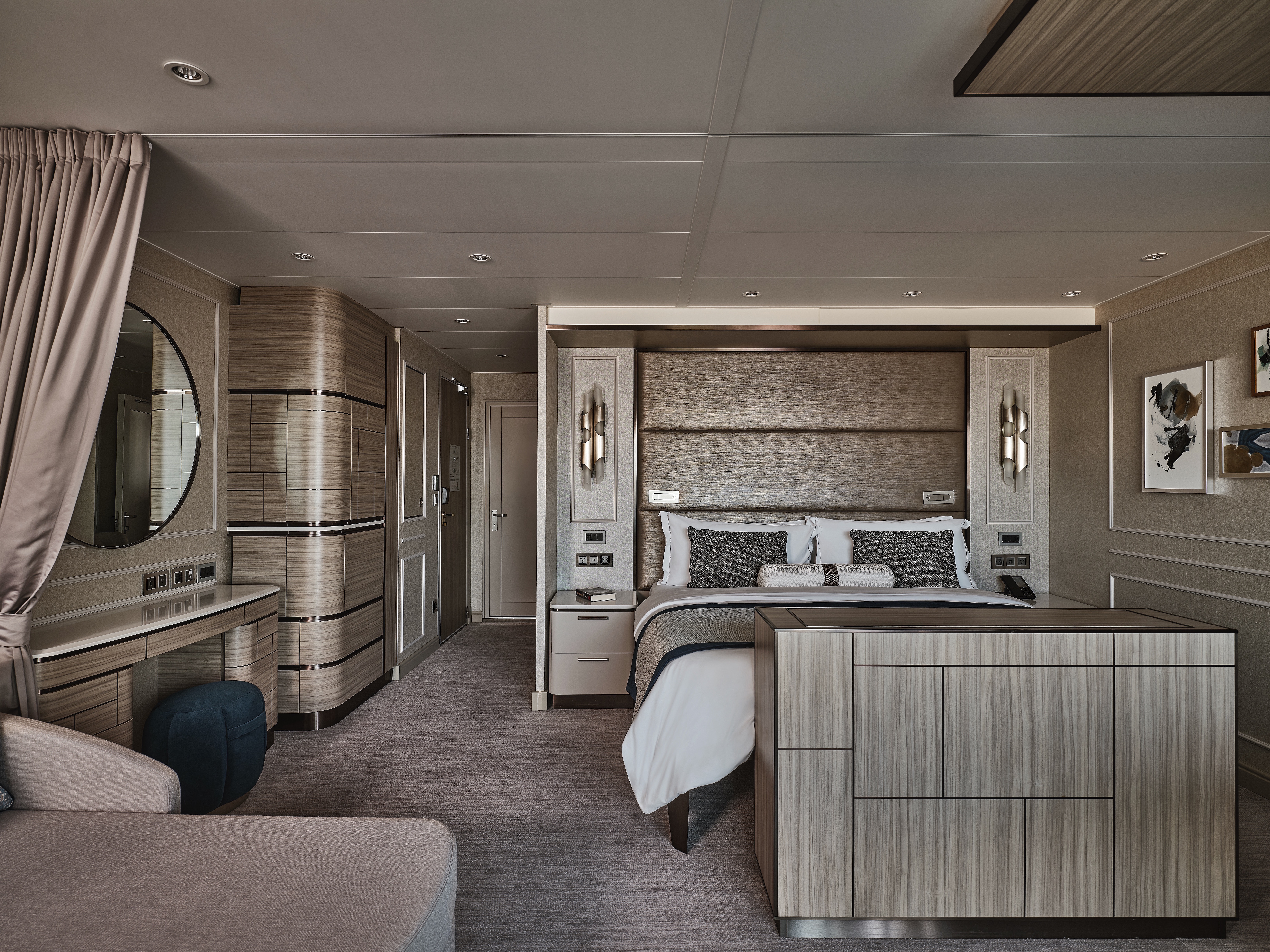
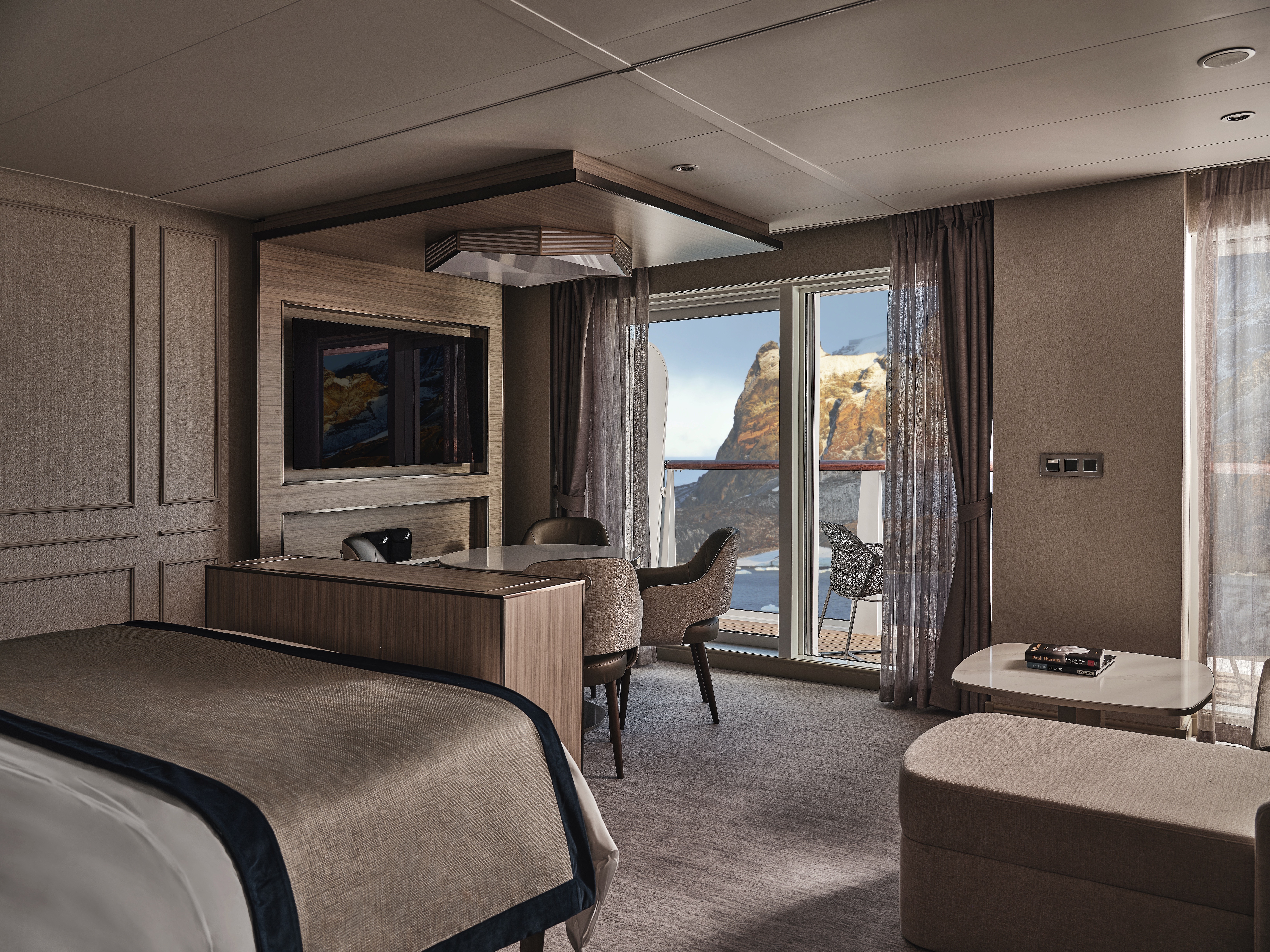
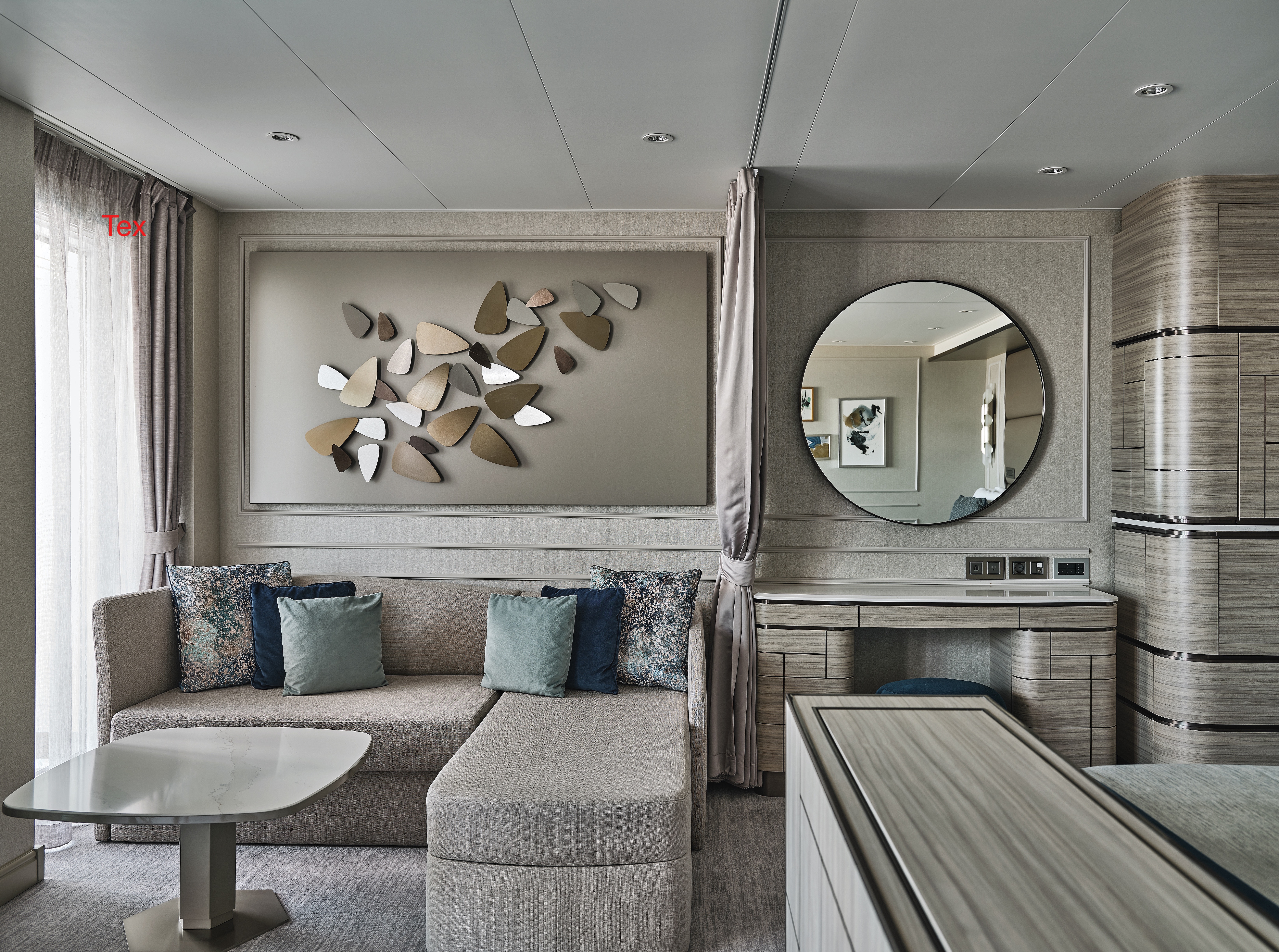
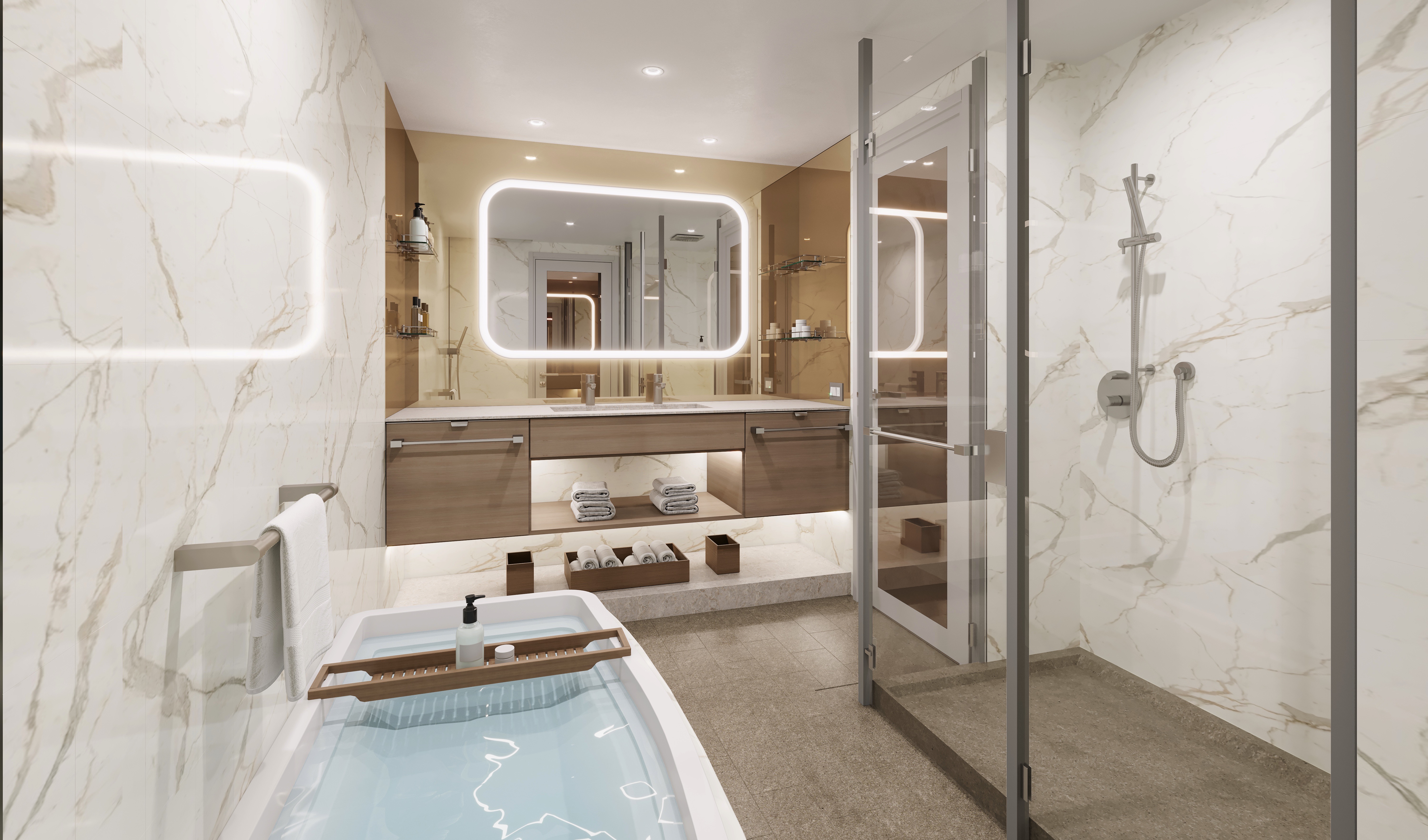
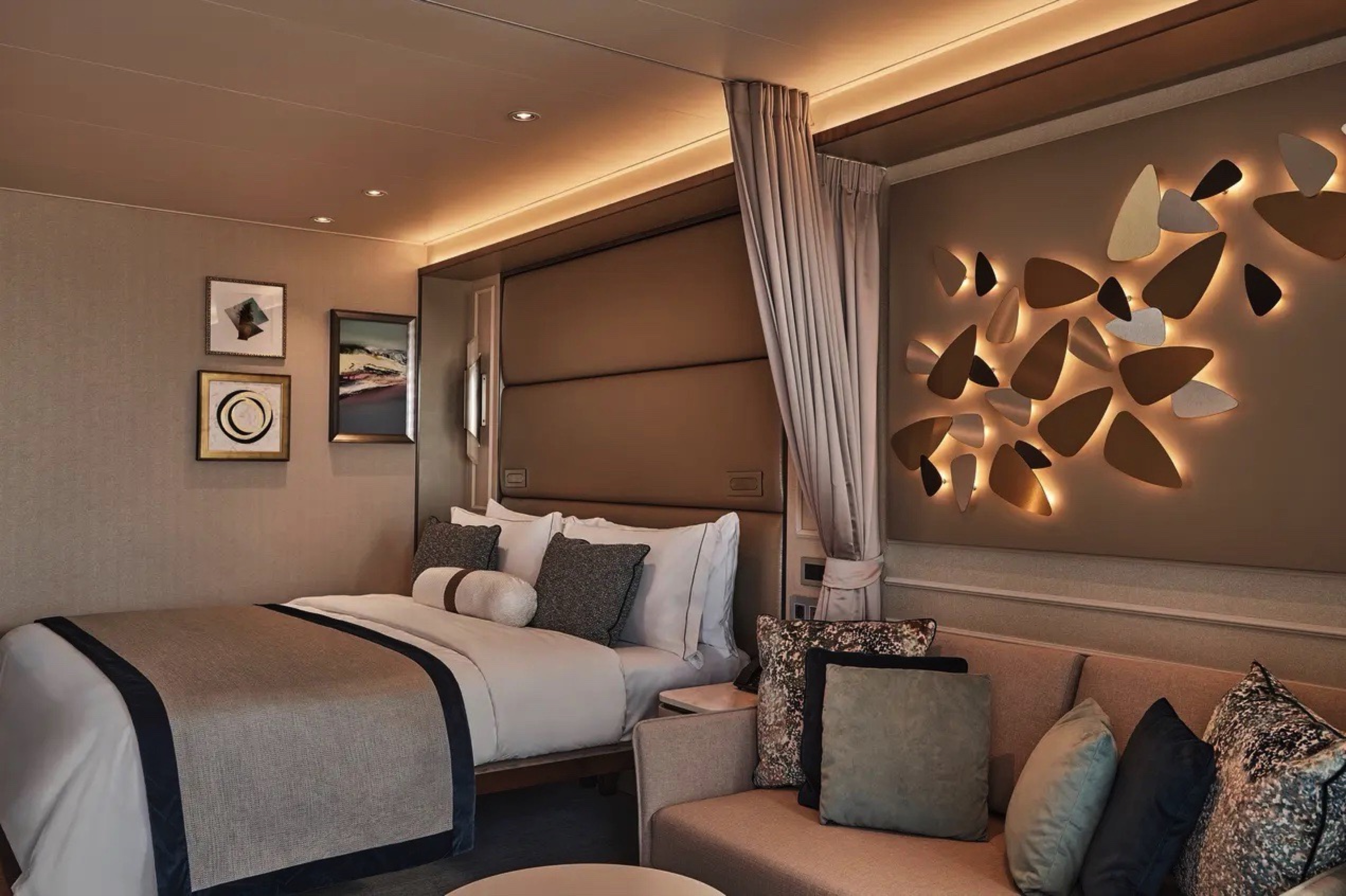
Supremely spacious and superbly located, the Owner’s Suite is the most luxurious suite on board. Located in the premium bow position on deck 7, the Owner’s Suite offers amazing destination immersion, thanks its enormous surrounding balcony and incredible views from all indoor areas. The large living room, separate dining area, and well-stocked bar are perfect for sharing a moment with like-minded travelers while the luxurious and well-appointed bedrooms ensure supreme comfort any time of the day or night.
One bedroom: 173.5 sq m including veranda (69 sq m)
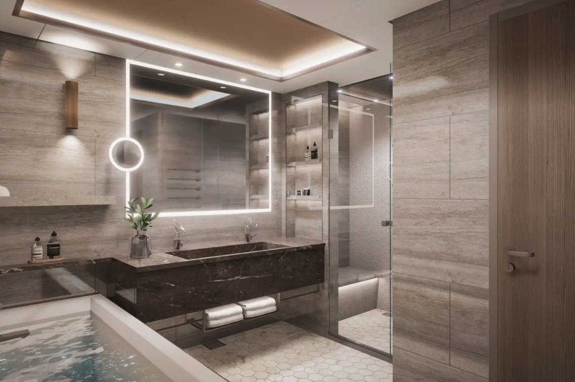
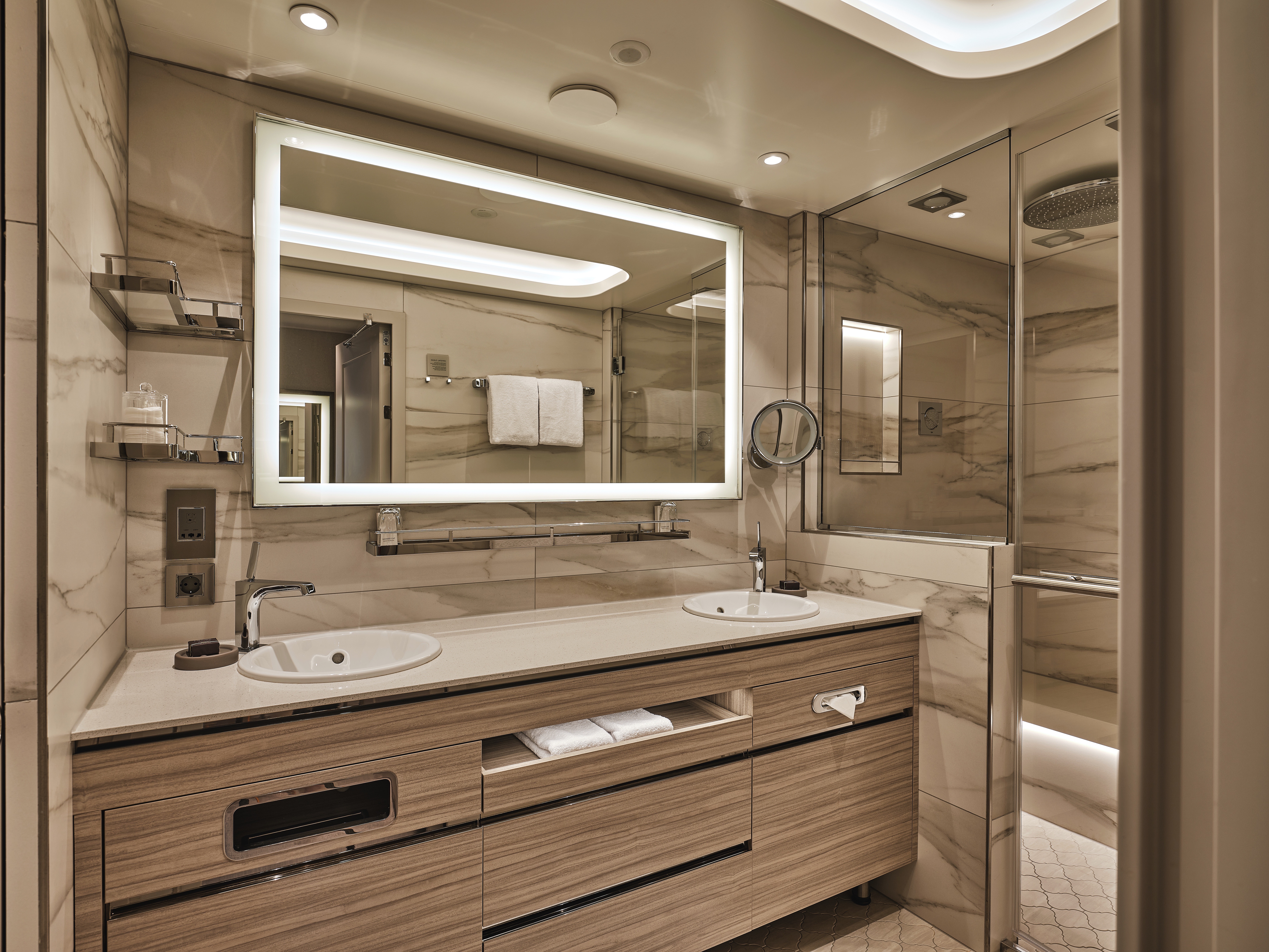
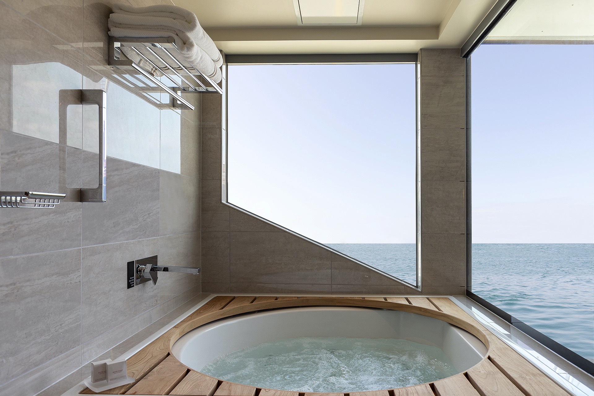
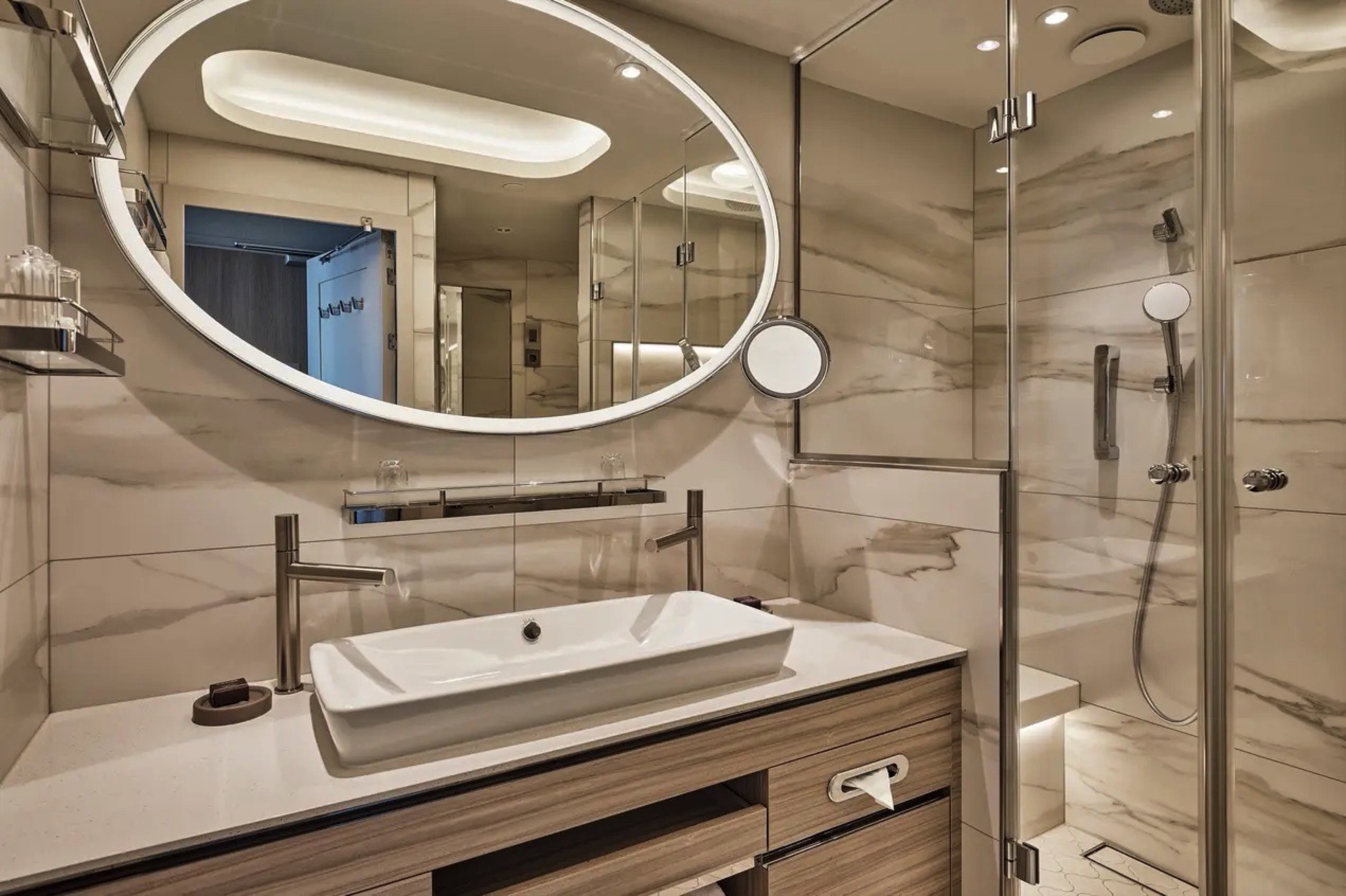
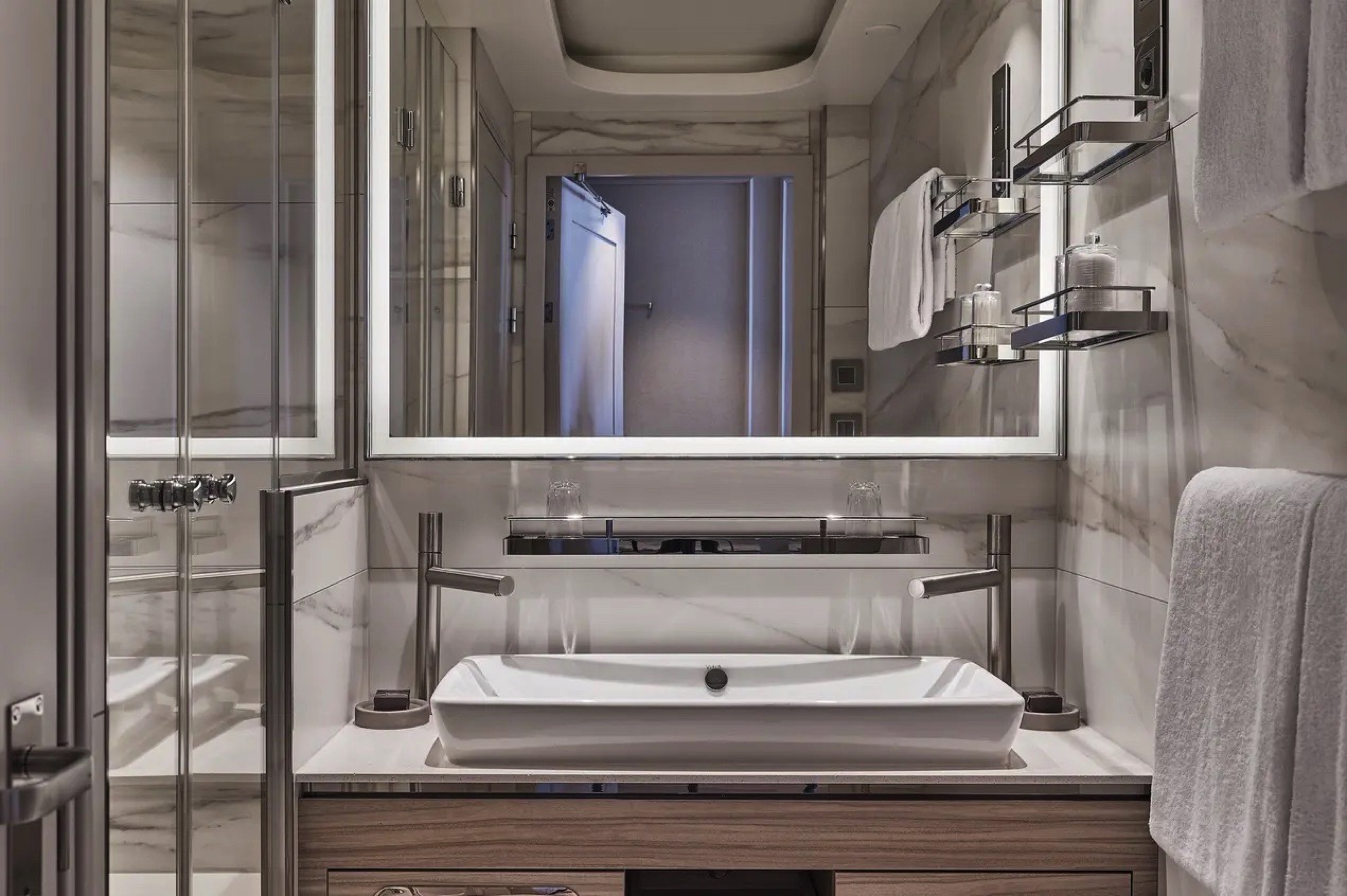
The main bedroom has a large walk-in wardrobe with a personal safe and a bathroom with a double vanity, walk-in shower, and whirlpool bath.
The second bedroom has a separate wardrobe and a bathroom with a walk-in shower.
Images are intended as a general reference. Features, materials, finishes and layout may be different than shown.
Essentials
- Deck(s): 7
- Section: Forward, Starboard
Characteristics
- Large Veranda with floor-to-ceiling glass doors
- Separate dining area
- Living room with sitting area
- Double vanity
- Walk-in shower
- Whirlpool bath
- Walk-in wardrobe with personal safe
Furniture
- Twin beds or king-size bed
- Writing desk
- Luxury bed mattresses
Media & Communication
- Unlimited Premium Wi-Fi
- 3 large flat screen TVs with Interactive Media Library
- Sound system with bluetooth connectivity
- Direct dial telephone
- Wall mounted USB-C mobile device chargers
Onboard Services
- Butler service
- Complimentary laundry, pressing & wet cleaning
- Dinner for two in La Dame, one evening per voyage,
- Two hours of worldwide phone use, per voyage segment
- Champagne on arrival
Amenities
- Espresso machine
- Pillow menu
- Refrigerator and bar setup stocked with your preferences
- Plush bathrobe
- Luxury bath amenities
- Umbrella
- Hair Dryer
- Slippers
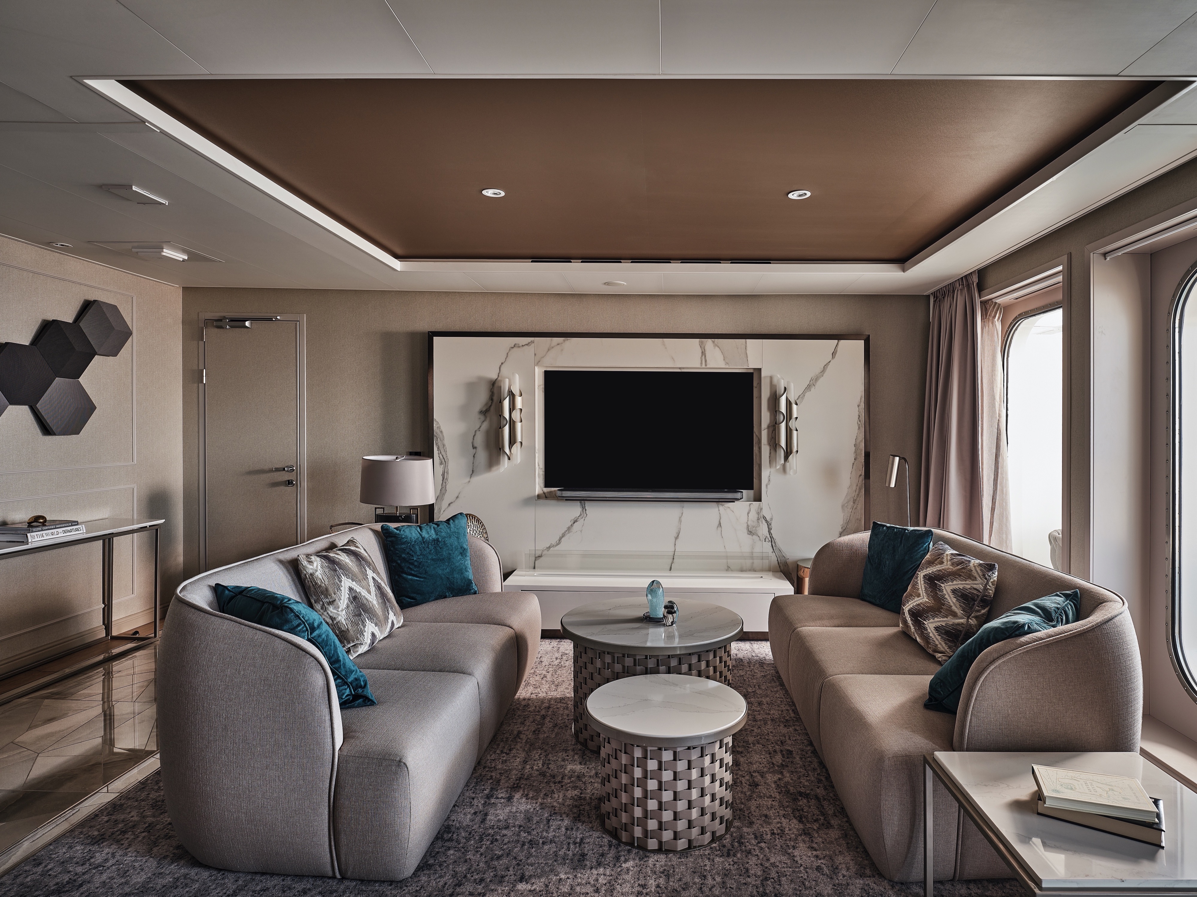
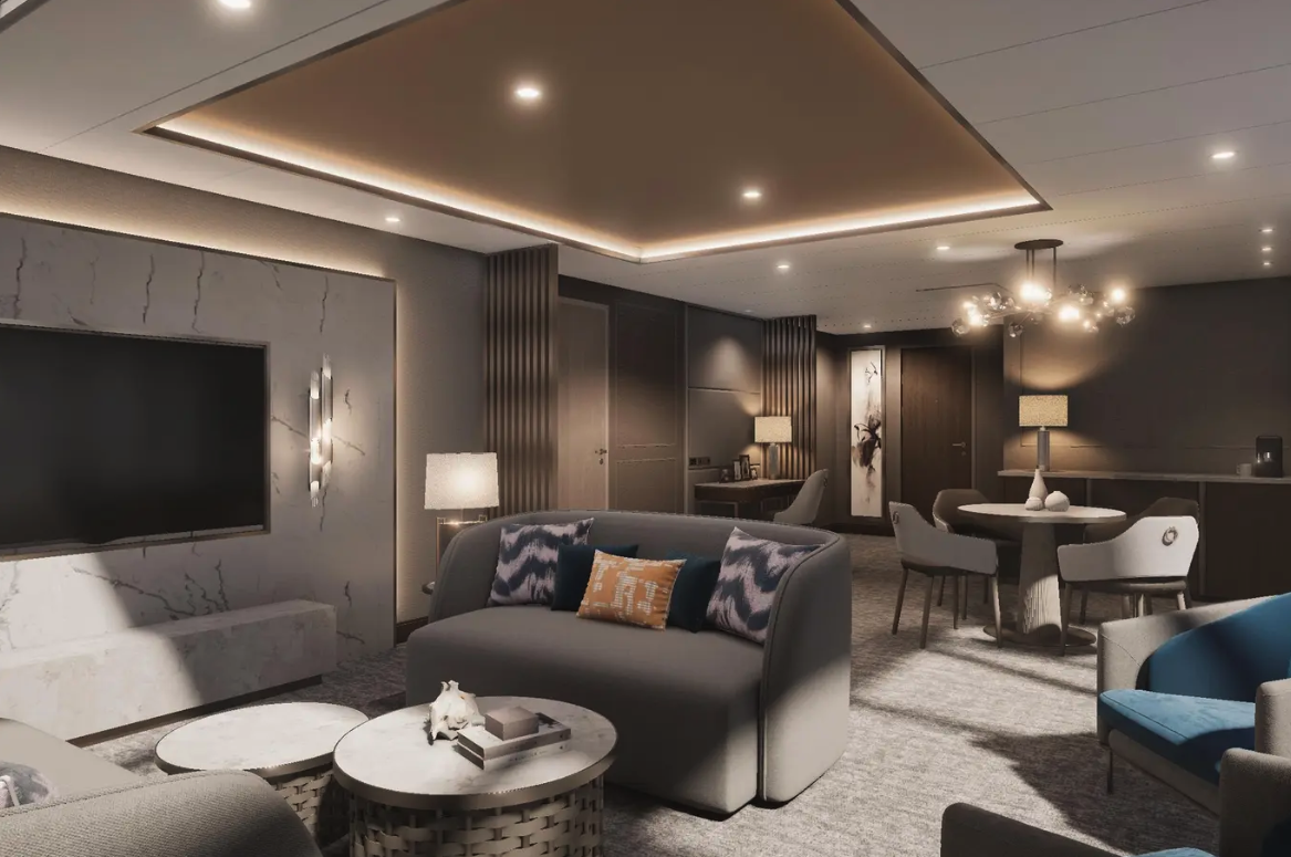
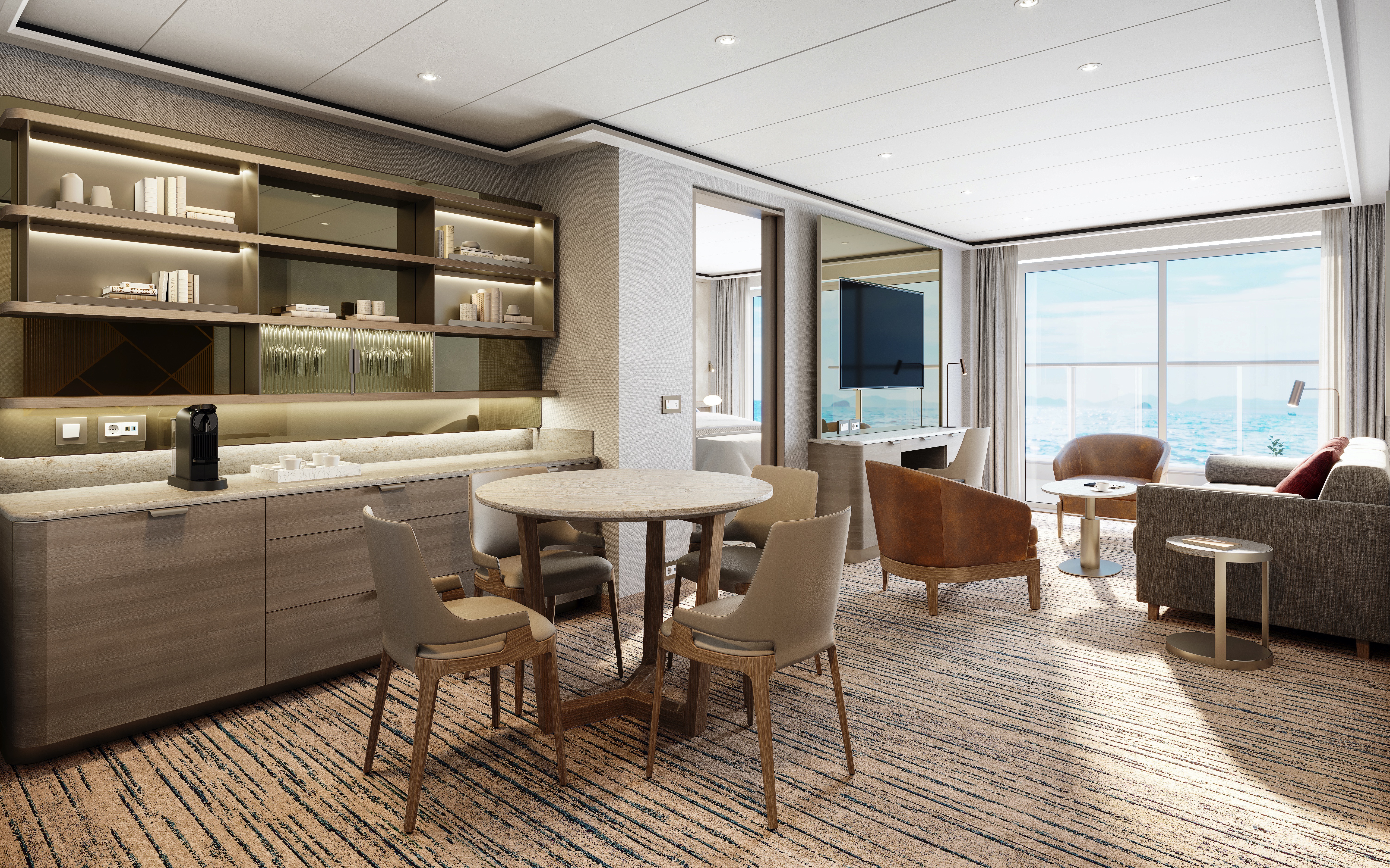
The Grand Suite is one of the most luxurious and spacious suites on board Silver Endeavour. It guarantees sweeping views of your destination thanks to its large balcony. A spacious interior includes a large living room, separate dining area, and large bedroom with a big walk-in wardrobe. A luxurious bathroom includes a double vanity, whirlpool bath, and walk-in shower. In addition, the Grand Suite also includes a small, second bedroom able to accommodate a third berth.
One bedroom: 155 sq m including veranda (64 sq m)
Two bedrooms: 188.1 sq m including veranda (69 sq m)
A third guest can be accommodated in an additional single-bed bedroom.
Images are intended as a general reference. Features, materials, finishes and layout may be different than shown.
Essentials
- Deck(s): 7
- Section: Forward, Port
Characteristics
- Large Veranda with floor-to-ceiling glass doors
- Separate dining area
- Living room with sitting area
- Double vanity
- Walk-in shower
- Whirlpool bath
- Walk-in wardrobe with personal safe
Furniture
- Twin beds or king-size bed and a single bed in additional bedroom
- Writing desk
- Vanity table
- Luxury bed mattresses
Media & Communication
- Unlimited Premium Wi-Fi
- 2 large flat screen TVs with Interactive Media Library
- Sound system with bluetooth connectivity
- Direct dial telephone
- Wall mounted USB-C mobile device chargers
Onboard Services
- Butler service
- Complimentary laundry, pressing & wet cleaning
- Dinner for two in La Dame, one evening per voyage,
- Two hours of worldwide phone use, per voyage segment
- Champagne on arrival
Amenities
- Espresso machine
- Pillow menu
- Refrigerator and bar setup stocked with your preferences
- Plush bathrobe
- Luxury bath amenities
- Umbrella
- Hair Dryer
- Slippers
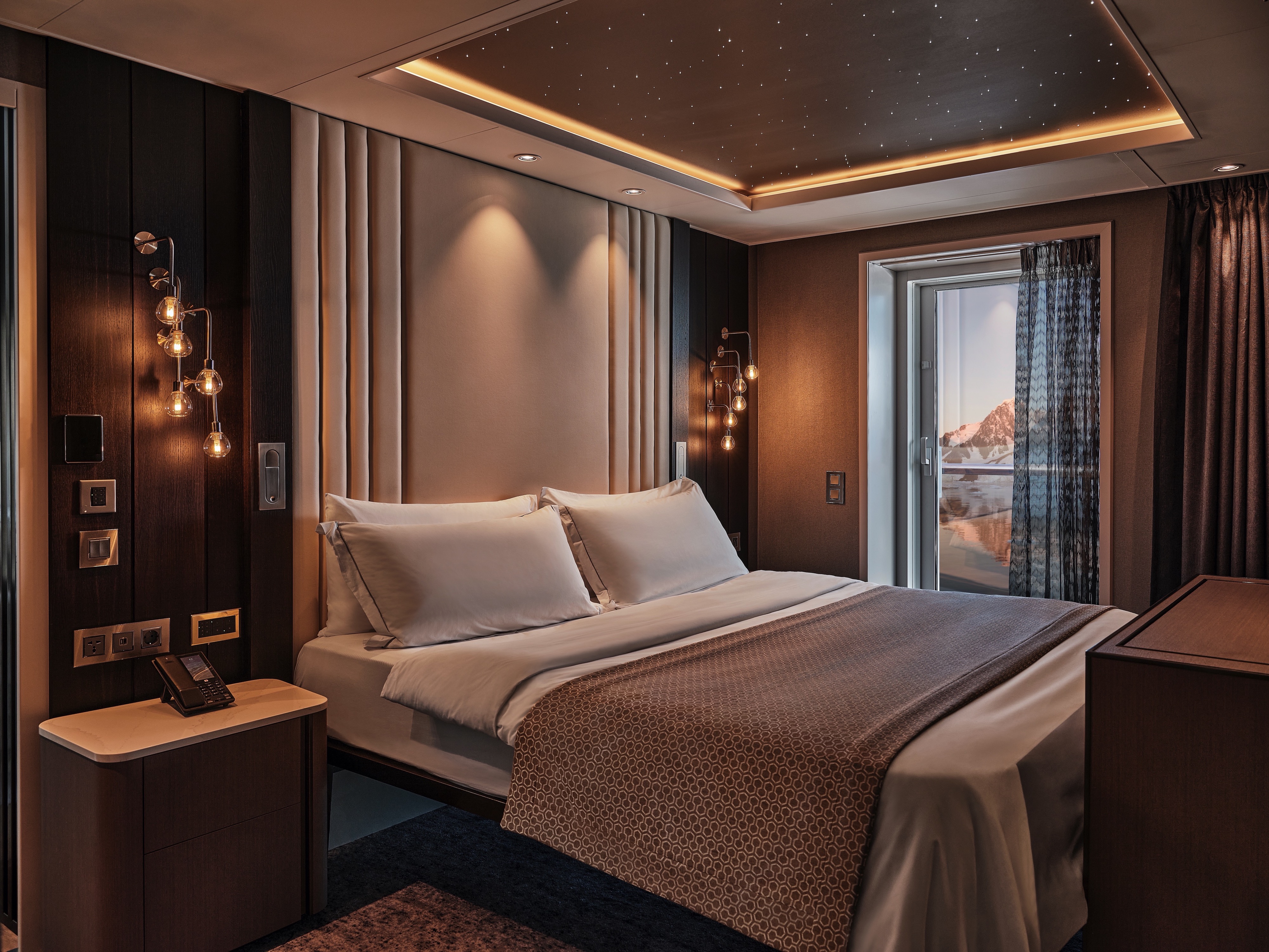
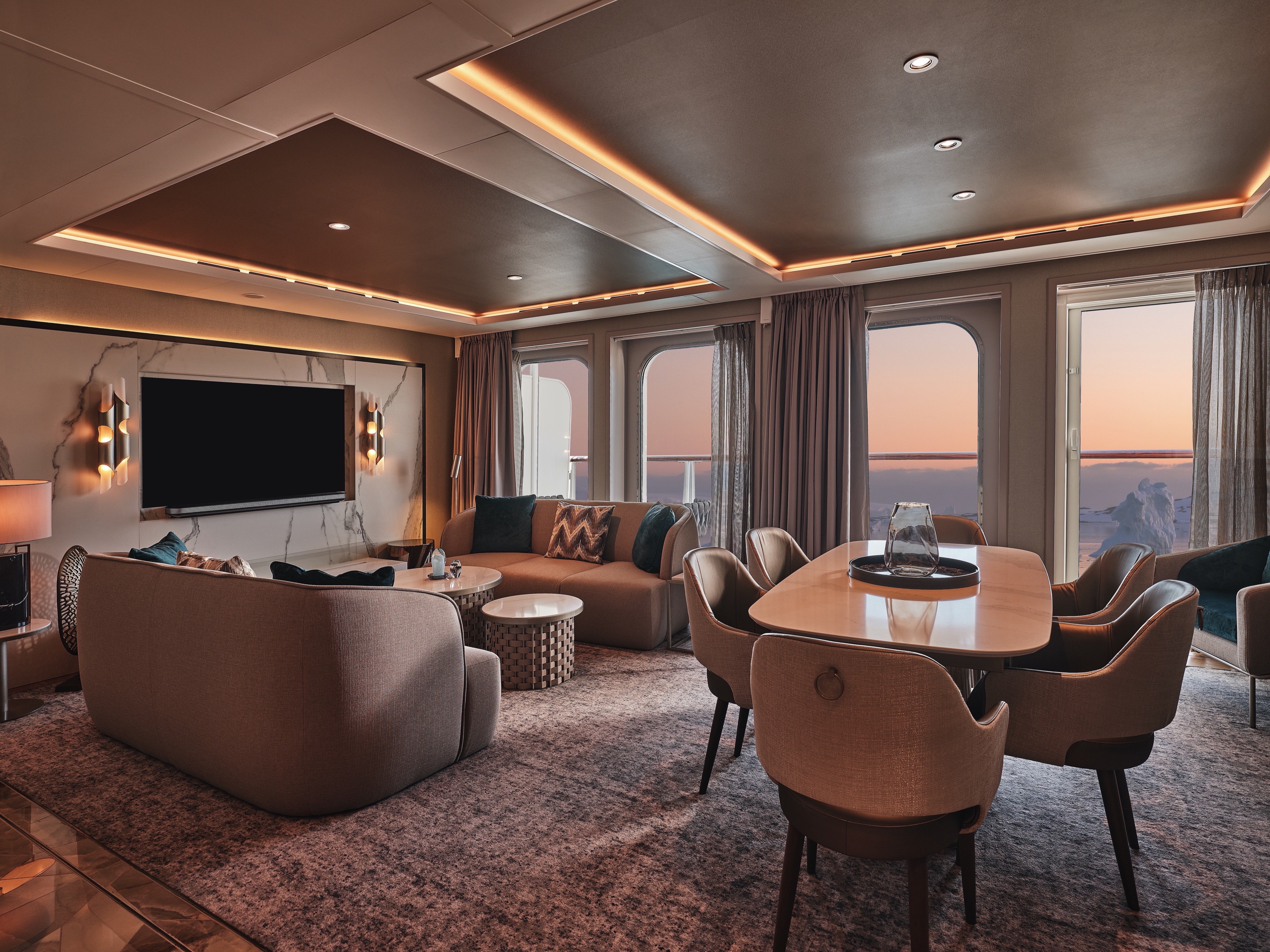
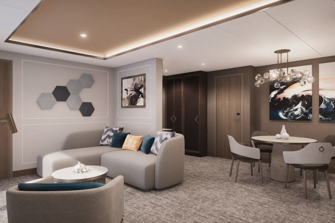
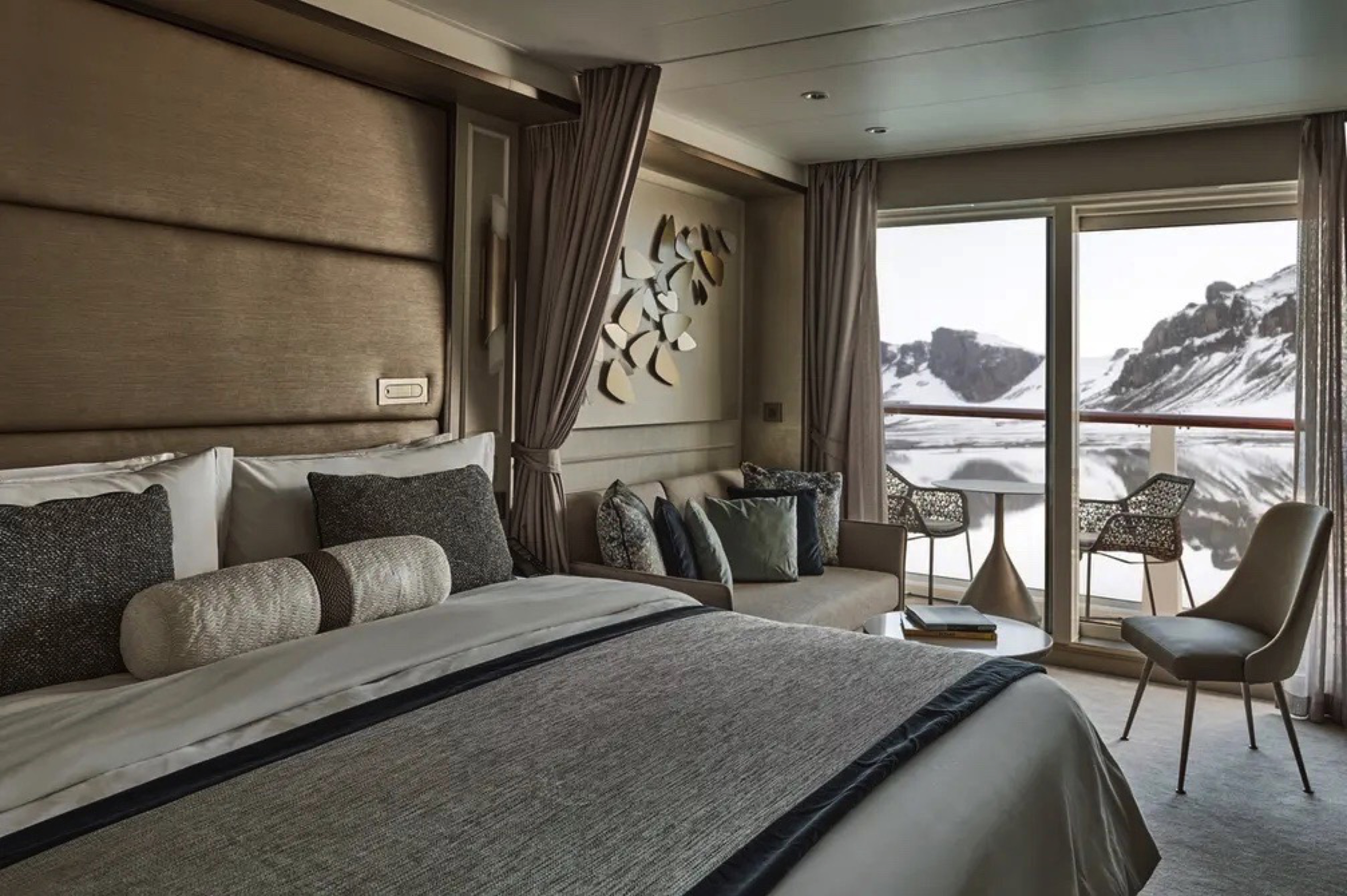
One of our most sumptuous suites ever designed! With innovative domed glazing surrounding the living areas and one of the largest balconies on board, the Master Suite offers complete destination immersion at sea. Floor-to-ceiling windows provide wow-factor 270-degree views while the beautifully appointed living and dining areas, separate bedroom, and bathroom with walk-in shower and whirlpool bath ensure complete in-suite comfort. If you have ever wanted to experience expedition travel while not missing out on luxury, Silver Endeavour’s Master Suite is the answer.
One bedroom: 108 sq m including veranda (25.8 sq m)
Images are intended as a general reference. Features, materials, finishes and layout may be different than shown.
Essentials
- Deck(s): 8
- Section: Aft
Characteristics
- Large Veranda with floor-to-ceiling glass doors
- Separate dining area
- Living room with sitting area
- Double vanity
- Walk-in shower
- Whirlpool bath
- Walk-in wardrobe with personal safe
Furniture
- King size bed
- Writing desk
- Luxury bed mattresses
Media & Communication
- Unlimited Premium Wi-Fi
- 2 large flat screen TVs with Interactive Media Library
- Sound system with bluetooth connectivity
- Direct dial telephone
- Wall mounted USB-C mobile device chargers
Onboard Services
- Butler service
- Complimentary laundry, pressing & wet cleaning
- Two hours of worldwide phone use, per voyage segment
- Champagne on arrival
Amenities
- Espresso machine
- Pillow menu
- Refrigerator and bar setup stocked with your preferences
- Plush bathrobe
- Luxury bath amenities
- Umbrella
- Hair Dryer
- Slippers
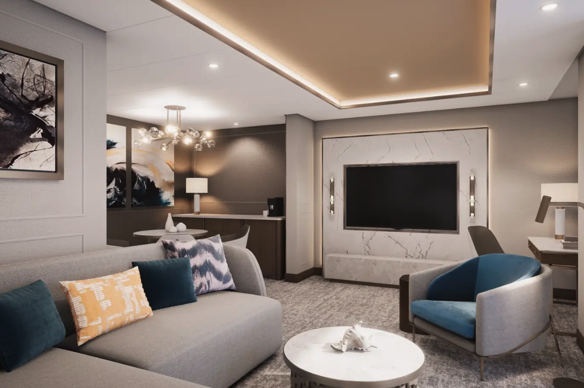
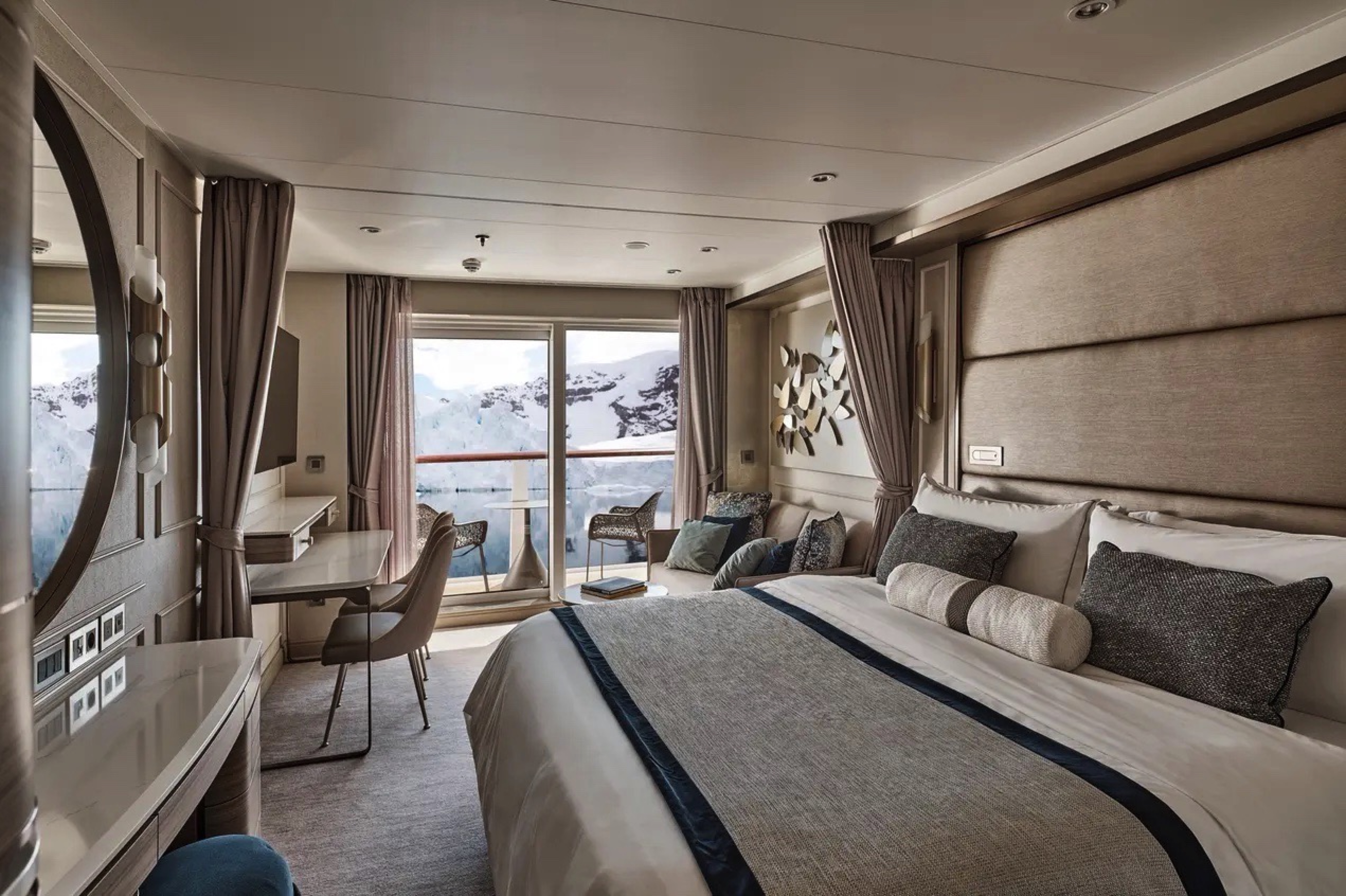
Get closer to your destination with Silver Endeavour’s Signature Suite! Located on deck 8, this beautiful accommodation offers a wonderfully large living room, a dining area, a separate bedroom, and a bathroom with walk-in shower and whirlpool bath. But surely the best thing about the Signature Suite is the huge private veranda and floor-to-ceiling glass walls, offering you sweeping views whether you are at the tip or toe of the world. The Signature Suite is one of our favorite places to enjoy serene polar landscapes after a day of onshore exploring.
One bedroom: 67–78 sq m including veranda (16–22 sq m )
Images are intended as a general reference. Features, materials, finishes and layout may be different than shown.
Essentials
- Deck(s): 8
- Section: Aft, Mid-Ship
Characteristics
- Large Veranda with floor-to-ceiling glass doors
- Separate dining area
- Living room with sitting area
- Double vanity
- Walk-in shower
- Whirlpool bath
- Walk-in wardrobe with personal safe
Furniture
- King size bed
- Writing desk
- Luxury bed mattresses
Media & Communication
- Unlimited Premium Wi-Fi
- 2 large flat screen TVs with Interactive Media Library
- Sound system with bluetooth connectivity
- Direct dial telephone
- Wall mounted USB-C mobile device chargers
Onboard Services
- Butler service
- Complimentary laundry, pressing & wet cleaning
- Two hours of worldwide phone use, per voyage segment
- Champagne on arrival
Amenities
- Espresso machine
- Pillow menu
- Refrigerator and bar setup stocked with your preferences
- Plush bathrobe
- Luxury bath amenities
- Umbrella
- Hair Dryer
- Slippers

No Silversea ship would be complete without our guests’ favorite Silver Suite. Located on deck 8, the Silver Suite promises stunning views of the destination thanks to its floor-to-ceiling window and large balcony. The spacious living area allows for comfortable relaxation while the dining area makes cozy nights in veritable experiences in themselves. Additionally, Silver Suites feature generous walk-in wardrobes as well as a bathroom with a large walk-in shower, vanity, and separate lavatory.
One bedroom: 49.7 sq m including veranda (7 sq m)
Please note that the third guest will sleep on a comfortable sofa bed in the reception area of the suite.
Images are intended as a general reference. Features, materials, finishes and layout may be different than shown.
Essentials
- Deck(s): 8
- Section: Mid-Ship
Characteristics
- Veranda
- Separate dining area
- Living room with sitting area
- Double vanity
- Walk-in shower
Furniture
- Writing desk
- Vanity table
- Luxury bed mattresses
Media & Communication
- Unlimited Premium Wi-Fi
- 2 large flat screen TVs with Interactive Media Library
- Sound system with bluetooth connectivity
- Direct dial telephone
- Wall mounted USB-C mobile device chargers
Onboard Services
- Butler service
- Complimentary laundry, pressing & wet cleaning
- Champagne on arrival
Amenities
- Espresso machine
- Pillow menu
- Refrigerator and bar setup stocked with your preferences
- Plush bathrobe
- Luxury bath amenities
- Umbrella
- Hair Dryer
- Slippers
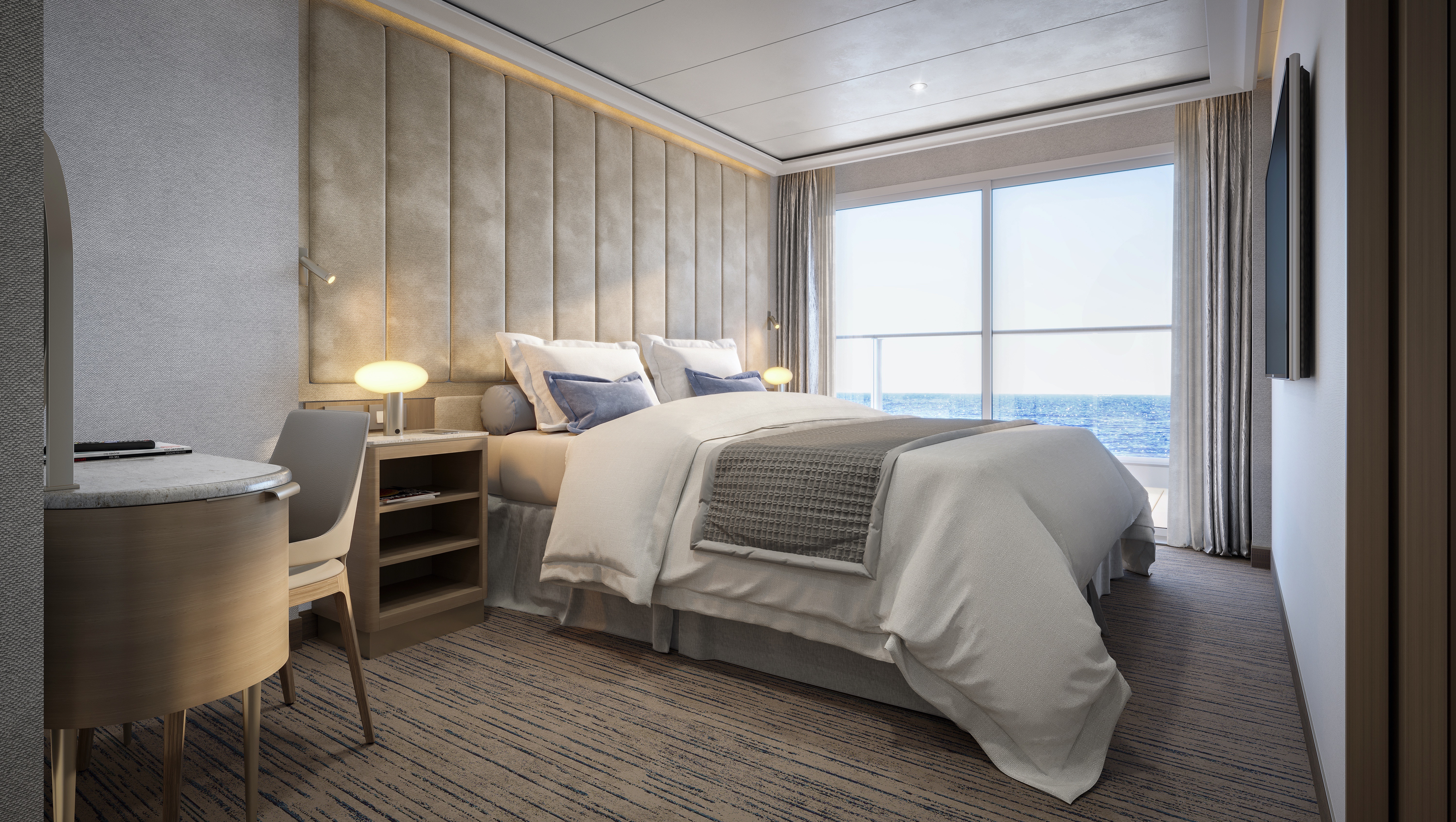
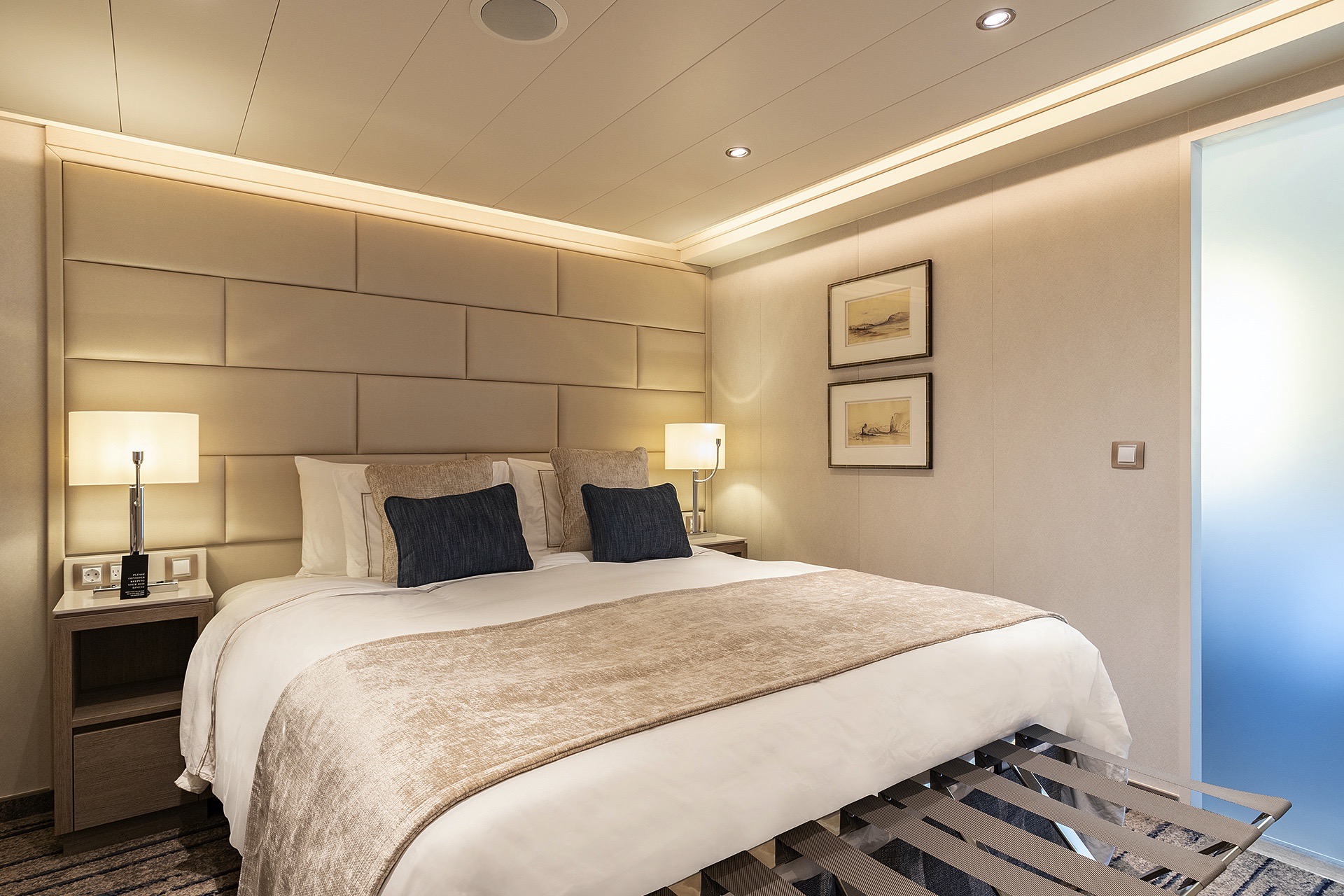
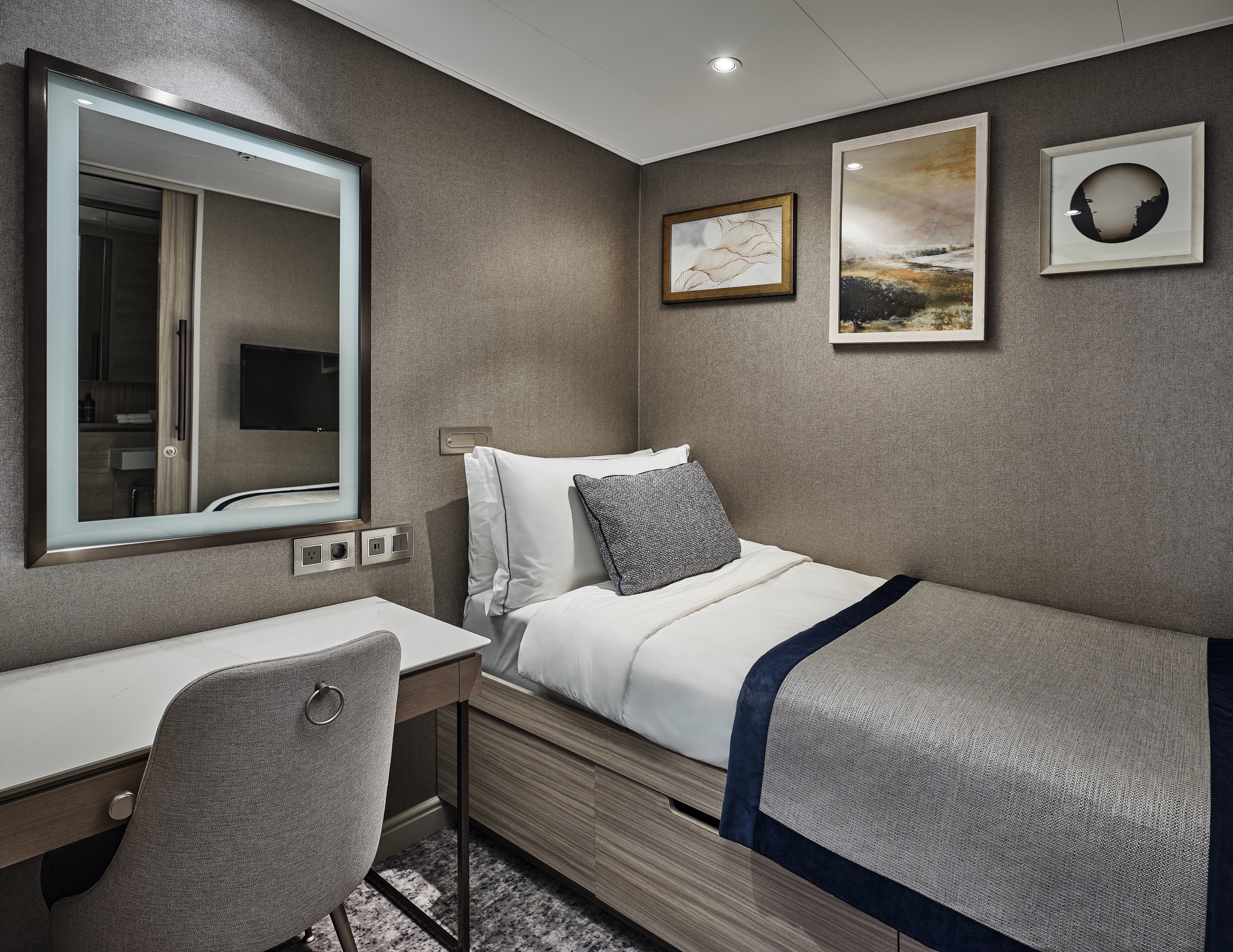
Our best-selling Premium Veranda Suite is more beautiful and luxurious than ever on board Silver Endeavour. This suite offers a large bedroom space with dreamy bedding, a stunning marbled bathroom with a large vanity, and sumptuous walk-in shower. Comfortable furnishings and elegant decor make staying in (almost) as good as going out! Spacious and well-situated, enjoy ultra-luxury amenities from the 24-hour butler service to the well-stocked mini-bar (and yes, they’re all included!). The sofa bed can easily accommodate a third guest.
One bedroom: 33.1 sq m including veranda (5 sq m)
Please note that the third guest will sleep on a comfortable sofa bed in the reception area of the suite.
Images are intended as a general reference. Features, materials, finishes and layout may be different than shown.
Essentials
- Deck(s): 6, 7
- Section: Forward, Mid-Ship
Characteristics
- Veranda
- Sitting area
- Large vanity
- Walk-in shower
Furniture
- King size bed
- Writing desk
- Vanity table
- Luxury bed mattresses
Media & Communication
- Unlimited Standard Wi-Fi
- 1 large flat screen TV with Interactive Media Library
- Direct dial telephone
- Wall mounted USB-C mobile device chargers
Onboard Services
- Butler service
- Champagne on arrival
Amenities
- Pillow menu
- Refrigerator and bar setup stocked with your preferences
- Plush bathrobe
- Luxury bath amenities
- Umbrella
- Hair Dryer
- Slippers
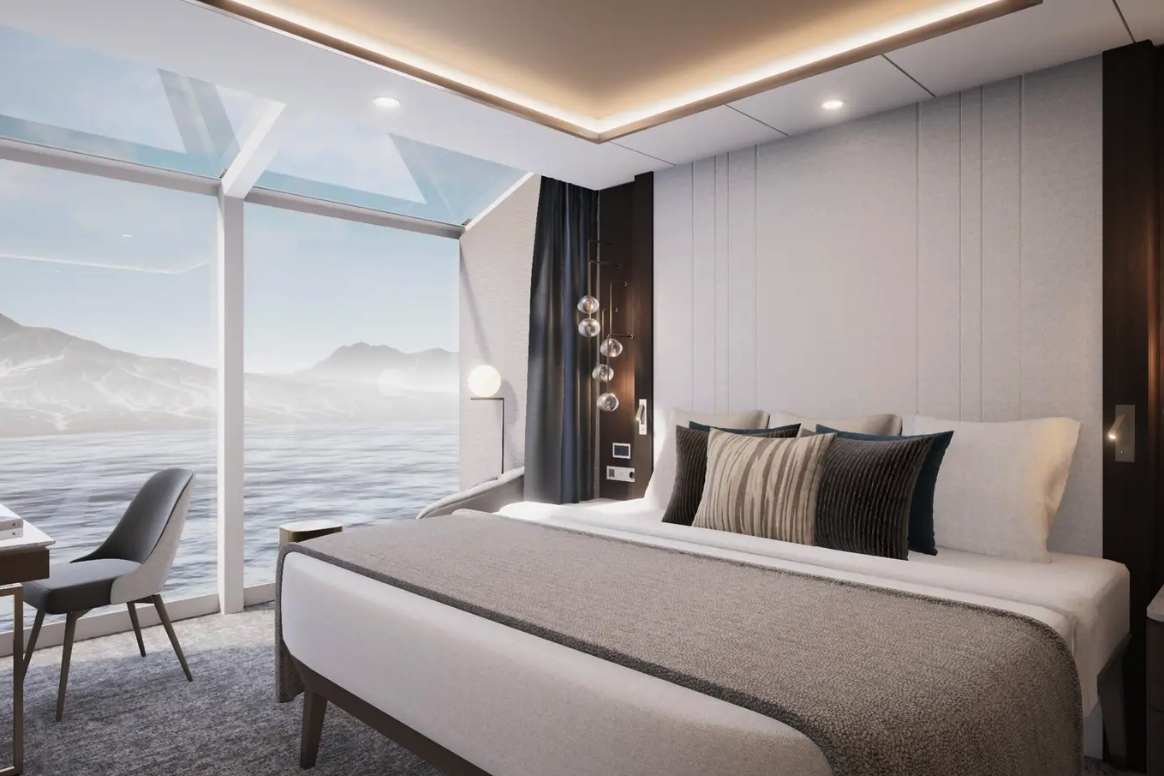
Deluxe Veranda Suites keep the iconic suite configuration—one of the most successful in the industry—while enhancing your creature comforts and destination immersion. Located on the privileged upper-mid levels, Deluxe Veranda Suites have spacious interiors with a bedroom area that includes a large writing desk and comfortable living room with a convertible sofa (able to accommodate a third berth). Even better, the balcony is larger and more beautiful than ever, offering ample space to relax and enjoy sweeping views, wherever you are.
One bedroom: 33.1 sq m including veranda (5 sq m)
Please note that the third guest will sleep on a comfortable sofa bed in the reception area of the suite.
Images are intended as a general reference. Features, materials, finishes and layout may be different than shown.
Essentials
- Deck(s): 6, 7
- Section: Aft, Mid-Ship
Characteristics
- Veranda
- Sitting area
- Large vanity
- Walk-in shower
Furniture
- King size bed
- Writing desk
- Vanity table
- Luxury bed mattresses
Media & Communication
- Unlimited Standard Wi-Fi
- 1 large flat screen TV with Interactive Media Library
- Direct dial telephone
- Wall mounted USB-C mobile device chargers
Onboard Services
- Butler service
- Champagne on arrival
Amenities
- Pillow menu
- Refrigerator and bar setup stocked with your preferences
- Plush bathrobe
- Luxury bath amenities
- Umbrella
- Hair Dryer
- Slippers
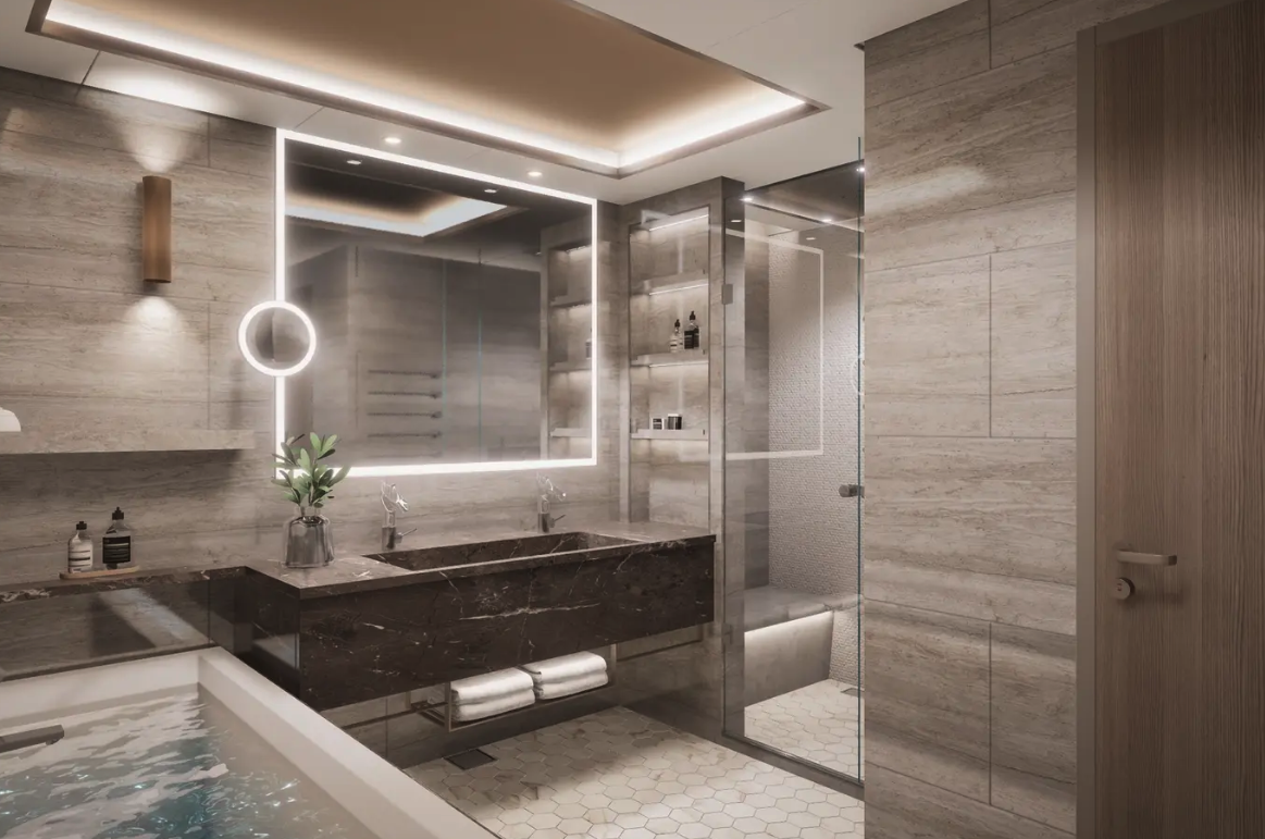
The Superior Veranda Suite is found on the upper decks. From the sumptuous views from the teak veranda to the spacious sitting room (with a sofa bed able to accommodate a third berth) and large marble bathroom, everything about the Superior Veranda has been designed for your comfort. A comfortable living space, attention to detail, and a generous expanse of amenities make this stunning suite a cozy home while on the seas.
One bedroom: 33.1 sq m including veranda (5 sq m)
Please note that the third guest will sleep on a comfortable sofa bed in the reception area of the suite.
Images are intended as a general reference. Features, materials, finishes and layout may be different than shown.
Essentials
- Deck(s): 6, 7, 8
- Section: Aft, Forward, Mid-Ship
Characteristics
- Veranda
- Sitting area
- Large vanity
- Walk-in shower
Furniture
- King size bed
- Writing desk
- Vanity table
- Luxury bed mattresses
Media & Communication
- Unlimited Standard Wi-Fi
- 1 large flat screen TV with Interactive Media Library
- Direct dial telephone
- Wall mounted USB-C mobile device chargers
Onboard Services
- Butler service
- Champagne on arrival
Amenities
- Pillow menu
- Refrigerator and bar setup stocked with your preferences
- Plush bathrobe
- Luxury bath amenities
- Umbrella
- Hair Dryer
- Slippers
Located on the lower decks in the bow, the Classic Veranda Suite offers all the comfort and attention to detail that you can expect aboard—both inside and out. A generous expanse of interior comforts—elegant decor, a stunning marble bathroom, and ample seating area (with a sofa bed that is able to accommodate a third berth)—offers everything you need for a comfortable cruise. But perhaps this suite’s finest asset lies just outside, as floor-to-ceiling glass doors open onto a private veranda, making every sunset feel as if it is yours alone.
One bedroom: 33.1 sq m including veranda (5 sq m)
Wheelchair accessible suite: 508. The suite has a bathroom with vanity and shower.
Please note that the third guest will sleep on a comfortable sofa bed in the reception area of the suite.
Images are intended as a general reference. Features, materials, finishes and layout may be different than shown.
Essentials
- Deck(s): 5, 6
- Section: Forward, Mid-Ship
Characteristics
- Veranda
- Sitting area
- Large vanity
- Walk-in shower
Furniture
- King size bed
- Writing desk
- Vanity table
- Luxury bed mattresses
Media & Communication
- Unlimited Standard Wi-Fi
- 1 large flat screen TV with Interactive Media Library
- Direct dial telephone
- Wall mounted USB-C mobile device chargers
Onboard Services
- Butler service
- Champagne on arrival
Amenities
- Pillow menu
- Refrigerator and bar setup stocked with your preferences
- Plush bathrobe
- Luxury bath amenities
- Umbrella
- Hair Dryer
- Slippers
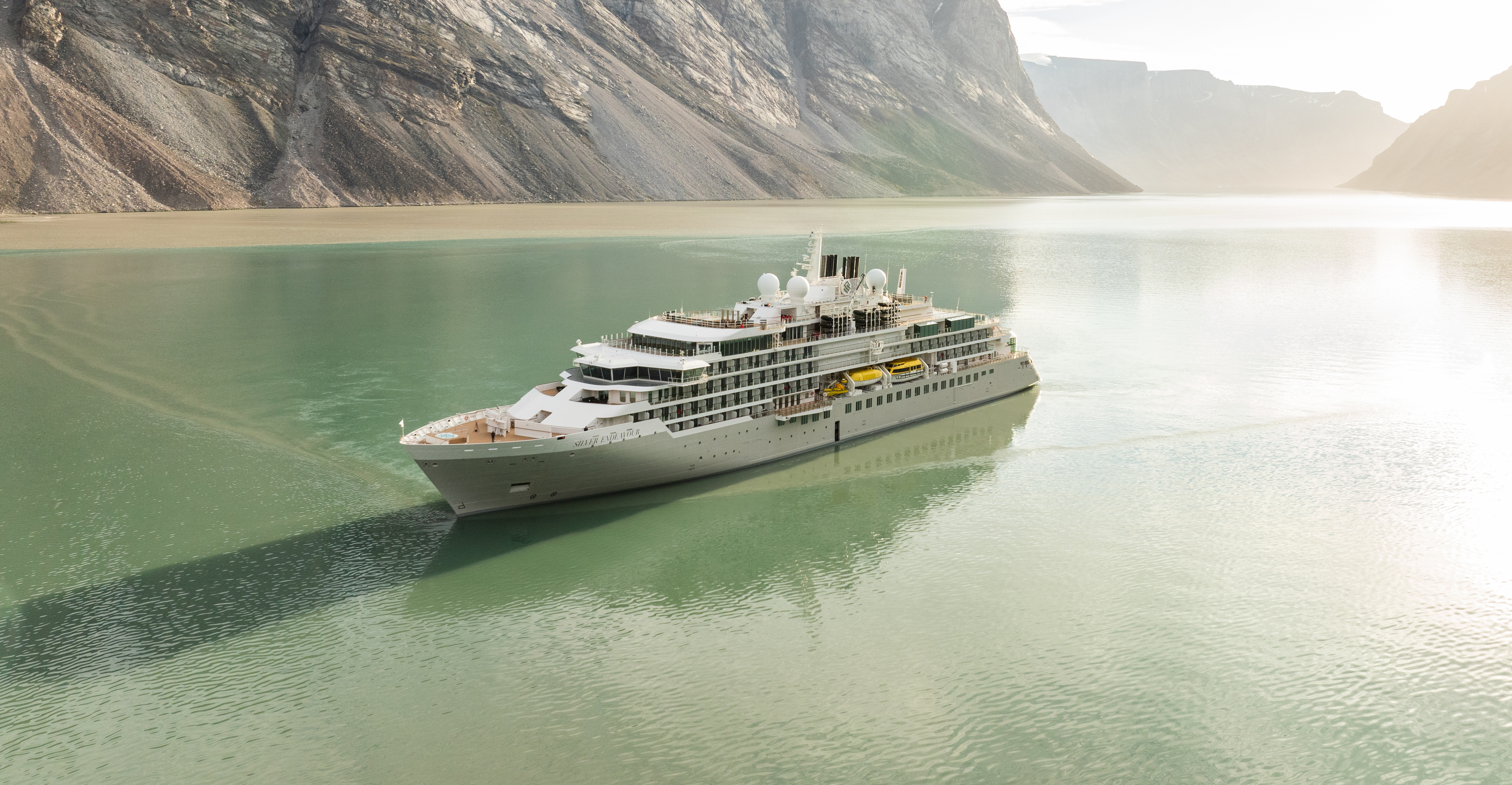
Silver Endeavour
Designed for polar exploration, Silver Endeavour is the new definition of luxury expedition travel.
We’re proud to announce that our newest addition has joined the fleet. Silver Endeavour revolutionizes our expedition voyages and allows deeper travel to some of the planet’s farthest-flung coasts. Her statistics speak for themselves: unrivaled, industry-leading crew-to-guest, Zodiac-to-guest, and expert-to-guest ratios, cutting-edge navigation and exploration technology, and hallmark Silversea comfort make her the most luxurious expedition ship ever built
EMBRACE NEW LIMITS. TRAVEL TO THE ENDS OF THE EARTH ABOARD SILVER ENDEAVOUR.
Sailing to both poles, Silver Endeavour redefines the meaning of ultra-luxury expedition cruising. Her PC6 ice-class rating is one of the highest in the industry while her state-of-the-art equipment and exploration technology offer one of the most advanced expedition experiences ever. Silver Endeavour introduces a new era in ultra-luxury expedition cruising and brings the remote and remarkable to you in hallmark Silversea comfort. Join us for endless possibilities both on board and on land aboard Silver Endeavour, the most luxurious expedition ship at sea.
EMBRACE NEW LIMITS
Travel to the ends of the Earth aboard Silver Endeavour. Sailing to both poles, our newest ship redefines the meaning of ultra-luxury expedition cruising. Her PC6 ice-class rating is among the highest in the industry, while her state-of-the-art equipment and exploration technology offer one of the most advanced expedition experiences ever. Silver Endeavour introduces a new era in ultra-luxury expedition cruising and brings the remote and remarkable to you in hallmark Silversea comfort. Join us for endless possibilities both on board and on land Silver Endeavour, the most luxurious expedition ship at sea.
Ship Facts
| Launch Year | 2021 | ||||||||
| Refit Year | |||||||||
| Language | en | ||||||||
| Gross Tonnage | 20649 | ||||||||
| Length | 165 | ||||||||
| Width | 25 | ||||||||
| Currency | USD | ||||||||
| Speed | 19 | ||||||||
| Capacity | 220 | ||||||||
| Crew Count | 207 | ||||||||
| Deck Count | 8 | ||||||||
| Cabin Count | 110 | ||||||||
| Large Cabin Count | N/A | ||||||||
| Wheelchair Cabin Count | N/A | ||||||||
| Electrical Plugs |
|
Deck 10
- Sun Deck

Deck 9
- Observation Lounge
- Library

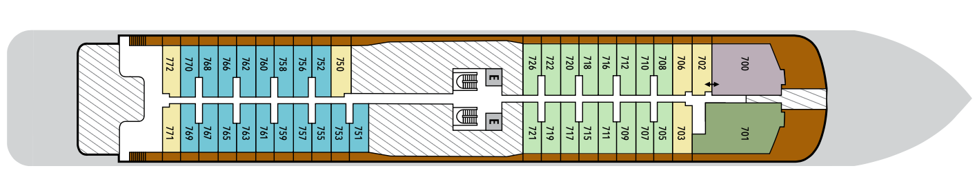
Deck 8
- Master Suite
- Superior Veranda Suite
- Signature Suite
- Silver Suite
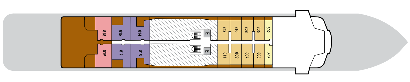
Deck 7
- Owner's Suite
- Grand Suite
- Premium Veranda Suite
- Deluxe Veranda Suite
- Superior Veranda Suite
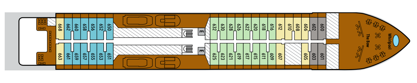
Deck 6
- Whirlpool
- The Bow
- Classic Veranda Suite
- Premium Veranda Suite
- Superior Veranda Suite
- Deluxe Veranda Suite
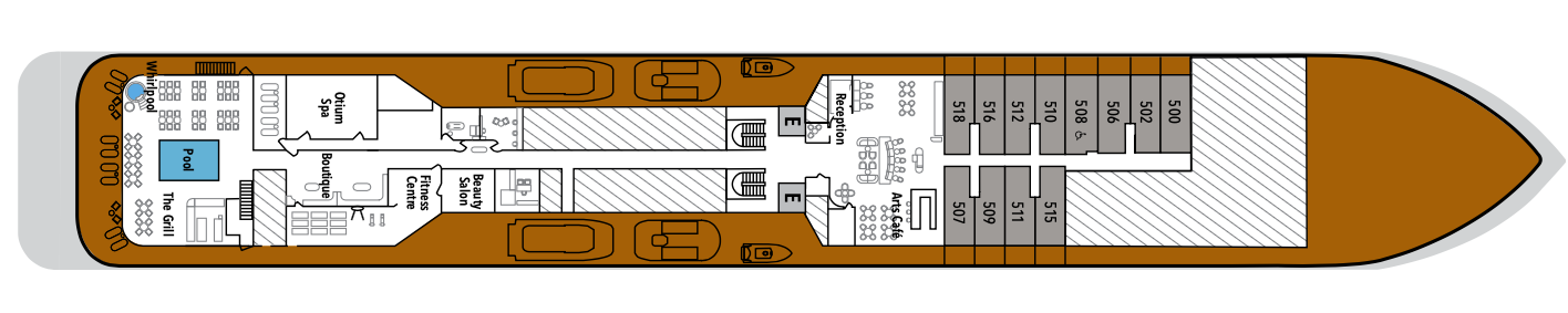
Deck 5
- Classic Veranda Suite
- Arts Café
- Beauty Salon
- Reception
- Future Cruise Sales
- Fitness Centre
- Otium Spa
- Boutique
- Pool Deck
- The Grill
- Whirlpool
Deck 4
- Medical Centre
- Explorer Lounge
- La Dame
- Connoisseur's Corner
- II Terrazzino
- The Restaurant
Deck 3
- Mud Room
- Marina
- Launderette
Dive into a world of fine dining aboard Silver Endeavour. Enjoy haute cuisine at the tip and toe of the world, dining in some of the most remote and remarkable destinations on the planet. Enjoy authentic Italian recipes that span generations in Il Terrazzino. Or why not get lost in the glacial views of The Grill while you savor some of the best international options at sea. Our famous La Dame French restaurant promises exquisite gastronomie à la française in both polar regions, while the Arts Café is the place to be for healthy daytime treats. Whether you’re in the Arctic or Antarctica, dining aboard Silver Endeavour promises to be quite special.
II Terrazzino
Italy’s world-famous cuisine reaches its farthest clientele yet aboard Silver Endeavour. Enjoy the country’s greatest dishes and authentic recipes in this edited version of our famous La Terrazza concept. Small in size but not in flavors, Il Terrazzino offers mouthwatering Italian meals in an elegant setting. Menu highlights change on a regular basis but always feature high-quality, fresh ingredients, which have made this dining option so popular throughout our entire fleet. If you like authentic Italian dishes served in a small and intimate setting, then Il Terrazzino is for you.
Images are intended as a general reference. Features, materials, finishes and layout may be different than shown.
The Restaurant
Silver Endeavour’s main dining experience weaves a sensorial tapestry of tasty memories. We promise you’ll love this remarkable venue, from the timeless decor and the warm, elegant ambience to the exceptional wine selection and the subtle, refined dishes. Enjoy regional specialties whether you’re at the tip or toe of the world, along with timeless classics that never go out of fashion. The Restaurant offers open-seating dining, which means there are no assigned times, no assigned tables. You are free to dine when, where, and with whom you please.
Images are intended as a general reference. Features, materials, finishes and layout may be different than shown.
The Grill
Welcome to one of the most impressive dining rooms at sea. The Grill aboard Silver Endeavour puts the amaze into amazing. Admire impressive views from day to night as snowy landscapes give way to starlit skies. This glass-ceilinged indoor venue offers flavorsome international meals cooked to perfection in a casual, informal atmosphere. This must-visit venue is always a favorite, whatever time of the day you dine. No jacket required!
Images are intended as a general reference. Features, materials, finishes and layout may be different than shown.
La Dame
Prepare your taste buds for one of the best gastronomic experiences you’ll probably ever have. La Dame—named after Paris’ grande dame, the Eiffel Tower—pays homage to France’s cultural and gastronomic heritage. This fine-dining experience comes complete with white-gloved service, phenomenal food, and elegant surroundings. Choose from the à la carte menu or enjoy the perfectly balanced six-course food and wine pairing menu. Whatever you decide, you’ll be gazing upon glaciers and icebergs from the stupendous floor-to-ceiling windows while sipping ice-cold champagne and dining on fresh caviar. And it’s only in La Dame, aboard Silver Endeavour.
Images are intended as a general reference. Features, materials, finishes and layout may be different than shown.
Channel the same sense of discovery that guided pioneering explorers of yesteryear thanks to Silver Endeavour’s cutting-edge design. Join interactive and informative lectures, learn about your destination from our guides, or simply prepare for your day ashore the comfortable Observation and Explorer lounges. Gaze at the unobstructed, jaw-dropping landscape outside from the warmth of the glazed indoor areas while splashing around in the pool or enjoying a quiet coffee. From doing a spot of whale watching to cozying up with a book and a blanket from the sun deck, Silver Endeavour endeavors to give you the best expedition experience at sea in the world.
Explorer Lounge
Strategically located midship on deck 4, the Explorer Lounge is the operational heart of shore excursions while on board. Equipped with state-of-the-art equipment, including large LED screens, this is where you’ll attend your daily recap and briefing sessions, chat with our industry-leading Expedition Team, or attend lectures that delve deep into the history, flora, and fauna of your destination. It is also the perfect place to gather for pre-dinner cocktails or evening events such as the Captain’s Welcome.
Images are intended as a general reference. Features, materials, finishes and layout may be different than shown.
Library
Whether you’re an avid bibliophile or simply prefer a quiet place while at sea, it’s hard not to fall in love with Silver Endeavour’s onboard library. Located on deck 9, the Library offers a comfortable and intimate enrichment space, where you can educate yourself from one of the beautiful reference books, curl up with a novel in one of the comfortable chairs, or simple gaze amazed at the stunning scenery as its floats serenely by.
Images are intended as a general reference. Features, materials, finishes and layout may be different than shown.
Observation Lounge
Located at the very top of the ship, the Observation Lounge offers one of our favorite vantage points on board Silver Endeavour. Comfortable seating, plus 270-degree surrounding glass windows make this immersive venue ideal at any time of the day. Offering very spacious interiors, the Observation Lounge is the perfect place to enjoy afternoon tea, an enrichment presentation by day, or pre-and post-dinner cocktails by night. Join your fellow travelers and discuss the day’s events while listing to some live entertainment in this fabulous venue.
Images are intended as a general reference. Features, materials, finishes and layout may be different than shown.
Sun Deck
The ocean views and soothing sound of the surf can be quite intoxicating at sea, so it’s not surprising that daydreaming on deck is one of the most popular pastimes.
Connoisseur's Corner
The Connoisseur’s Corner is an indulgent and sophisticated cigar lounge, where you can enjoy an after-dinner drink in a cozy private club atmosphere. Soak up a wide selection of premium spirits, classic cocktails, and modern concoctions, or order from the exclusive cigar menu. This beautiful heritage venue with a contemporary twist, complete with armchairs, a cozy fireplace, and a humidor, make this is an incredible place to visit after dinner.
Images are intended as a general reference. Features, materials, finishes and layout may be different than shown.
Arts Café
Silver Endeavour’s friendly, luxury Arts Café delivers gourmet treats, outstanding coffee, and healthy refreshments from morning to early evening. This is the perfect destination for cold and hot drinks, sandwiches, salads, as well as cakes and small-plate servings. Savor a delightful drink and fusion of flavors while enjoying magnificent views thanks to floor-to-ceiling glazing. If you’re looking for a quiet place for a bite to eat while you catch up with your fellow travelers, then why not visit the Arts Café on deck 5?
Images are intended as a general reference. Features, materials, finishes and layout may be different than shown.
Boutique
Located midship on deck 5, the Boutique aboard Silver Endeavour means luxury shopping experiences do not end just because you’re at sea! Carefully selected partners offer a wide selection of the latest fashions (including a great selection of tote bags) plus jewelry, logo items, and souvenirs carefully selected to complete your expedition experience.
Images are intended as a general reference. Features, materials, finishes and layout may be different than shown.