Reykjavik to Reykjavik
Reykjavik to Reykjavik
Cruise overview
WHY BOOK WITH US?
- ✔ The Deluxe Cruises’ team has extensive experience in ultra-luxury cruising.
- ✔ Call now to speak to our helpful and experienced Cruise Concierge team.
- ✔ Enjoy our Unique Deluxe Cruises Bonus for substantial savings.
- ✔ Our team will tailor your holiday to your exacting requirements.
- ✔ As agents, we work under the protection of each cruise lines ABTA / ATOL licences
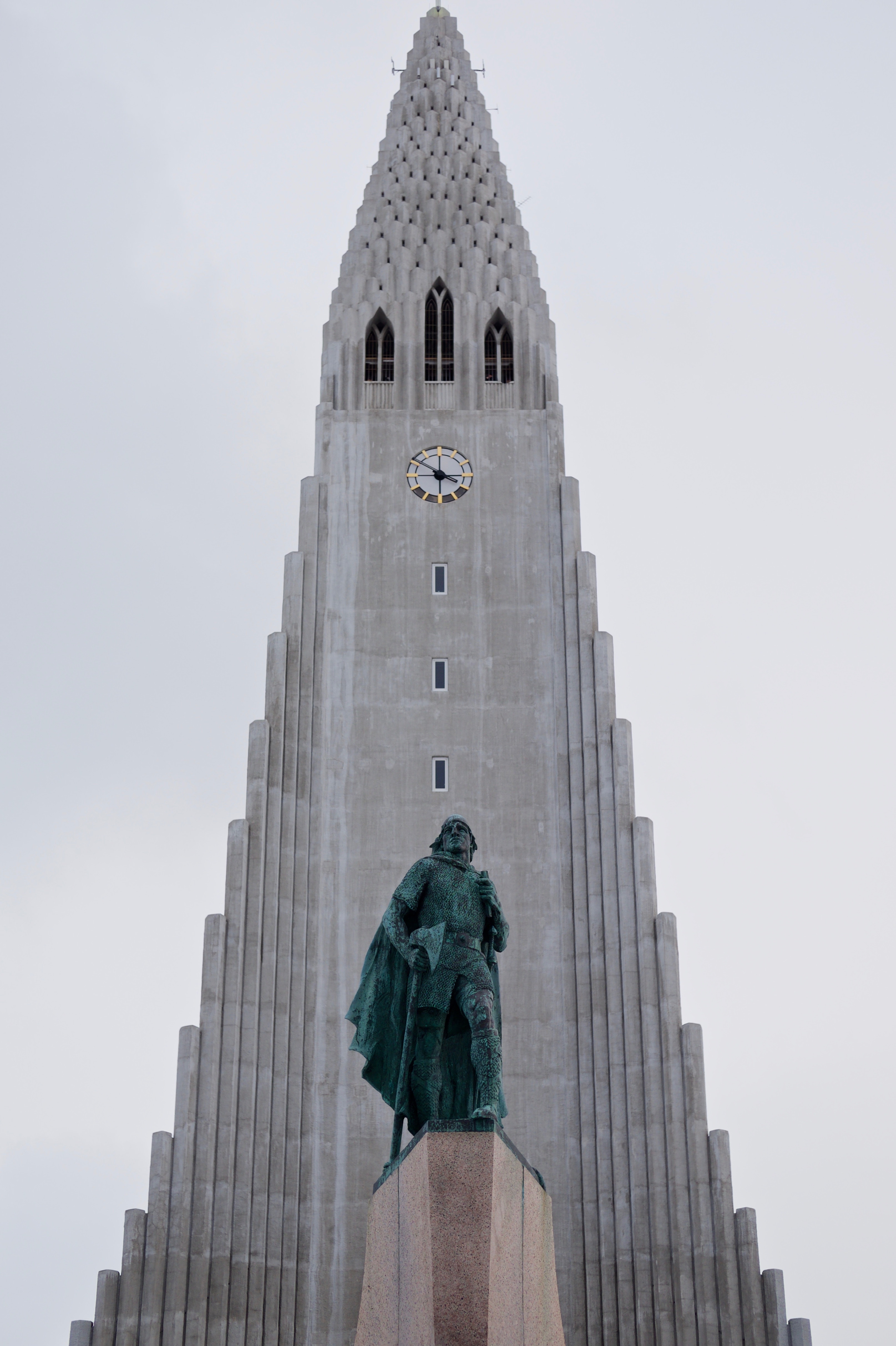
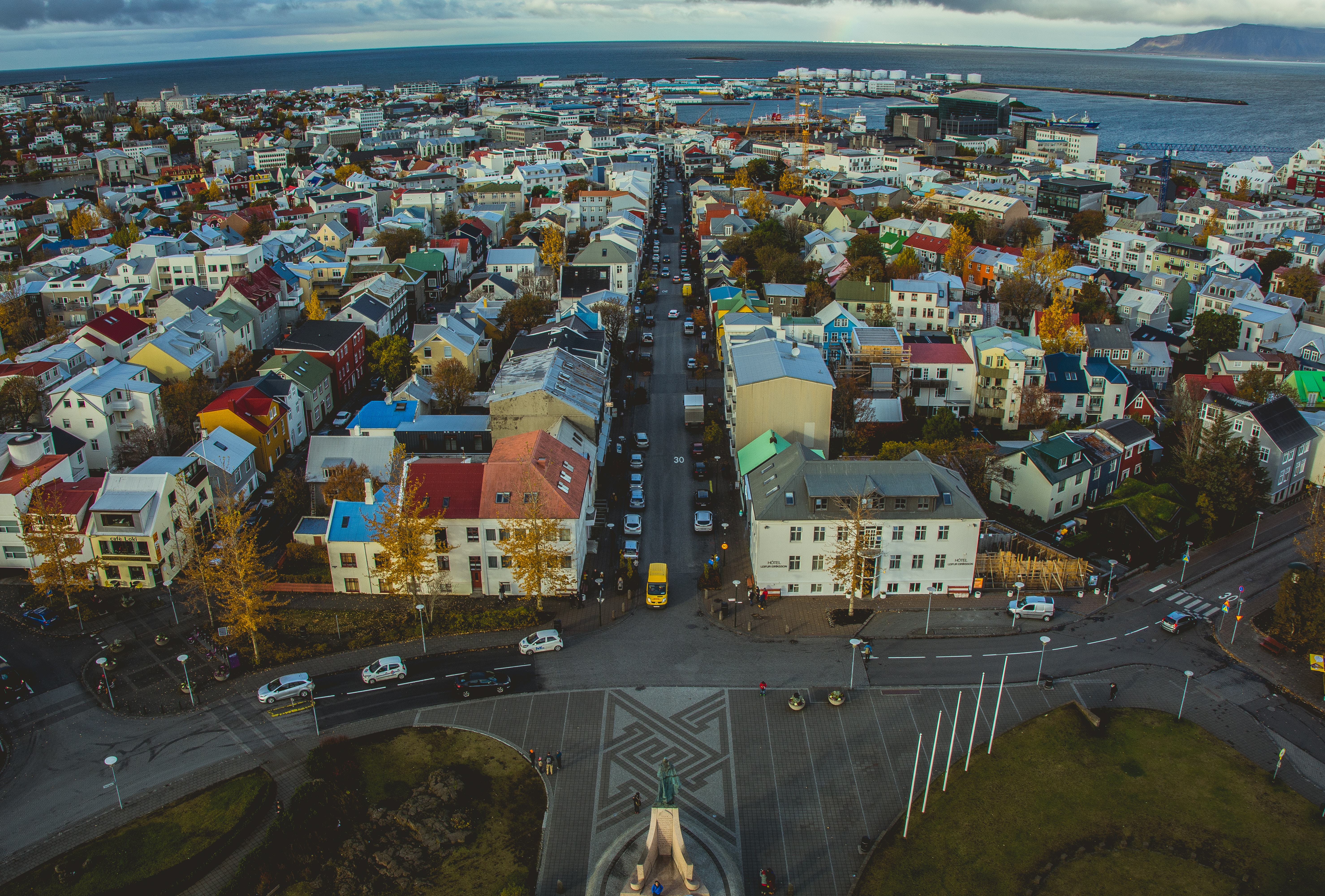
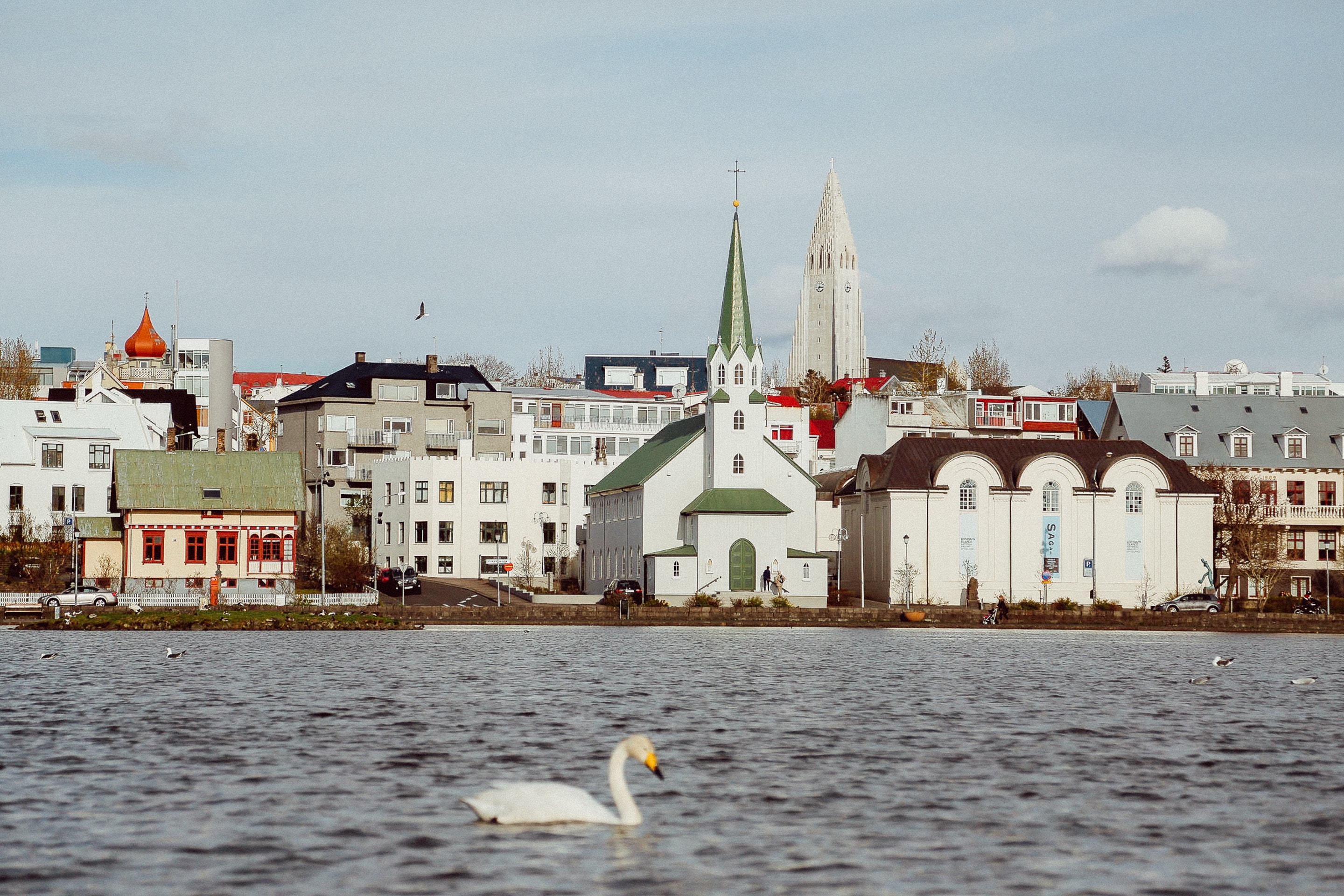
About Reykjavík
Sprawling Reykjavík, the nation's nerve center and government seat, is home to half the island's population. On a bay overlooked by proud Mt. Esja (pronounced eh-shyuh), with its ever-changing hues, Reykjavík presents a colorful sight, its concrete houses painted in light colors and topped by vibrant red, blue, and green roofs. In contrast to the almost treeless countryside, Reykjavík has many tall, native birches, rowans, and willows, as well as imported aspen, pines, and spruces.Reykjavík's name comes from the Icelandic words for smoke, reykur, and bay, vík. In AD 874, Norseman Ingólfur Arnarson saw Iceland rising out of the misty sea and came ashore at a bay eerily shrouded with plumes of steam from nearby hot springs. Today most of the houses in Reykjavík are heated by near-boiling water from the hot springs. Natural heating avoids air pollution; there's no smoke around. You may notice, however, that the hot water brings a slight sulfur smell to the bathroom.Prices are easily on a par with other major European cities. A practical option is to purchase a Reykjavík City Card at the Tourist Information Center or at the Reykjavík Youth Hostel. This card permits unlimited bus usage and admission to any of the city's seven pools, the Family Park and Zoo, and city museums. The cards are valid for one (ISK 3,300), two (ISK 4,400), or three days (ISK 4,900), and they pay for themselves after three or four uses a day. Even lacking the City Card, paying admission (ISK 500, or ISK 250 for seniors and people with disabilities) to one of the city art museums (Hafnarhús, Kjarvalsstaðir, or Ásmundarsafn) gets you free same-day admission to the other two.
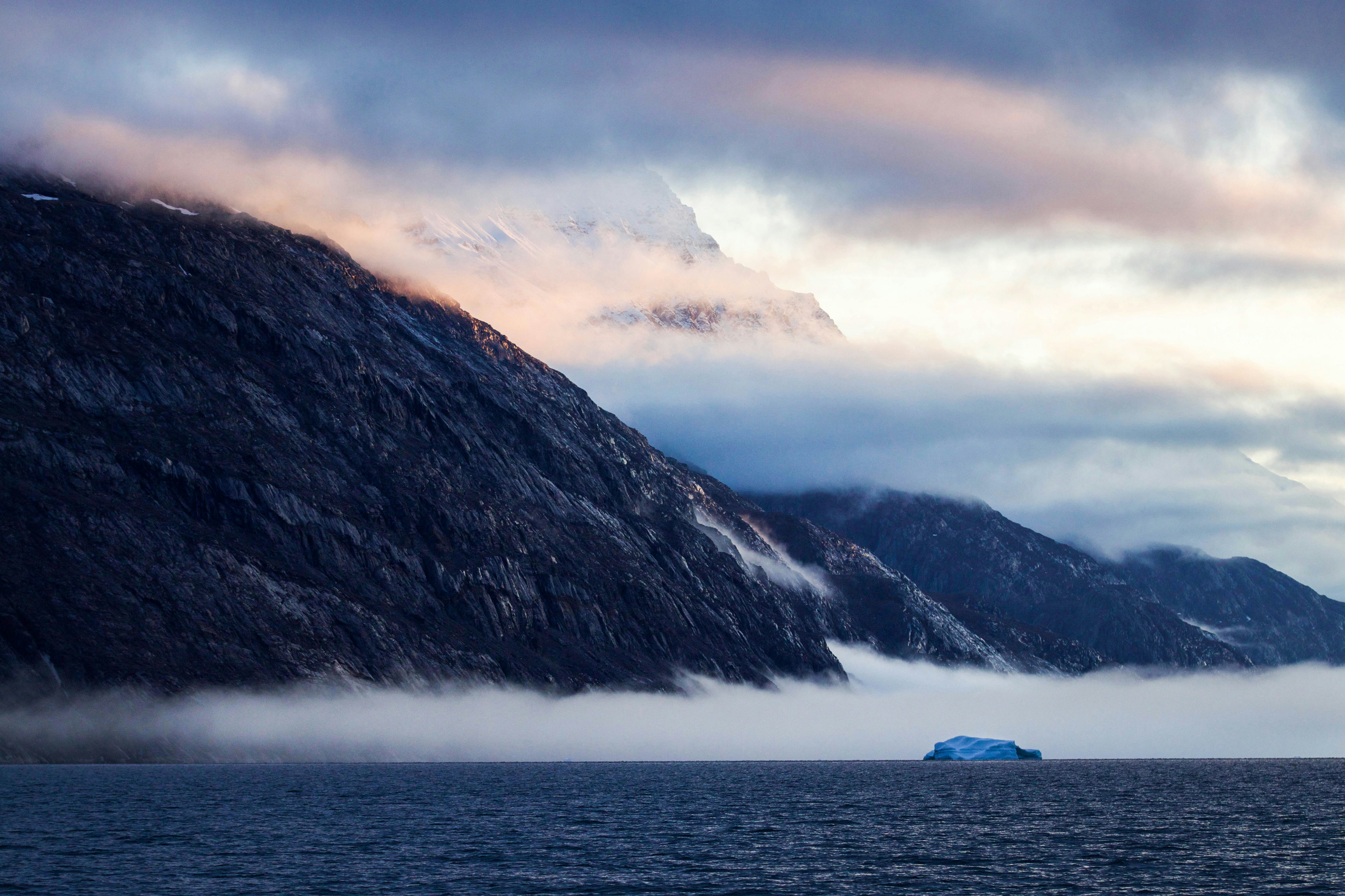
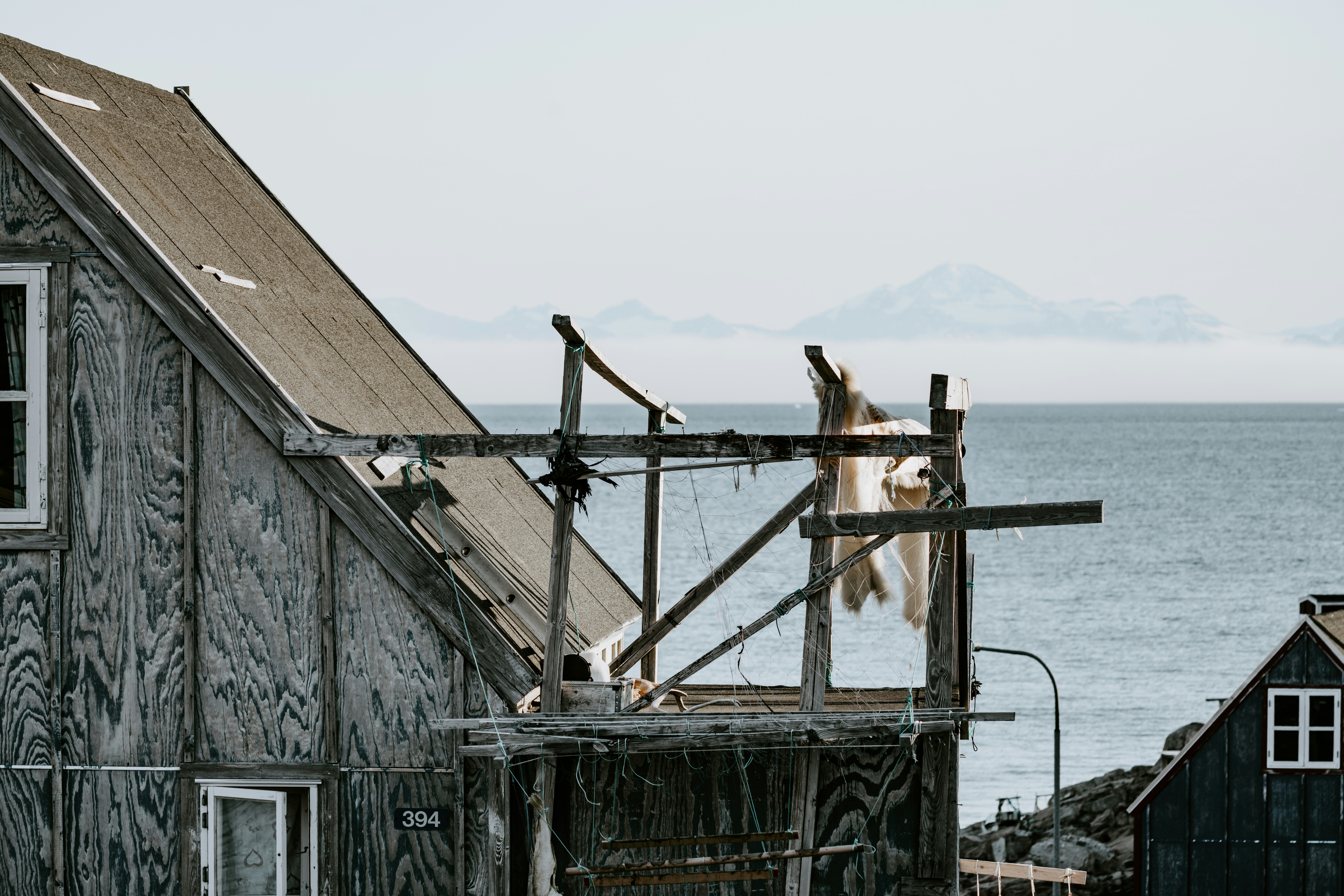
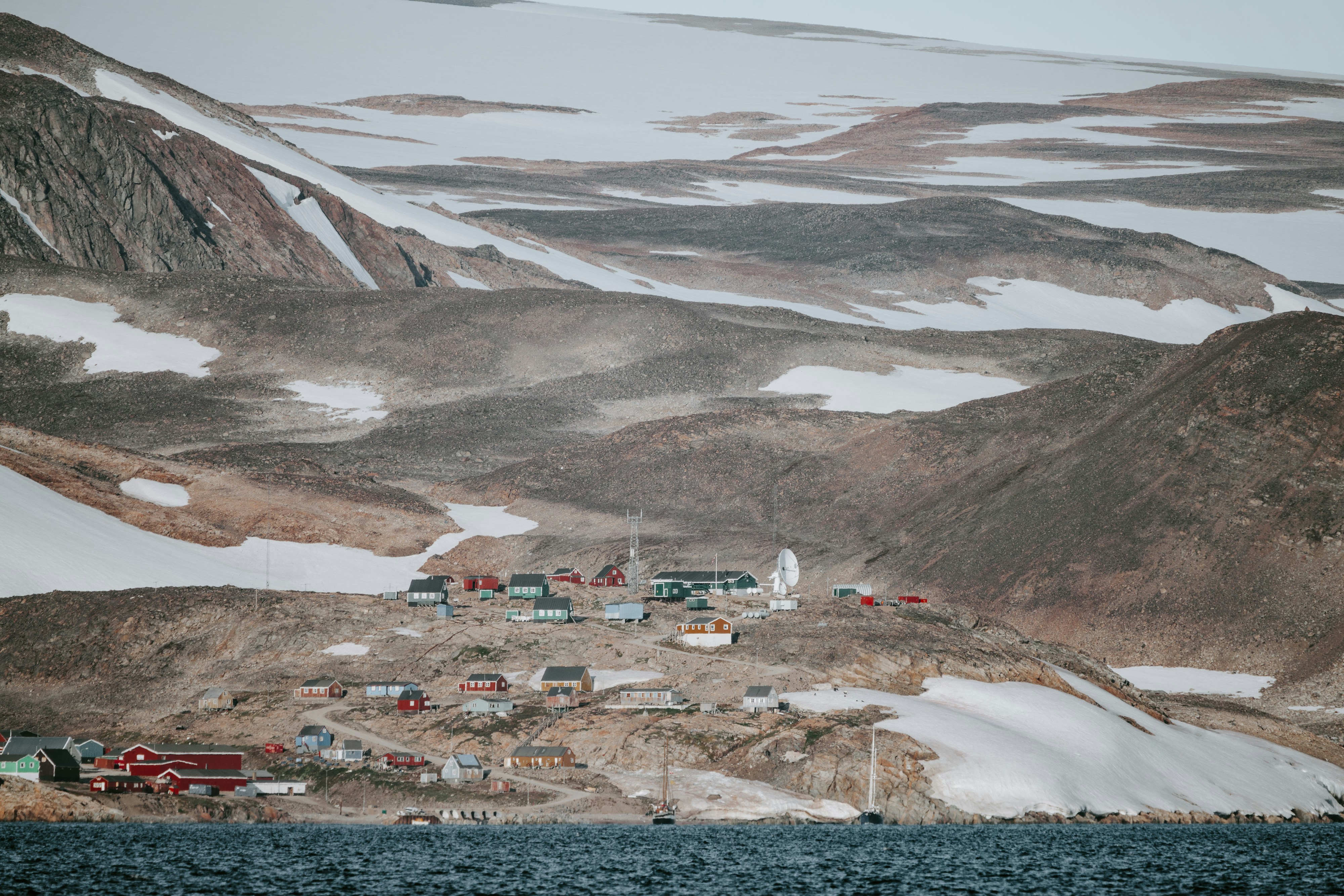
About Ittoqqortoormiit (ex Scoresbysund)
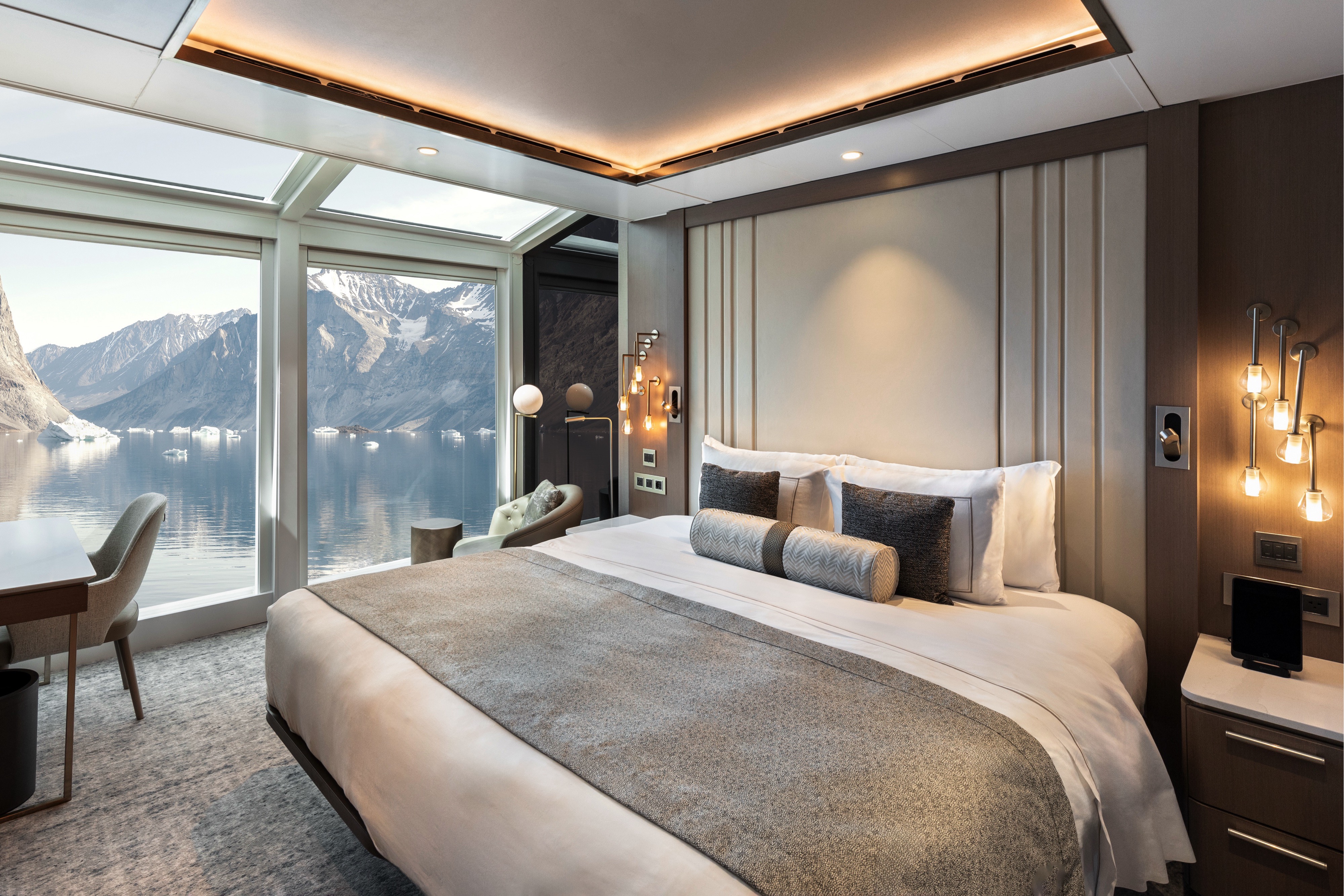
Scoresbysund is the ultimate fjord system; likely the longest, largest and deepest of any in the world. The massive fjord is tucked into the eastern coast of Greenland and on the icy western edges of the Greenland Sea. Scoresbysund’s scale deserves several days to explore, especially while plying the waters between castle-sized icebergs as they gently drift under the persuasion of the Arctic waters in the mighty fjord. Scattered in the remote bays and smaller fjords are places to discover old Inuit settlements, slowly growing over with Arctic willow and dwarf birch. The lower slopes of many mountains are draped in the herbs and grasses favoured by muskox, Arctic fox, lemmings, Ptarmigan, Barnacle Geese, and Snowy Owls. Tundra walks give impressive views of landscape, flora and fauna. Not to be neglected, the waters of Scoresbysund warrant a vigilant eye for sightings of whales, seals, narwhals, beluga whales and walrus.
About Ittoqqortoormiit (ex Scoresbysund)
Scoresbysund is the ultimate fjord system; likely the longest, largest and deepest of any in the world. The massive fjord is tucked into the eastern coast of Greenland and on the icy western edges of the Greenland Sea. Scoresbysund’s scale deserves several days to explore, especially while plying the waters between castle-sized icebergs as they gently drift under the persuasion of the Arctic waters in the mighty fjord. Scattered in the remote bays and smaller fjords are places to discover old Inuit settlements, slowly growing over with Arctic willow and dwarf birch. The lower slopes of many mountains are draped in the herbs and grasses favoured by muskox, Arctic fox, lemmings, Ptarmigan, Barnacle Geese, and Snowy Owls. Tundra walks give impressive views of landscape, flora and fauna. Not to be neglected, the waters of Scoresbysund warrant a vigilant eye for sightings of whales, seals, narwhals, beluga whales and walrus.
About Kaiser Franz Joseph Fjord
About Kaiser Franz Joseph Fjord
About Kaiser Franz Joseph Fjord
About Kaiser Franz Joseph Fjord
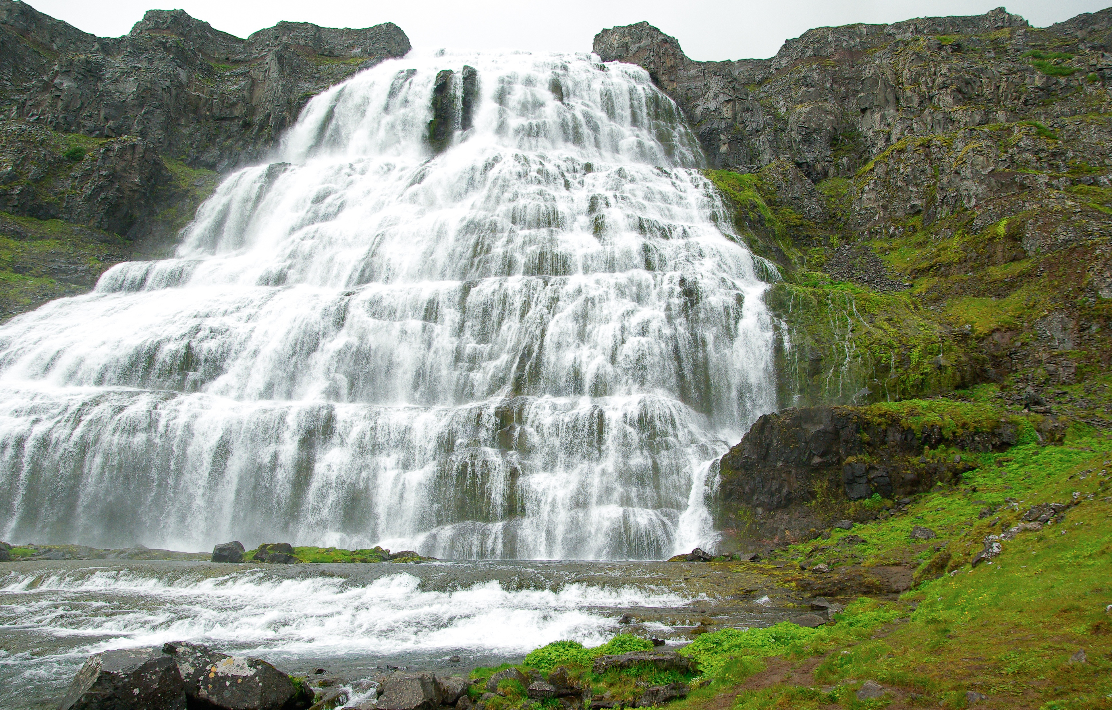
About Dynjandi Waterfalls
Iceland is well-known for its spectacular waterfalls. The iconic Dynjandi waterfall, located in the Westfjords region, is regarded as one of Iceland’s most impressive and majestic waterfalls. At the top, the cascading water is roughly 100 feet wide and tumbles down about 330 feet into the fjord. Its name Dynjandi means, “the thundering one” and its vast size, enormous sound, and sheer force is overwhelming. It has also been nicknamed, ‘The Bridal Veil’ because of the way the water sprays and spreads over the rocks.
About Reykjavík
Sprawling Reykjavík, the nation's nerve center and government seat, is home to half the island's population. On a bay overlooked by proud Mt. Esja (pronounced eh-shyuh), with its ever-changing hues, Reykjavík presents a colorful sight, its concrete houses painted in light colors and topped by vibrant red, blue, and green roofs. In contrast to the almost treeless countryside, Reykjavík has many tall, native birches, rowans, and willows, as well as imported aspen, pines, and spruces.Reykjavík's name comes from the Icelandic words for smoke, reykur, and bay, vík. In AD 874, Norseman Ingólfur Arnarson saw Iceland rising out of the misty sea and came ashore at a bay eerily shrouded with plumes of steam from nearby hot springs. Today most of the houses in Reykjavík are heated by near-boiling water from the hot springs. Natural heating avoids air pollution; there's no smoke around. You may notice, however, that the hot water brings a slight sulfur smell to the bathroom.Prices are easily on a par with other major European cities. A practical option is to purchase a Reykjavík City Card at the Tourist Information Center or at the Reykjavík Youth Hostel. This card permits unlimited bus usage and admission to any of the city's seven pools, the Family Park and Zoo, and city museums. The cards are valid for one (ISK 3,300), two (ISK 4,400), or three days (ISK 4,900), and they pay for themselves after three or four uses a day. Even lacking the City Card, paying admission (ISK 500, or ISK 250 for seniors and people with disabilities) to one of the city art museums (Hafnarhús, Kjarvalsstaðir, or Ásmundarsafn) gets you free same-day admission to the other two.
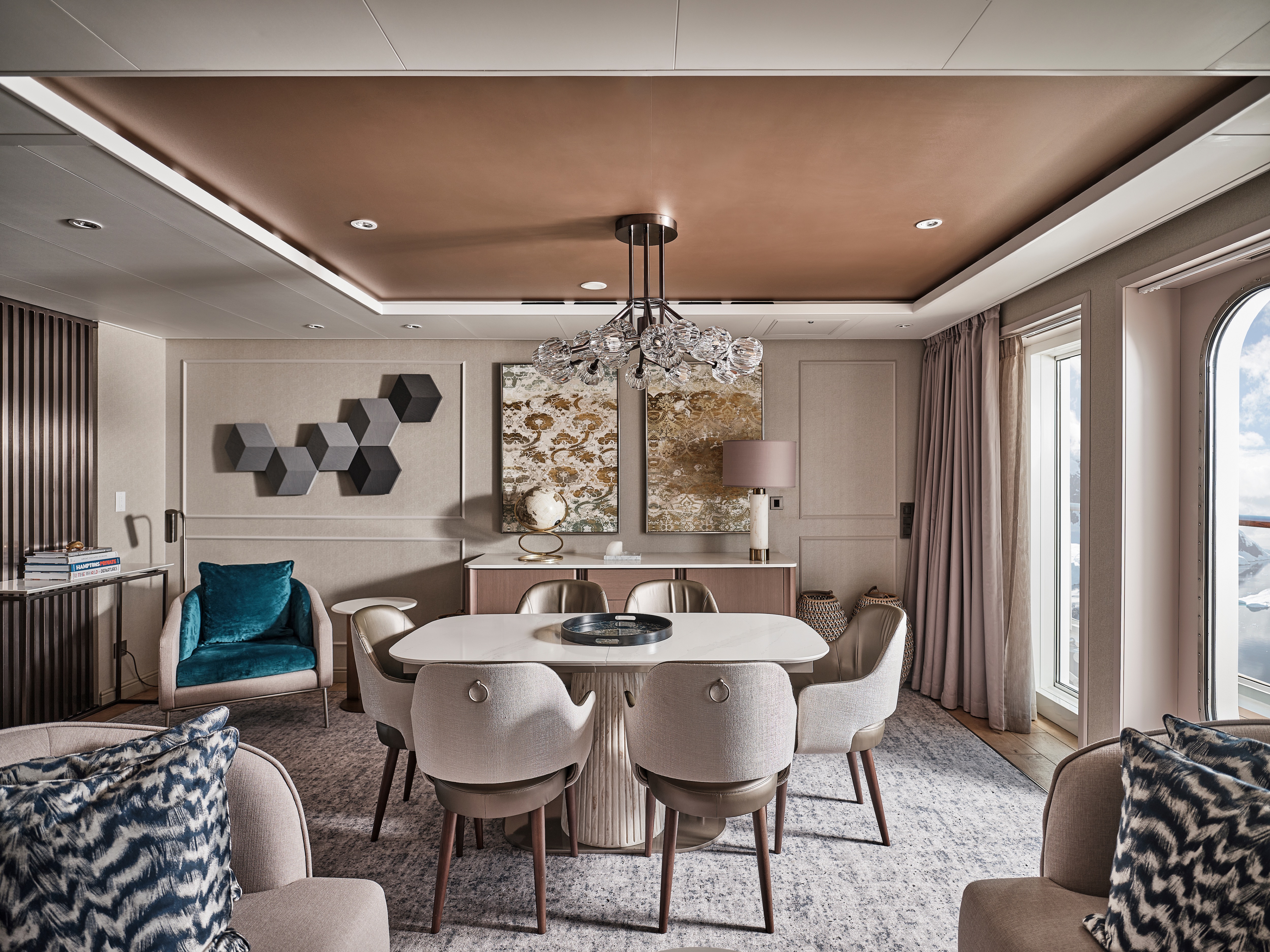
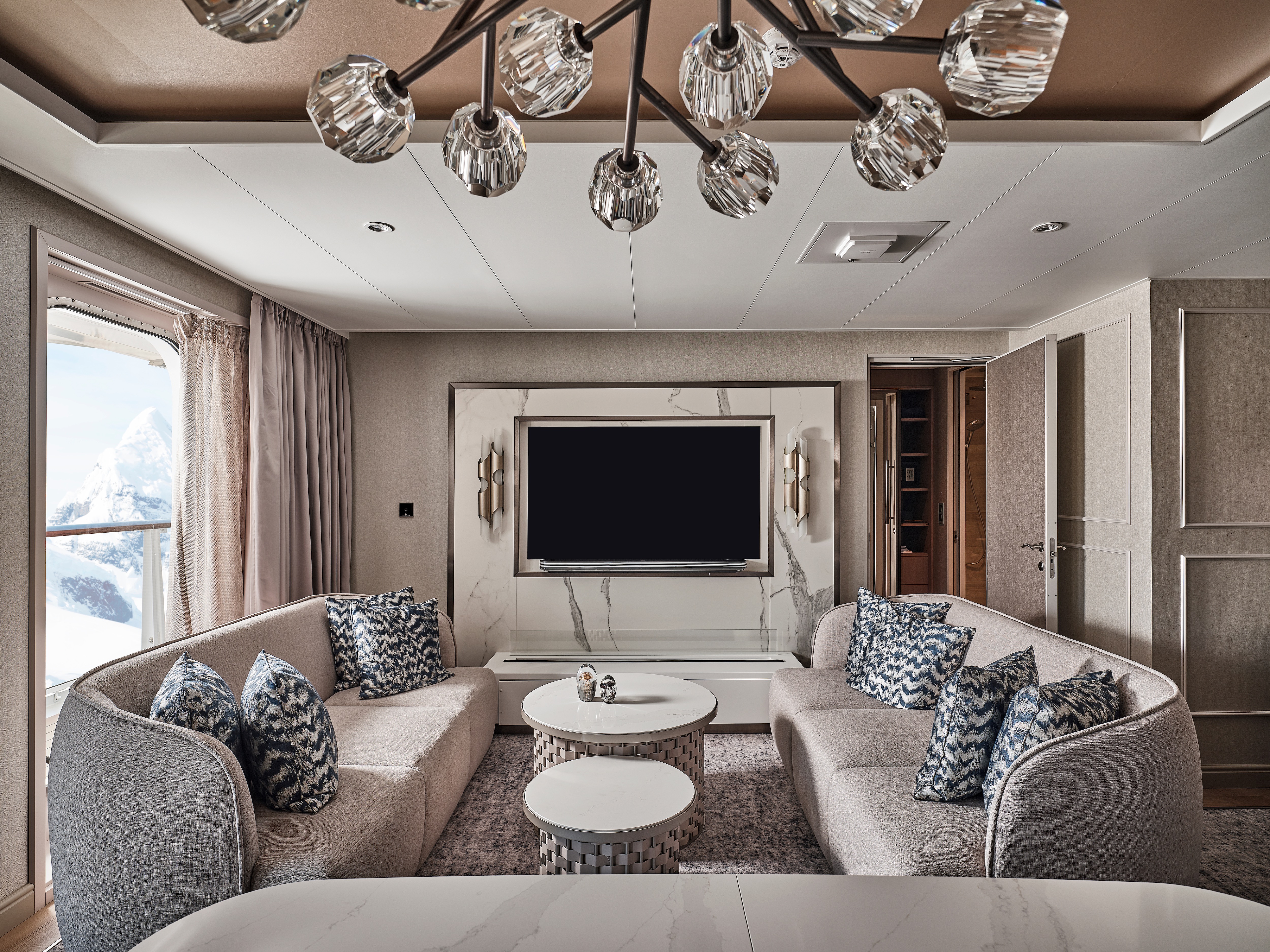
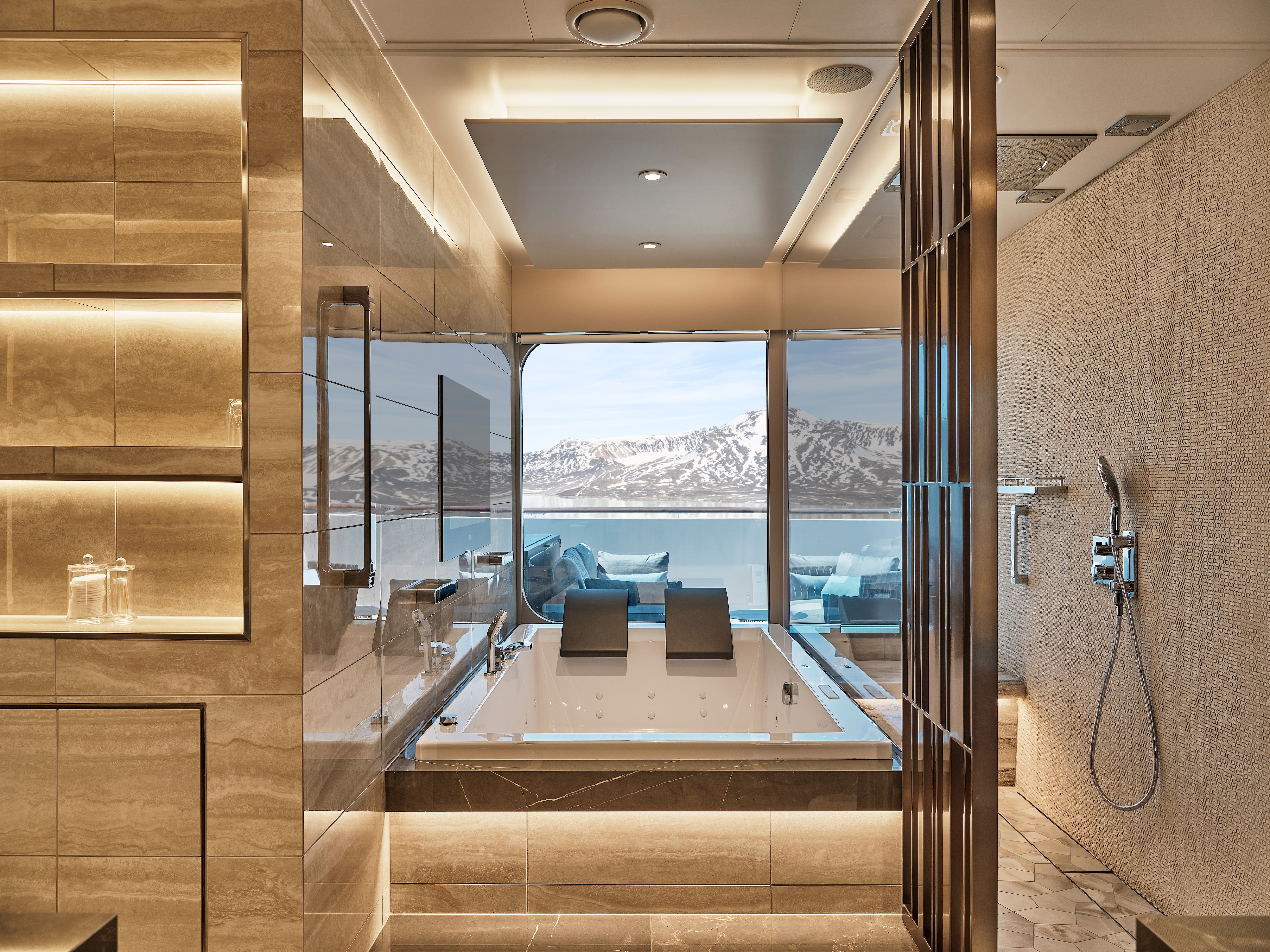
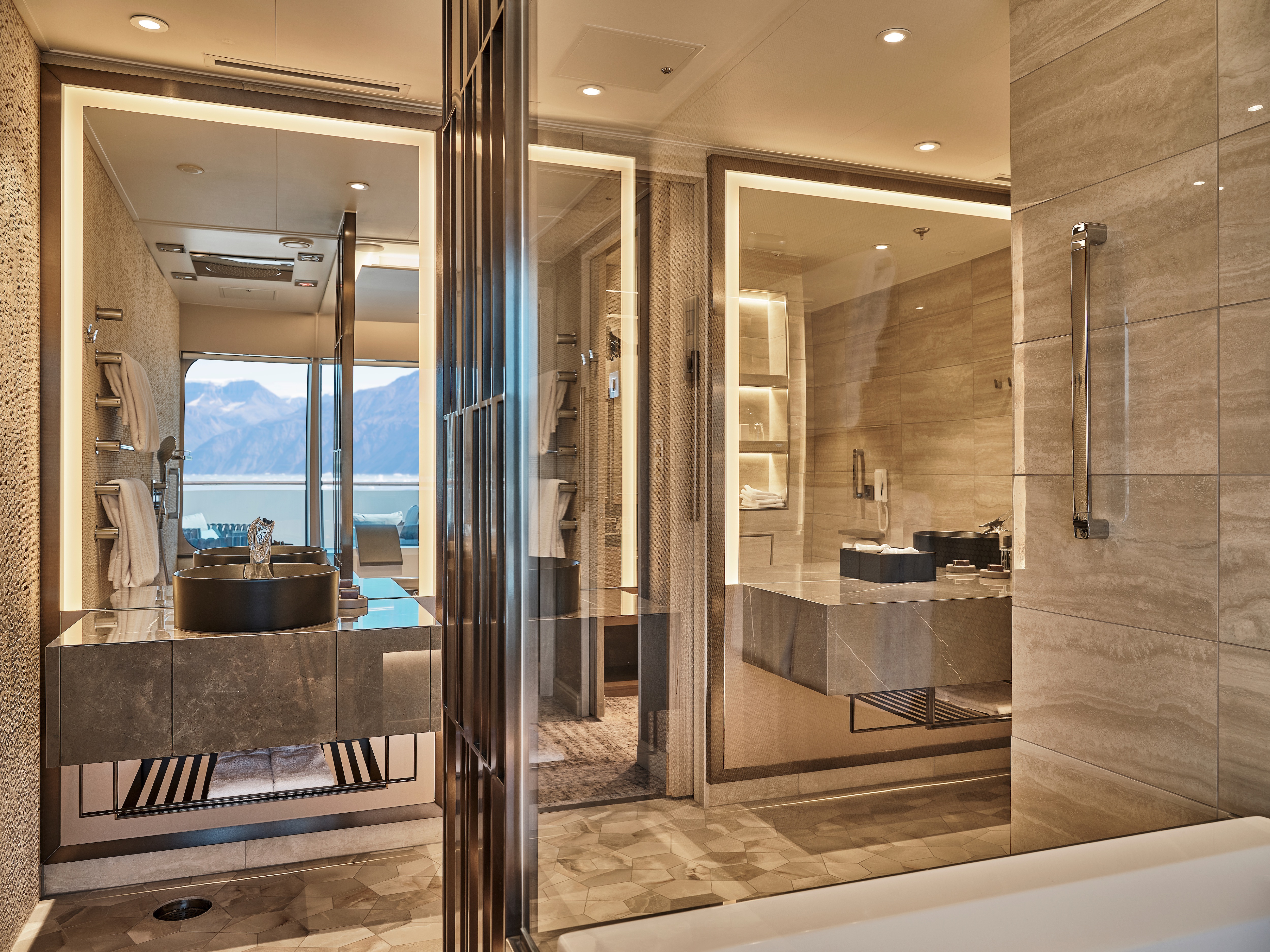
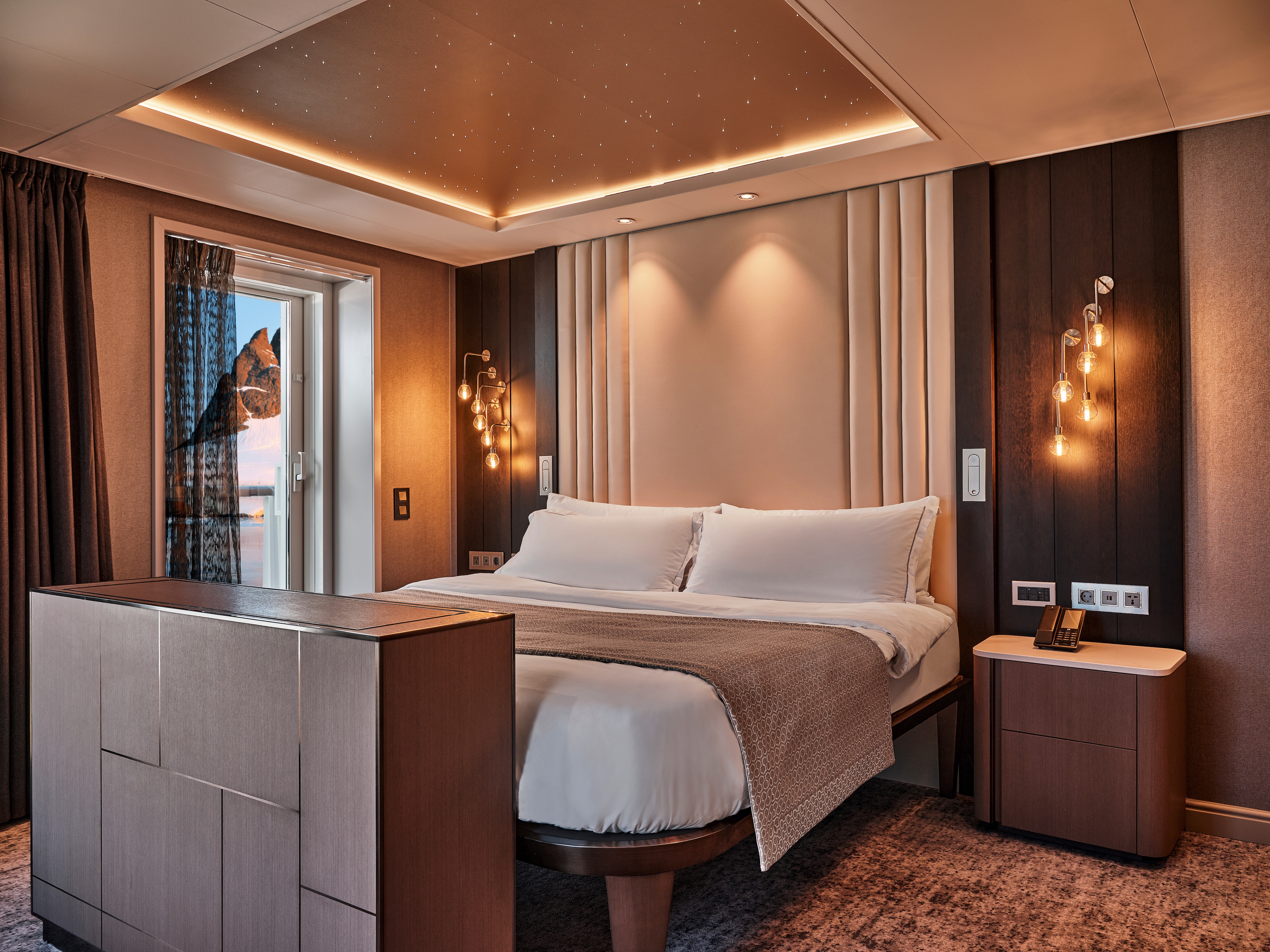
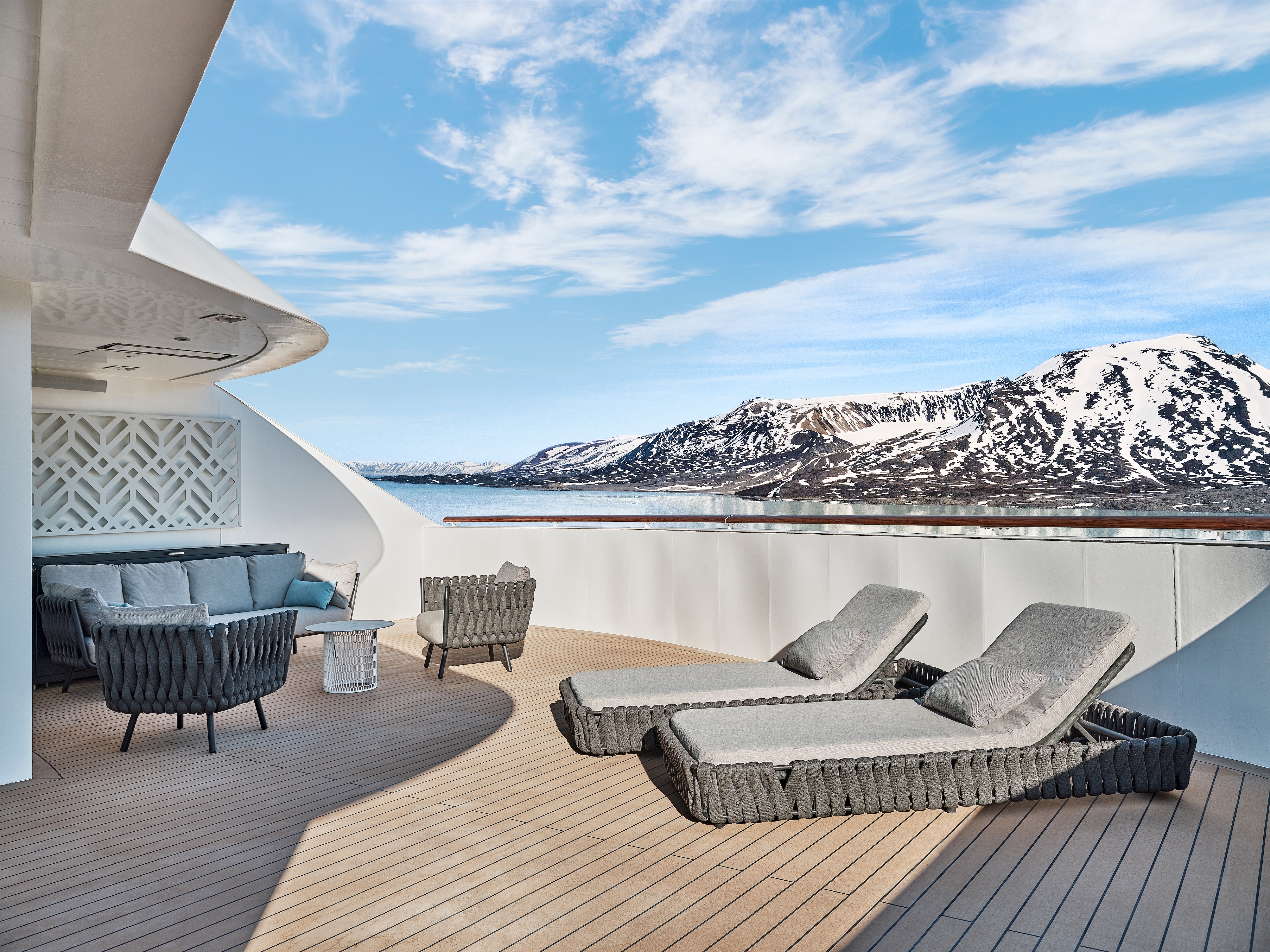
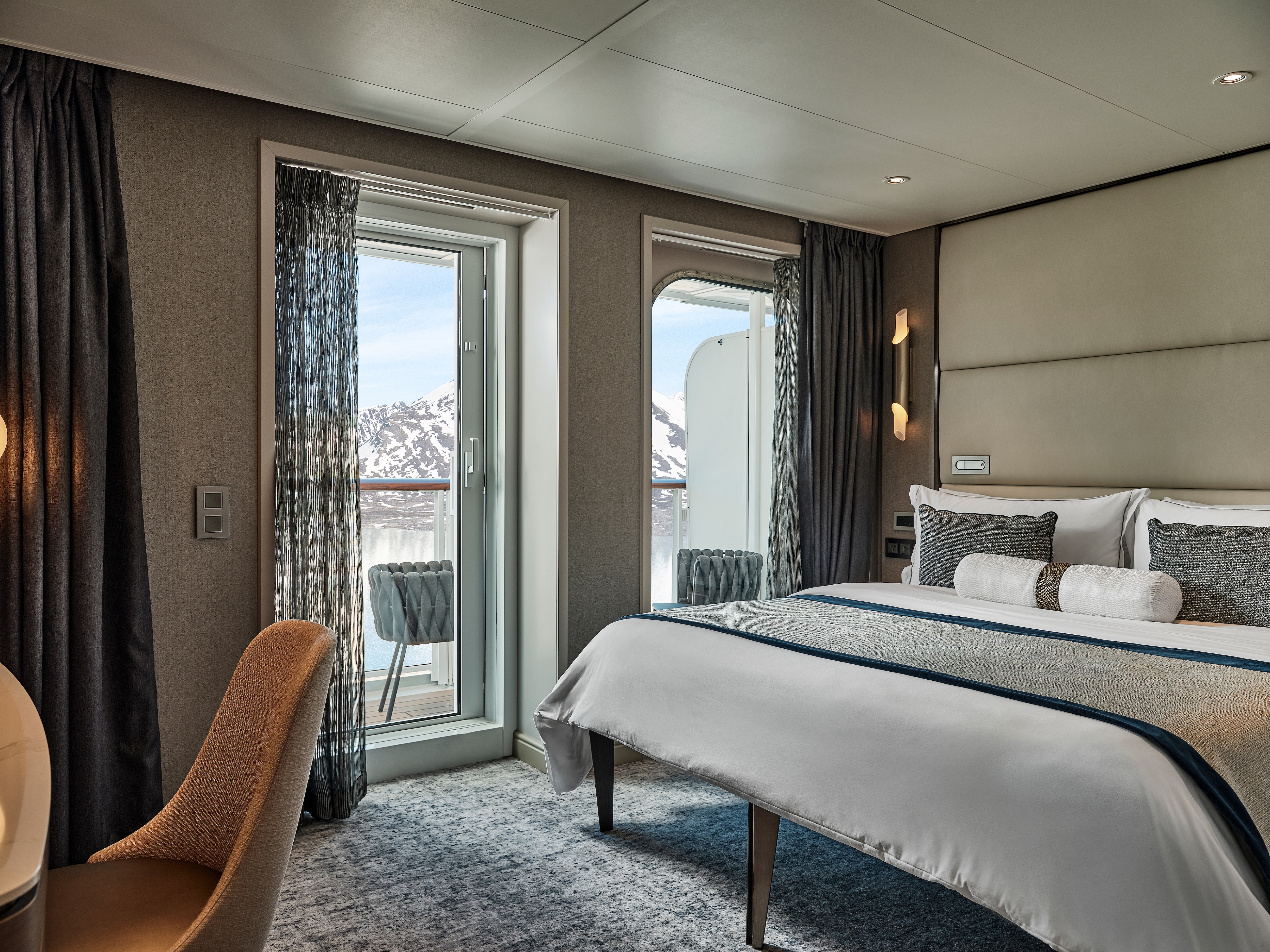
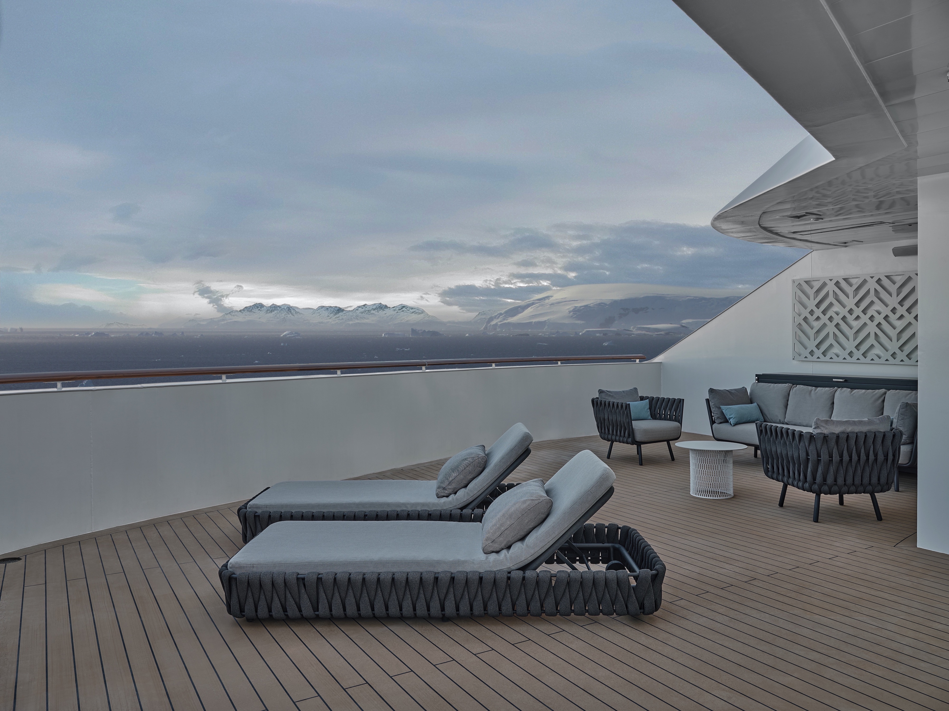
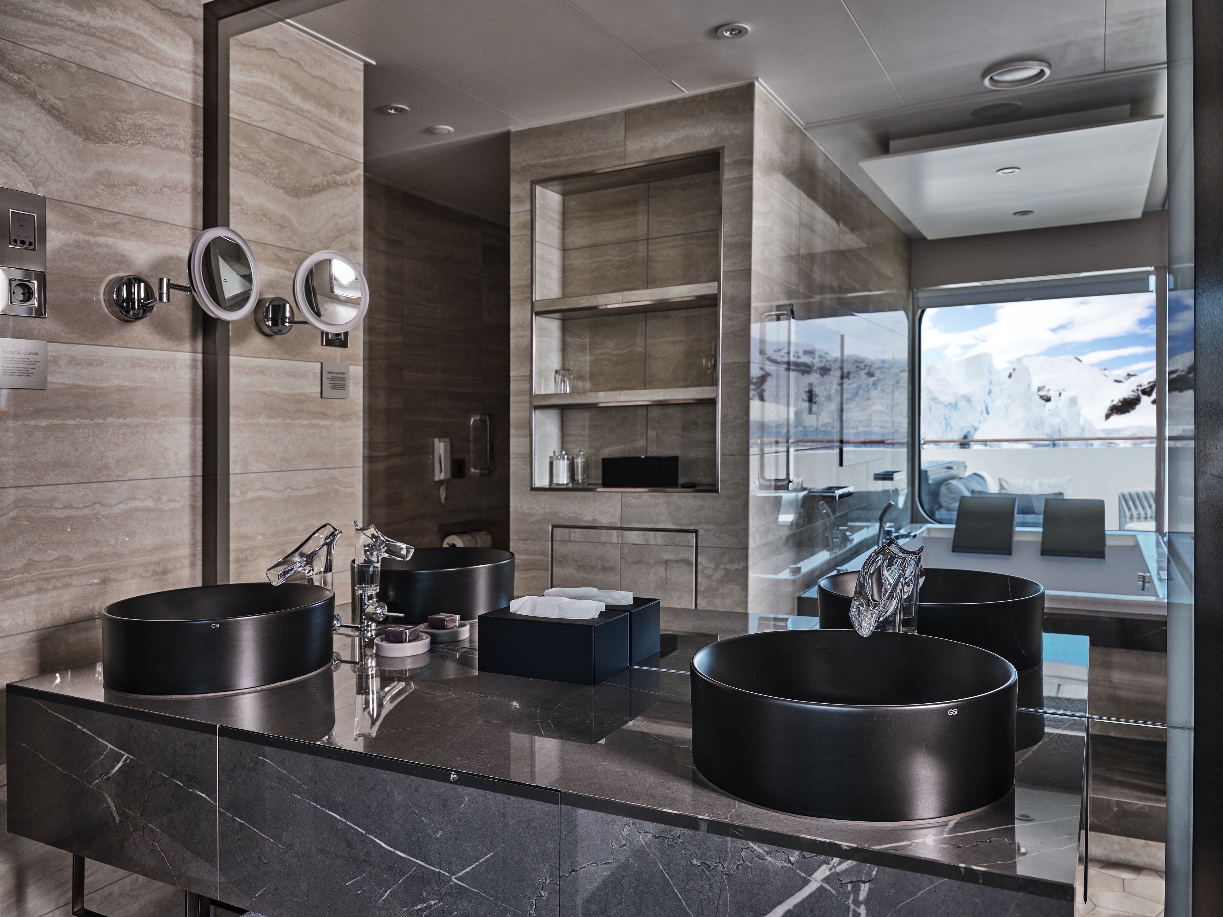
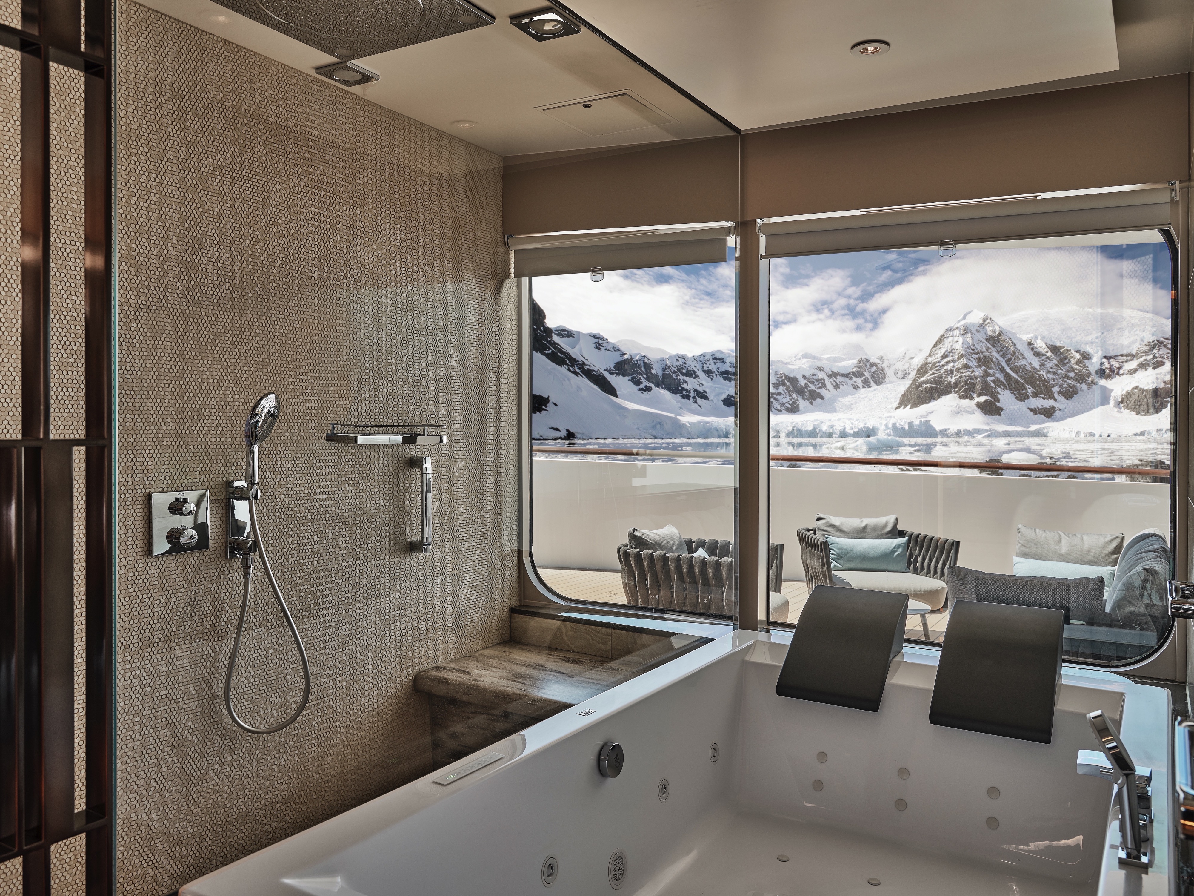
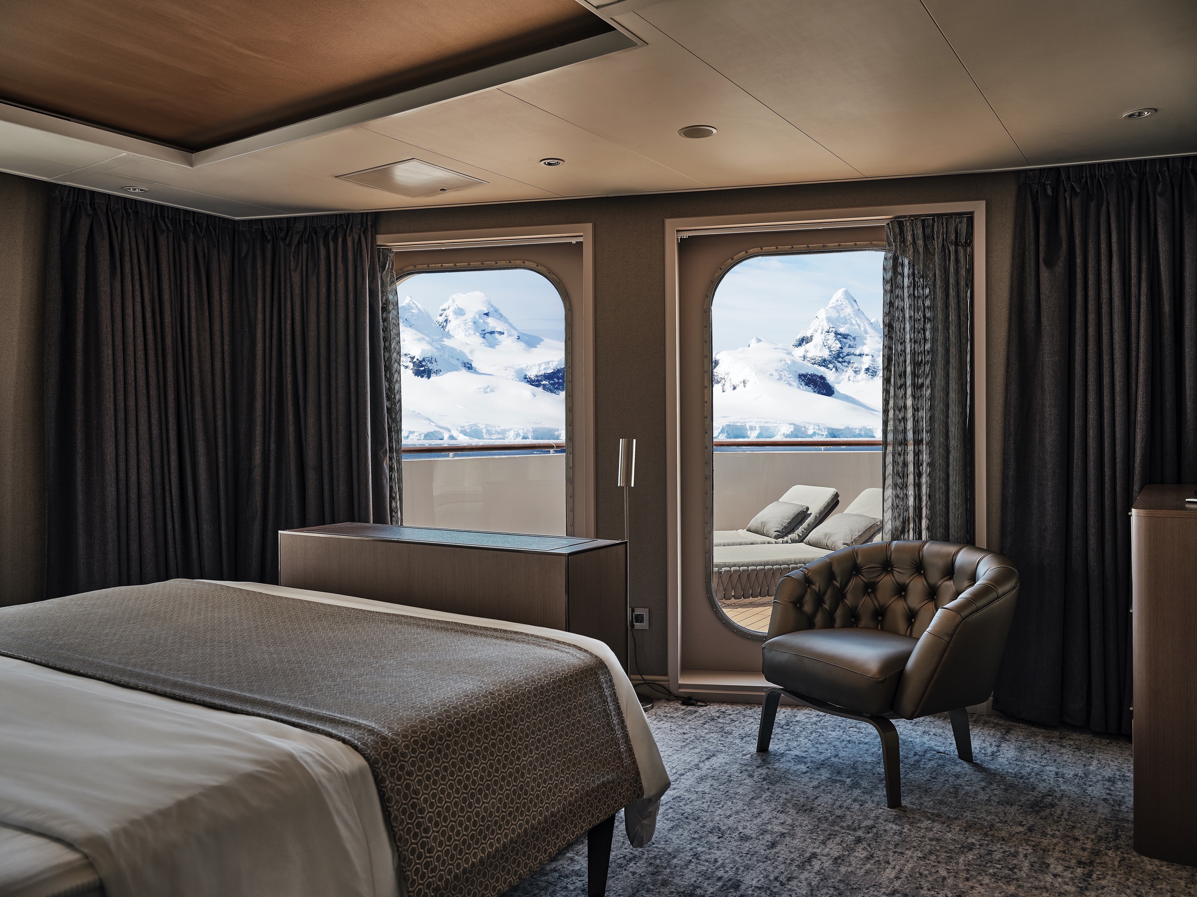
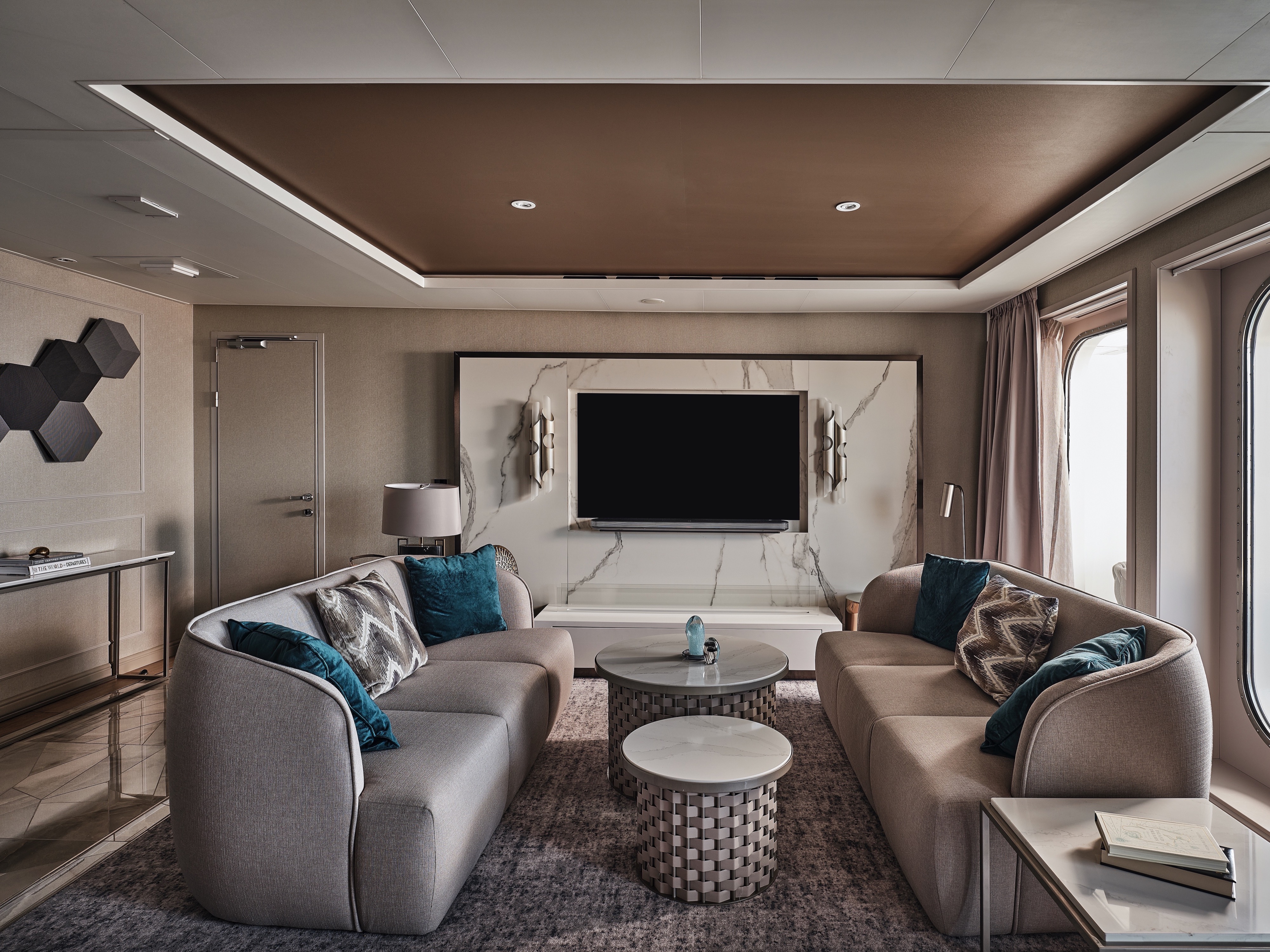
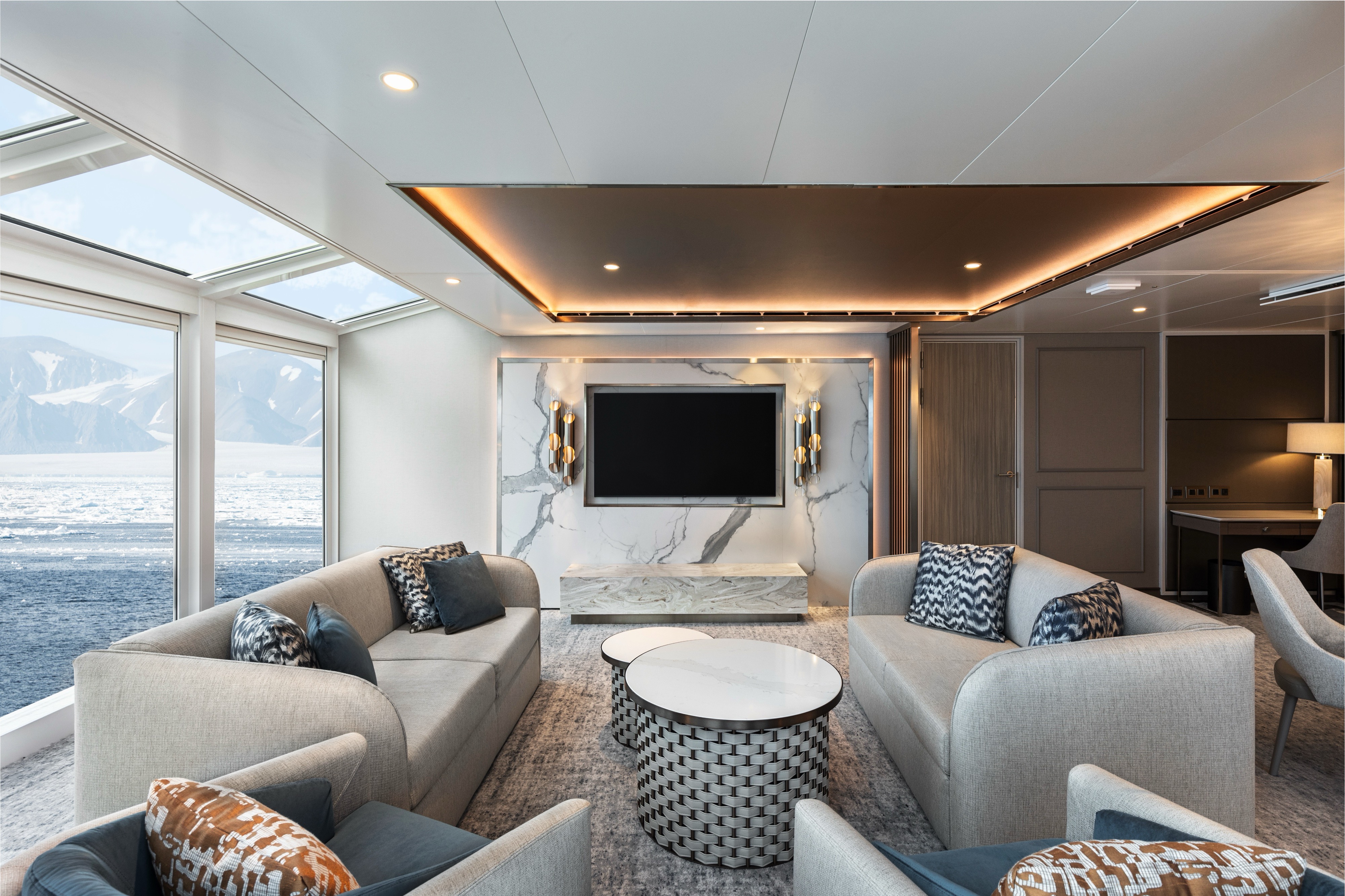
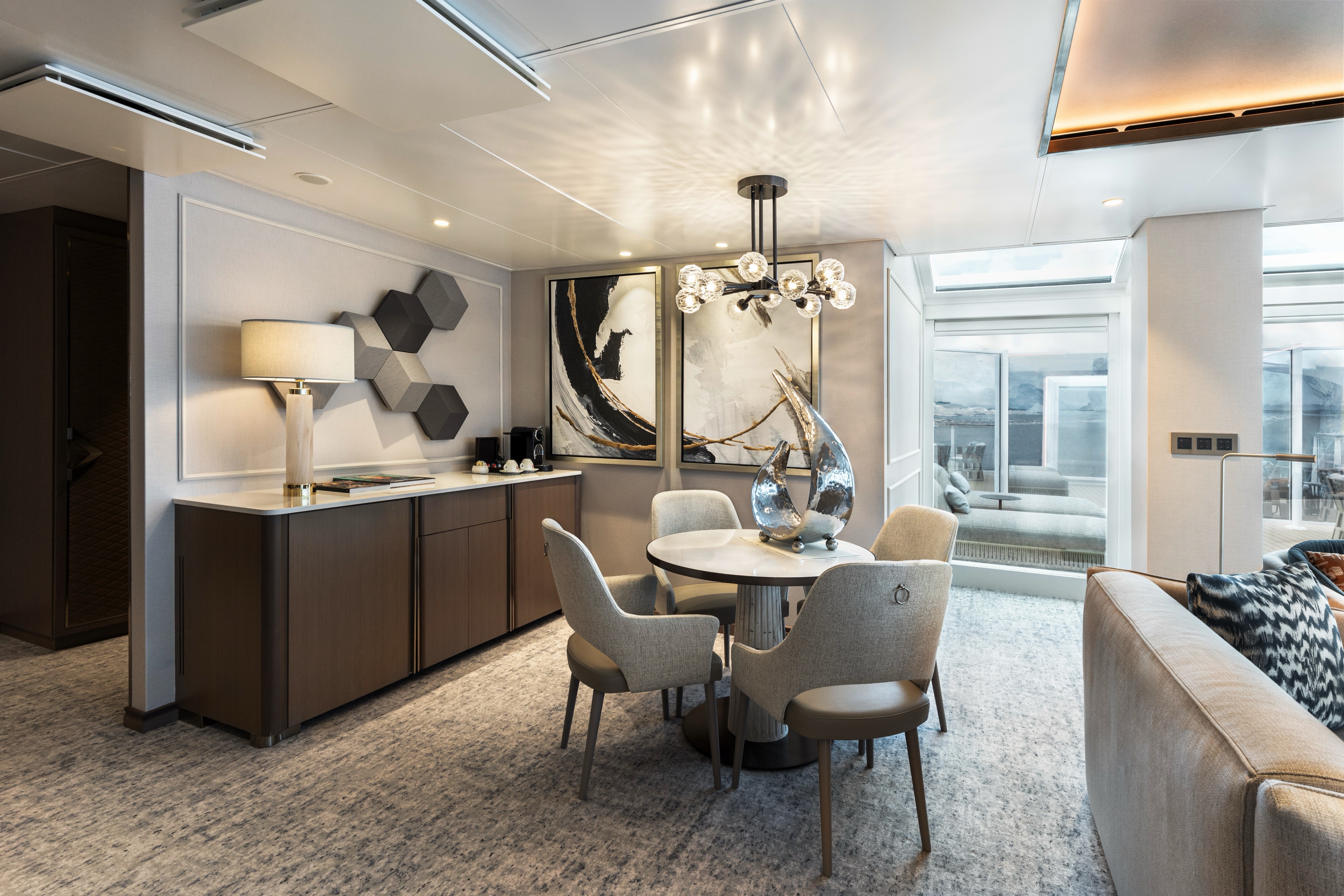
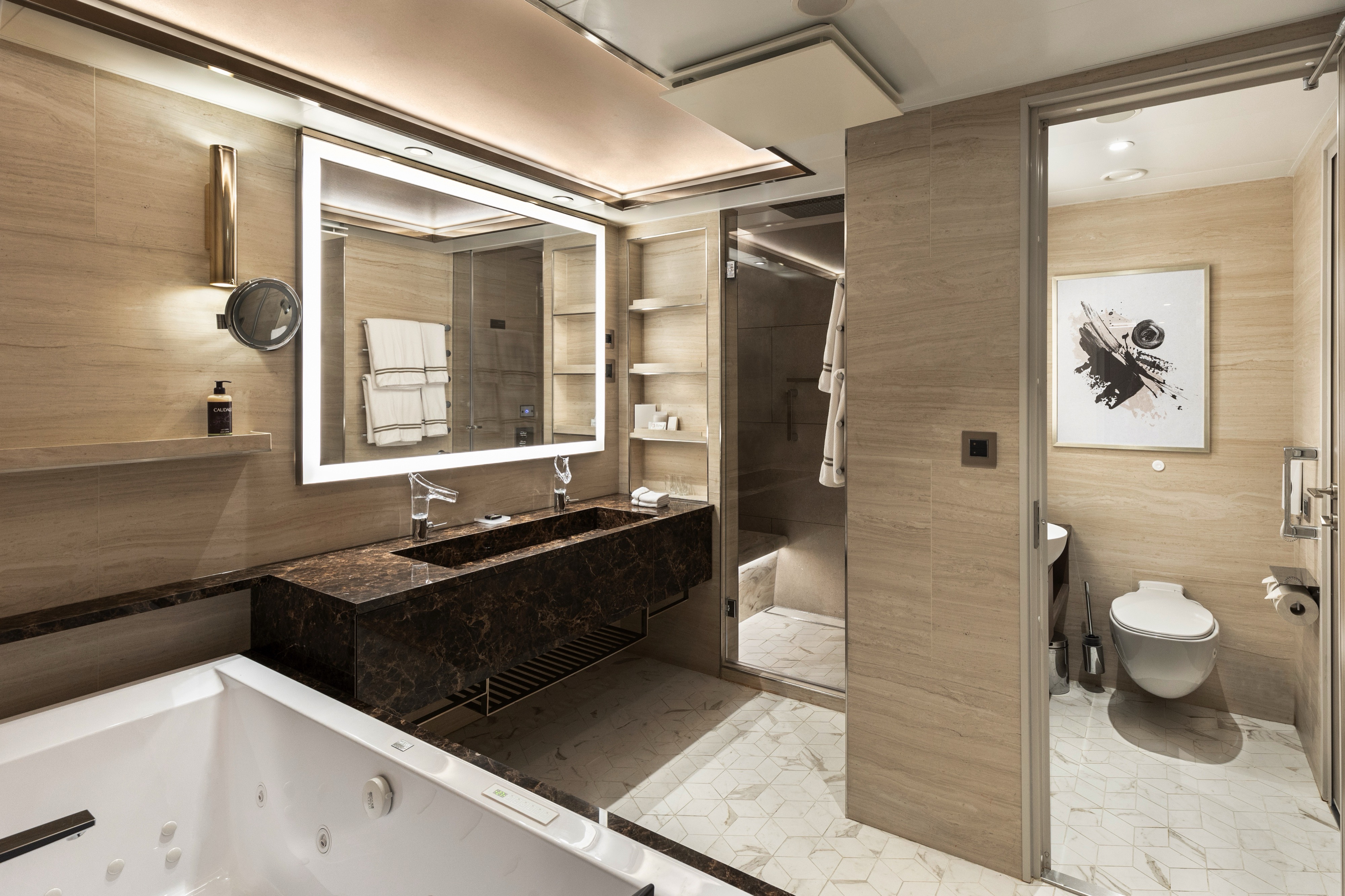
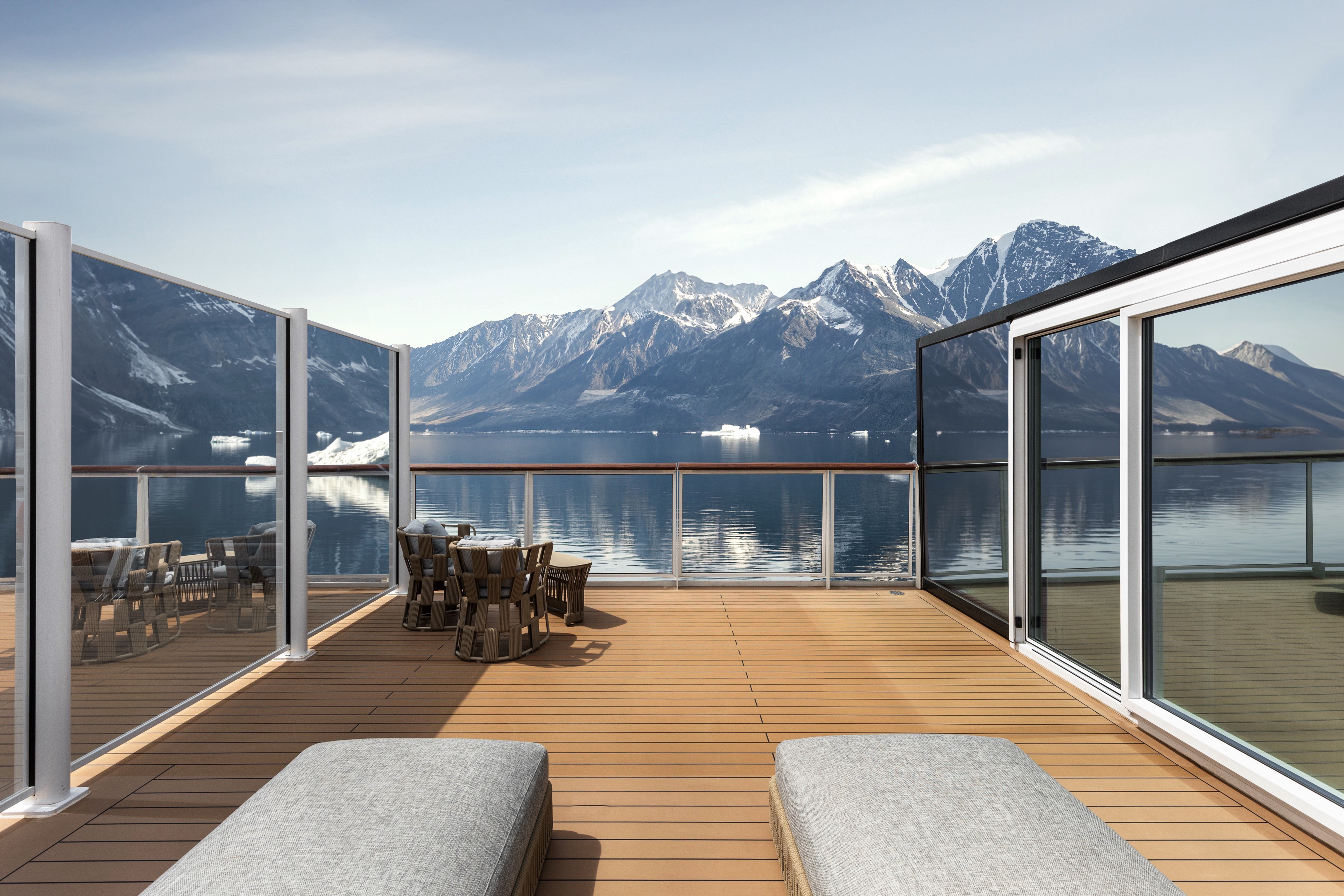
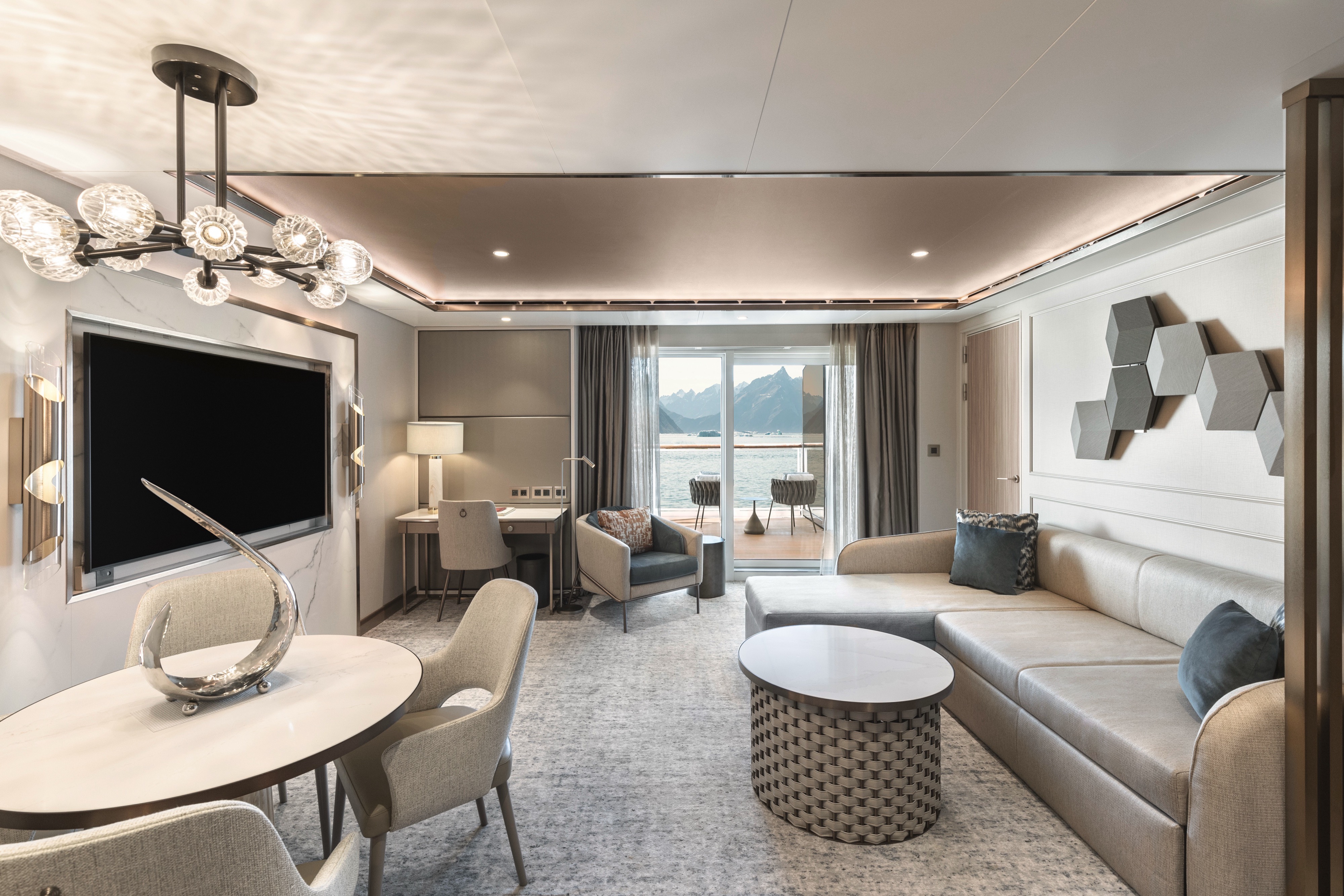
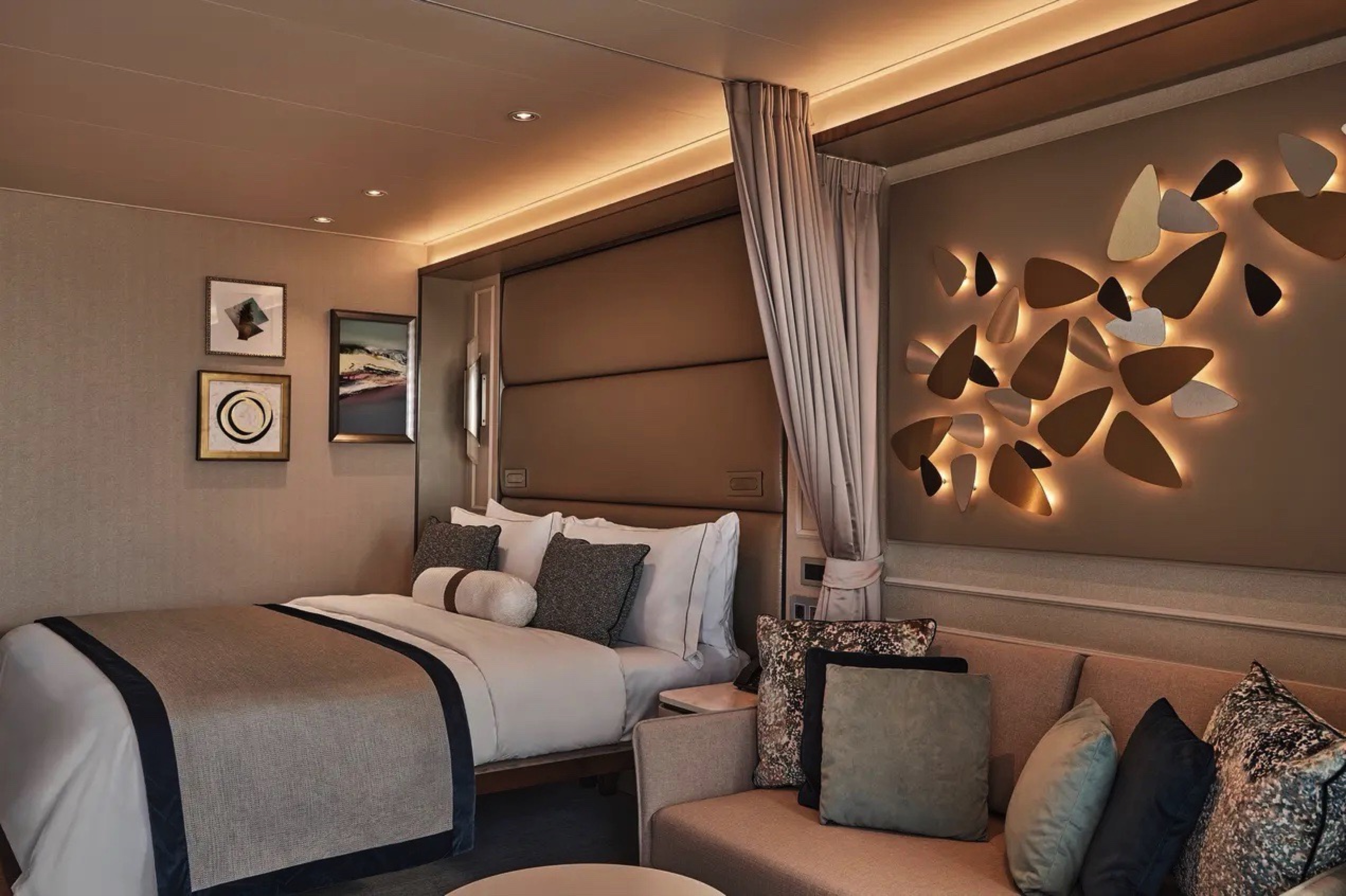
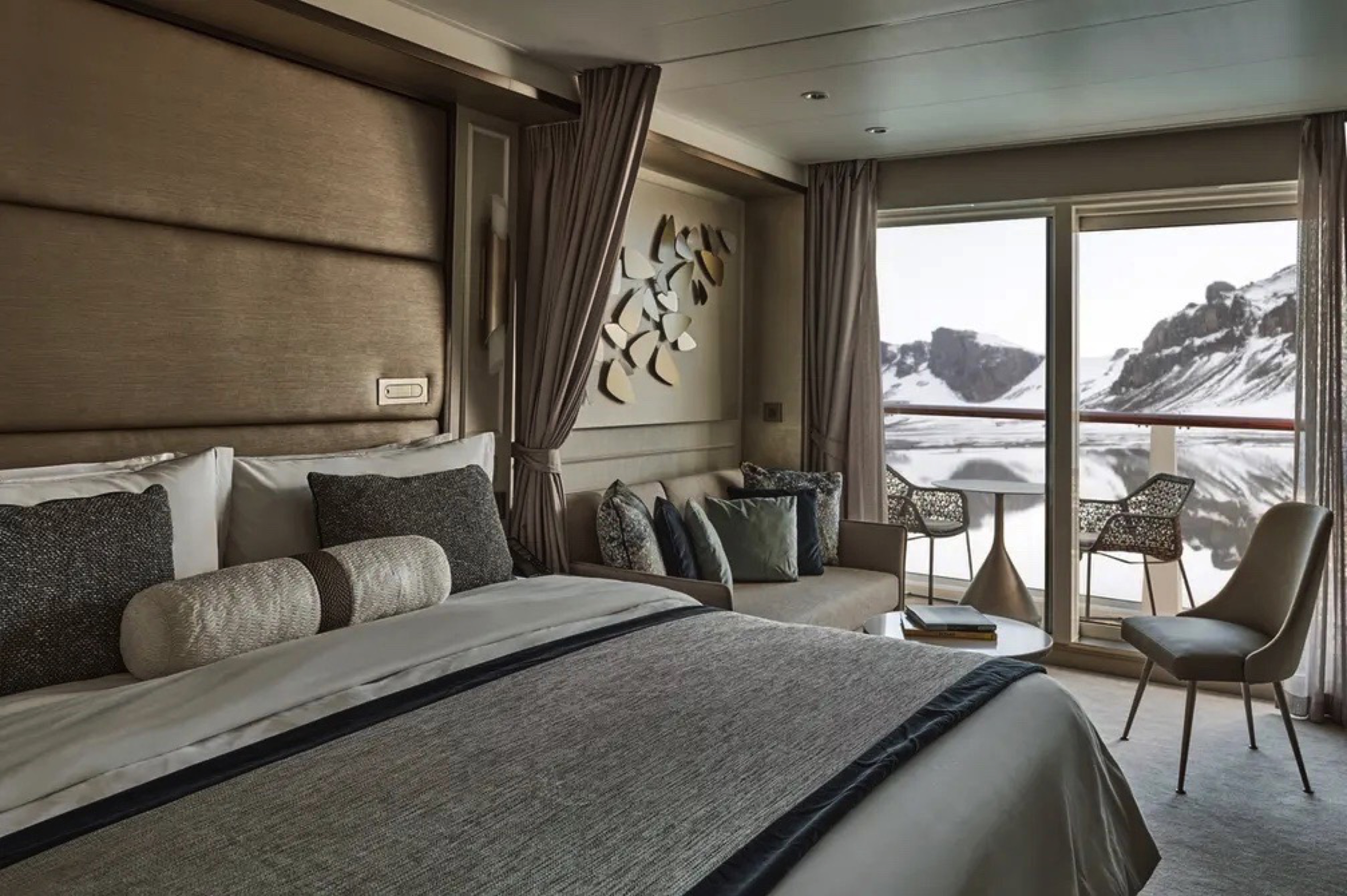
Supremely spacious and superbly located, the Owner’s Suite is the most luxurious suite on board. Located in the premium bow position on deck 7, the Owner’s Suite offers amazing destination immersion, thanks its enormous surrounding balcony and incredible views from all indoor areas. The large living room, separate dining area, and well-stocked bar are perfect for sharing a moment with like-minded travelers while the luxurious and well-appointed bedrooms ensure supreme comfort any time of the day or night.
One bedroom: 173.5 sq m (69 sq m)
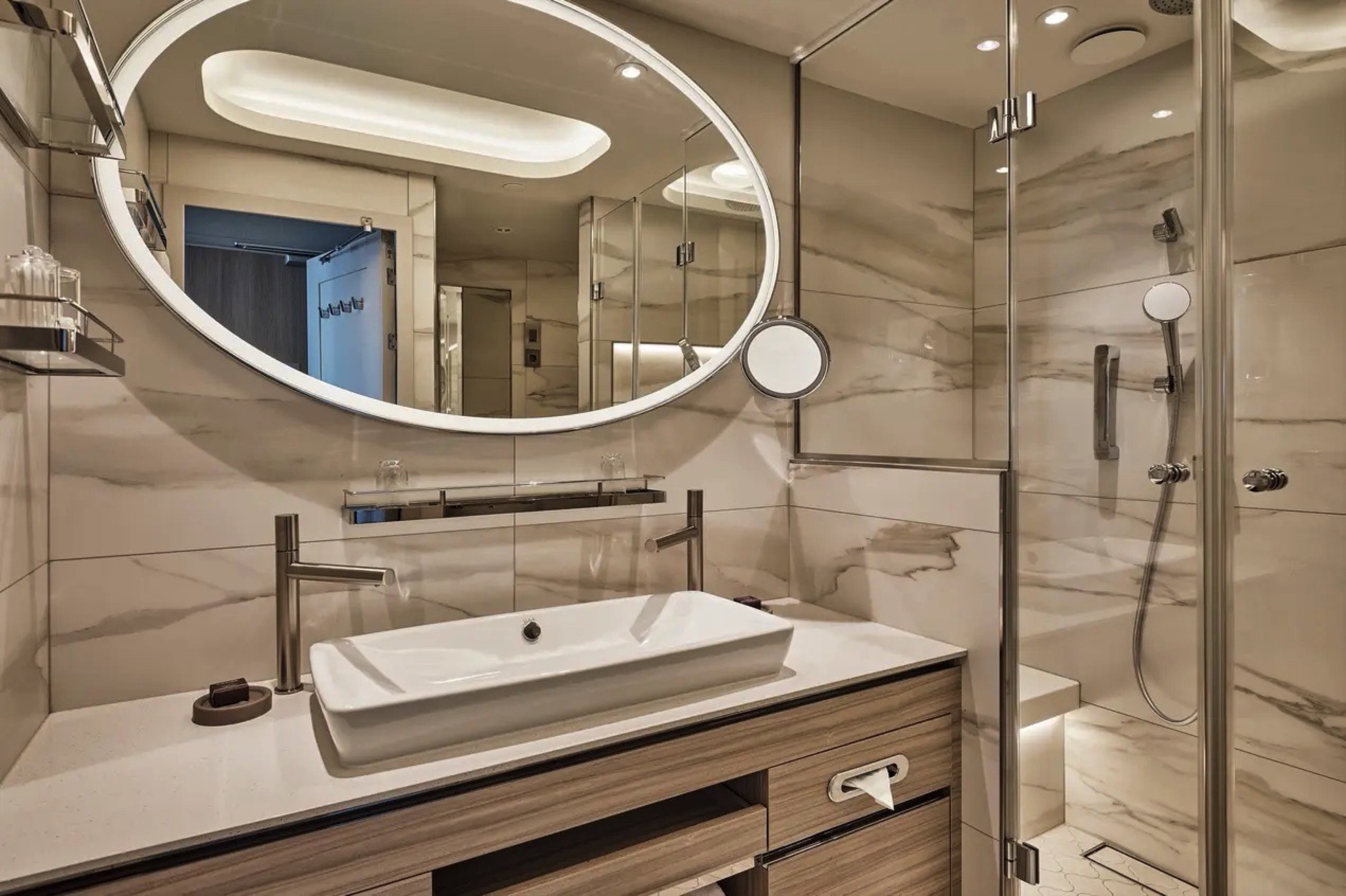
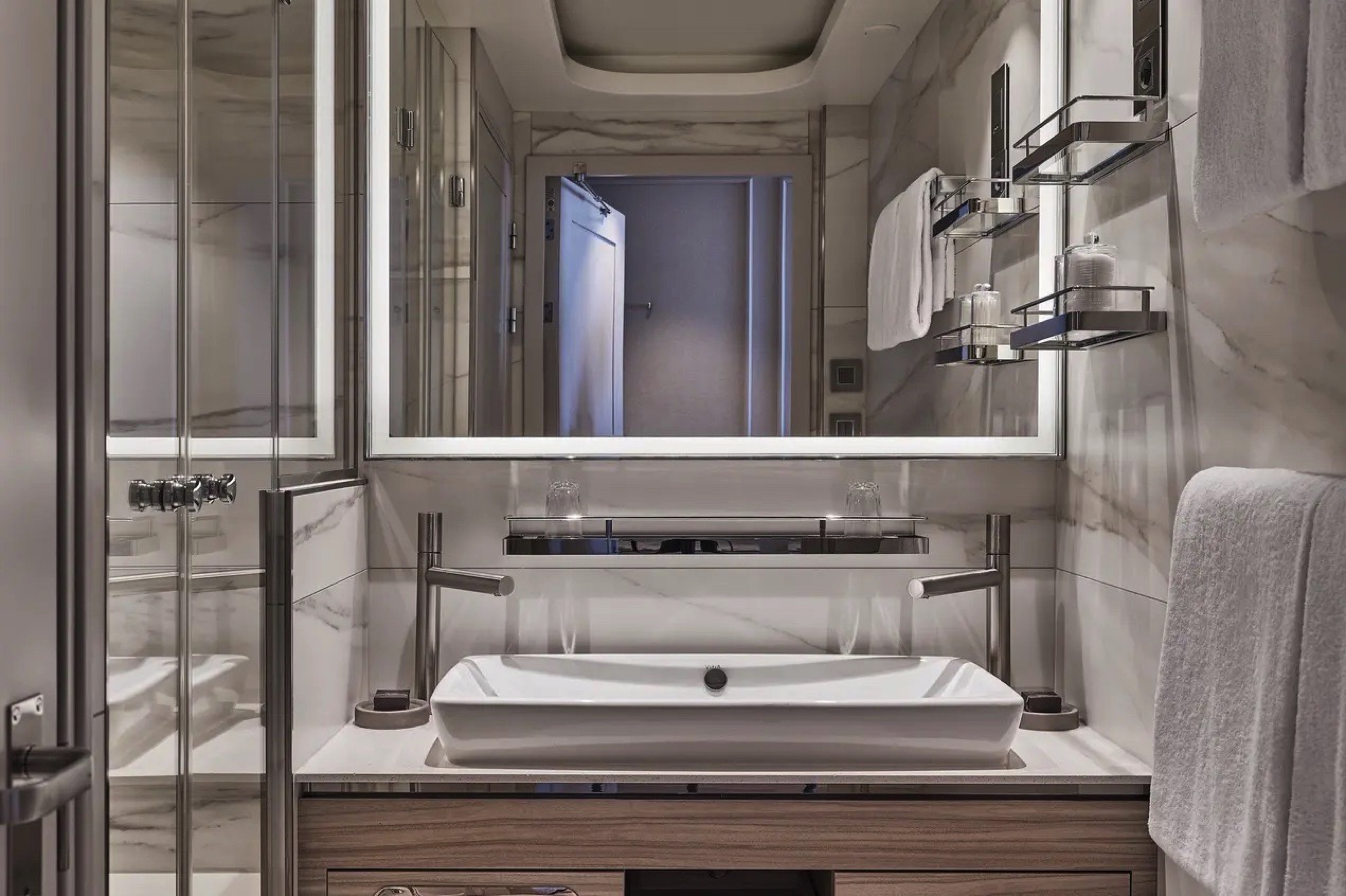
The main bedroom has a large walk-in wardrobe with a personal safe and a bathroom with a double vanity, walk-in shower, and whirlpool bath.
The second bedroom has a separate wardrobe and a bathroom with a walk-in shower.
Essentials
- Deck(s): 7
- Section: Forward, Starboard
Characteristics
- Large Veranda with floor-to-ceiling glass doors
- Separate dining area
- Living room with sitting area
- Double vanity
- Walk-in shower
- Whirlpool bath
- Walk-in wardrobe with personal safe
Furniture
- Twin beds or king-size bed
- Writing desk
- Luxury bed mattresses
Media & Communication
- Unlimited Premium Wi-Fi
- 3 large flat screen TVs with Interactive Media Library
- Sound system with bluetooth connectivity
- Direct dial telephone
- Wall mounted USB-C mobile device chargers
Onboard Services
- Butler service
- Complimentary laundry, pressing & wet cleaning
- Dinner for two in La Dame, one evening per voyage,
- Two hours of worldwide phone use, per voyage segment
- Champagne on arrival
Amenities
- Espresso machine
- Tea kettle
- Pillow menu
- Refrigerator and bar setup stocked with your preferences
- Plush bathrobe
- Luxury bath amenities
- Umbrella
- Hair Dryer
- Slippers
Images are intended as a general reference. Features, materials, finishes and layout may be different than shown.
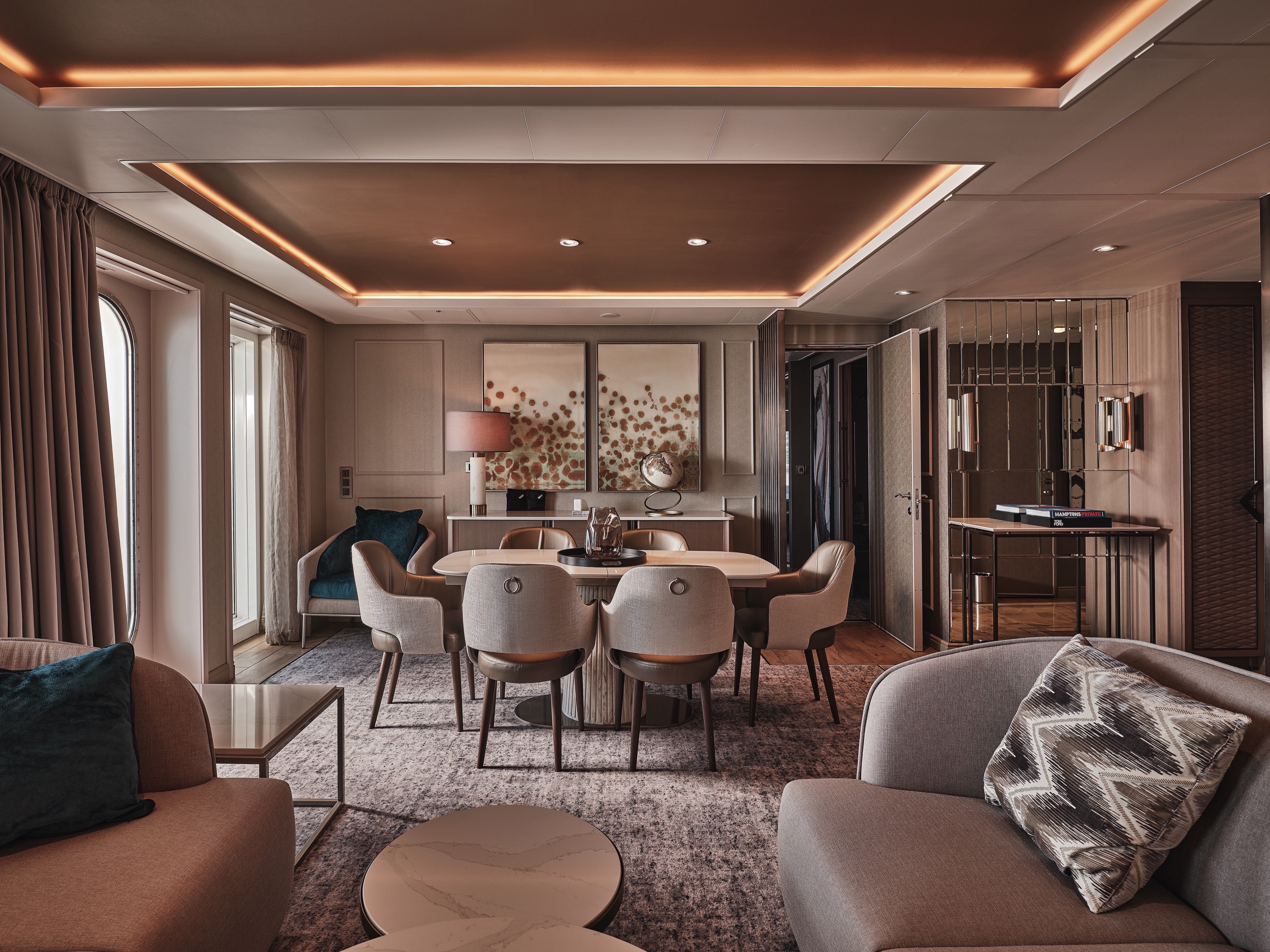
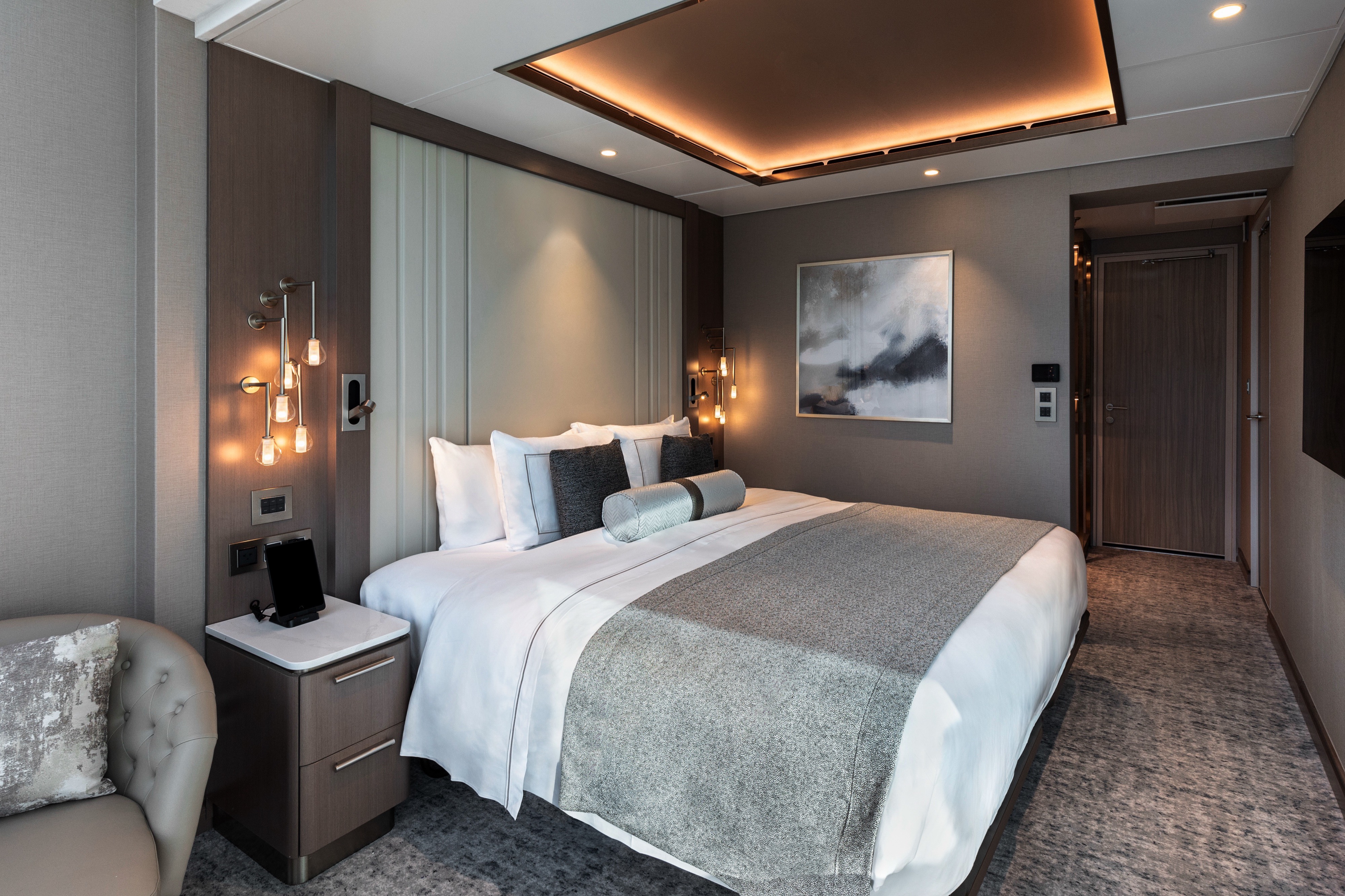
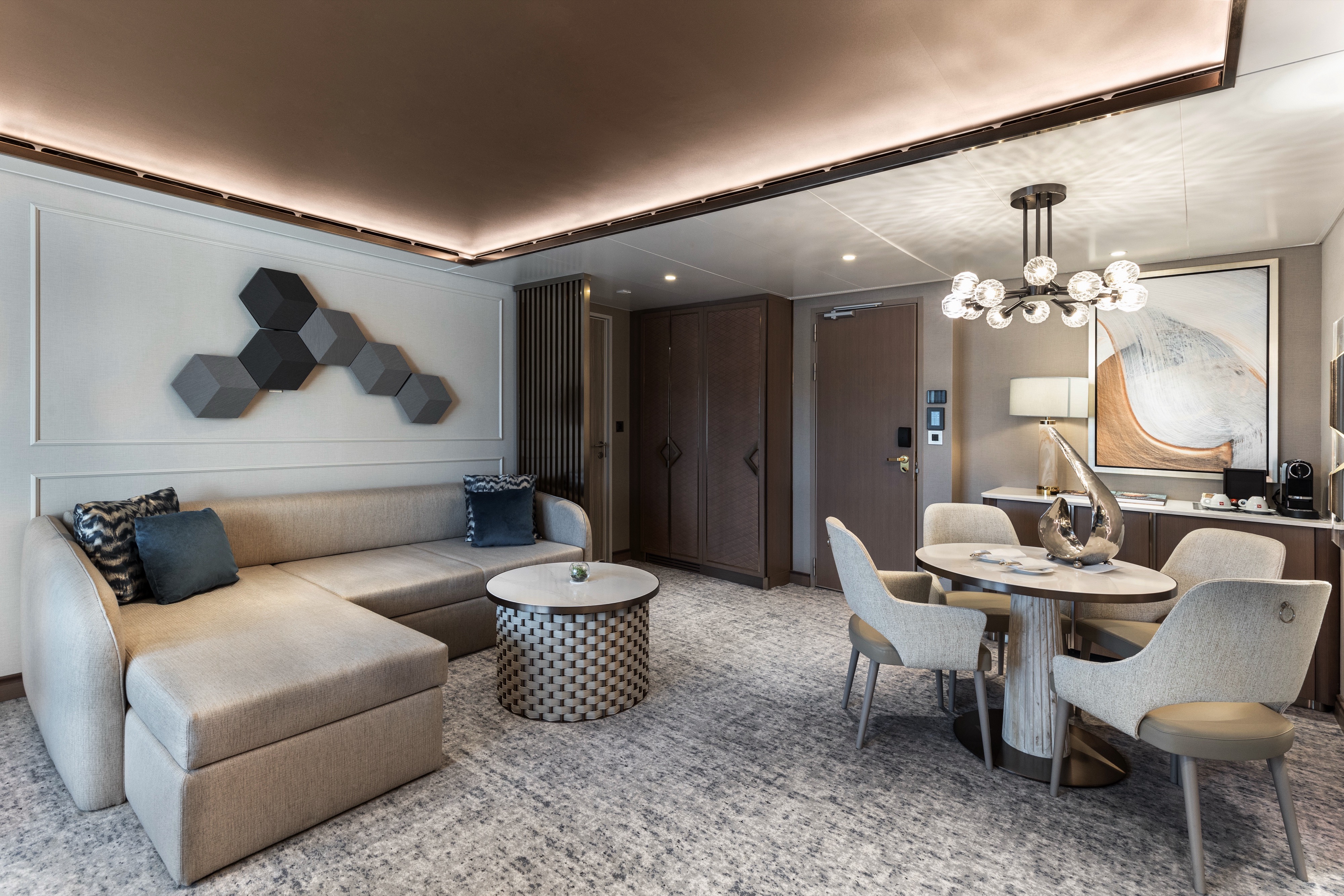
The Grand Suite is one of the most luxurious and spacious suites on board Silver Endeavour. It guarantees sweeping views of your destination thanks to its large balcony. A spacious interior includes a large living room, separate dining area, and large bedroom with a big walk-in wardrobe. A luxurious bathroom includes a double vanity, whirlpool bath, and walk-in shower. In addition, the Grand Suite also includes a small, second bedroom able to accommodate a third berth.
One bedroom: 155 sq m (64 sq m)
Two bedrooms: 188.1 sq m (69 sq m)
Essentials
- Deck(s): 7
- Section: Forward, Port
Characteristics
- Large Veranda with floor-to-ceiling glass doors
- Separate dining area
- Living room with sitting area
- Double vanity
- Walk-in shower
- Whirlpool bath
- Walk-in wardrobe with personal safe
Furniture
- Twin beds or king-size bed and a single bed in additional bedroom
- Writing desk
- Vanity table
- Luxury bed mattresses
Media & Communication
- Unlimited Premium Wi-Fi
- 2 large flat screen TVs with Interactive Media Library
- Sound system with bluetooth connectivity
- Direct dial telephone
- Wall mounted USB-C mobile device chargers
Onboard Services
- Butler service
- Complimentary laundry, pressing & wet cleaning
- Dinner for two in La Dame, one evening per voyage,
- Two hours of worldwide phone use, per voyage segment
- Champagne on arrival
Amenities
- Espresso machine
- Pillow menu
- Refrigerator and bar setup stocked with your preferences
- Plush bathrobe
- Luxury bath amenities
- Umbrella
- Hair Dryer
- Slippers
A third guest can be accommodated in an additional single-bed bedroom.
Images are intended as a general reference. Features, materials, finishes and layout may be different than shown.
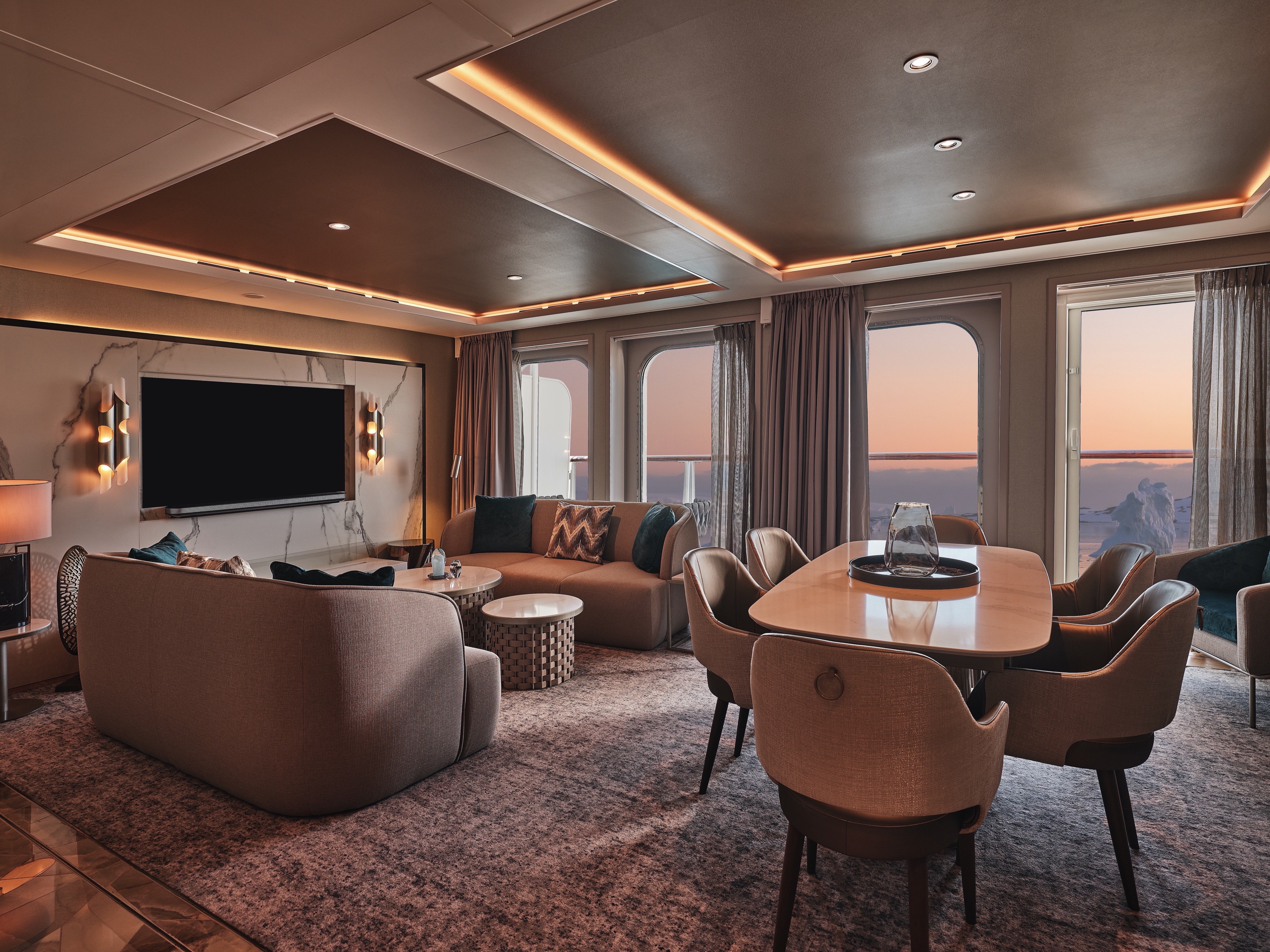
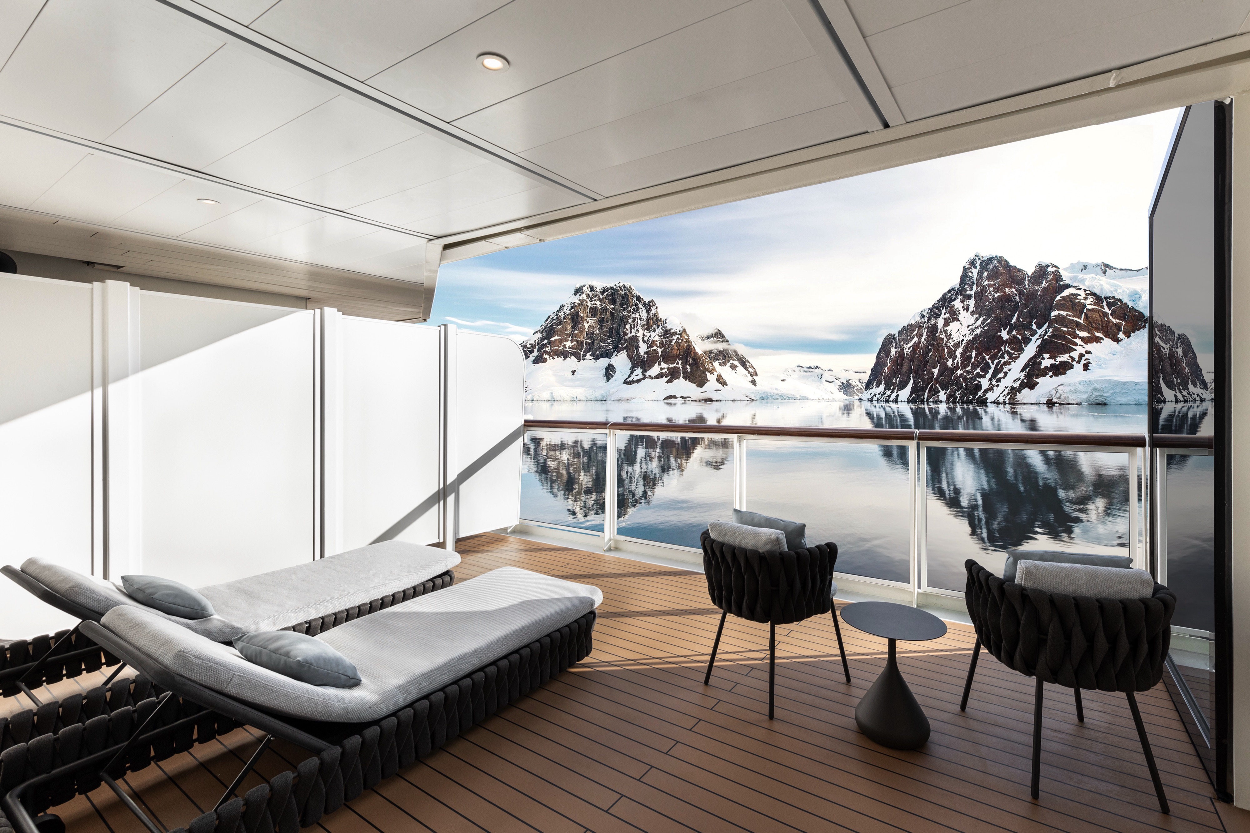
One of our most sumptuous suites ever designed! With innovative domed glazing surrounding the living areas and one of the largest balconies on board, the Master Suite offers complete destination immersion at sea. Floor-to-ceiling windows provide wow-factor 270-degree views while the beautifully appointed living and dining areas, separate bedroom, and bathroom with walk-in shower and whirlpool bath ensure complete in-suite comfort. If you have ever wanted to experience expedition travel while not missing out on luxury, Silver Endeavour’s Master Suite is the answer.
One bedroom: 108 sq m (25.8 sq m)
Essentials
- Deck(s): 8
- Section: Aft
Characteristics
- Large Veranda with floor-to-ceiling glass doors
- Separate dining area
- Living room with sitting area
- Double vanity
- Walk-in shower
- Whirlpool bath
- Walk-in wardrobe with personal safe
Furniture
- King size bed
- Writing desk
- Luxury bed mattresses
Media & Communication
- Unlimited Premium Wi-Fi
- 2 large flat screen TVs with Interactive Media Library
- Sound system with bluetooth connectivity
- Direct dial telephone
- Wall mounted USB-C mobile device chargers
Onboard Services
- Butler service
- Complimentary laundry, pressing & wet cleaning
- Two hours of worldwide phone use, per voyage segment
- Champagne on arrival
Amenities
- Espresso machine
- Tea kettle
- Pillow menu
- Refrigerator and bar setup stocked with your preferences
- Plush bathrobe
- Luxury bath amenities
- Umbrella
- Hair Dryer
- Slippers
Images are intended as a general reference. Features, materials, finishes and layout may be different than shown.
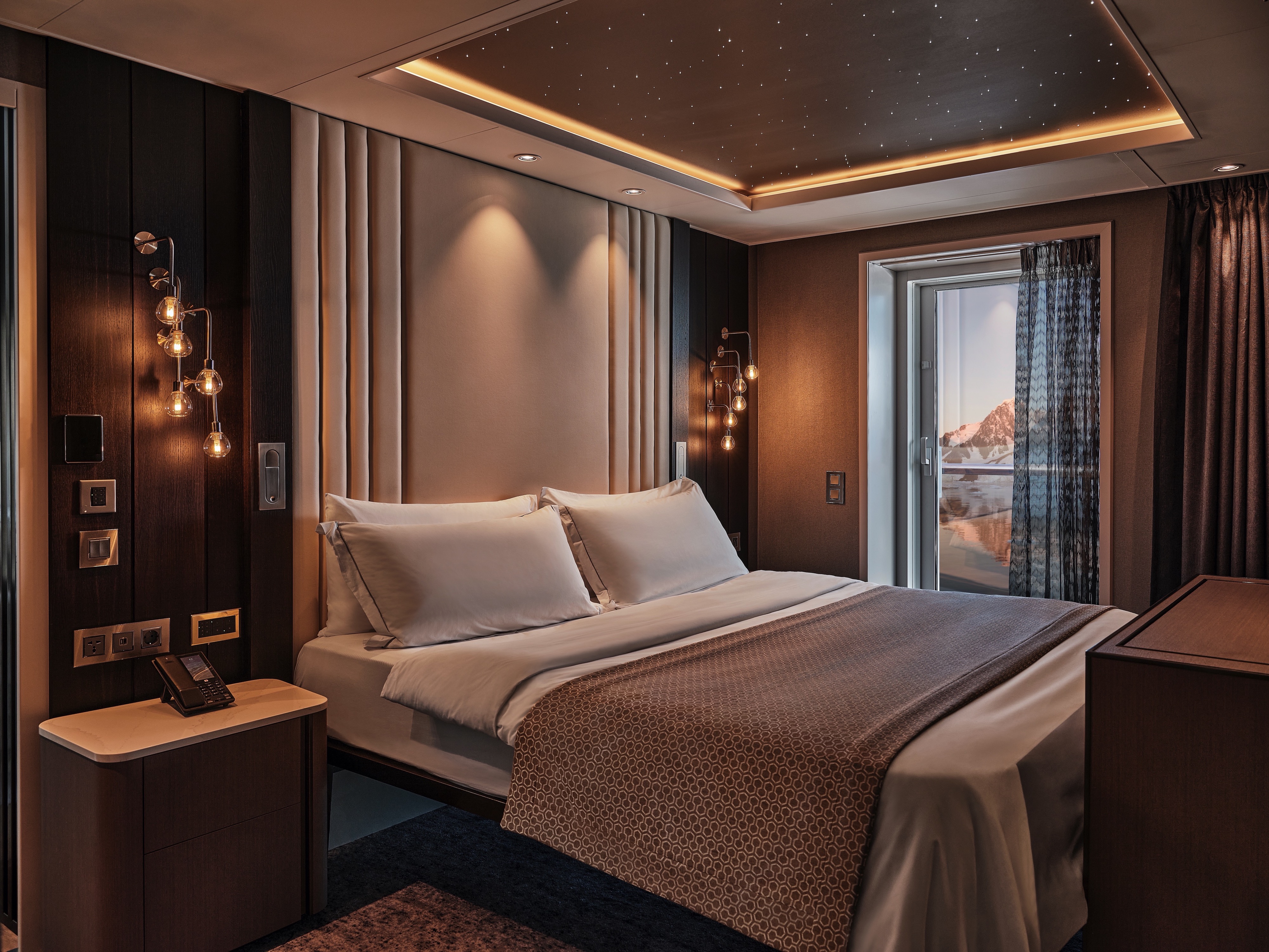
Get closer to your destination with Silver Endeavour’s Signature Suite! Located on deck 8, this beautiful accommodation offers a wonderfully large living room, a dining area, a separate bedroom, and a bathroom with walk-in shower and whirlpool bath. But surely the best thing about the Signature Suite is the huge private veranda and floor-to-ceiling glass walls, offering you sweeping views whether you are at the tip or toe of the world. The Signature Suite is one of our favorite places to enjoy serene polar landscapes after a day of onshore exploring.
One bedroom: 67–78 sq m (16–22 sq m )
Essentials
- Deck(s): 8
- Section: Aft, Mid-Ship
Characteristics
- Large Veranda with floor-to-ceiling glass doors
- Separate dining area
- Living room with sitting area
- Double vanity
- Walk-in shower
- Whirlpool bath
- Walk-in wardrobe with personal safe
Furniture
- King size bed
- Writing desk
- Luxury bed mattresses
Media & Communication
- Unlimited Premium Wi-Fi
- 2 large flat screen TVs with Interactive Media Library
- Sound system with bluetooth connectivity
- Direct dial telephone
- Wall mounted USB-C mobile device chargers
Onboard Services
- Butler service
- Complimentary laundry, pressing & wet cleaning
- Two hours of worldwide phone use, per voyage segment
- Champagne on arrival
Amenities
- Espresso machine
- Tea kettle
- Pillow menu
- Refrigerator and bar setup stocked with your preferences
- Plush bathrobe
- Luxury bath amenities
- Umbrella
- Hair Dryer
- Slippers
Images are intended as a general reference. Features, materials, finishes and layout may be different than shown.
No Silversea ship would be complete without our guests’ favorite Silver Suite. Located on deck 8, the Silver Suite promises stunning views of the destination thanks to its floor-to-ceiling window and large balcony. The spacious living area allows for comfortable relaxation while the dining area makes cozy nights in veritable experiences in themselves. Additionally, Silver Suites feature generous walk-in wardrobes as well as a bathroom with a large walk-in shower, vanity, and separate lavatory.
One bedroom: 49.7 sq m (7 sq m)
Essentials
- Deck(s): 8
- Section: Mid-Ship
Characteristics
- Veranda
- Separate dining area
- Living room with sitting area
- Double vanity
- Walk-in shower
Furniture
- Writing desk
- Vanity table
- Luxury bed mattresses
Media & Communication
- Unlimited Premium Wi-Fi
- 2 large flat screen TVs with Interactive Media Library
- Sound system with bluetooth connectivity
- Direct dial telephone
- Wall mounted USB-C mobile device chargers
Onboard Services
- Butler service
- Complimentary laundry, pressing & wet cleaning
- Champagne on arrival
Amenities
- Espresso machine
- Tea kettle
- Pillow menu
- Refrigerator and bar setup stocked with your preferences
- Plush bathrobe
- Luxury bath amenities
- Umbrella
- Hair Dryer
- Slippers
Please note that the third guest will sleep on a comfortable sofa bed in the reception area of the suite.
Images are intended as a general reference. Features, materials, finishes and layout may be different than shown.
Our best-selling Premium Veranda Suite is more beautiful and luxurious than ever on board Silver Endeavour. This suite offers a large bedroom space with dreamy bedding, a stunning marbled bathroom with a large vanity, and sumptuous walk-in shower. Comfortable furnishings and elegant decor make staying in (almost) as good as going out! Spacious and well-situated, enjoy ultra-luxury amenities from the 24-hour butler service to the well-stocked mini-bar (and yes, they’re all included!). The sofa bed can easily accommodate a third guest.
One bedroom: 33.1 sq m (5 sq m)
Essentials
- Deck(s): 6, 7
- Section: Forward, Mid-Ship
Characteristics
- Veranda
- Sitting area
- Large vanity
- Walk-in shower
Furniture
- King size bed
- Writing desk
- Vanity table
- Luxury bed mattresses
Media & Communication
- Unlimited Standard Wi-Fi
- 1 large flat screen TV with Interactive Media Library
- Direct dial telephone
- Wall mounted USB-C mobile device chargers
Onboard Services
- Butler service
- Champagne on arrival
Amenities
- Pillow menu
- Refrigerator and bar setup stocked with your preferences
- Plush bathrobe
- Luxury bath amenities
- Umbrella
- Hair Dryer
- Slippers
Please note that the third guest will sleep on a comfortable sofa bed in the reception area of the suite.
Images are intended as a general reference. Features, materials, finishes and layout may be different than shown.
Deluxe Veranda Suites keep the iconic suite configuration—one of the most successful in the industry—while enhancing your creature comforts and destination immersion. Located on the privileged upper-mid levels, Deluxe Veranda Suites have spacious interiors with a bedroom area that includes a large writing desk and comfortable living room with a convertible sofa (able to accommodate a third berth). Even better, the balcony is larger and more beautiful than ever, offering ample space to relax and enjoy sweeping views, wherever you are.
One bedroom: 33.1 sq m (5 sq m)
Essentials
- Deck(s): 6, 7
- Section: Aft, Mid-Ship
Characteristics
- Veranda
- Sitting area
- Large vanity
- Walk-in shower
Furniture
- King size bed
- Writing desk
- Vanity table
- Luxury bed mattresses
Media & Communication
- Unlimited Standard Wi-Fi
- 1 large flat screen TV with Interactive Media Library
- Direct dial telephone
- Wall mounted USB-C mobile device chargers
Onboard Services
- Butler service
- Champagne on arrival
Amenities
- Pillow menu
- Tea kettle
- Refrigerator and bar setup stocked with your preferences
- Plush bathrobe
- Luxury bath amenities
- Umbrella
- Hair Dryer
- Slippers
Please note that the third guest will sleep on a comfortable sofa bed in the reception area of the suite.
Images are intended as a general reference. Features, materials, finishes and layout may be different than shown.
The Superior Veranda Suite is found on the upper decks. From the sumptuous views from the teak veranda to the spacious sitting room (with a sofa bed able to accommodate a third berth) and large marble bathroom, everything about the Superior Veranda has been designed for your comfort. A comfortable living space, attention to detail, and a generous expanse of amenities make this stunning suite a cozy home while on the seas.
One bedroom: 33.1 sq m (5 sq m)
Essentials
- Deck(s): 6, 7, 8
- Section: Aft, Forward, Mid-Ship
Characteristics
- Veranda
- Sitting area
- Large vanity
- Walk-in shower
Furniture
- King size bed
- Writing desk
- Vanity table
- Luxury bed mattresses
Media & Communication
- Unlimited Standard Wi-Fi
- 1 large flat screen TV with Interactive Media Library
- Direct dial telephone
- Wall mounted USB-C mobile device chargers
Onboard Services
- Butler service
- Champagne on arrival
Amenities
- Pillow menu
- Tea kettle
- Refrigerator and bar setup stocked with your preferences
- Plush bathrobe
- Luxury bath amenities
- Umbrella
- Hair Dryer
- Slippers
Please note that the third guest will sleep on a comfortable sofa bed in the reception area of the suite.
Images are intended as a general reference. Features, materials, finishes and layout may be different than shown.
Located on the lower decks in the bow, the Classic Veranda Suite offers all the comfort and attention to detail that you can expect aboard—both inside and out. A generous expanse of interior comforts—elegant decor, a stunning marble bathroom, and ample seating area (with a sofa bed that is able to accommodate a third berth)—offers everything you need for a comfortable cruise. But perhaps this suite’s finest asset lies just outside, as floor-to-ceiling glass doors open onto a private veranda, making every sunset feel as if it is yours alone.
One bedroom: 33.1 sq m (5 sq m)
Essentials
- Deck(s): 5, 6
- Section: Forward, Mid-Ship
Characteristics
- Veranda
- Sitting area
- Large vanity
- Walk-in shower
Furniture
- King size bed
- Writing desk
- Vanity table
- Luxury bed mattresses
Media & Communication
- Unlimited Standard Wi-Fi
- 1 large flat screen TV with Interactive Media Library
- Direct dial telephone
- Wall mounted USB-C mobile device chargers
Onboard Services
- Butler service
- Champagne on arrival
Amenities
- Pillow menu
- Tea kettle
- Refrigerator and bar setup stocked with your preferences
- Plush bathrobe
- Luxury bath amenities
- Umbrella
- Hair Dryer
- Slippers
Wheelchair accessible suite: 508. The suite has a bathroom with vanity and shower.
Please note that the third guest will sleep on a comfortable sofa bed in the reception area of the suite.
Images are intended as a general reference. Features, materials, finishes and layout may be different than shown.
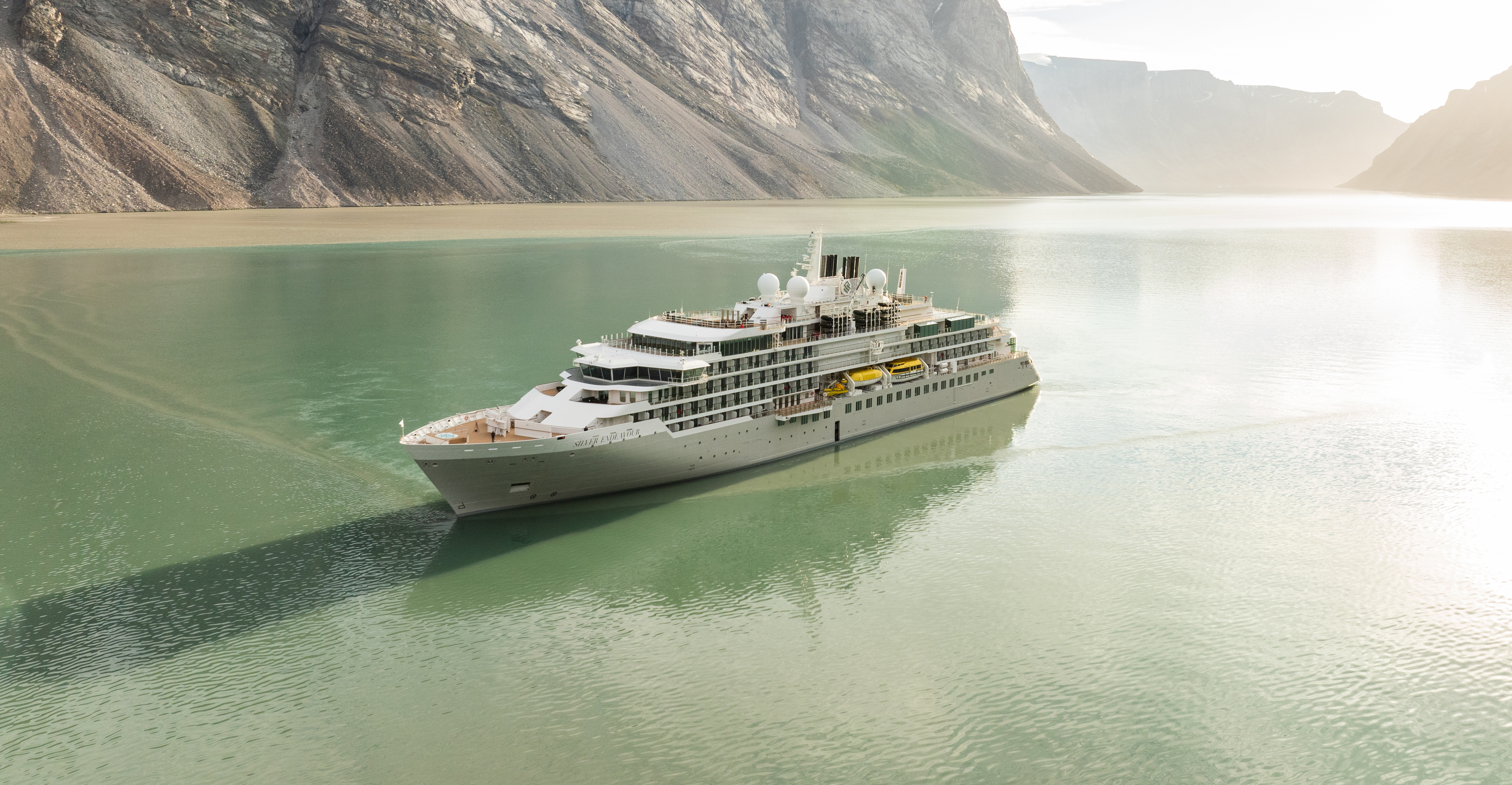
Silver Endeavour
Silver Endeavour revolutionizes our expedition voyages and allows deeper travel to some of the planet’s farthest-flung coasts. Her statistics speak for themselves: unrivaled, industry-leading crew-to-guest, Zodiac-to-guest, and expert-to-guest ratios, cutting-edge navigation and exploration technology, and hallmark Silversea comfort make her the most luxurious expedition ship ever built.
Ship Facts
| Launch Year | 2021 | ||||||||
| Refit Year | |||||||||
| Language | en | ||||||||
| Gross Tonnage | 20649 | ||||||||
| Length | 165 | ||||||||
| Width | 25 | ||||||||
| Currency | USD | ||||||||
| Speed | 19 | ||||||||
| Capacity | 220 | ||||||||
| Crew Count | 207 | ||||||||
| Deck Count | 8 | ||||||||
| Cabin Count | 110 | ||||||||
| Large Cabin Count | N/A | ||||||||
| Wheelchair Cabin Count | N/A | ||||||||
| Electrical Plugs |
|
Deck 10
- Sun Deck

Deck 9
- Observation Lounge
- Library

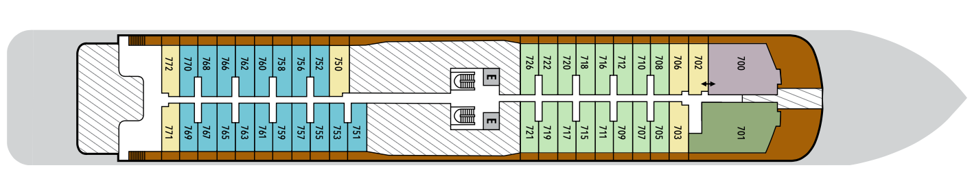
Deck 8
- Master Suite
- Superior Veranda Suite
- Signature Suite
- Silver Suite
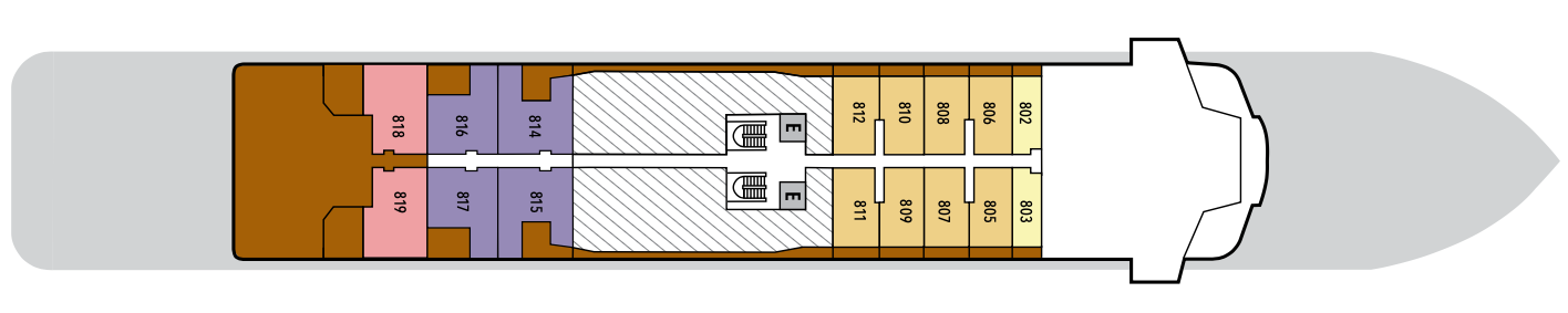
Deck 7
- Owner's Suite
- Grand Suite
- Premium Veranda Suite
- Deluxe Veranda Suite
- Superior Veranda Suite
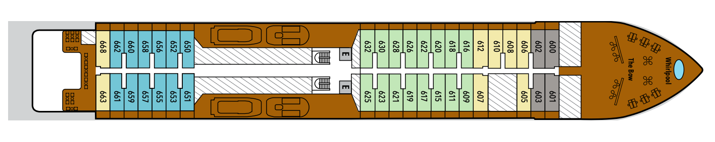
Deck 6
- Whirlpool
- The Bow
- Classic Veranda Suite
- Premium Veranda Suite
- Superior Veranda Suite
- Deluxe Veranda Suite
Deck 5
- Classic Veranda Suite
- Arts Café
- Beauty Salon
- Reception
- Future Cruise Sales
- Fitness Centre
- Otium Spa
- Boutique
- Pool Deck
- The Grill
- Whirlpool
Deck 4
- Medical Centre
- Explorer Lounge
- La Dame
- Connoisseur's Corner
- II Terrazzino
- The Restaurant
Deck 3
- Mud Room
- Marina
- Launderette
Dive into a world of fine dining aboard Silver Endeavour. Enjoy haute cuisine at the tip and toe of the world, dining in some of the most remote and remarkable destinations on the planet. Enjoy authentic Italian recipes that span generations in Il Terrazzino. Or why not get lost in the glacial views of The Grill while you savor some of the best international options at sea. Our famous La Dame French restaurant promises exquisite gastronomie à la française in both polar regions, while the Arts Café is the place to be for healthy daytime treats. Whether you’re in the Arctic or Antarctica, dining aboard Silver Endeavour promises to be quite special.
II Terrazzino
Exclusive to Silver Endeavour, Il Terrazzino offers an authentic taste of Italy in an intimate setting. Old-World recipes and exquisite pastas meet contemporary artistry over dinner, accompanied by wines selected from exceptional vineyards across the globe. The result is an elegant homage to Italy’s culinary heart.
Images are intended as a general reference. Features, materials, finishes and layout may be different than shown.
The Restaurant
The Restaurant transforms dining into an extraordinary journey of taste. Indulge in international delicacies, refined classics, and destination-driven creations that reflect the flavors of the region you’re exploring. From breakfast favorites to imaginative evening courses, every meal draws inspiration from your voyage.
Images are intended as a general reference. Features, materials, finishes and layout may be different than shown.
Arts Café
Arts Café is a vibrant, light-filled haven for conversation, creativity, and indulgence. Snack on light bites and decadent pastries paired with freshly brewed coffee and artisanal teas as you unwind with a good book or get to know your fellow travelers.
Images are intended as a general reference. Features, materials, finishes and layout may be different than shown.
La Dame
Experience the pinnacle of French gastronomy at La Dame, where sophistication meets tradition. Here, an exclusive tasting menu unfolds course by course — each plate a study in masterful technique, seasonal ingredients, and modern refinement. From classic Kir Royales to exquisite signatures such as Dover sole à la Grenobloise, this is haute cuisine at its finest.
Images are intended as a general reference. Features, materials, finishes and layout may be different than shown.
The Grill
A poolside al fresco favorite, The Grill is casual by day and captivating by night. Dig in to crisp salads and grilled classics during lunch, then return after sunset for masterfully seasoned and seared cuts paired with balmy sea breezes.
Images are intended as a general reference. Features, materials, finishes and layout may be different than shown.
In-Suite Dining
You can order from our Room Service menu 24 hours a day.
Opening hours are for reference only. For precise opening hours, please refer to the Daily Chronicles provided on board.
Channel the same sense of discovery that guided pioneering explorers of yesteryear thanks to Silver Endeavour’s cutting-edge design. Join interactive and informative lectures, learn about your destination from our guides, or simply prepare for your day ashore the comfortable Observation and Explorer lounges. Gaze at the unobstructed, jaw-dropping landscape outside from the warmth of the glazed indoor areas while splashing around in the pool or enjoying a quiet coffee. From doing a spot of whale watching to cozying up with a book and a blanket from the sun deck, Silver Endeavour endeavors to give you the best expedition experience at sea in the world.
Explorer Lounge
Unique to our Expedition ships, the Explorer Lounge is a versatile venue that adapts to the rhythm of your journey. Comfortable seating and refined refreshments create an atmosphere where learning and leisure meld seamlessly. From lectures and presentations to live entertainment and special events, this is a space where discovery thrives.
Images are intended as a general reference. Features, materials, finishes and layout may be different than shown.
Library
Whether you’re an avid bibliophile or simply prefer a quiet place while at sea, it’s hard not to fall in love with Silver Endeavour’s onboard library. Located on deck 9, the Library offers a comfortable and intimate enrichment space, where you can educate yourself from one of the beautiful reference books, curl up with a novel in one of the comfortable chairs, or simple gaze amazed at the stunning scenery as its floats serenely by.
Images are intended as a general reference. Features, materials, finishes and layout may be different than shown.
Observation Lounge
Wrapped in glass and bathed in light, the Observation Lounge offers a serene escape high above the sea. Borrow a book from the in-house library, pour yourself a coffee or tea from the self-service bar, and curl into an armchair to watch the world drift by. This is a sanctuary for reflection, relaxation, and stories — both written and still in the making.
Images are intended as a general reference. Features, materials, finishes and layout may be different than shown.
Sun Deck
Cozy up with a book and a blanket from the sun deck.
Images are intended as a general reference. Features, materials, finishes and layout may be different than shown.
Connoisseur's Corner
As evening stretches into night, Connoisseur’s Corner offers a stylish refuge for those who appreciate the time-honored rituals of smoke and spirit. Sink into tufted leather chairs with a hand-rolled cigar and a glass of one of our finest cognacs or whiskeys. Indoors or under the stars, every moment is marked by pure indulgence.
Images are intended as a general reference. Features, materials, finishes and layout may be different than shown.
Boutique
Our committed and competent team of beauty therapists is here to help keep your hair, nails, skin, and body healthy and happy. In addition to our regular beauty services, such as pedicures, manicures, and the latest in trendy hairstyles, we offer makeup application so you look great on a special evening, waxing, and teeth whitening. What’s more, our Emperor’s Chair services make sure that gentlemen aren’t forgotten.
Images are intended as a general reference. Features, materials, finishes and layout may be different than shown.