
Seward (Anchorage to Tokyo
Seward (Anchorage to Tokyo
Cruise overview
WHY BOOK WITH US?
- ✔ The Deluxe Cruises’ team has extensive experience in ultra-luxury cruising.
- ✔ Call now to speak to our helpful and experienced Cruise Concierge team.
- ✔ Enjoy our Unique Deluxe Cruises Bonus for substantial savings.
- ✔ Our team will tailor your holiday to your exacting requirements.
- ✔ As agents, we work under the protection of each cruise lines ABTA / ATOL licences
About Seward, Alaska
It is hard to believe that a place as beautiful as Seward exists. Surrounded on all sides by Kenai Fjords National Park, Chugach National Forest, and Resurrection Bay, Seward offers all the quaint realities of a small railroad town with the bonus of jaw-dropping scenery. This little town of about 2,750 citizens was founded in 1903, when survey crews arrived at the ice-free port and began planning a railroad to the Interior. Since its inception, Seward has relied heavily on tourism and commercial fishing. It is also the launching point for excursions into Kenai Fjords National Park, where it is quite common to see marine life and calving glaciers.


About Kodiak, Alaska
Today, commercial fishing is king in Kodiak. Despite its small population—about 6,475 people scattered among the several islands in the Kodiak group—the city is among the busiest fishing ports in the United States. The harbor is also an important supply point for small communities on the Aleutian Islands and the Alaska Peninsula.Visitors to the island tend to follow one of two agendas: either immediately fly out to a remote lodge for fishing, kayaking, or bear viewing; or stay in town and access whatever pursuits they can reach from the limited road system. If the former is too pricey an option, consider combining the two: drive the road system to see what can be seen inexpensively, then add a fly-out or charter-boat excursion to a remote lodge or wilderness access point.Floatplane and boat charters are available from Kodiak to many remote attractions, chief among them the Kodiak National Wildlife Refuge , which covers four islands in the Gulf of Alaska: Kodiak, Afognak, Ban, and Uganik.

About Kushiro
Kushiro, known as the "town of mist", is situated in the south eastern part of Hokkaido. With about 200,000 inhabitants, it is the largest city in the region and the base for deep-sea fishing. The marine products industry of Kushiro has flourished since the early 20 th century and many streets of this port town retain features of this era. Thanks to its strategic location on Hokkaido's Eastern Pacific seaboard and the area's only ice free port, Kushiro is experiencing steady growth as an important economic, social and cultural centre. A literary atmosphere can be attributed to the poet and novelist Takuboku Ishikawa, who lived here in the early 20th century. To the north of Kushiro lies one of its most renowned attractions, the Kushiro Shitsugen, Japan's largest marshland. Stretching out over the majority of the Kushiro Plain, it accounts for 60 percent of Japan's wetland and was designated to become the country's 28th National Park in 1987. As the marsh is considered one of the greatest treasure houses of flora and fauna in Japan, its protection, preservation and wise use are promoted by a national agreement. Equally famous is the marshland as the habitat of the Tancho (Japanese Crane). At one time, it could be seen in many places in Japan, but their numbers dwindled in the Meiji Era due to over hunting and environmental changes. In the late 19 th century, the cranes were thought to be almost extinct. Then several dozens cranes were discovered in the depths of the Kushiro Shitsugen, and after establishing special crane reserves, the birds rehabilitation has succeeded.

About Hakodate
Facing out on two bays, Hakodate is a 19th-century port town, with clapboard buildings on sloping streets, a dockside tourist zone, streetcars, and fresh fish on every menu. In the downtown historic quarter, a mountain rises 1,100 feet above the city on the southern point of the narrow peninsula. Russians, Americans, Chinese, and Europeans have all left their mark; this was one of the first three Japanese ports the Meiji government opened up to international trade in 1859. The main sights around the foot of Mt. Hakodate can be done in a day, but the city is best appreciated with an overnight stay for the illumination in the historic area, the night views from either the mountain or the fort tower, and the fish market at dawn. City transport is easy to navigate and English information is readily available. Evening departure trains from Tokyo arrive here at dawn—perfect for fish-market breakfasts.


About Aomori
Aomori's main event is its Nebuta Matsuri Festival,held August 2 to 7. People come to see illuminated floats of gigantic samurai figures paraded through the streets at night. Aomori's festival is one of Japan's largest, and is said to celebrate the euphoria of post-battle victory, and is thus encouraged to be noisier and livelier than you may have been exposed to in other Japanese festivals. Dancers, called heneto, run alongside the floats, dancing crazily, and you're encouraged to join in. Throughout the year you can enjoy delicious seafood from Aomori Bay, including Oma no Maguro (tuna of Oma), as well as delicious fruits and vegetables (particularly garlic). And come every summer, the town cuts loose to throw the decidedly wild Nebuta Matsuri festival, a frenzied, utterly unaccountable period when normal gets thrown to the wind.

About Akita


About Niigata
Niigata city is the capital of Niigata prefecture and faces the Japan Sea on the island of Honshu, the largest of the four islands that comprise Japan. With a population of 810,000, Niigata is the largest Honshu city along the Japan Sea coast. The city is located at 300 km northwest of Tokyo and the bullet train would take you there in only two hours. Niigata offers four distinct seasons throughout the year, and people may find the winter season to be the best time to visit as many people would come for winter sports such as skiing or snowboarding. However, you will find the place abundantly beautiful throughout the year as well. Niigata is famous for growing rice as well as fresh seafood. If you try white rice without any seasonings, you would be able to taste the difference and appreciate its flavour. Thanks to the quality of the rice, they produce great Sake in the area. If you have time, why don’t you extend your journey to one of the famous Sake Brewery?


About Kanazawa
The capital of the Ishikawa Prefecture, Kanazawa once rivalled Kyoto and Edo (Tokyo) as a town rich in cultural achievements. Kanazawa escaped destruction during World War II and accordingly has been able to preserve many of the old districts in good shape. The city is famous because of Kenrokuen. Located next to Kanazawa Castle, Kenrokuen is classified as “One of the Three Gardens of Japan”. The garden has an artificial pond, and hills and houses are dotted within the 11.4 hectares. It has Japan’s oldest fountain using natural water pressure and a tea-house dating back to 1774. Close by is the Higashi Chaya Gai Geisha District, designated a National Cultural Asset and the biggest of the Geisha districts of Kanazawa. Some of the houses not only retain the original structure, but still are used as Geisha houses. Some of the streets have traditional shops creating a nostalgic atmosphere. Kanazawa is also known for its lacquer ware, Kutani-style pottery, gold-leaf workmanship and delicately painted silk kimonos.

About Hiroshima
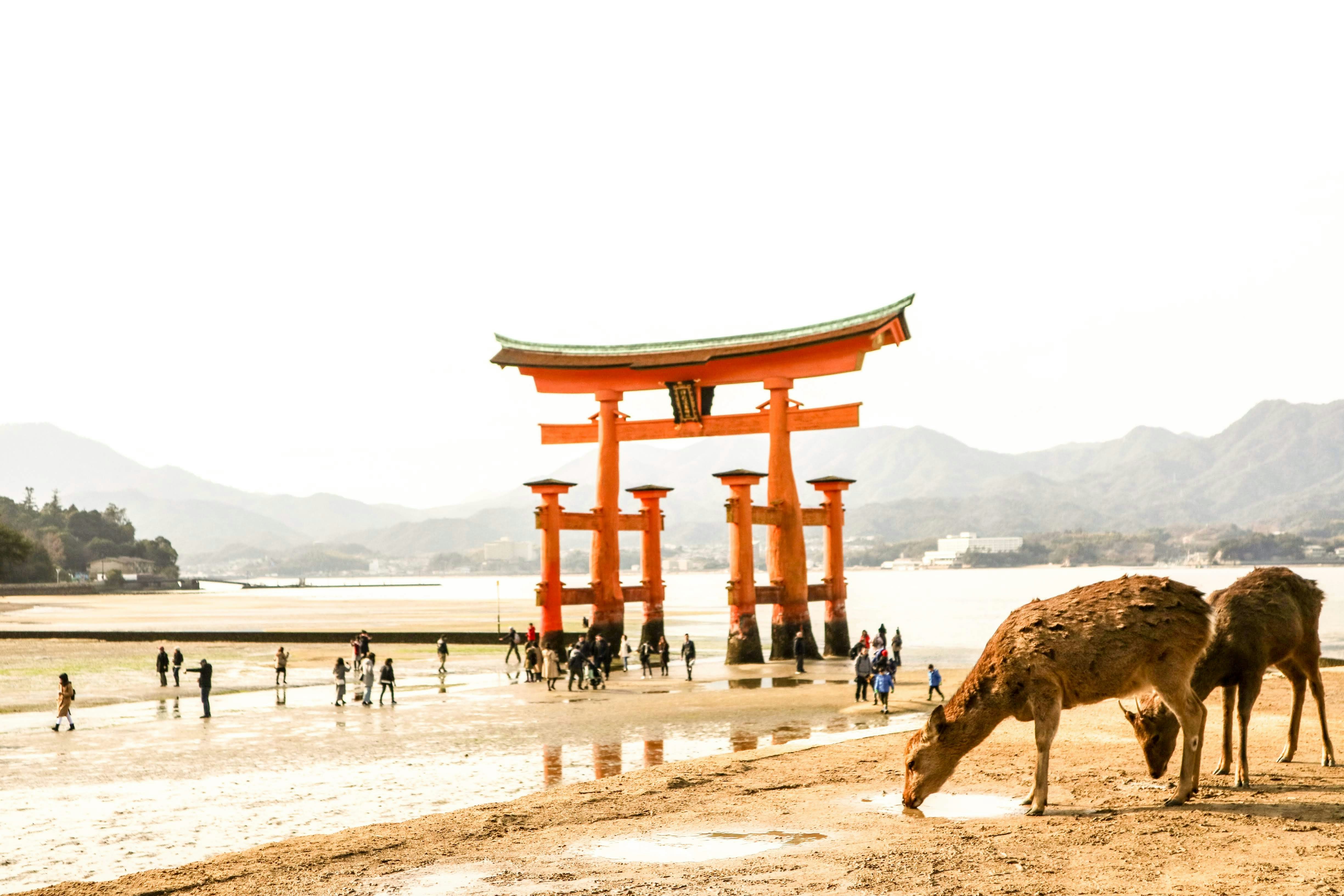
History buffs will want to write home Hiroshima. Despite being devastated in 1945, this Japanese city is known to all for its commitment peace – its ruin on the 6th August 1945 led to the end of the war and today, the Peace Memorial (a UNESCO World Heritage Site) , is a constant reminder of the destruction that war brings. A walk in the leafy boulevards of Peace Memorial Park brings quiet contemplation. The Flames of Peace – set in the park’s central feature pond – burn brightly and will continue to do so until all the nuclear bombs I the world have been destroyed. There are many other inspiring messages of hope around the city too; the Children’s’ Peace Monument just north of the park is a homage to little Sadako Sasaki, who was just two in 1945. When she developed leukemia in 1956, she believed that if she folded 1,000 paper cranes – a symbol of longevity and happiness in Japan – she would recover. Sadly she died before she finished her task but her classmates finished the rest. It is impossible to ignore the events of 1945 in Hiroshima, but this is far from a depressing place. The great efforts that have been made in rebuilding of the city over the years have given Hiroshima a vibrant, eclectic edge, with the downtown shopping area and street food stalls being well worth a visit. The proximity to Miyajima and its iconic, impressive, Torii gate should not be overlooked either. If you are lucky enough to visit during the unpredictable and short-lived Sakura (cherry blossom) season, then the extraordinary sight of the delicate pink blossom floating across the water to the red gate, means you can consider yourself one of the luckiest people on the planet.


About Beppu, Kyushu Island, Oita
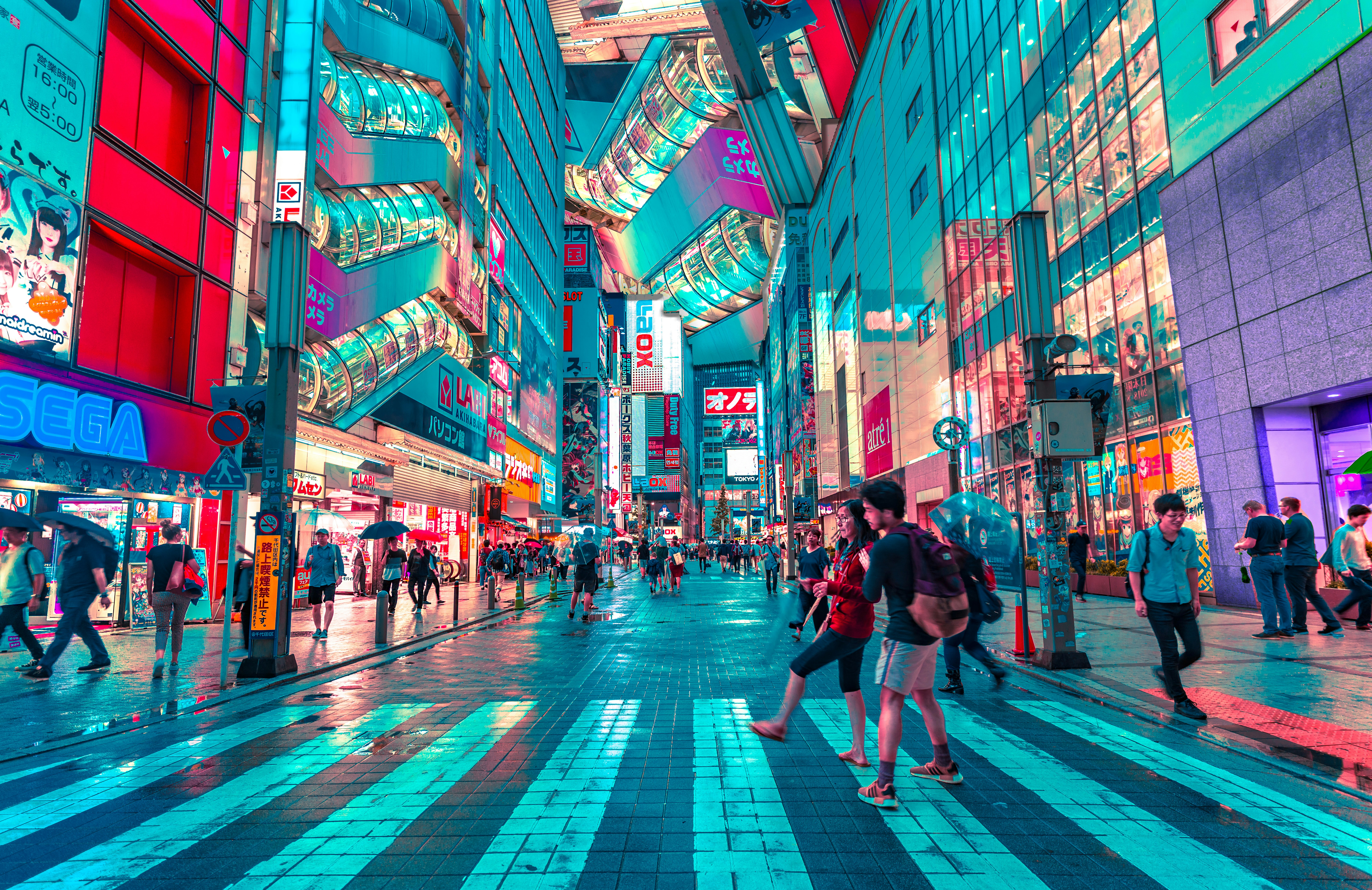
About Tokyo
Lights, sushi, manga! Sprawling, frenetic, and endlessly fascinating, Japan’s capital is a city of contrasts. Shrines and gardens are pockets of calm between famously crowded streets and soaring office buildings. Mom-and-pop noodle houses share street space with Western-style chain restaurants and exquisite fine dining. Shopping yields lovely folk arts as well as the newest electronics. And nightlife kicks off with karaoke or sake and continues with techno clubs and more. Whether you seek the traditional or the cutting edge, Tokyo will provide it.


Where You'll Go


