
Rio de Janeiro to Cape Town
Rio de Janeiro to Cape Town
Cruise overview
WHY BOOK WITH US?
- ✔ The Deluxe Cruises’ team has extensive experience in ultra-luxury cruising.
- ✔ Call now to speak to our helpful and experienced Cruise Concierge team.
- ✔ Enjoy our Unique Deluxe Cruises Bonus for substantial savings.
- ✔ Our team will tailor your holiday to your exacting requirements.
- ✔ As agents, we work under the protection of each cruise lines ABTA / ATOL licences
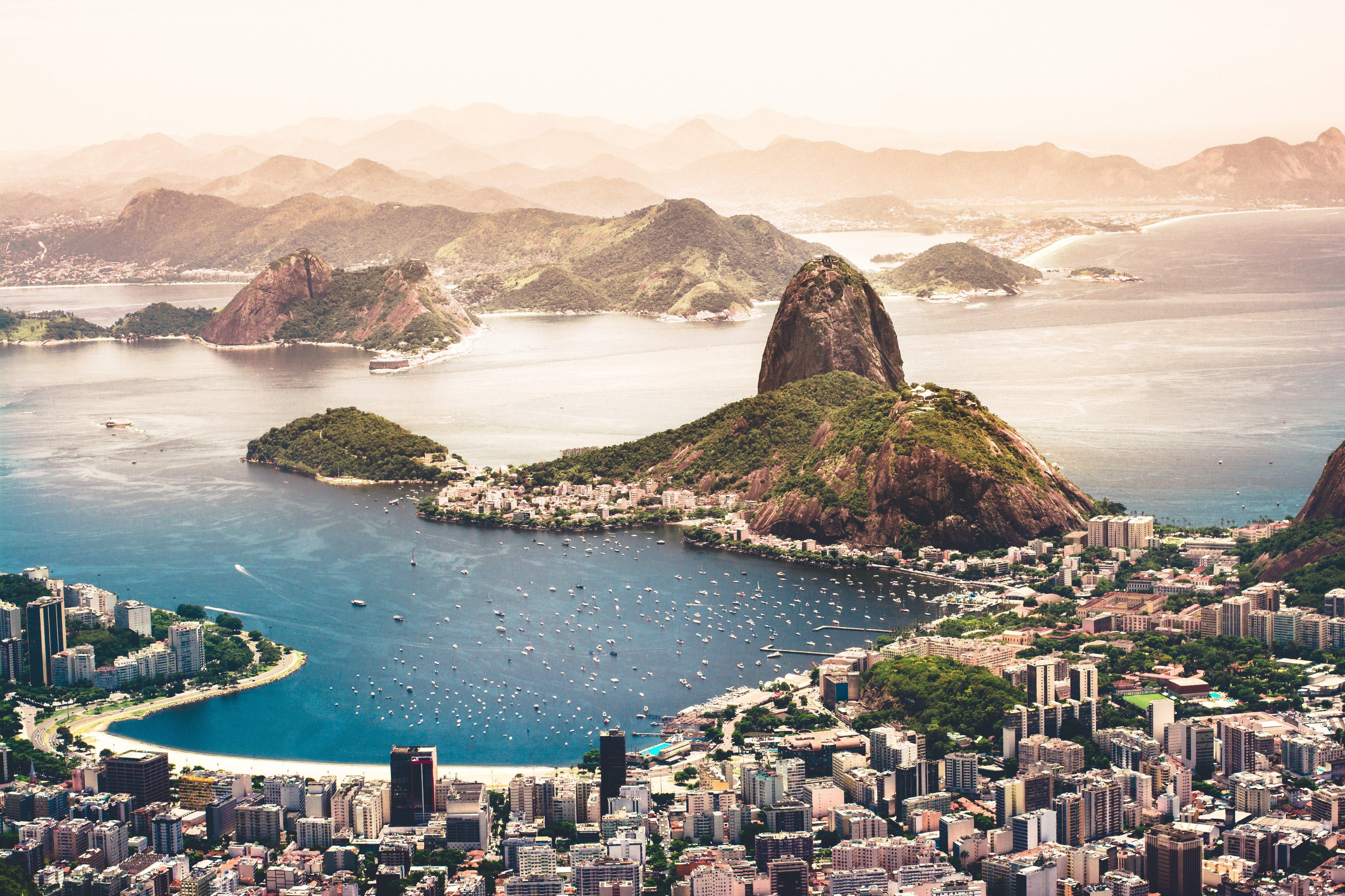
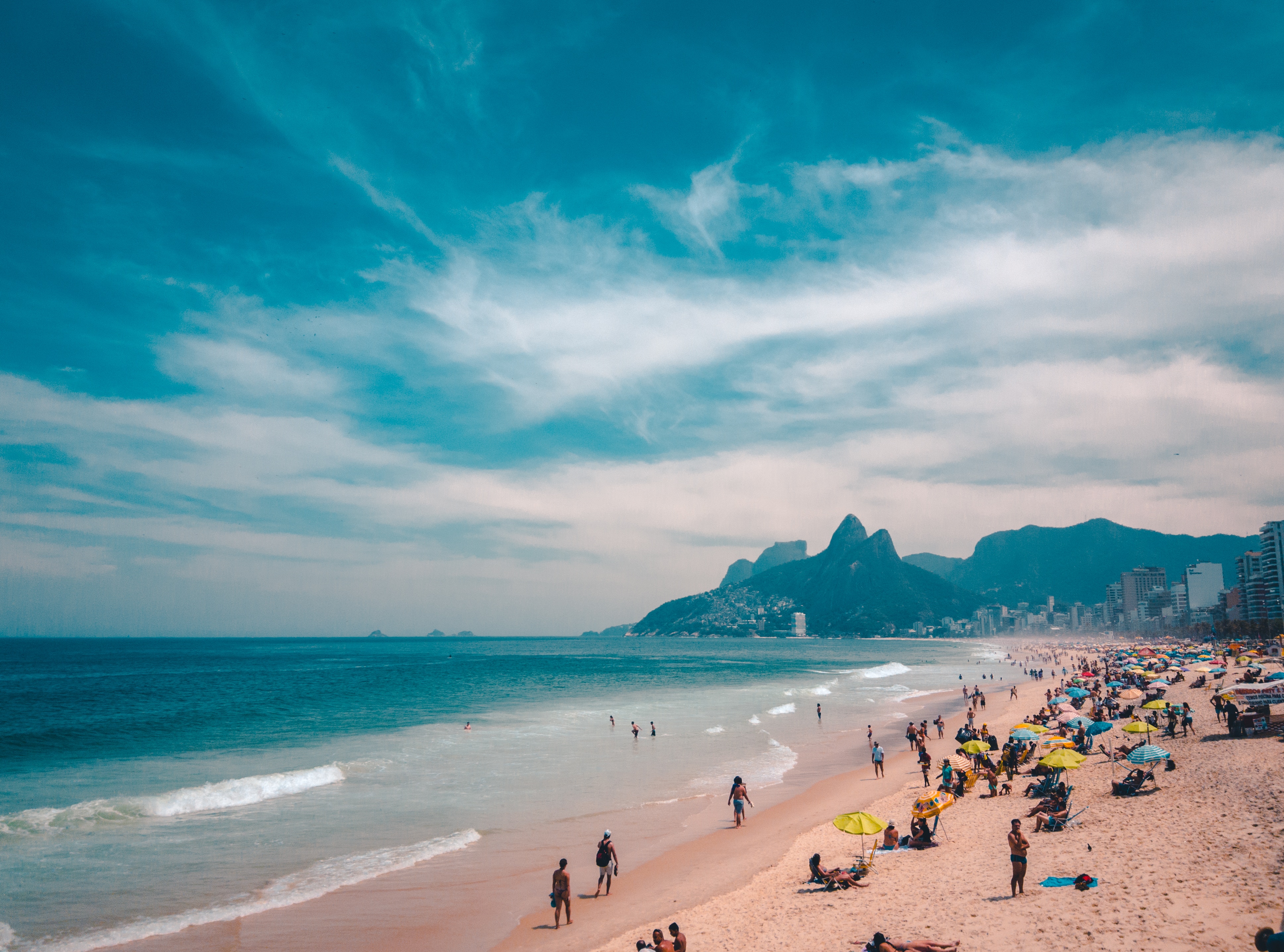
About Rio de Janeiro
Welcome to the Cidade Maravilhosa, or the Marvelous City, as Rio is known in Brazil. Synonymous with the girl from Ipanema, the dramatic views from Christ the Redeemer atop Corcovado mountain, and fabulously flamboyant Carnival celebrations, Rio is a city of stunning architecture, abundant museums, and marvelous food. Rio is also home to 23 beaches, an almost continuous 73-km (45-mile) ribbon of sand.As you leave the airport and head to Rio's beautiful Zona Sul (the touristic South Zone), you'll drive for about 40 minutes on a highway from where you'll begin to get a sense of the dramatic contrast between beautiful landscape and devastating poverty. In this teeming metropolis of 12 million people (6.2 million of whom live in Rio proper), the very rich and the very poor live in uneasy proximity. You'll drive past seemingly endless cinder-block favela, but by the time you reach Copacabana's breezy, sunny Avenida Atlântica—flanked on one side by white beach and azure sea and on the other by condominiums and hotels—your heart will leap with expectation as you begin to recognize the postcard-famous sights. Now you're truly in Rio, where cariocas (Rio residents) and tourists live life to its fullest.Enthusiasm is contagious in Rio. Prepare to have your senses engaged and your inhibitions untied. Rio seduces with a host of images: the joyous bustle of vendors at Sunday's Feira Hippie (Hippie Fair); the tipsy babble at sidewalk cafés as patrons sip their last glass of icy beer under the stars; the blanket of lights beneath the Pão de Açúcar (Sugarloaf Mountain); the bikers, joggers, strollers, and power walkers who parade along the beach each morning. Borrow the carioca spirit for your stay; you may find yourself reluctant to give it back.
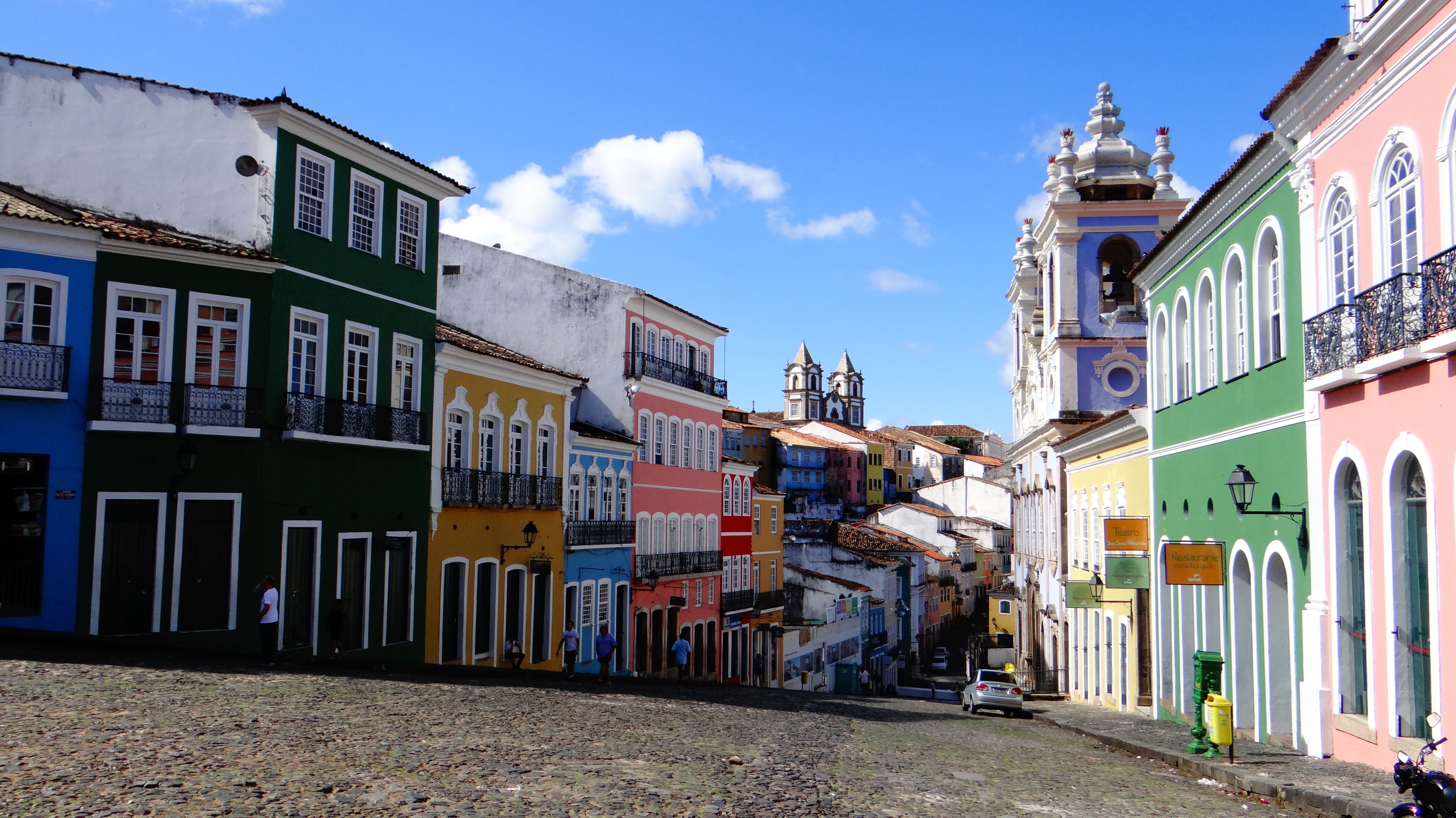
About Salvador de Bahia
According to Salvador's adopted son Jorge Amado, "In Salvador, magic becomes part of the every-day." From the shimmering golden light of sunset over the Baía do Todos os Santos, to the rhythmic beats that race along the streets, Salvador, while no longer Brazil's capital, remains one of its most captivating cities. A large dose of its exoticism comes down to its African heritage—at least 70% of its 2,675,000 population is classified as Afro-Brazilian—and how it has blended into Brazil's different strands, from the native Indians to the Christian colonizers. Salvadorans may tell you that you can visit a different church every day of the year, which is almost true—the city has about 300. Churches whose interiors are covered with gold leaf were financed by the riches of the Portuguese colonial era, when slaves masked their traditional religious beliefs under a thin Catholic veneer. And partly thanks to modern-day acceptance of those beliefs, Salvador has become the fount of Candomblé, a religion based on personal dialogue with the orixás, a family of African deities closely linked to nature and the Catholic saints. The influence of Salvador's African heritage on Brazilian music has also turned the city into one of the musical capitals of Brazil, resulting in a myriad of venues to enjoy live music across the city, along with international acclaim for exponents like Gilberto Gil, Caetano Veloso, and Daniela Mercury. Salvador's economy today is focused on telecommunications and tourism. The still-prevalent African culture draws many tourists—this is the best place in Brazil to hear African music, learn or watch African dance, and see capoeira, a martial art developed by slaves. In the district of Pelourinho, many colorful 18th- and 19th-century houses remain, part of the reason why this is the center of the tourist trade. Salvador sprawls across a peninsula surrounded by the Baía de Todos os Santos on one side and the Atlantic Ocean on the other. The city has about 50 km (31 miles) of coastline. The original city, referred to as the Centro Histórica (Historical Center), is divided into the Cidade Alta (Upper City), also called Pelourinho, and Cidade Baixa (Lower City). The Cidade Baixa is a commercial area—known as Comércio—that runs along the port and is the site of Salvador's indoor market, Mercado Modelo. You can move between the upper and lower cities on foot, via the landmark Elevador Lacerda, behind the market, or on the Plano Inclinado, a funicular lift, which connects Rua Guindaste dos Padres on Comércio with the alley behind Cathedral Basílica. From the Cidade Histórica you can travel north along the bay to the hilltop Igreja de Nosso Senhor do Bonfim. You can also head south to the point, guarded by the Forte Santo Antônio da Barra, where the bay waters meet those of the Atlantic. This area on Salvador's southern tip is home to the trendy neighborhoods of Barra, Ondina, and Rio Vermelho, with many museums, theaters, shops, and restaurants. Beaches along the Atlantic coast and north of Forte Santo Antônio da Barra are among the city's cleanest. Many are illuminated at night and have bars and restaurants that stay open late.

About Saint Helena
St Helena is a tiny, remote island lying in the South Atlantic, and thanks to its isolation it has a rare and unspoilt beauty. The nearest land is Ascension Island, situated some 700 miles north-west of St Helena, and the nearest mainland, West Africa, is over 1,000 miles away. The island was discovered by Juan de Nova Castella on May 21, 1502 and subsequently became a stop-off point for Portuguese vessels to replenish their supplies and break long voyages. In 1676 the famous astonomer Edmund Haley arrived in St Helena to produce his 'Catalogue of the Stars in the Southern Hemisphere'. However, the island is perhaps best known as the final exile of Napoleon Bonaparte. Following his defeat at Waterloo in 1815, Napoleon was exiled to Longwood House where he remained until his death six years later in 1821.
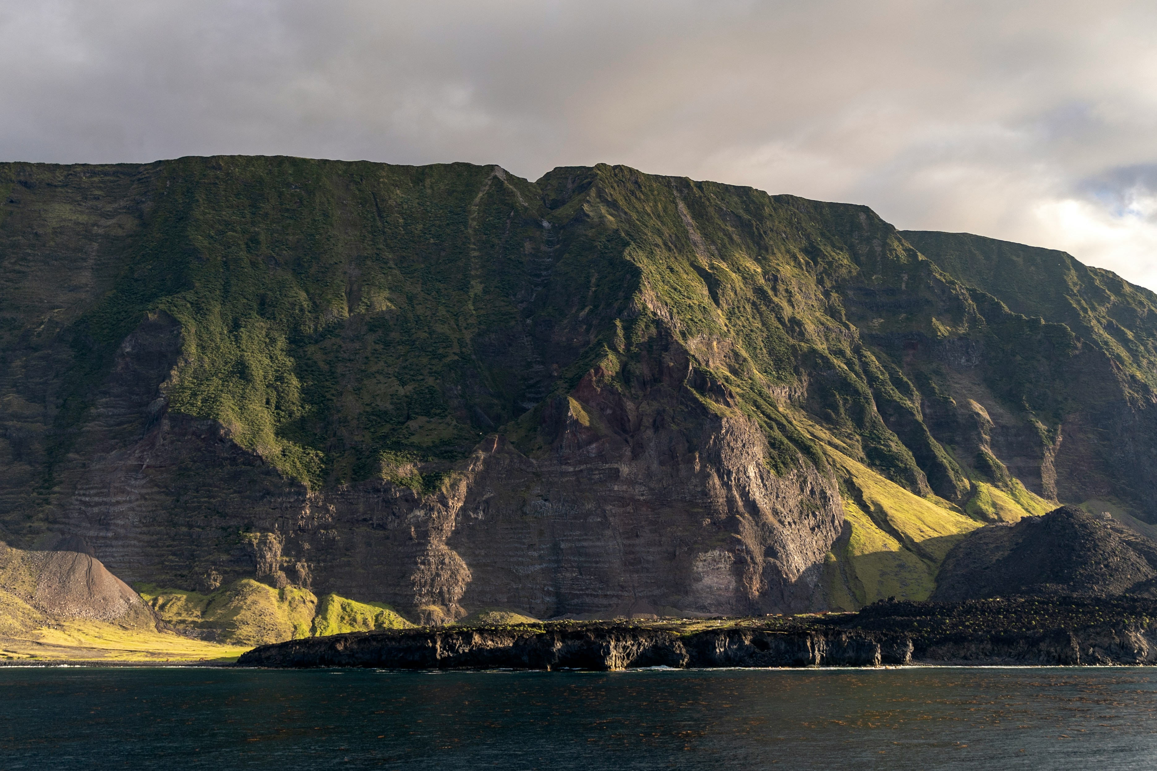
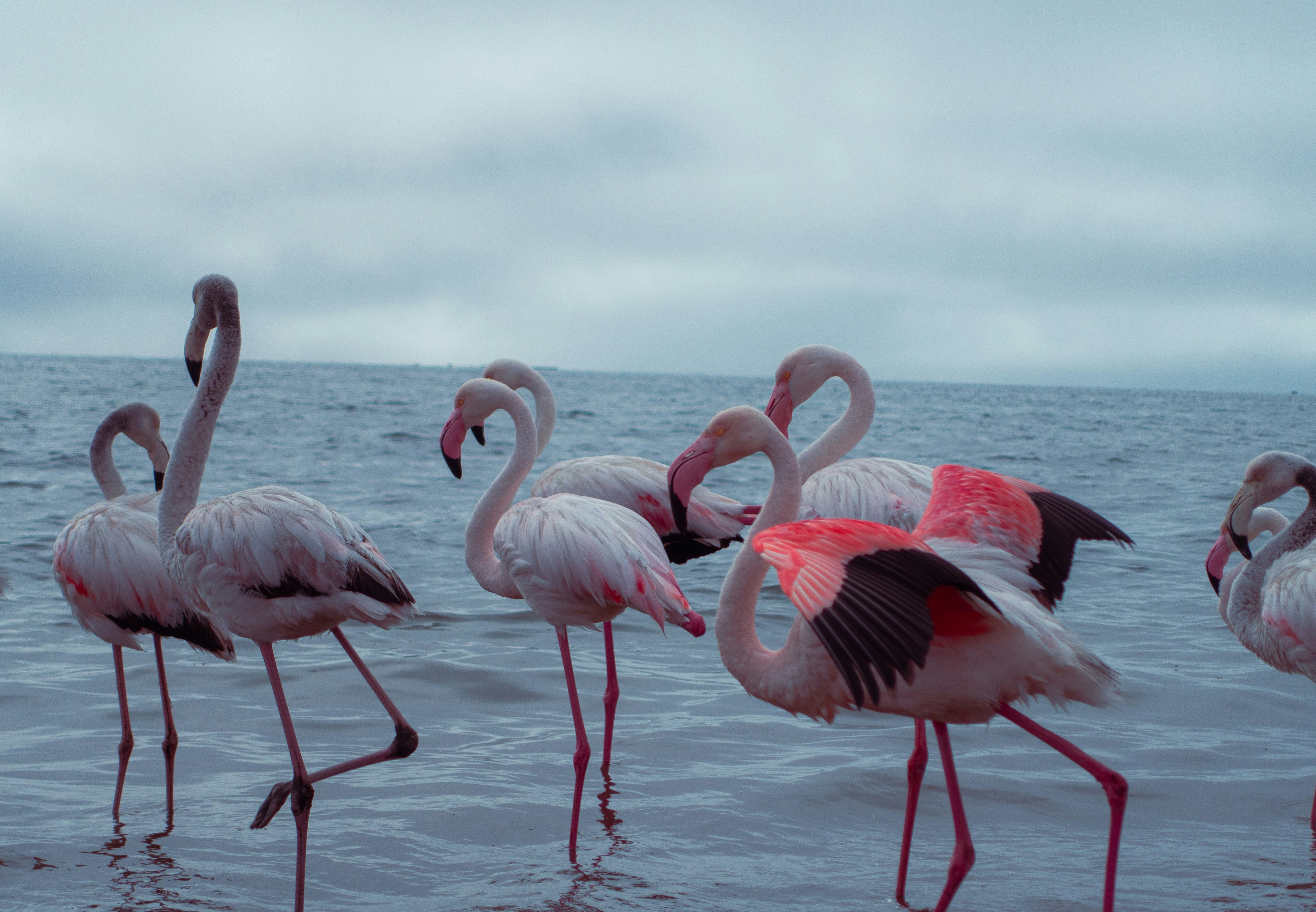
About Walvis Bay
Once a whaling station, Walvis Bay provides a gateway to the extraordinary desert landscapes of Namibia and is itself an area of unusual natural beauty. The showpiece of the Walvis Bay area is the natural lagoon where you can see flamingos in their thousands at certain times of the year, along with a variety of other wading birds such as the white pelican. Further inland you will find the stunning Namib Desert, which provides an unlikely home for a diverse array of wildlife. Alternatively, you could venture into the desert of Sossusvlei, whose mountainous ochre sand dunes are said to be the highest in the world, or visit the colonial town of Swakopmund.
About Lüderitz
The reopening of the diamond mine at Elizabeth Bay 20 years ago has brought the development of tourism and fishing back to this small 19th century village on the barren, windswept Namib Desert coast. One of Namibias oddities, it has everything you'd expect from a small German town - delicatessens, coffee shops and a Lutheran church. Here, the icy but clean South Atlantic is home to seals, penguins and other marine life and the desolate beaches support flamingoes. It was founded in 1883 when Heinrich Vogelsang purchased Angra Pequena and some of the surrounding land on behalf of Adolf Lüderitz, a Hanseat from Germany, from the local Nama chief. Lüderitz began its life as a trading post, with other activities in fishing and guano-harvesting. As a sign of Luderitz's revival, 1996 staged the first traditional German Karneval since 1960.
About Cape Town
Sometimes referred to as the Mother City, Cape Town is the most famous port in South Africa and is influenced by many different cultures, including Dutch, British and Malay. The port was founded in 1652 by Dutch explorer Jan Van Riebeeck, and evidence of Dutch colonial rule remains throughout the region. The port is located on one of the world's most important trade routes, and is mainly a container port and handler of fresh fruit. Fishing is another vital industry, with large Asian fishing fleets using Cape Town as a logistical repair base for much of the year. The region is famous for its natural beauty, with the imposing Table Mountain and Lions Head, as well as the many nature reserves and botanical gardens such as Kirstenbosch which boasts an extensive range of indigenous plant life, including proteas and ferns. Cape Town's weather is mercurial, and can change from beautiful sunshine to dramatic thunderstorms within a short period. A local adage is that in Cape Town you can experience four seasons in one day.
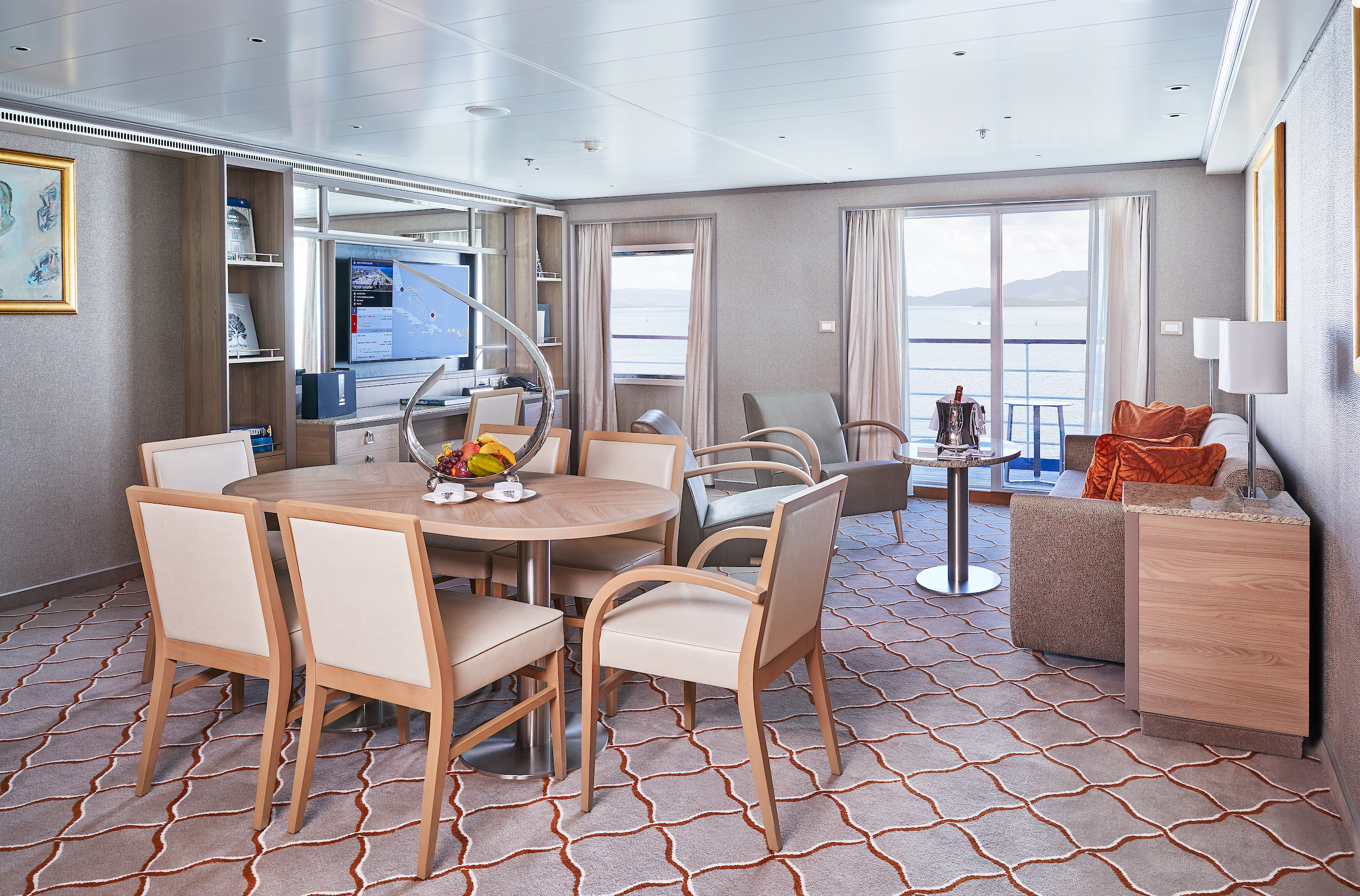
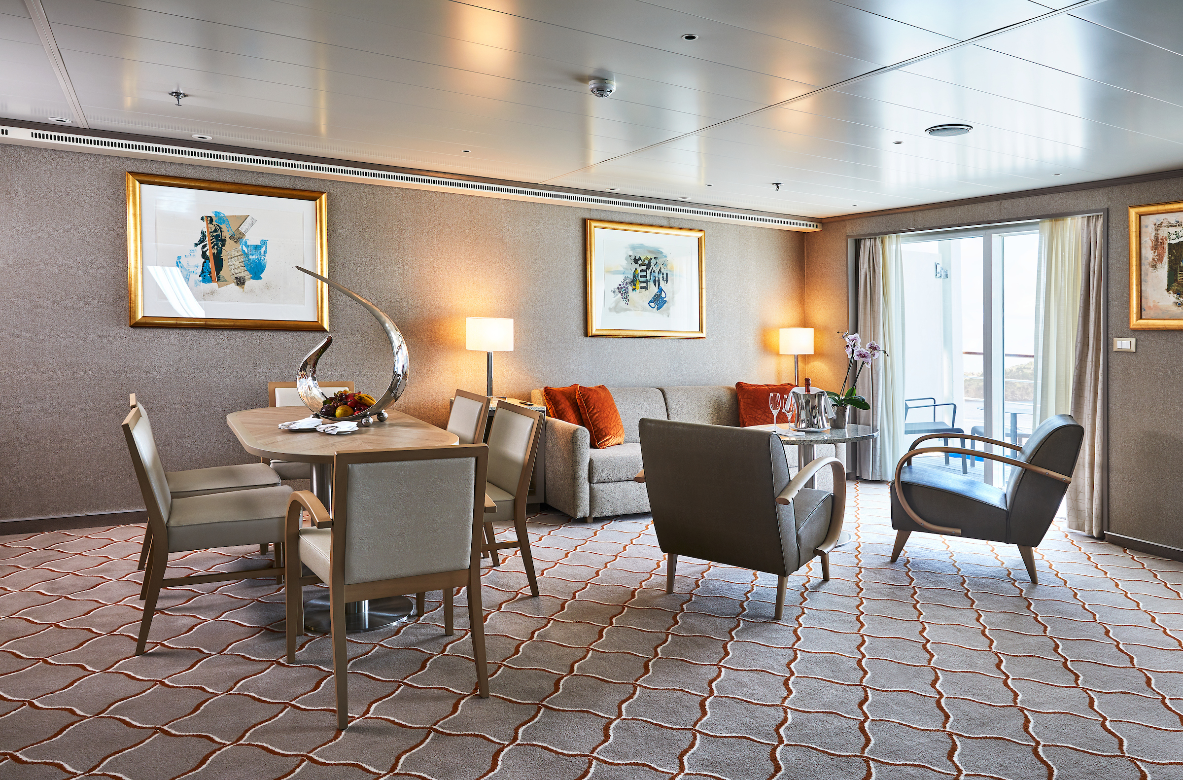
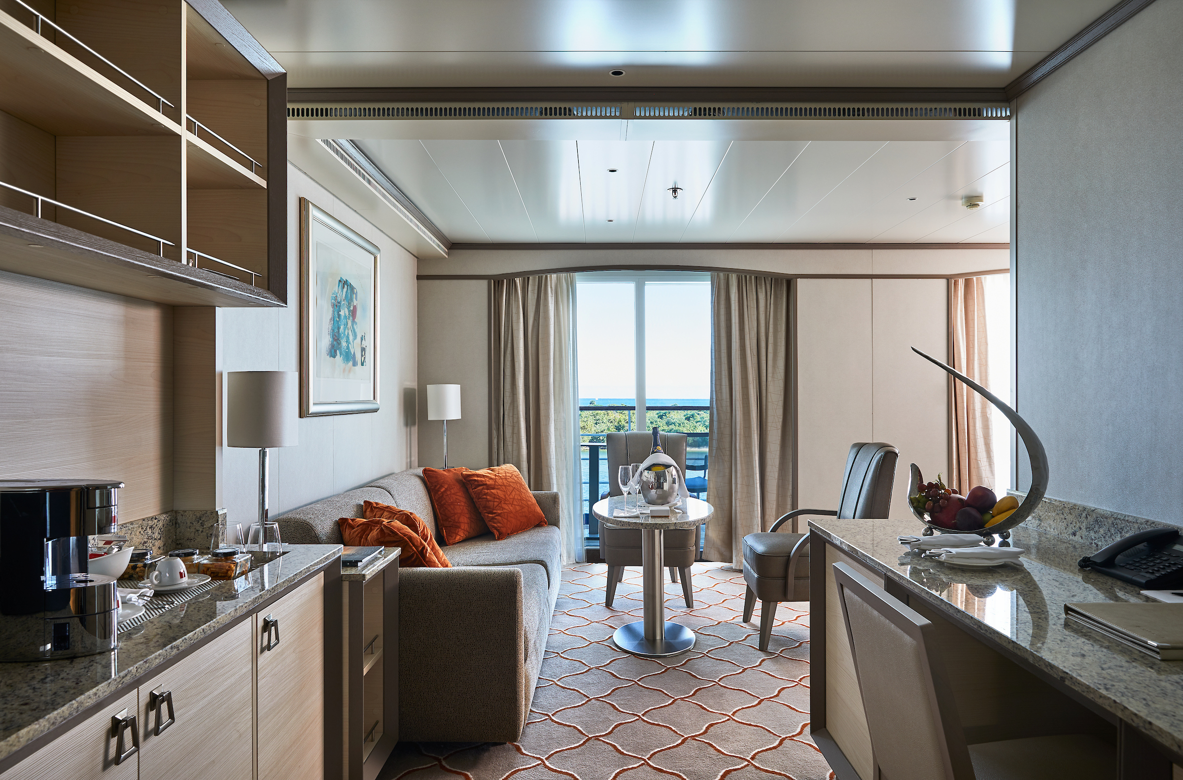
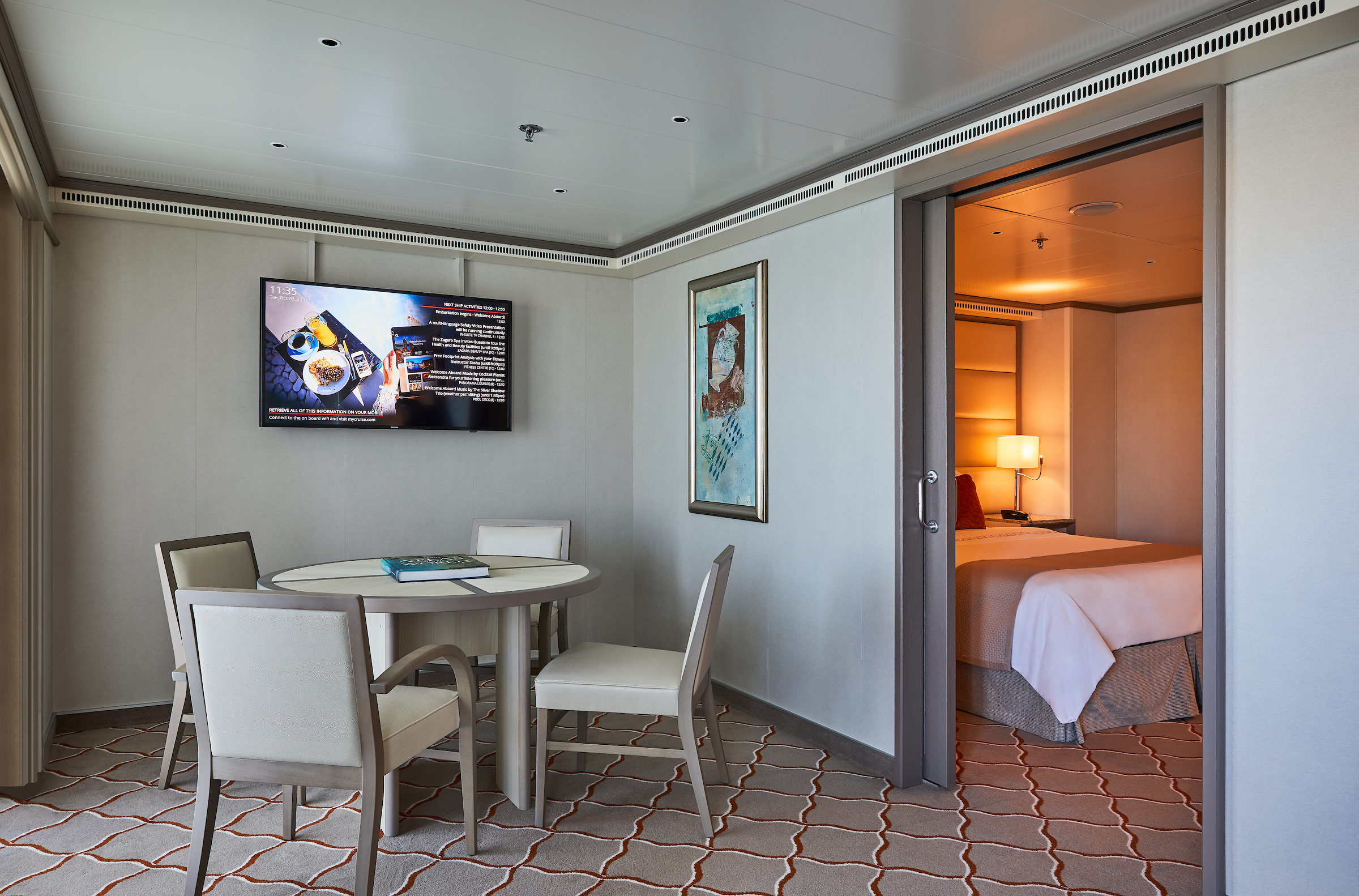
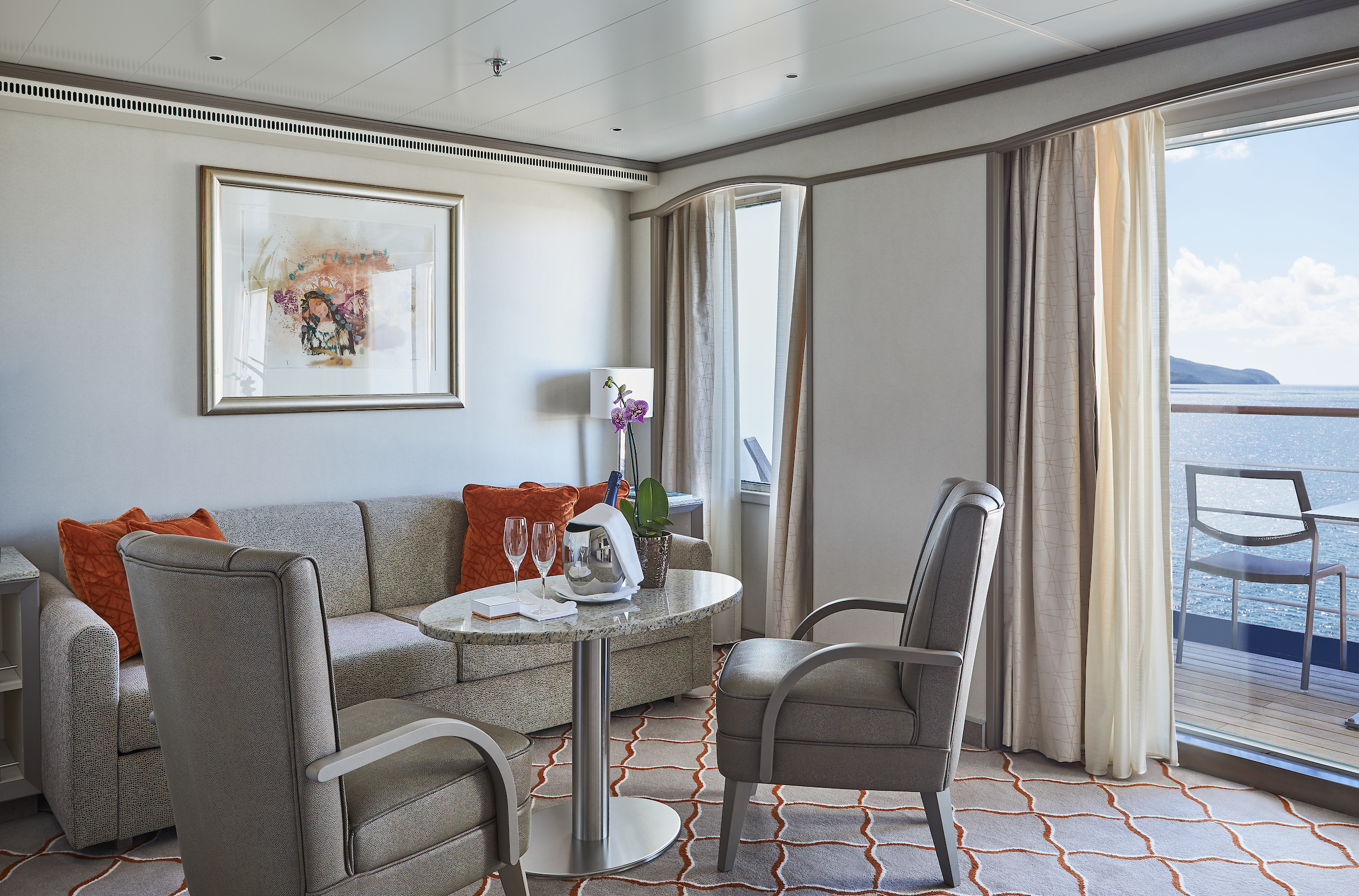
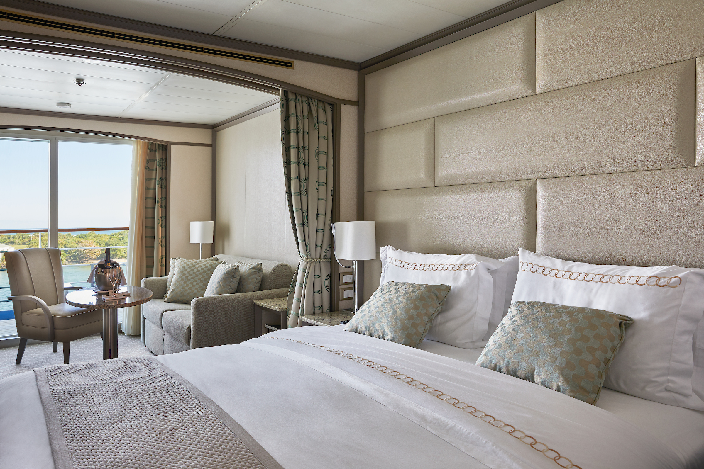
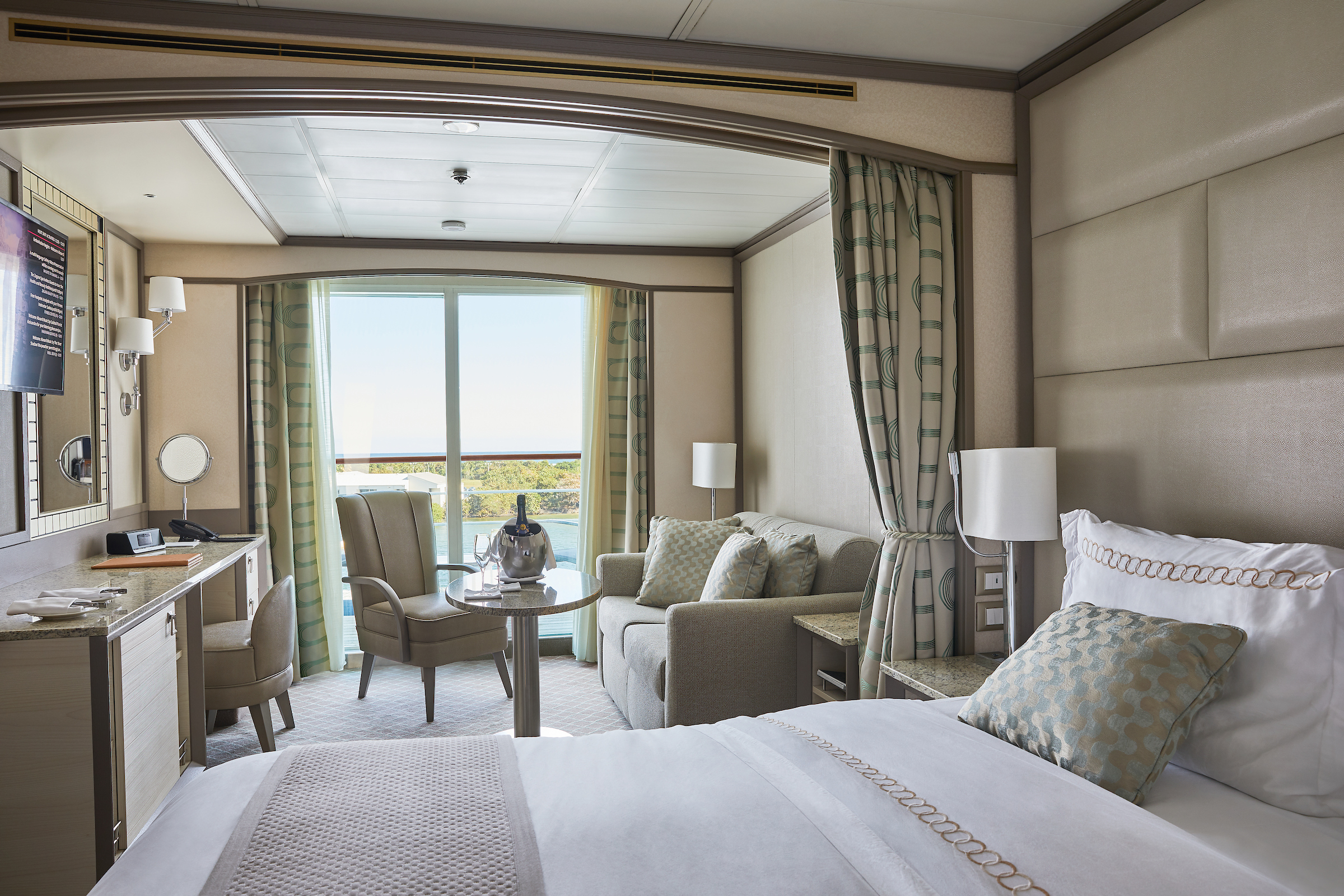
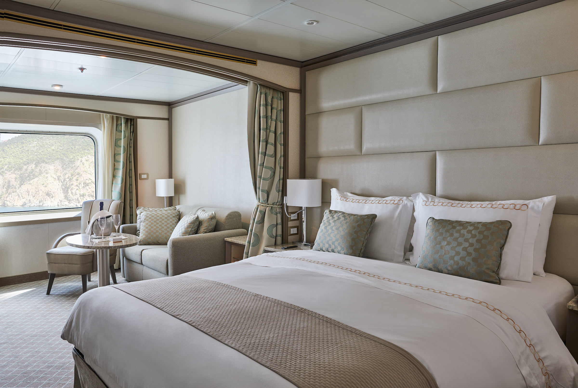
The name Owner’s Suite says it all. A stylish apartment. Prestigious and classic. For those who seek the superlative level of space, comfort, and service on board. Available in a one- or two-bedroom configuration (as illustrated) by adjoining with a Vista Suite.
One bedroom: 85 sq m including veranda (20 sq m)
Two bedrooms: 117 sq m including veranda (20 sq m)
Please note that the 3rd guest will sleep on a comfortable sofa bed in the reception area of the suite.
Essentials
- Deck(s): 7
- Section: Mid-Ship
Characteristics
- Veranda
- Separate dining area
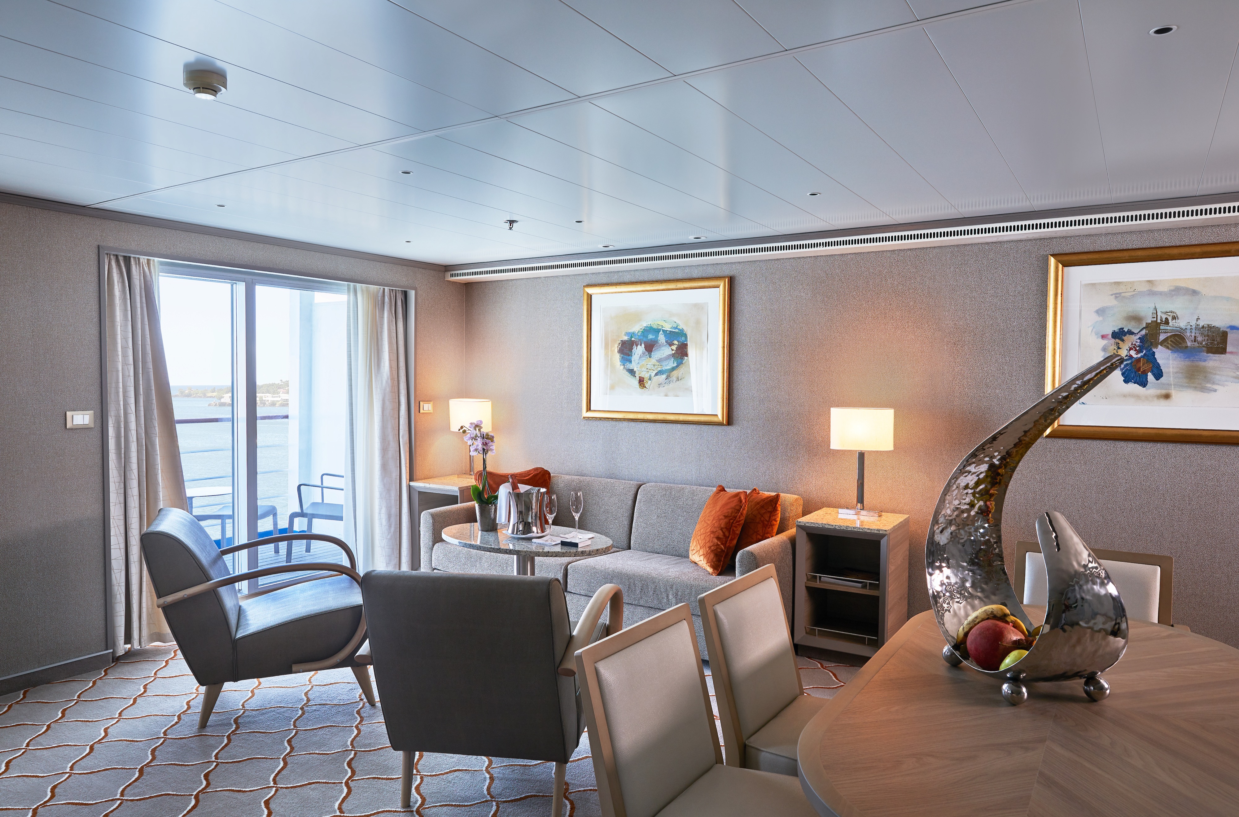
- Living room with sitting area
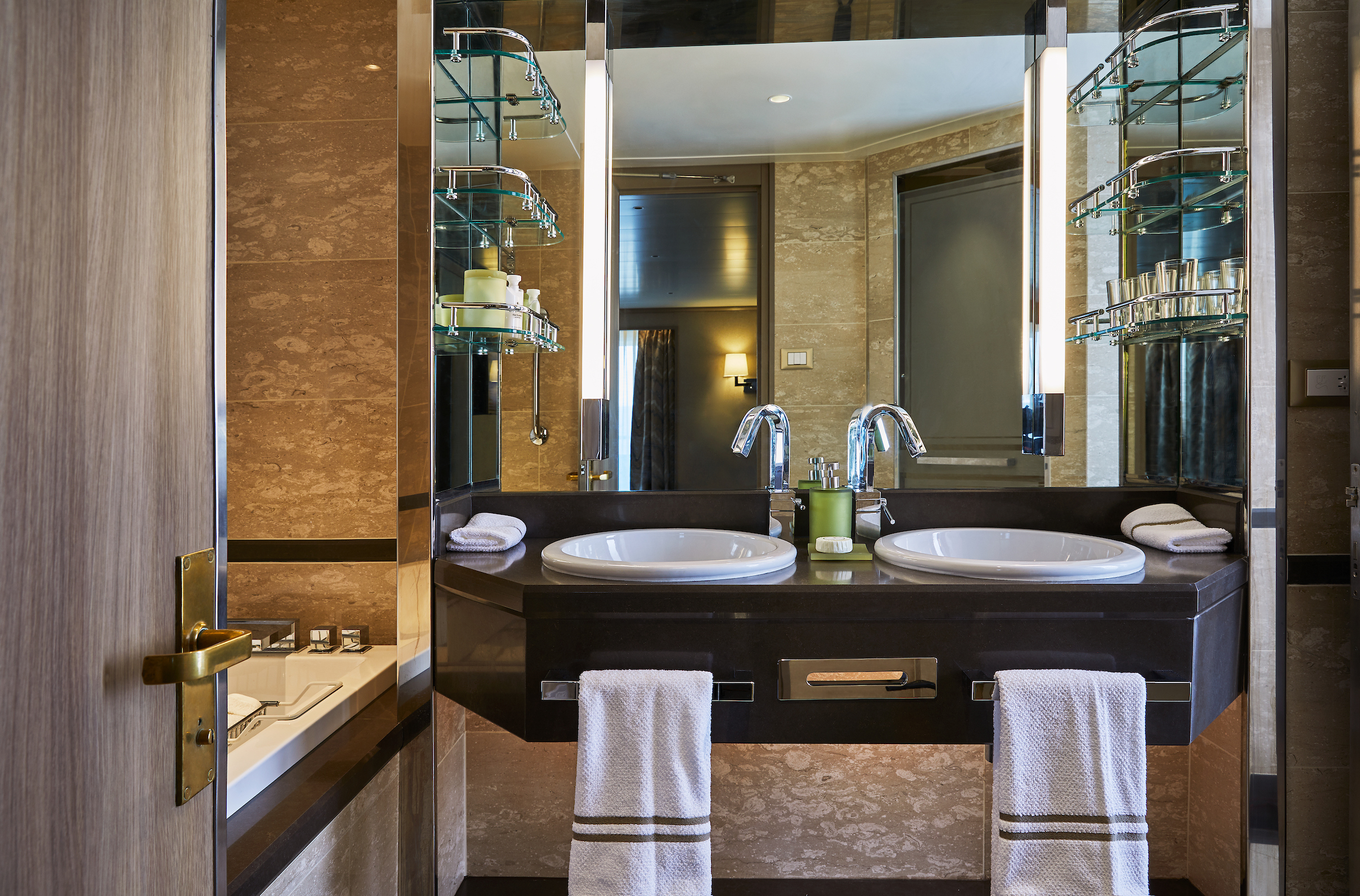
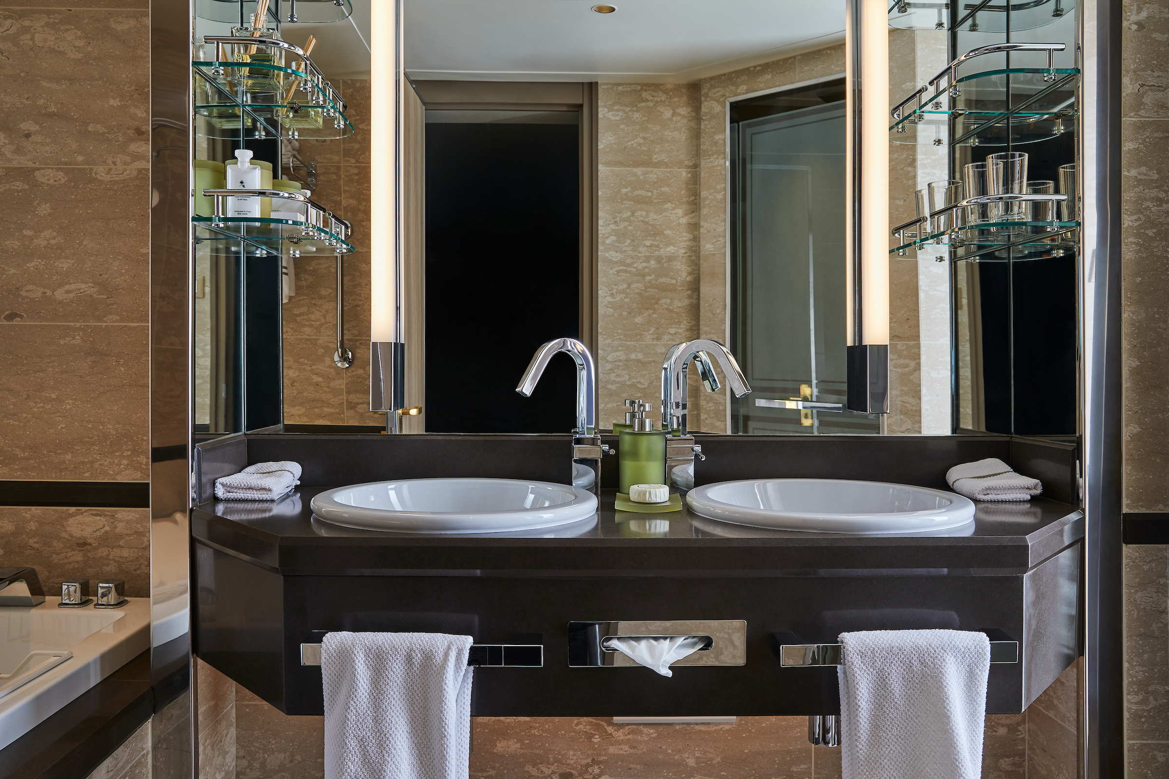
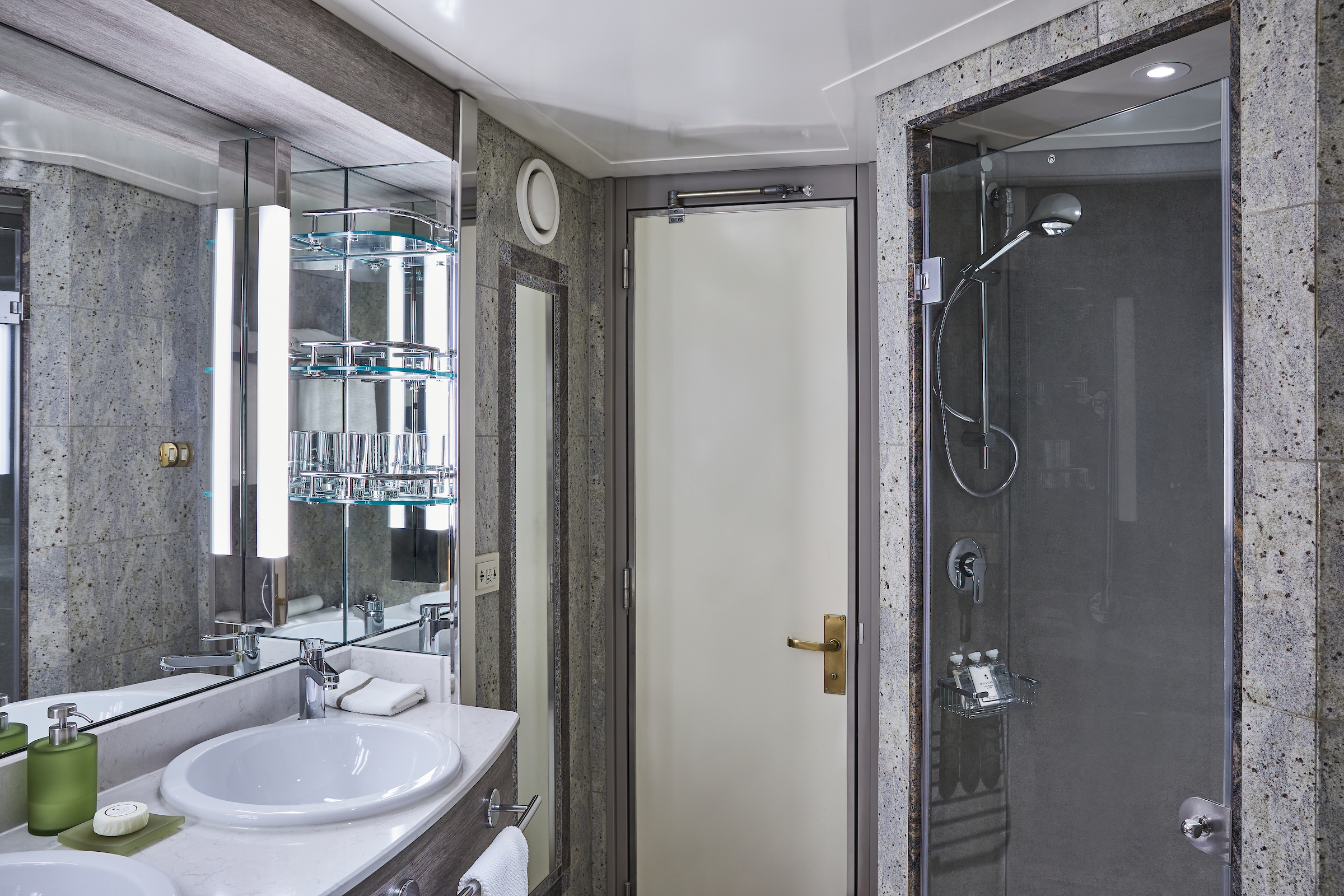
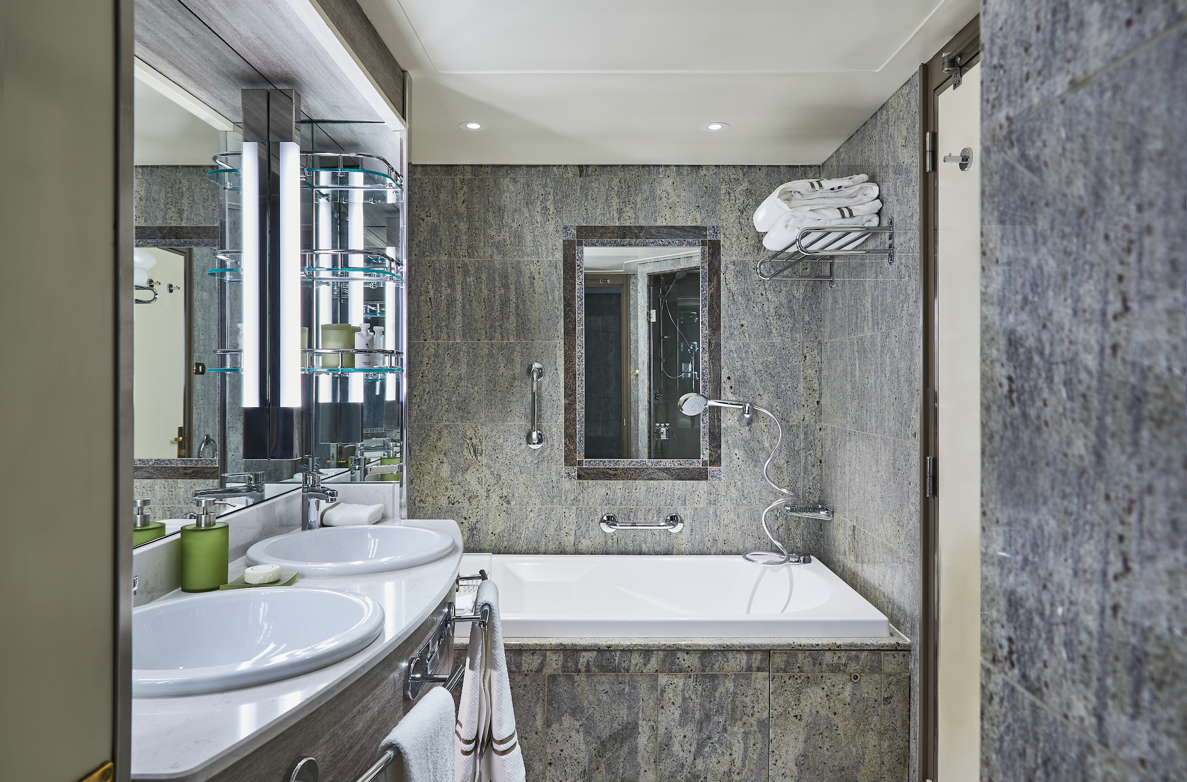
- Double vanity
- Separate shower
- Full-size bath
- Walk-in wardrobe with personal safe
Furniture
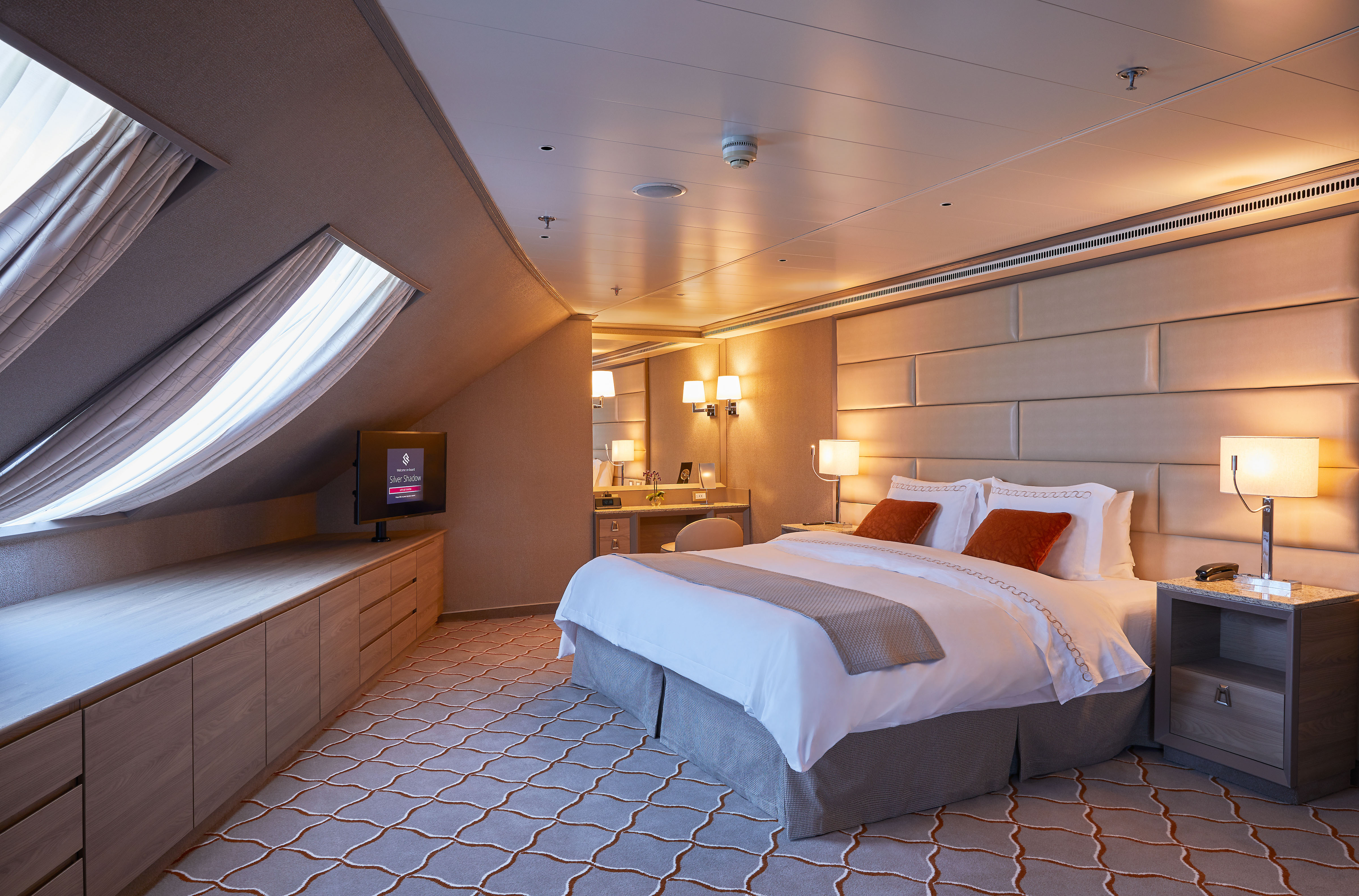
- King size bed
- Writing desk
- Vanity table
- Luxury bed mattresses
Media & Communication
- Unlimited Premium Wi-Fi
- 2 large flat screen TVs with Interactive Media Library
- Sound system with bluetooth connectivity
- Direct dial telephone
- Wall mounted USB-C mobile device chargers
- Dual voltage 110/220 outlets
Onboard Services
- Butler service
- Complimentary laundry, pressing & wet cleaning
- Dinner for two in La Dame, one evening per voyage,
- Two hours of worldwide phone use, per voyage segment
- Champagne on arrival
Amenities
- Espresso machine
- Tea kettle
- Pillow menu
- Refrigerator and bar setup stocked with your preferences
- Plush bathrobe
- Luxury bath amenities
- Umbrella
- Hair Dryer
- Slippers
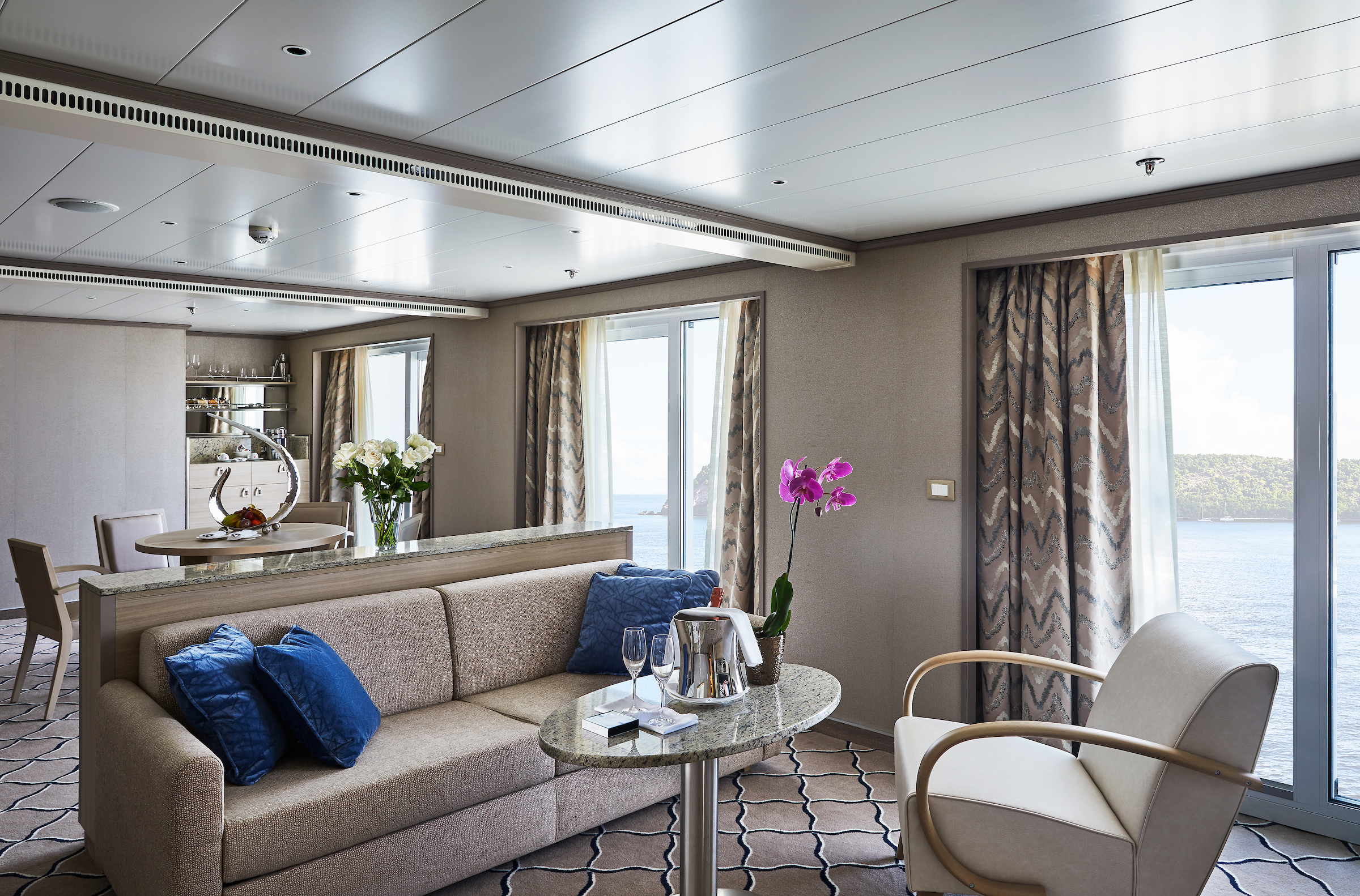
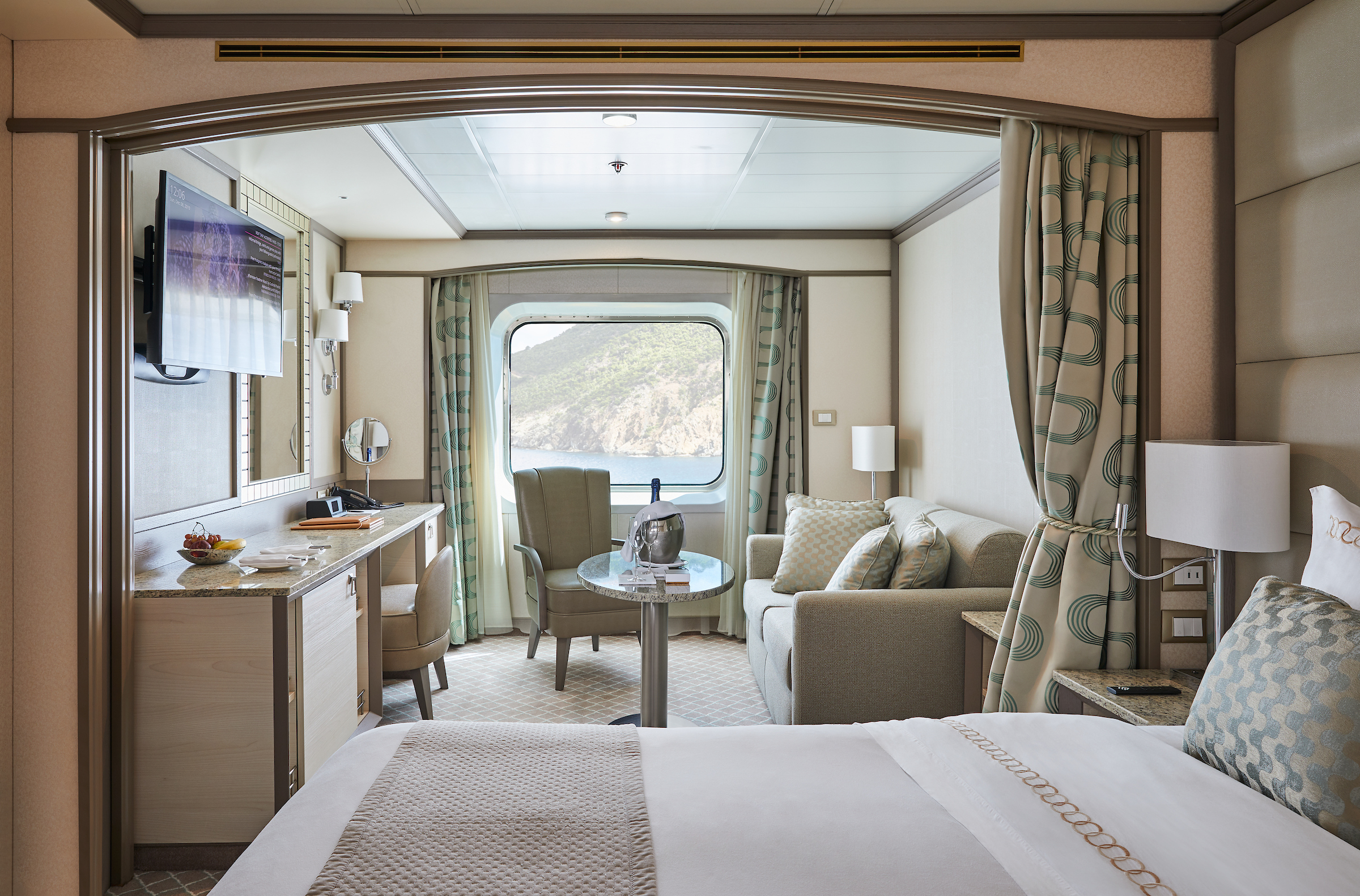
One of Silversea's finest suites, the Grand Suite's spacious amenities allows vou to cruise in comfort and class.
Expertly designed and exquisitely appointed. Ideal for entertaining friends while you cruise or enjoying a quiet dinner “at home”. Available as a one-bedroom configuration or as two-bedrooms (as illustrated) by adjoining with a Silversea Veranda Suite.
One bedroom: 87-101 sq.m. including veranda
Two bedroom: 133 sq.m. including veranda
Please note that the 3rd guest will sleep on a comfortable sofa bed in the reception area of the suite.Essentials
- Deck(s): 6, 7, 8
- Section: Forward
Characteristics
- Veranda
- Separate dining area
- Living room with sitting area
- Double vanity
- Separate shower
- Full-size bath
- Walk-in wardrobe with personal safe
Furniture
King size bed
- Writing desk
- Vanity table
- Luxury bed mattresses
Media & Communication
- Unlimited Premium Wi-Fi
- 2 large flat screen TVs with Interactive Media Library
- Sound system with bluetooth connectivity
- Direct dial telephone
- Wall mounted USB-C mobile device chargers
- Dual voltage 110/220 outlets
Onboard Services
- Butler service
- Complimentary laundry, pressing & wet cleaning
- Dinner for two in La Dame, one evening per voyage,
- Two hours of worldwide phone use, per voyage segment
- Champagne on arrival
Amenities
- Espresso machine
- Tea Kettles
- Pillow menu
- Refrigerator and bar setup stocked with your preferences
- Plush bathrobe
- Luxury bath amenities
- Umbrella
- Hair Dryer
- Slippers
Stately describes the Royal Suite. Commanding and majestic. Perfect for entertaining. Enough living space to roam. The pinnacle of good living. Available in a one- or two-bedroom configuration (as illustrated) by adjoining with a Veranda Suite.
One bedroom: 90–94 sq m including veranda (10–11 sq m)
Two bedrooms: 126 sq m including veranda (16–17 sq m)
Please note that the 3rd guest will sleep on a comfortable sofa bed in the reception area of the suite.
Essentials
- Deck(s): 6, 7
- Section: Forward
Characteristics
- Veranda
- Separate dining area
- Living room with sitting area
- Double vanity
- Separate shower
- Full-size bath
- Walk-in wardrobe with personal safe
Furniture
- King size bed
- Writing desk
- Vanity table
- Luxury bed mattresses
Media & Communication
- Unlimited Premium Wi-Fi
- 2 large flat screen TVs with Interactive Media Library
- Sound system with bluetooth connectivity
- Direct dial telephone
- Wall mounted USB-C mobile device chargers
- Dual voltage 110/220 outlets
Onboard Services
- Butler service
- Complimentary laundry, pressing & wet cleaning
- Dinner for two in La Dame, one evening per voyage,
- Two hours of worldwide phone use, per voyage segment
- Champagne on arrival
Amenities
- Espresso machine
- Tea Kettles
- Pillow menu
- Refrigerator and bar setup stocked with your preferences
- Plush bathrobe
- Luxury bath amenities
- Umbrella
- Hair Dryer
- Slippers
Stylish and sophisticated. Separate dining and living rooms. Larger verandas. Situated midship. Perfection in design for comfortable living. Silver Suites accommodate three guests.
One bedroom: 61–65 sq m including veranda (10–11 sq m)
Please note that the 3rd guest will sleep on a comfortable sofa bed in the reception area of the suite.
Essentials
- Deck(s): 7
- Section: Mid-Ship
Characteristics
- Veranda
- Separate dining area
- Living room with sitting area
- Double vanity
- Separate shower
- Full-size bath
- Walk-in wardrobe with personal safe
Furniture
- Queen size bed
- Writing desk
- Vanity table
- Luxury bed mattresses
Media & Communication
- Unlimited Premium Wi-Fi
- 2 large flat screen TVs with Interactive Media Library
- Sound system with bluetooth connectivity
- Direct dial telephone
- Wall mounted USB-C mobile device chargers
- Dual voltage 110/220 outlets
Onboard Services
- Butler service
- Complimentary laundry, pressing & wet cleaning
- Champagne on arrival
Amenities
- Espresso machine
- Tea Kettles
- Pillow menu
- Refrigerator and bar setup stocked with your preferences
- Plush bathrobe
- Luxury bath amenities
- Umbrella
- Hair Dryer
- Slippers
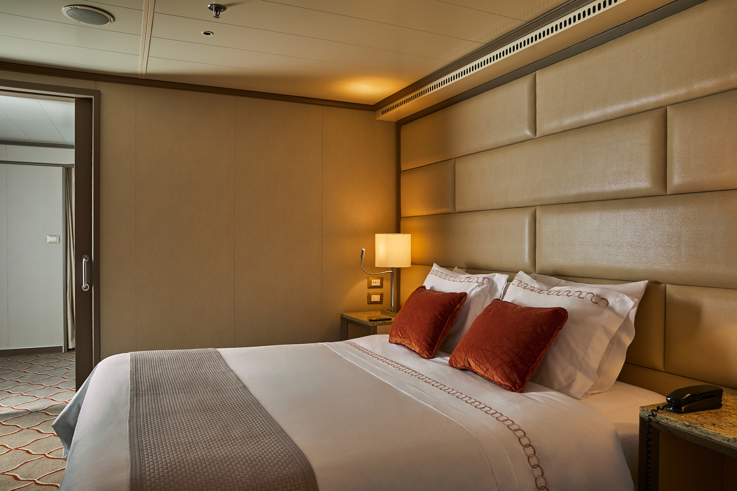
A mark of distinction. Sumptuous. Spacious. Rich textures and panoramic views surround you with distinguished luxury. An extravagant suite for an extravagant cruise.
One bedroom: 49 sq m including veranda (8 sq ft)
Please note that the 3rd guest will sleep on a comfortable sofa bed in the reception area of the suite.
Essentials
- Deck(s): 7
- Section: Mid-Ship
Characteristics
- Veranda
- Living room with sitting area
- Double vanity
- Separate shower
- Full-size bath
- Walk-in wardrobe with personal safe
Furniture
- Queen size bed
- Writing desk
- Vanity table
- Luxury bed mattresses
Media & Communication
- Unlimited Premium Wi-Fi
- 2 large flat screen TVs with Interactive Media Library
- Sound system with bluetooth connectivity
- Direct dial telephone
- Wall mounted USB-C mobile device chargers
- Dual voltage 110/220 outlets
Onboard Services
- Butler service
- Complimentary laundry, pressing & wet cleaning
- Dinner at the officer’s table
- Champagne on arrival
Amenities
- Espresso machine
- Tea Kettle
- Pillow menu
- Refrigerator and bar setup stocked with your preferences
- Plush bathrobe
- Luxury bath amenities
- Umbrella
- Hair Dryer
- Slippers
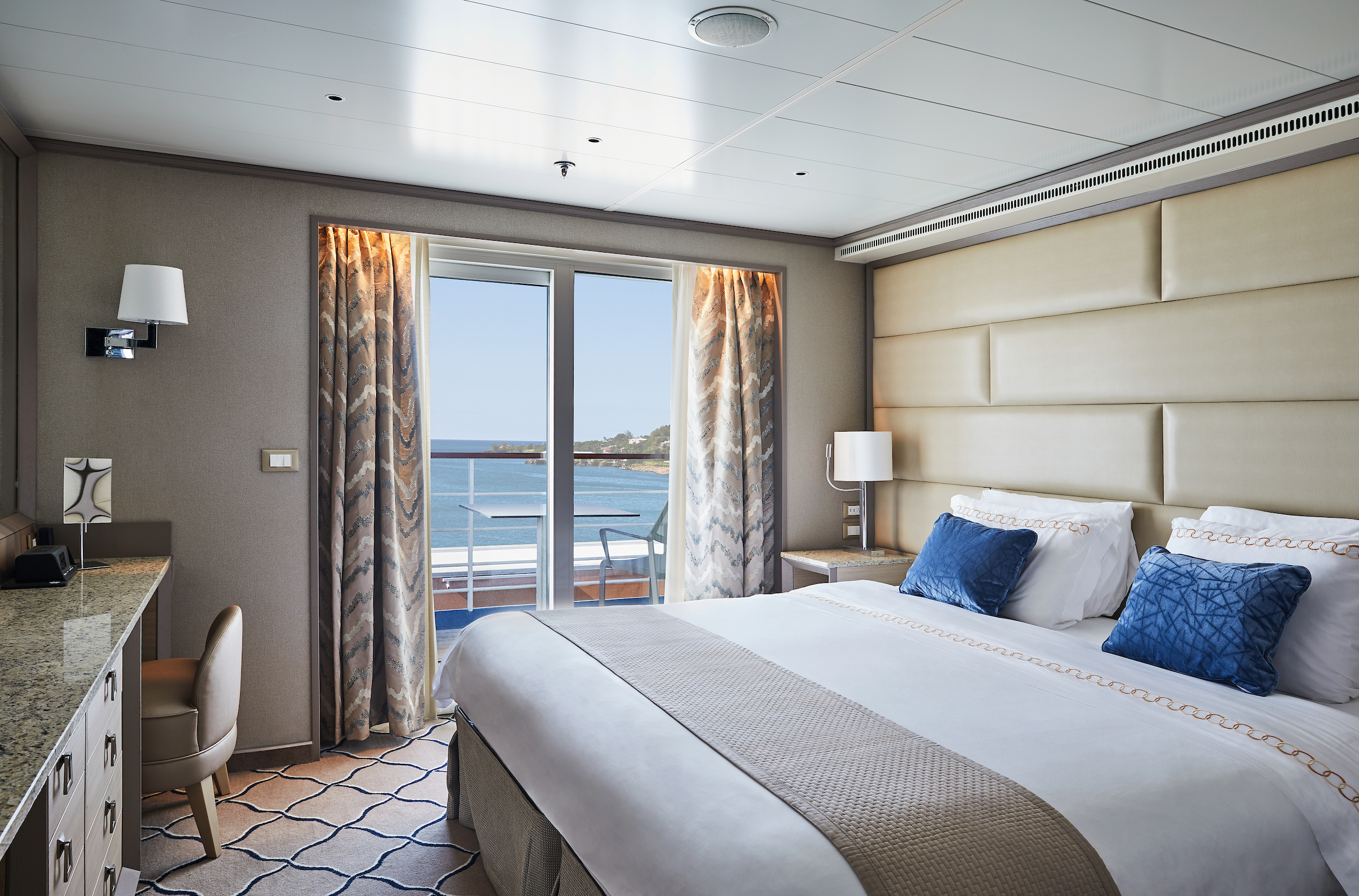
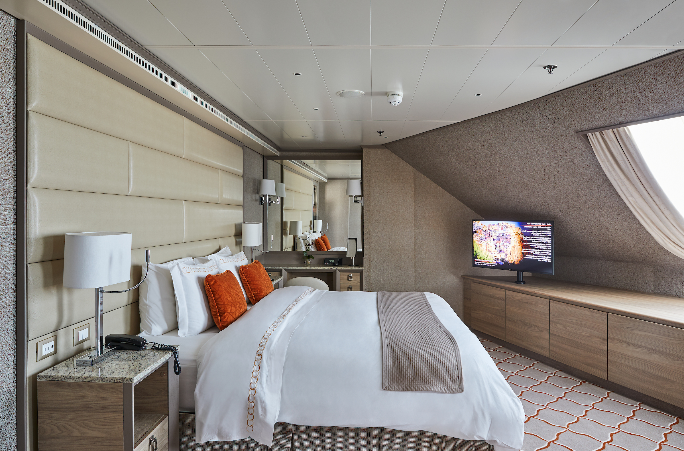
The Deluxe Veranda Suite offers a comfortable living space, close to the heart of the ship. With its preferred midship location and all the comfort and attention to detail that you can expect aboard, the Deluxe Veranda Suite is the savvy traveler’s paradise—both inside and out. Elegant decor, a stunning marble bathroom, and an ample seating area make this a cozy home away from home. But perhaps this suite’s finest asset lies just outside, as floor-to-ceiling glass doors open onto a private veranda, making every sunset feel as if it is yours alone.
One bedroom: 32 sq m including veranda (6 sq m)
Please note that the 3rd guest will sleep on a comfortable sofa bed in the reception area of the suite.
Essentials
- Deck(s): 6, 8, 9
- Section: Forward, Mid-Ship
Characteristics
- Veranda
- Sitting area
- Double vanity
- Separate shower
- Full-size bath
- Walk-in wardrobe with personal safe
Furniture
- Queen size bed
- Writing desk
- Vanity table
- Luxury bed mattresses
Media & Communication
- Unlimited Standard Wi-Fi
- 1 large flat screen TV with Interactive Media Library
- Direct dial telephone
- Wall mounted USB-C mobile device chargers
- Dual voltage 110/220 outlets
Onboard Services
- Butler service
- Champagne on arrival
Amenities
- Pillow menu
- Espresso machine
- Tea Kettles
- Refrigerator and bar setup stocked with your preferences
- Plush bathrobe
- Luxury bath amenities
- Umbrella
- Hair Dryer
- Slippers
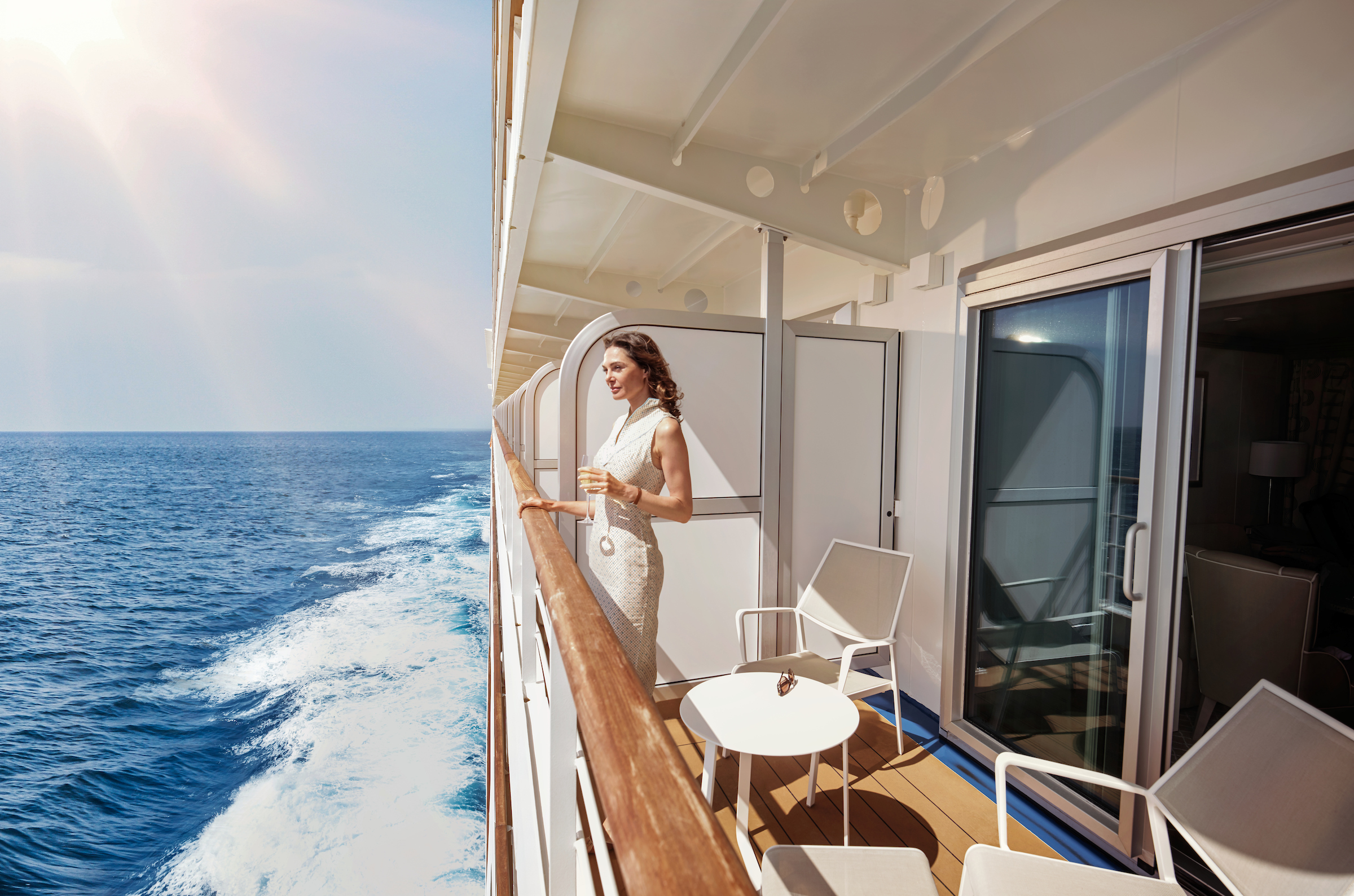
Located on the upper deck, and offering spectacular sunset views, the Superior Veranda Suite has all the comforts and luxury that you can expect aboard. A comfortable living space, attention to detail and a generous expanse of amenities, this stunning suite makes for a cosy home while on the seas. But perhaps this suite’s finest asset lies just outside, as floor-to-ceiling glass doors open onto a private veranda, making every sunset feel as if it is yours alone.
One bedroom: 32 sq m including veranda (6 sq m)
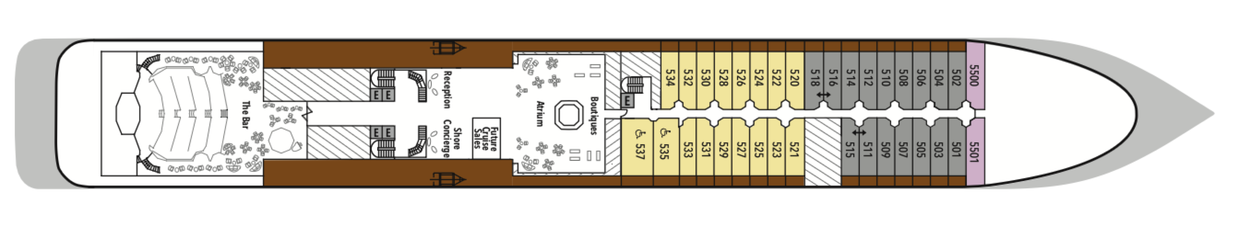
Wheelchair accessible suites: 535 and 537
Please note that the 3rd guest will sleep on a comfortable sofa bed in the reception area of the suite.Essentials
- Deck(s): 5, 6, 7, 8
- Section: Forward, Mid-Ship
Characteristics
- Veranda
- Sitting area
- Double vanity
- Separate shower
- Full-size bath
- Walk-in wardrobe with personal safe
Furniture
- Queen size bed
- Writing desk
- Vanity table
- Luxury bed mattresses
Media & Communication
- Unlimited Standard Wi-Fi
- 1 large flat screen TV with Interactive Media Library
- Direct dial telephone
- Wall mounted USB-C mobile device chargers
- Dual voltage 110/220 outlets
Onboard Services
- Butler service
- Champagne on arrival
Amenities
- Pillow menu
- Espresso Machine
- Tea Kettle
- Refrigerator and bar setup stocked with your preferences
- Plush bathrobe
- Luxury bath amenities
- Umbrella
- Hair Dryer
- Slippers
The Classic Veranda Suite provides a generous living space for voyagers. Located on the lower decks in the bow, the Classic Veranda Suite offers all the comfort and attention to detail that you can expect aboard—both inside and out. A generous expanse of interior comforts—elegant decor, a stunning marble bathroom, and an ample seating area make this a cozy home away from home. But perhaps this suite’s finest asset lies just outside, as floor-to-ceiling glass doors open onto a private veranda, making every sunset feel as if it is yours alone.
One bedroom: 32 sq m including veranda (6 sq m)
Please note that the 3rd guest will sleep on a comfortable sofa bed in the reception area of the suite.
Essentials
- Deck(s): 5, 6
- Section: Forward, Mid-Ship
Characteristics
- Veranda
- Sitting area
- Double vanity
- Separate shower
- Full-size bath
- Walk-in wardrobe with personal safe
Furniture
- Queen size bed
- Writing desk
- Vanity table
- Luxury bed mattresses
Media & Communication
- Unlimited Standard Wi-Fi
- 1 large flat screen TV with Interactive Media Library
- Direct dial telephone
- Wall mounted USB-C mobile device chargers
- Dual voltage 110/220 outlets
Onboard Services
- Butler service
- Champagne on arrival
Amenities
- Pillow menu
- Espresso Machine
- Tea Kettles
- Refrigerator and bar setup stocked with your preferences
- Plush bathrobe
- Luxury bath amenities
- Umbrella
- Hair Dryer
- Slippers
A quiet sanctuary. The seating area of the Vista Suite has plenty of room to relax. Large picture windows frame panoramic ocean views. The perfect backdrop for breakfast in bed.
One bedroom: 27 sq m
Essentials
- Deck(s): 4, 5, 7
- Section: Forward
Characteristics
- Large Balcony Window
- Sitting area
- Double vanity
- Separate shower
- Full-size bath
- Walk-in wardrobe with personal safe
Furniture
- Queen size bed
- Writing desk
- Vanity table
- Luxury bed mattresses
Media & Communication
- Unlimited Standard Wi-Fi
- 1 large flat screen TV with Interactive Media Library
- Direct dial telephone
- Wall mounted USB-C mobile device chargers
- Dual voltage 110/220 outlets
Onboard Services
- Butler service
- Champagne on arrival
Amenities
- Pillow menu
- Espresso Machine
- Tea Kettles
- Refrigerator and bar setup stocked with your preferences
- Plush bathrobe
- Luxury bath amenities
- Umbrella
- Hair Dryer
- Slippers
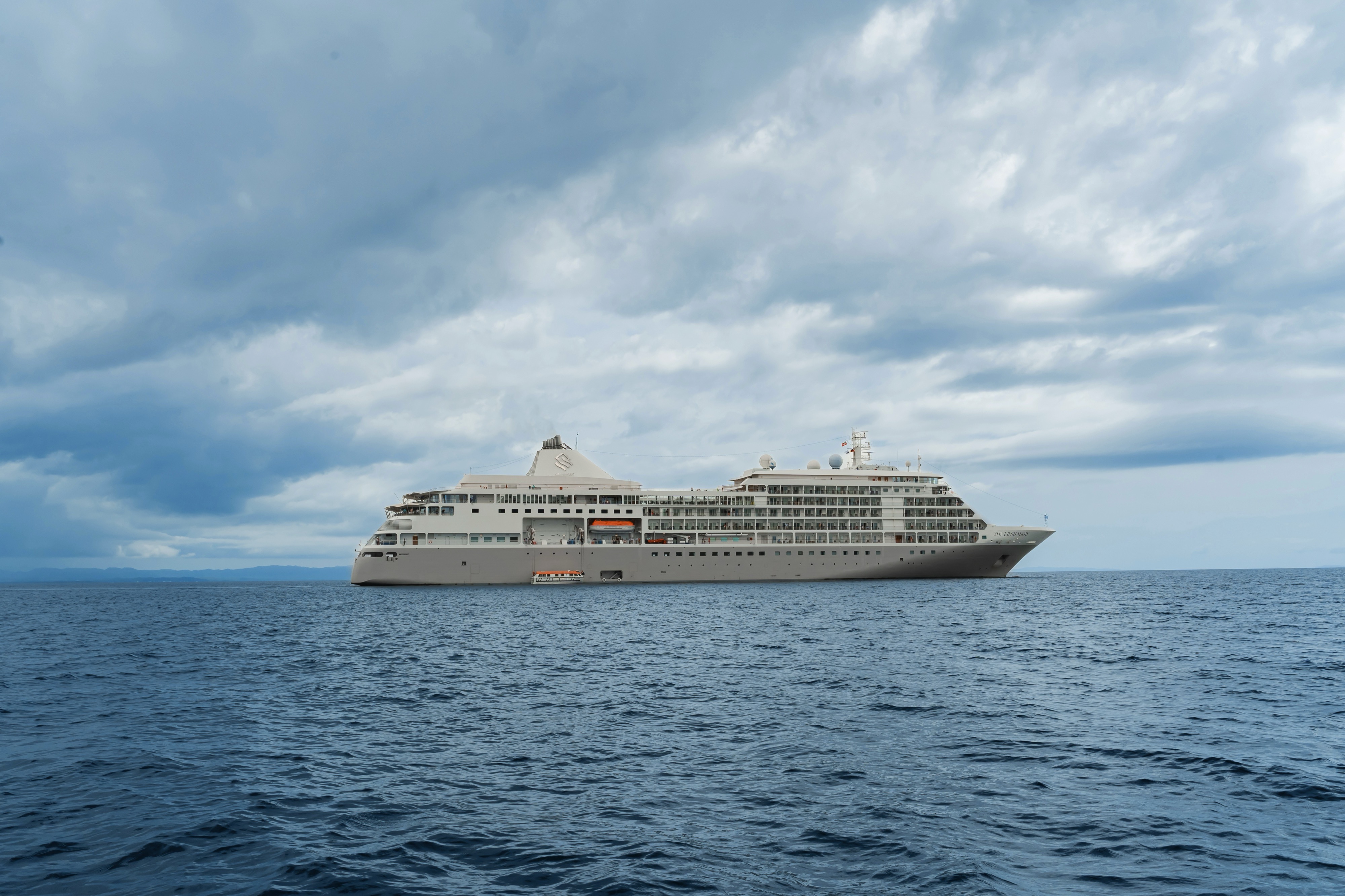
Silver Shadow
Award-winning Silver Shadow is a firm favorite in the Silversea fleet. With one of the highest space-to-guest ratios at sea, she offers authentic experiences, simple pleasures, and shared moments.
Silversea’s Shadow Class luxury cruise ships Silver Shadow and Silver Whisper offer you freedom and space to design your day. Silver Shadow retains Silversea’s essence—spacious suites and superior service—paired with a lively cosmopolitan atmosphere and enhanced amenities. Energise body and mind in the upgraded spa and fitness centre. Savour fine wines and French gastronomy in La Dame and enjoy authentic Italian cuisine in La Terrazza, endless ocean views from The Grill, and internationally inspired dishes in The Restaurant. From delectable dining to relaxation in ultra luxury, cruising has never felt so good.
Ship Facts
| Launch Year | 2000 | ||||||||||
| Refit Year | 2019 | ||||||||||
| Language | en | ||||||||||
| Gross Tonnage | 28258 | ||||||||||
| Length | 186 | ||||||||||
| Width | 24 | ||||||||||
| Currency | USD | ||||||||||
| Speed | 21 | ||||||||||
| Capacity | 392 | ||||||||||
| Crew Count | 302 | ||||||||||
| Deck Count | 7 | ||||||||||
| Cabin Count | 194 | ||||||||||
| Large Cabin Count | 39 | ||||||||||
| Wheelchair Cabin Count | 2 | ||||||||||
| Electrical Plugs |
|
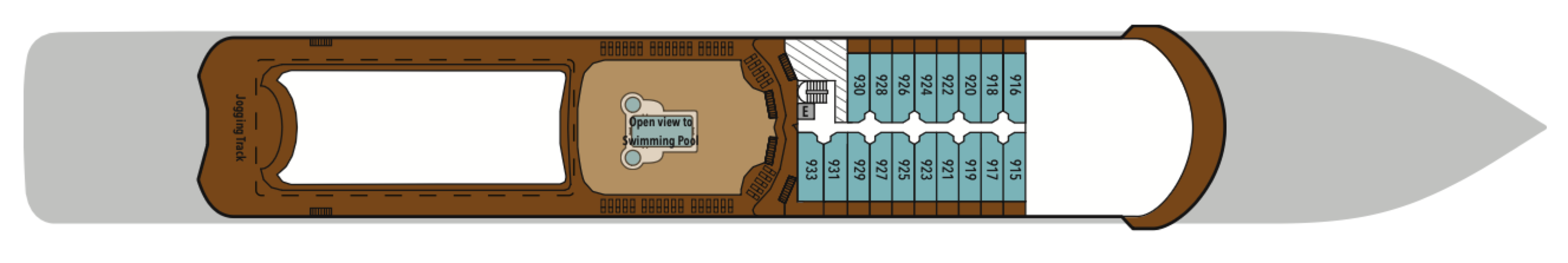
Deck 10
- Fitness Centre
- Zagara Beauty Spa
- Beauty Salon
- Observation Library

Deck 9
- Jogging Track
- Deluxe Veranda Suites
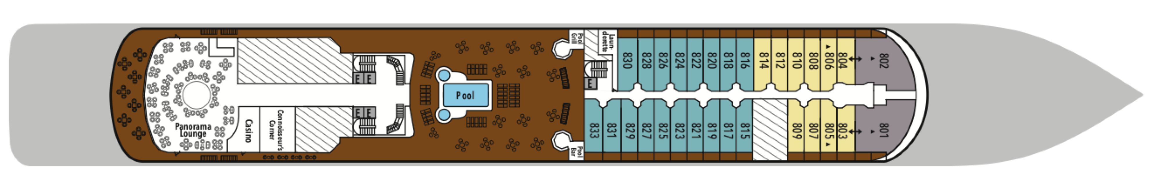
Deck 8
- Pool Deck
- Pool Bar
- The Grill
- Connoisseur's Corner
- Casino
- Panorama Lounge
- Launderette
- Grand Suites
- Superior Veranda Suites
- Deluxe Veranda Suites
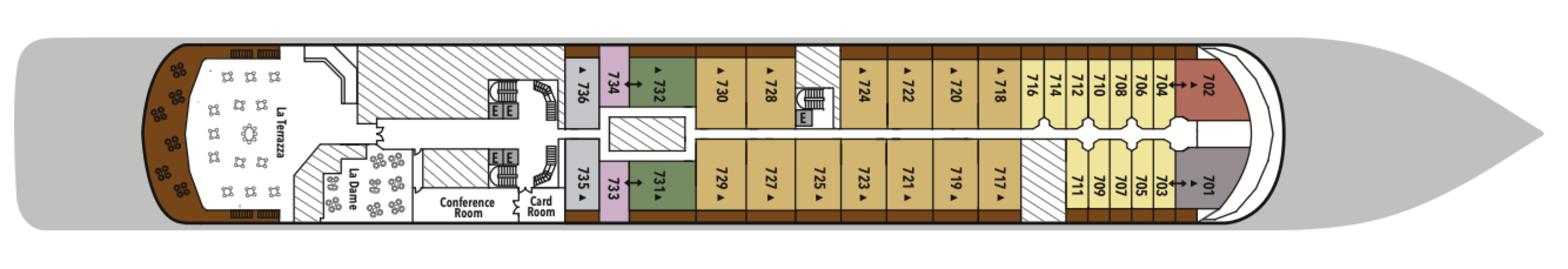
Deck 7
- La Terrazza
- La Dame
- Conference/Card Room
- Owner's Suite
- Grand Suites
- Royal Suites
- Silver Suites
- Medallion Suites
- Superior Veranda Suites
- Vista Suites
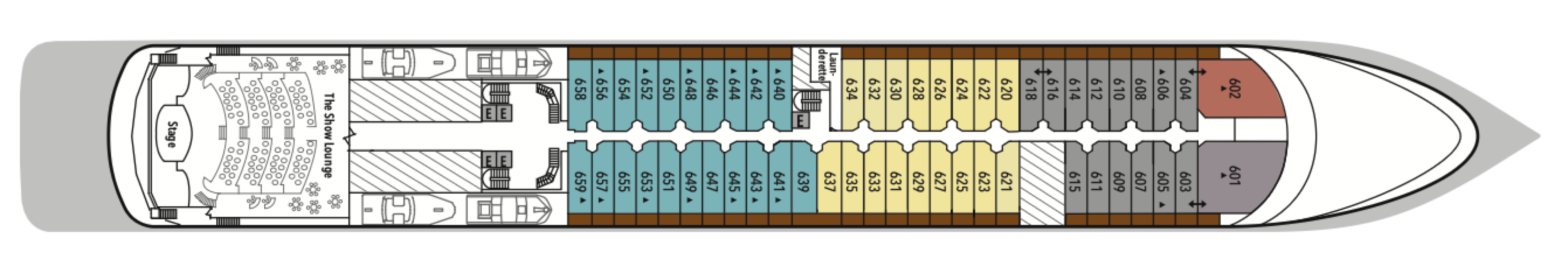
Deck 6
- The Show Lounge
- Launderette
- Grand Suites
- Royal Suites
- Superior Veranda Suites
- Deluxe Veranda Suites
- Classic Veranda Suites
Deck 5
- Boutiques
- Atrium
- Launderette
- Reception/Guest Relations
- Future Cruise Sales
- Shore Concierge
- The Bar
- The Show Lounge
- Superior Veranda Suites
- Vista Suites
- Classic Veranda Suites
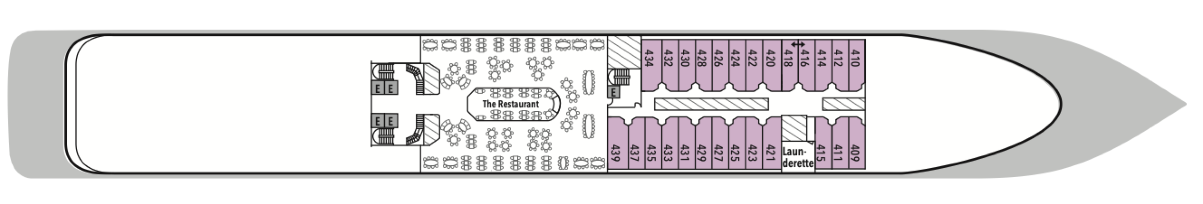
Deck 4
- The Restaurant
- Launderette
- Vista Suites
Our passion for excellent cuisine is at the heart of everything we do. We believe that meals are a celebration of life, a way to bring people together, and an expression of culture and tradition. Each dining venue aboard our ships offers a unique and memorable experience, with multiple dining options available and a variety of spaces and experiences on board; every mealtime is a joy.
From fine French cuisine and flavourful Asian options to relaxed Italian meals and international options to suit everyone, our chefs’ creativity knows no limits.
With the importance of food in our culture, it’s no wonder that dining is a high priority at Silversea. We believe gastronomic excellence is a given, thanks to recipes that reflect our heritage and revamp tradition. No matter where you dine, destination influence is readily apparent in the great diversity and freshness of your selections. And every luxury ship also features an array of dining venues. Per guest reservation fee for specialty restaurants. Please visit MySilversea to make your reservations.
The Restaurant
The Restaurant transforms dining into an extraordinary journey of taste. Indulge in international delicacies, refined classics, and destination-driven creations that reflect the flavours of the region you’re exploring. From breakfast favourites to imaginative evening courses, every meal draws inspiration from your voyage.
La Dame
Experience the pinnacle of French gastronomy at La Dame, where sophistication meets tradition. Here, an exclusive tasting menu unfolds course by course — each plate a study in masterful technique, seasonal ingredients, and modern refinement. From classic Kir Royales to exquisite signatures such as Dover sole à la Grenobloise, this is haute cuisine at its finest.
Per guest reservation fee of US$60. Please visit My Silversea to make your reservations.
La Terrazza
La Terrazza elevates casual dining by day and delivers an authentic Italian experience by night. During the breakfast and lunch buffets, our master chefs prepare global favorites at live stations. As evening falls, handmade pastas and classic seafood dishes are the centerpiece — every impeccable bite paired with fine wines from around the world.
Open seating for breakfast and lunch.
Reservations required for dinner.
The Grill
A poolside al fresco favorite, The Grill is casual by day and captivating by night. Dig in to crisp salads and grilled classics during lunch, then return after sunset for masterfully seasoned and seared cuts paired with balmy sea breezes.
Dress code: Casual
Casual wear consists of pants, blouses, or casual dresses for women; open-neck shirts and slacks for men are appropriate.
Images are intended as a general reference. Features, materials, finishes and layout may be different than shown.
In Suite Dining
You can order from our Room Service menu 24 hours a day.
Opening hours are for reference only. For precise opening hours, please refer to the Daily Chronicles provided on board.
Human connection and a sense of community is at the heart of every Silversea voyage, which is why we’ve created a variety of spaces on board to share the experience with your fellow adventurers. Relax in one of our many bars or restaurants with your favourite tipple and swap stories with other guests. Workout in our fully equipped gym or try our elite spa services. Sip a glass of bubbly by the pool by day, or a fine cognac in one of our elegant bars by night.
When you embark on an adventure with Silversea, we keep you thoroughly entertained while you’re sailing from one glorious port to another. Exploring the many different floors and strolling around the variety of areas on your ship is great fun as there’s always so much to see and do. Whether you want to recline on a lounger by the pool, try your luck in the casino, or indulge in our cutting-edge wellness and exercise programs, there’s something for everyone, including those who want to relax in their suite while their butler runs a bubble bath.
Atrium
The Atrium aboard provides a unique space at the heart of deck 5. Filled with natural light, a beautiful and spacious bar blurs the line between traditional bar and modern brasserie, and offers an all-day venue for drinks and snacks in a relaxed, welcoming atmosphere. The elegant café serves light bites, as well as smoothies, fresh juices, bespoke cocktails, and wine by the glass from our extensive drinks menu, and it is the ideal place to meet your friends, grab a coffee or aperitif, and plan your next adventures.
Observation Library
Wrapped in glass and bathed in light, the Observation Lounge offers a serene escape high above the sea. Borrow a book from the in-house library, pour yourself a coffee or tea from the self-service bar, and curl into an armchair to watch the world drift by. This is a sanctuary for reflection, relaxation, and stories — both written and still in the making.
Panorama Lounge
True to its name, Panorama Lounge surrounds you with sweeping views from every angle. Sunlight pours through wraparound windows by day, framing horizons that shift like watercolors. Evenings hum with piano chords and DJ beats that carry you late into the night. And all of it pairs wonderfully with cocktails handcrafted to match your mood.
Boutique
Exceptional shopping experiences do not end in the cosmopolitan cities we visit. Silversea’s striking new shipboard boutiques, reimagined and redesigned, are stunning modern design spaces befitting the finest creations from legendary designers. Carefully selected partners in Silversea’s onboard, duty-free boutiques offer our guests a carefully curated selection of cutting-edge fashions, jewelry, accessories, fine perfumes, cosmetics, and Silversea Logo collection, all at duty-free prices.
Connoisseur's Corner
As evening stretches into night, Connoisseur’s Corner offers a stylish refuge for those who appreciate the time-honored rituals of smoke and spirit. Sink into tufted leather chairs with a hand-rolled cigar and a glass of one of our finest cognacs or whiskeys. Indoors or under the stars, every moment is marked by pure indulgence.
The Show Lounge
At The Show Lounge, theatrical immersion takes centre stage. From captivating performances and screenings to cultural programs, this elegant venue was designed to dazzle. Tiered seating ensures impeccable views while attentive beverage service makes indulging effortless. Raise a glass as the curtain rises on an unforgettable night of entertainment.
Card Room/Conference Room
The Card Room on board this luxury cruise ship is where bridge games and tournaments take place most days. On days at sea, newcomers to the game can learn how to play. Should your group require a conference or meeting space, Silversea is pleased to provide a tailor-made experience. Audiovisual equipment is available and complimentary aboard all luxury cruise ships.
Casino
Roulette, blackjack, and slot machines are available in The Casino for guests 18 years old or older. If you are a novice, come to the champagne reception and learn all the games offered aboard this luxury cruise ship.
Reception
This central lobby area welcomes guests to speak with a Guest Relations specialist should they have a question or require any service. Assistance is available 24 hours a day. For guests wishing to make shoreside arrangements, the Silver Shore Concierge is available to assist with knowledgeable suggestions and personalised coordination of all private, independent touring, including sightseeing, water sports, golf, and more. The Cruise Consultant may prove indispensable when planning your next Silversea voyage, or if you wish to extend your current voyage for a day, a week, a month … Like having your own personal onboard Silversea professional, the Cruise Consultant will help you to select the perfect voyage, reserve your preferred suite, and provide immediate confirmation.