
North Pacific Crossing
North Pacific Crossing
Cruise overview
WHY BOOK WITH US?
- ✔ The Deluxe Cruises’ team has extensive experience in ultra-luxury cruising.
- ✔ Call now to speak to our helpful and experienced Cruise Concierge team.
- ✔ Enjoy our Unique Deluxe Cruises Bonus for substantial savings.
- ✔ Our team will tailor your holiday to your exacting requirements.
- ✔ As agents, we work under the protection of each cruise lines ABTA / ATOL licences
About Yokohama
In 1853, a fleet of four American warships under Commodore Matthew Perry sailed into the bay of Tokyo (then Edo) and presented the reluctant Japanese with the demands of the U.S. government for the opening of diplomatic and commercial relations. The following year Perry returned and first set foot on Japanese soil at Yokohama—then a small fishing village on the mudflats of Tokyo bay. Two years later New York businessman Townsend Harris became America's first diplomatic representative to Japan. In 1858 he was finally able to negotiate a commercial treaty between the two countries; part of the deal designated four locations—one of them Yokohama—as treaty ports. In 1859 the shogunate created a special settlement in Yokohama for the growing community of merchants, traders, missionaries, and other assorted adventurers drawn to this exotic new land of opportunity. The foreigners (predominantly Chinese and British, plus a few French, Americans, and Dutch) were confined here to a guarded compound about 5 square km (2 square miles)—placed, in effect, in isolation—but not for long. Within a few short years the shogunal government collapsed, and Japan began to modernize. Western ideas were welcomed, as were Western goods, and the little treaty port became Japan's principal gateway to the outside world. In 1872 Japan's first railway was built, linking Yokohama and Tokyo. In 1889 Yokohama became a city; by then the population had grown to some 120,000. As the city prospered, so did the international community and by the early 1900s Yokohama was the busiest and most modern center of international trade in all of East Asia. Then Yokohama came tumbling down. On September 1, 1923, the Great Kanto Earthquake devastated the city. The ensuing fires destroyed some 60,000 homes and took more than 40,000 lives. During the six years it took to rebuild the city, many foreign businesses took up quarters elsewhere, primarily in Kobe and Osaka, and did not return. Over the next 20 years Yokohama continued to grow as an industrial center—until May 29, 1945, when in a span of four hours, some 500 American B-29 bombers leveled nearly half the city and left more than half a million people homeless. When the war ended, what remained became—in effect—the center of the Allied occupation. General Douglas MacArthur set up headquarters here, briefly, before moving to Tokyo; the entire port facility and about a quarter of the city remained in the hands of the U.S. military throughout the 1950s. By the 1970s Yokohama was once more rising from the debris; in 1978 it surpassed Osaka as the nation's second-largest city, and the population is now inching up to the 3.5 million mark. Boosted by Japan's postwar economic miracle, Yokohama has extended its urban sprawl north to Tokyo and south to Kamakura—in the process creating a whole new subcenter around the Shinkansen Station at Shin-Yokohama. The development of air travel and the competition from other ports have changed the city's role in Japan's economy. The great liners that once docked at Yokohama's piers are now but a memory, kept alive by a museum ship and the occasional visit of a luxury vessel on a Pacific cruise. Modern Large as Yokohama is, the central area is very negotiable. As with any other port city, much of what it has to offer centers on the waterfront—in this case, on the west side of Tokyo Bay. The downtown area is called Kannai (literally, "within the checkpoint"); this is where the international community was originally confined by the shogunate. Though the center of interest has expanded to include the waterfront and Ishikawa-cho, to the south, Kannai remains the heart of town. Think of that heart as two adjacent areas. One is the old district of Kannai, bounded by Basha-michi on the northwest and Nippon-odori on the southeast, the Keihin Tohoku Line tracks on the southwest, and the waterfront on the northeast. This area contains the business offices of modern Yokohama. The other area extends southeast from Nippon-odori to the Moto-machi shopping street and the International Cemetery, bordered by Yamashita Koen and the waterfront to the northeast; in the center is Chinatown, with Ishikawa-cho Station to the southwest. This is the most interesting part of town for tourists. Whether you're coming from Tokyo, Nagoya, or Kamakura, make Ishikawa-cho Station your starting point. Take the South Exit from the station and head in the direction of the waterfront.
About Sapporo

About Sapporo
About Kodiak, Alaska
Today, commercial fishing is king in Kodiak. Despite its small population—about 6,475 people scattered among the several islands in the Kodiak group—the city is among the busiest fishing ports in the United States. The harbor is also an important supply point for small communities on the Aleutian Islands and the Alaska Peninsula.Visitors to the island tend to follow one of two agendas: either immediately fly out to a remote lodge for fishing, kayaking, or bear viewing; or stay in town and access whatever pursuits they can reach from the limited road system. If the former is too pricey an option, consider combining the two: drive the road system to see what can be seen inexpensively, then add a fly-out or charter-boat excursion to a remote lodge or wilderness access point.Floatplane and boat charters are available from Kodiak to many remote attractions, chief among them the Kodiak National Wildlife Refuge , which covers four islands in the Gulf of Alaska: Kodiak, Afognak, Ban, and Uganik.

About Homer, Alaska
At the southern end of the Sterling Highway lies the city of Homer, at the base of a narrow spit that juts 4 miles into beautiful Kachemak Bay. Glaciers and snowcapped mountains form a dramatic backdrop across the water. Founded in the late 1800s as a gold-prospecting camp, this community was later used as coal-mining headquarters. Chunks of coal are still common along local beaches; they wash into the bay from nearby slopes where the coal seams are exposed. Today the town of Homer is an eclectic community with most of the tacky tourist paraphernalia relegated to the Spit (though do note the Spit has plenty else to recommend it, not the least of which is the 360-degree view of the surrounding mountains); the rest of the town is full of local merchants and artisans. The community is an interesting mix of fishermen, actors, artists, and writers. Much of the commercial fishing centers on halibut, and the popular Homer Jackpot Halibut Derby is often won by enormous fish weighing more than 300 pounds. The local architecture includes everything from dwellings that are little more than assemblages of driftwood to steel commercial buildings and magnificent homes on the hillside overlooking the surrounding bay, mountains, forests, and glaciers.
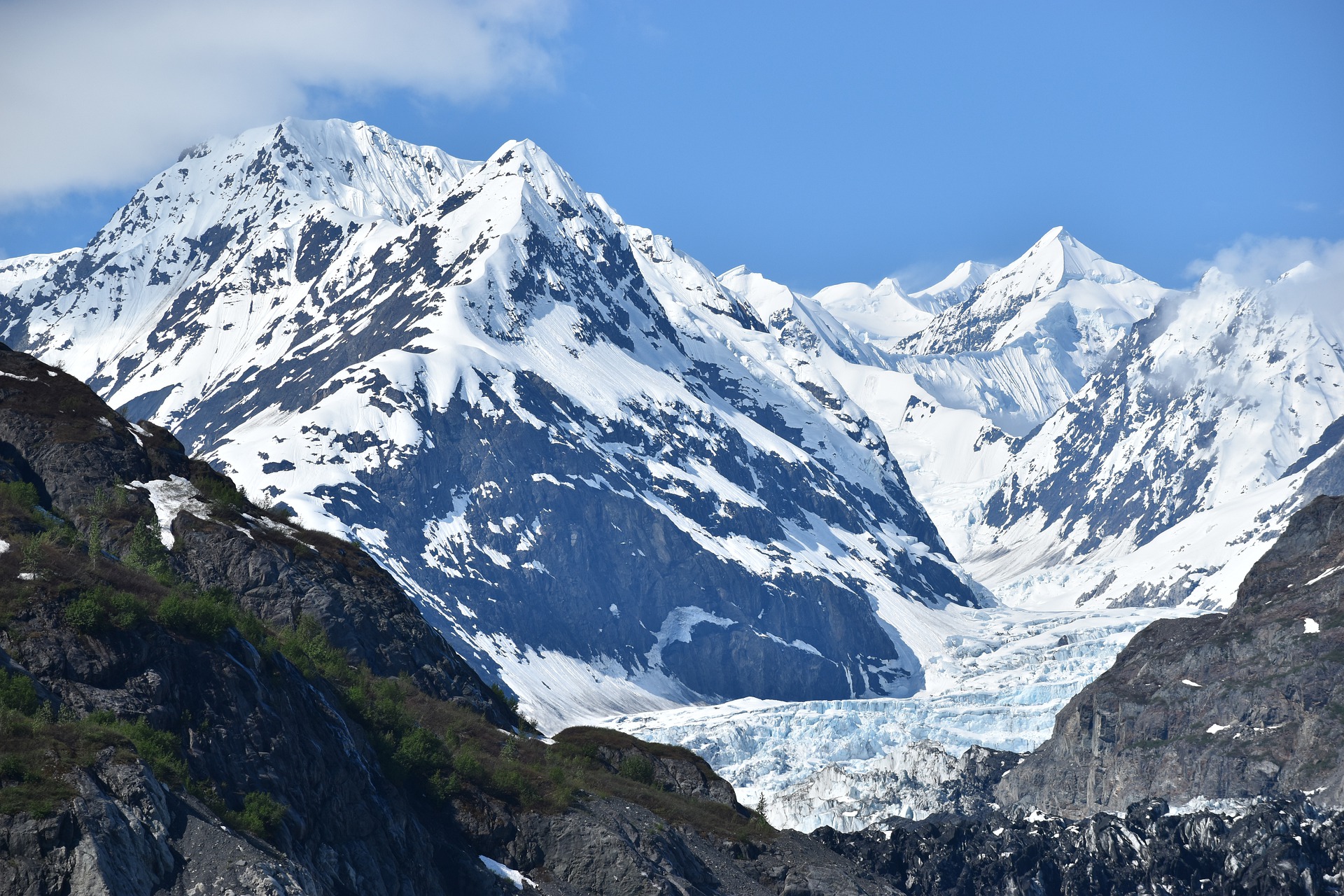
About Seward, Alaska
It is hard to believe that a place as beautiful as Seward exists. Surrounded on all sides by Kenai Fjords National Park, Chugach National Forest, and Resurrection Bay, Seward offers all the quaint realities of a small railroad town with the bonus of jaw-dropping scenery. This little town of about 2,750 citizens was founded in 1903, when survey crews arrived at the ice-free port and began planning a railroad to the Interior. Since its inception, Seward has relied heavily on tourism and commercial fishing. It is also the launching point for excursions into Kenai Fjords National Park, where it is quite common to see marine life and calving glaciers.


About Valdez, Alaska
About Sitka, Alaska
It's hard not to like Sitka, with its eclectic blend of Alaska Native, Russian, and American history and its dramatic and beautiful open-ocean setting. This is one of the best Inside Passage towns to explore on foot, with St. Michael's Cathedral, Sheldon Jackson Museum, Castle Hill, Sitka National Historical Park, and the Alaska Raptor Center topping the must-see list.Sitka was home to the Kiksádi clan of the Tlingit people for centuries prior to the 18th-century arrival of the Russians under the direction of territorial governor Alexander Baranof, who believed the region was ideal for the fur trade. The governor also coveted the Sitka site for its beauty, mild climate, and economic potential; in the island's massive timber forests he saw raw materials for shipbuilding. Its location offered trading routes as far west as Asia and as far south as California and Hawaii. In 1799 Baranof built St. Michael Archangel—a wooden fort and trading post 6 miles north of the present town.Strong disagreements arose shortly after the settlement. The Tlingits attacked the settlers and burned their buildings in 1802. Baranof, however, was away in Kodiak at the time. He returned in 1804 with a formidable force—including shipboard cannons—and attacked the Tlingits at their fort near Indian River, site of the present-day 105-acre Sitka National Historical Park, forcing many of them north to Chichagof Island.By 1821 the Tlingits had reached an accord with the Russians, who were happy to benefit from the tribe's hunting skills. Under Baranof and succeeding managers, the Russian-American Company and the town prospered, becoming known as the Paris of the Pacific. The community built a major shipbuilding and repair facility, sawmills, and forges, and even initiated an ice industry, shipping blocks of ice from nearby Swan Lake to the booming San Francisco market. The settlement that was the site of the 1802 conflict is now called Old Sitka. It is a state park and listed as a National Historic Landmark.The town declined after its 1867 transfer from Russia to the United States, but it became prosperous again during World War II, when it served as a base for the U.S. effort to drive the Japanese from the Aleutian Islands. Today its most important industries are fishing, government, and tourism.

About Icy Strait Point
Since Icy Strait Point opened in 2004, Hoonah has attracted more visitors, particularly those who arrive by cruise ship. The port is centered around the restored salmon cannery, which now houses a museum, local arts and crafts shops, restaurants, and a mid-1930s cannery line display. Outside is the world’s largest and highest zip line at 5,330 feet long, featuring a 1,300-foot vertical drop—a thrilling ride with fantastic views of the surrounding mountains and ocean. If you're looking for more relaxing mountaintop views, book a gondola ride that will whisk you up into the mountains for some leisurely hiking and stellar sightseeing. Icy Strait Point houses several restaurants where visitors can dine on freshly caught seafood while taking in the waterfront views. A range of excursions are available at Icy Strait Point catering primarily to cruise ship passengers, from Alaska Native dance performances to bear viewing and whale watching.

About Skagway, Alaska
Located at the northern terminus of the Inside Passage, Skagway is a one-hour ferry ride from Haines. By road, however, the distance is 359 miles, as you have to take the Haines Highway up to Haines Junction, Yukon, then take the Alaska Highway 100 miles south to Whitehorse, and then drive a final 100 miles south on the Klondike Highway to Skagway. North-country folk call this sightseeing route the Golden Horseshoe or Golden Circle tour, because it passes a lot of gold-rush country in addition to spectacular lake, forest, and mountain scenery.The town is an amazingly preserved artifact from North America's biggest, most-storied gold rush. Most of the downtown district forms part of the Klondike Gold Rush National Historical Park, a unit of the National Park System dedicated to commemorating and interpreting the frenzied stampede of 1897 that extended to Dawson City in Canada's Yukon.Nearly all the historic sights are within a few blocks of the cruise-ship and ferry dock, allowing visitors to meander through the town's attractions at whatever pace they choose. Whether you're disembarking from a cruise ship, a ferry, or a dusty automobile fresh from the Golden Circle, you'll quickly discover that tourism is the lifeblood of this town. Unless you're visiting in winter or hiking into the backcountry on the Chilkoot Trail, you aren't likely to find a quiet Alaska experience around Skagway.

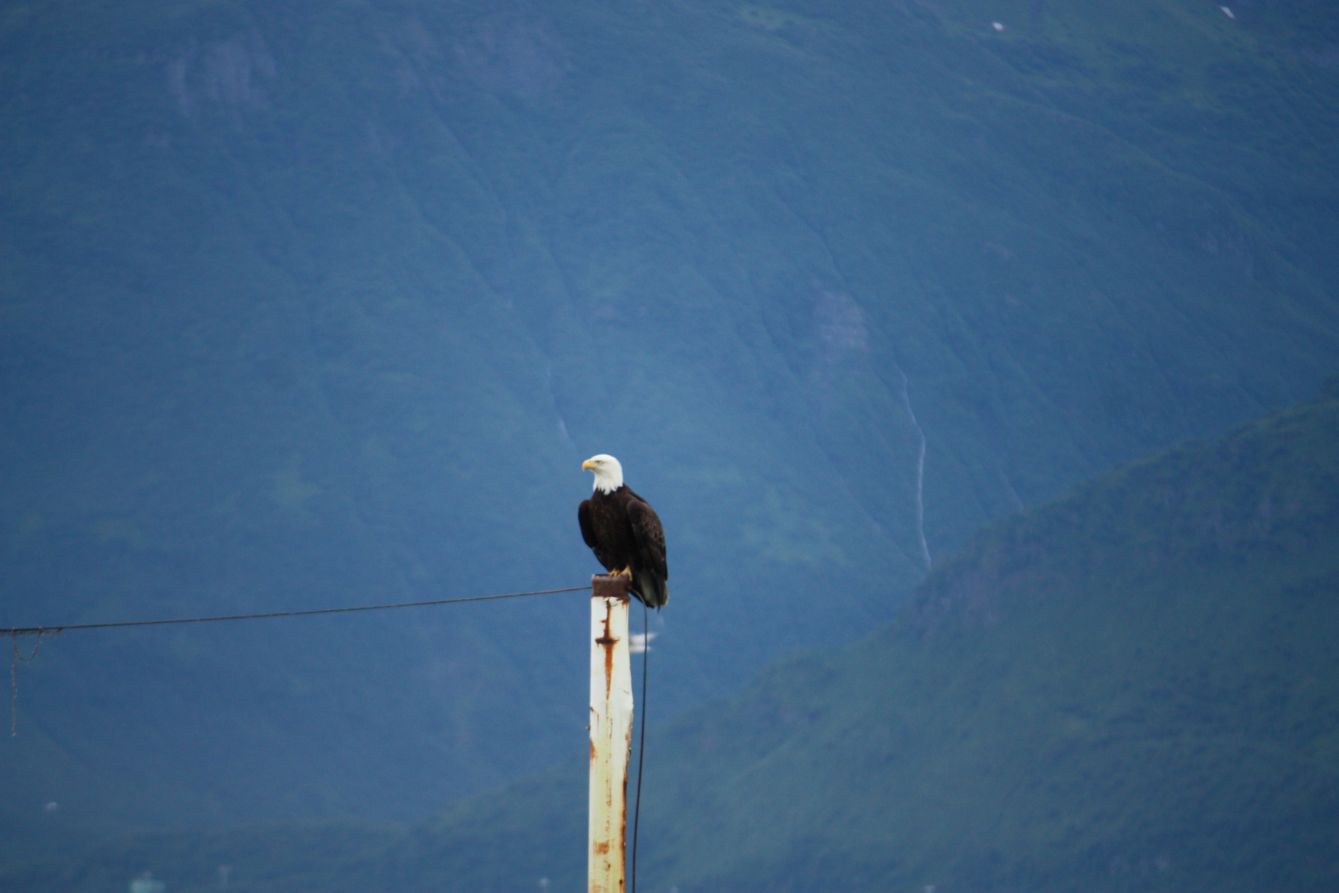
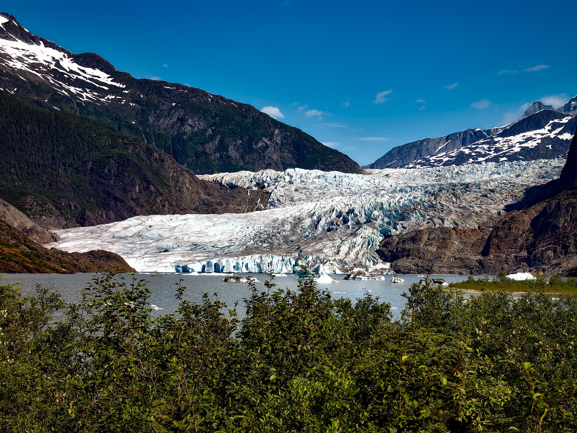
About Juneau, Alaska
Juneau, Alaska's capital and third-largest city, is on the North American mainland but can't be reached by road. Bounded by steep mountains and water, the city’s geographic isolation and compact size make it much more akin to an island community such as Sitka than to other Alaskan urban centers, such as Fairbanks or Anchorage. Juneau is full of contrasts. Its dramatic hillside location and historic downtown buildings provide a frontier feeling, but the city's cosmopolitan nature comes through in fine museums, noteworthy restaurants, and a literate and outdoorsy populace. The finest of the museums, the Alaska State Museum, is scheduled to reopen in May 2016 on its old site as the expanded Alaska State Library, Archives, and Museum (SLAM) following several years of planning and exhibit research. Another new facility, the Walter Soboleff Center, offers visitors a chance to learn about the indigenous cultures of Southeast Alaska–-Tlingit, Haida, and Tsimshian. Other highlights include the Mt. Roberts Tramway, plenty of densely forested wilderness areas, quiet bays for sea kayaking, and even a famous drive-up glacier, Mendenhall Glacier. For goings-on, pick up the Juneau Empire (www.juneauempire.com), which keeps tabs on state politics, business, sports, and local news.


About Ketchikan, Alaska
Ketchikan is famous for its colorful totem poles, rainy skies, steep–as–San Francisco streets, and lush island setting. Some 13,500 people call the town home, and, in the summer, cruise ships crowd the shoreline, floatplanes depart noisily for Misty Fiords National Monument, and salmon-laden commercial fishing boats motor through Tongass Narrows. In the last decade Ketchikan's rowdy, blue-collar heritage of logging and fishing has been softened by the loss of many timber-industry jobs and the dramatic rise of cruise-ship tourism. With some effort, though, visitors can still glimpse the rugged frontier spirit that once permeated this hardscrabble cannery town. Art lovers should make a beeline for Ketchikan: the arts community here is very active. Travelers in search of the perfect piece of Alaska art will find an incredible range of pieces to choose from.The town is at the foot of 3,000-foot Deer Mountain, near the southeastern corner of Revillagigedo (locals shorten it to Revilla) Island. Prior to the arrival of white miners and fishermen in 1885, the Tlingit used the site at the mouth of Ketchikan Creek as a summer fish camp. Gold discoveries just before the turn of the 20th century brought more immigrants, and valuable timber and commercial fishing resources spurred new industries. By the 1930s the town bragged that it was the "salmon-canning capital of the world." You will still find some of Southeast's best salmon fishing around here. Ketchikan is the first bite of Alaska that many travelers taste. Despite its imposing backdrop, hillside homes, and many staircases, the town is relatively easy to walk through. Favorite downtown stops include the Spruce Mill Development shops and Creek Street. A bit farther away you'll find the Totem Heritage Center. Out of town (but included on most bus tours) are two longtime favorites: Totem Bight State Historical Park to the north and Saxman Totem Park to the south.


About Vancouver, British Columbia
Vancouver is a delicious juxtaposition of urban sophistication and on-your-doorstep wilderness adventure. The mountains and seascape make the city an outdoor playground for hiking, skiing, kayaking, cycling, and sailing—and so much more—while the cuisine and arts scenes are equally diverse, reflecting the makeup of Vancouver's ethnic (predominantly Asian) mosaic. Vancouver is consistently ranked as one of the world's most livable cities, and it's easy for visitors to see why. It's beautiful, it's outdoorsy, and there's a laidback West Coast vibe. On the one hand, there's easy access to a variety of outdoor activities, a fabulous variety of beaches, and amazing parks. At the same time, the city has a multicultural vitality and cosmopolitan flair. The attraction is as much in the range of food choices—the fresh seafood and local produce are some of North America's best—as it is in the museums, shopping, and nightlife.Vancouver's landscaping also adds to the city's walking appeal. In spring, flowerbeds spill over with tulips and daffodils while sea breezes scatter scented cherry blossoms throughout Downtown; in summer office workers take to the beaches, parks, and urban courtyards for picnic lunches and laptop meetings. More than 8 million visitors each year come to Vancouver, Canada's third-largest metropolitan area. Because of its peninsula location, traffic flow is a contentious issue. Thankfully, Vancouver is wonderfully walkable, especially in the downtown core. The North Shore is a scoot across the harbor, and the rapid-transit system to Richmond and the airport means that staying in the more affordable ’burbs doesn't have to be synonymous with sacrificing convenience. The mild climate, exquisite natural scenery, and relaxed outdoor lifestyle keep attracting residents, and the number of visitors is increasing for the same reasons. People often get their first glimpse of Vancouver when catching an Alaskan cruise, and many return at some point to spend more time here.


Where You'll Go


