37-Day Northwest Passage & Wild Labrador Coast
37-Day Northwest Passage & Wild Labrador Coast
Cruise overview
WHY BOOK WITH US?
- ✔ The Deluxe Cruises’ team has extensive experience in ultra-luxury cruising.
- ✔ Call now to speak to our helpful and experienced Cruise Concierge team.
- ✔ Enjoy our Unique Deluxe Cruises Bonus for substantial savings.
- ✔ Our team will tailor your holiday to your exacting requirements.
- ✔ As agents, we work under the protection of each cruise lines ABTA / ATOL licences
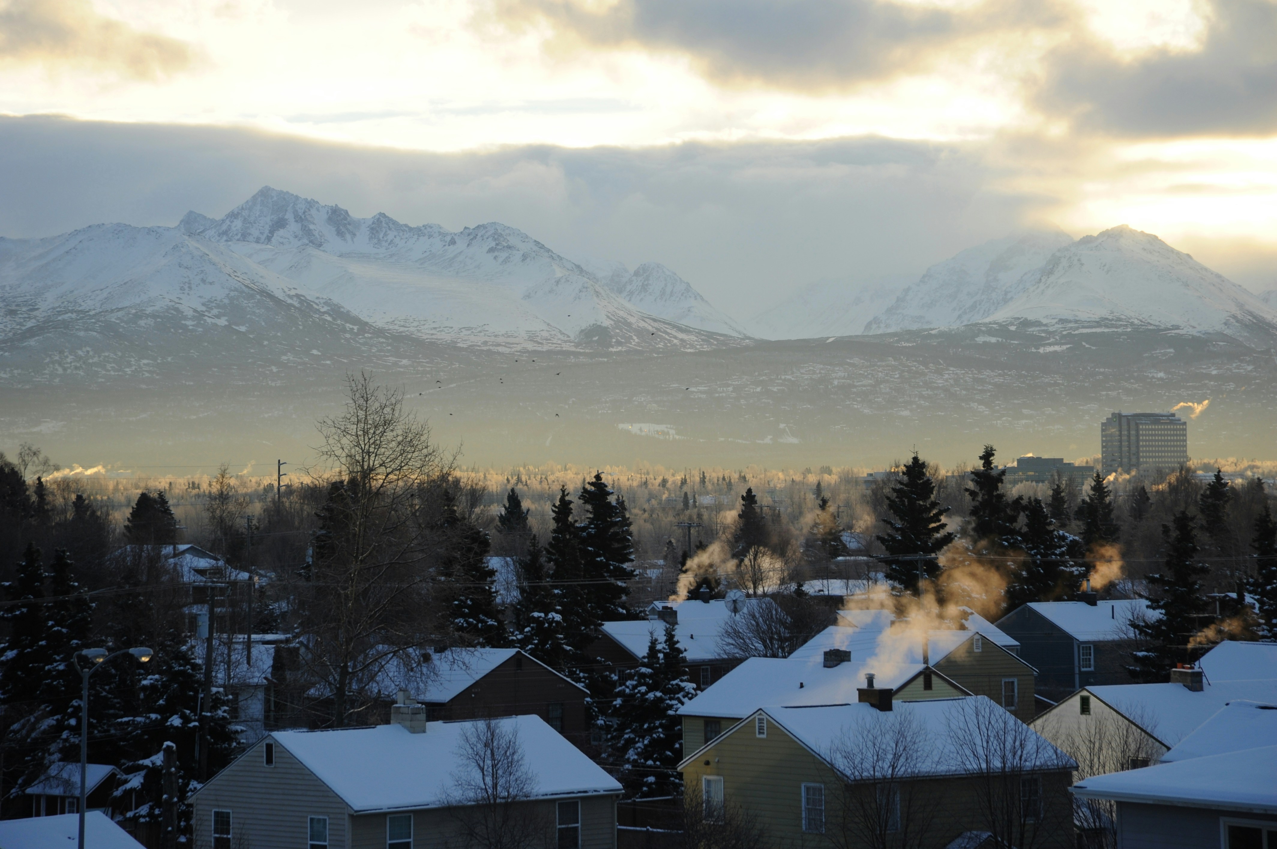
About Anchorage, Alaska
Anchorage is the largest city in Alaska. Located between mountains, it is a beautiful mixture of urban and wilderness. Thanks to its proximity to the Chugach State Park with its 45 species of mammals and the city's rich history, there is so much to be seen in this unique destination.


About Nome, Alaska
Nome is located on the edge of the Bering Sea, on the southwest side of the Seward Peninsula. Unlike other towns which are named for explorers, heroes or politicians, Nome was named as a result of a 50 year-old spelling error. In the 1850's an officer on a British ship off the coast of Alaska noted on a manuscript map that a nearby prominent point was not identified. He wrote "? Name" next to the point. When the map was recopied, another draftsman thought that the “?” was a C and that the “a” in "Name" was an o, and thus a map-maker in the British Admiralty christened "Cape Nome." The area has an amazing history dating back 10,000 years of Inupiaq Eskimo use for subsistence living. Modern history started in 1898 when "Three Lucky Swedes”, Jafet Lindberg, Erik Lindblom and John Brynteson, discovered gold in Anvil Creek…the rush was on! In 1899 the population of Nome swelled from a handful to 28,000. Today the population is just over 3,500. Much of Nome's gold rush architecture remains.

About Sachs Harbour, Northwest Territories
About Cambridge Bay, Nunavut
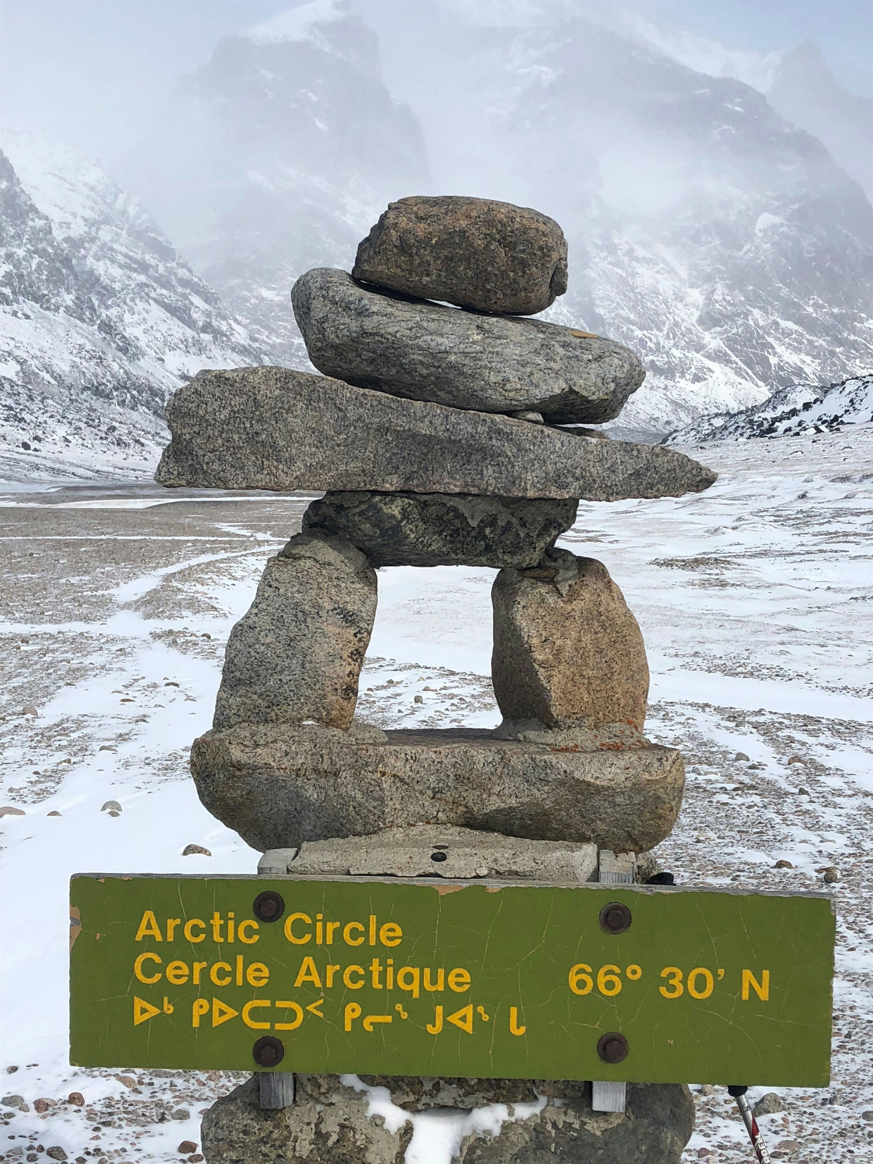
About Dundas Harbour, Devon Island, Nunavut
Dundas Harbour is located in the southeast of Devon Island, Canada’s 6th largest island. It is a forlorn but starkly beautiful spot. The island was first sighted by Europeans in 1616 by the English explorers Robert Bylot and William Baffin. But it did not appear on maps until after explorer William Edward Parry’s exploration in the 1820’s. Parry named it after Devon, England. In the local Inuktitut language, the place is called Talluruti, which translates as “a woman’s chin with tattoos on it.” This refers to the deep crevasses and streaks on Devon Island, which from a distance resemble traditional facial tattoos. On land there are remains of a Thule settlement dating back to 1000 A.D., including tent rings, middens and a gravesite. There are also much more recent remains a Royal Canadian Mounted Police outpost. The first post was established in 1924 to monitor and control illegal activities, such as foreign whaling, in the eastern entrance to the Northwest Passage. But conditions were so isolated and severe that the post was abandoned in 1933. It was reopened in 1945, but again closed, this time permanently, in 1951. Today, Devon Island is the largest uninhabited island in the world.

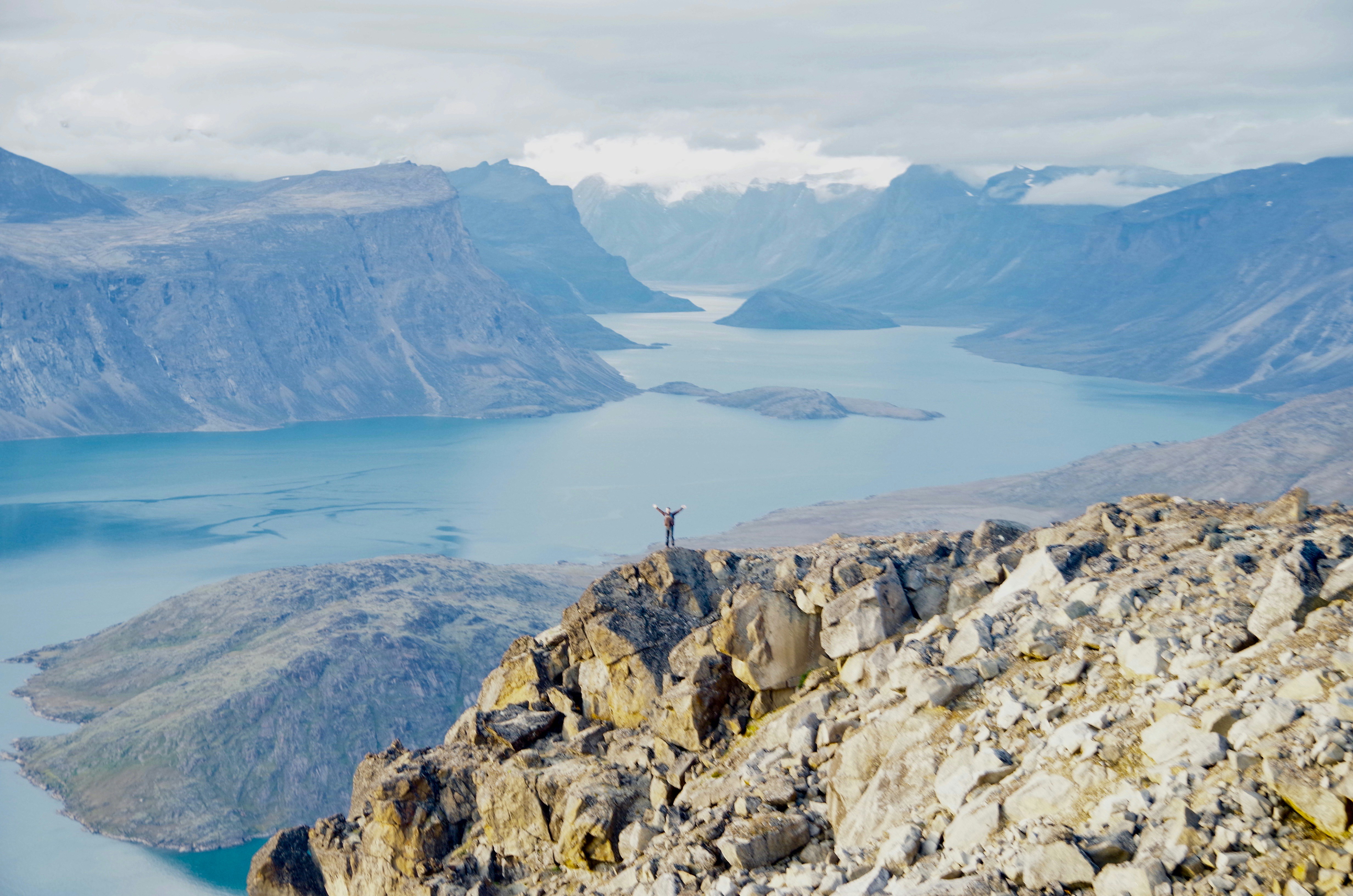
About Pond Inlet, Nunavut
Located in northern Baffin Island, Pond Inlet is a small, predo¬minantly Inuit community, with a population of roughly 1,500 inhabitants. In 1818, the British explorer John Ross named a bay in the vicinity after the English astronomer John Pond. Today Pond Inlet is considered one of Canada's "jewels of the North" thanks to several picturesque glaciers and mountain ranges nearby. Many archaeological sites of ancient Dorset and Thule peoples can be found near Pond Inlet. The Inuit hunted caribou, ringed and harp seals, fish, polar bears, walrus, narwhals, geese, ptarmigans and Arctic hares, long before European and American whalers came here to harvest bowhead whales. Pond Inlet is also known as a major center of Inuit art, especially the printmaking and stone carving that are featured in the town’s art galleries.

About Ilulissat (Jakobshavn)
Known as the birthplace of icebergs, the Ilulissat Icefjord produces nearly 20 million tons of ice each day. In fact, the word Ilulissat means “icebergs” in the Kalaallisut language. The town of Ilulissat is known for its long periods of calm and settled weather, but the climate tends to be cold due to its proximity to the fjord. Approximately 4,500 people live in Ilulissat, the third-largest town in Greenland after Nuuk and Sisimiut. Some people here estimate that there are nearly as many sled dogs as human beings living in the town that also boasts a local history museum located in the former home of Greenlandic folk hero and famed polar explorer Knud Rasmussen.
About Sisimiut (Holsteinsborg)
Located just north of the Arctic Circle, Sisimiut is the northernmost town in Greenland where the port remains free of ice in the winter. Yet it is also the southernmost town where there is enough snow and ice to drive a dogsled in winter and spring. In Sisimiut, travelling by sled has been the primary means of winter transportation for centuries. In fact, the area has been inhabited for approximately 4,500 years. Modern Sisimiut is the largest business center in the north of Greenland, and is one of the fastest growing Greenlandic cities. Commercial fishing is the lead economy in the town‘s thriving industrial base.
About Nuuk (Godthaab)
Nuuk, meaning “the cape”, was Greenland’s first town (1728). Started as a fort and later mission and trading post some 240 kilometers south of the Arctic Circle, it is the current capital. Almost 30% of Greenland’s population lives in the town. Not only does Nuuk have great natural beauty in its vicinity, but there are Inuit ruins, Hans Egede’s home, the parliament, and the Church of our Saviour as well. The Greenlandic National Museum has an outstanding collection of Greenlandic traditional dresses, as well as the famous Qilakitsoq mummies. The Katuaq Cultural Center’s building was inspired by the undulating Northern Lights and can house 10% of Nuuk’s inhabitants.
About Kangerlussuaq Havn
The name Kangerlussuaq means "Big Fjord" in the local Kalaallisut language. The settlement of about 500 people is located in western Greenland on flat land at the head of a fjord with the same name. Kangerlussuaq is the site of Greenland's largest commercial airport and most of the economy here is dependent on the air transportation hub and tourism. The rugged lands around the settlement support terrestrial Arctic fauna including muskoxen, caribou, and Gyrfalcons.
About Pangnirtung, Nunavut
About Lady Franklin Island, Nunavut
Named in honour of Sir John Franklin’s widow, the lonely and uninhabited Lady Franklin Island lies off of Baffin Island’s Hall Peninsula at the entrance to Cumberland Sound. The island is named for the wife of Sir John Franklin, the Arctic explorer who died trying to discover the Northwest Passage. The geology of the island is striking with vertical cliffs of Archean rocks, likely to be some of the oldest stone in Canada. The waters around Lady Franklin Island offer an abundance seabirds, ducks, seals, and walrus. With a bit of luck it is possible to see Atlantic Puffins here and perhaps even a rare Sabine’s Gull.
About Monument Island, Nunavut
About Lower Savage Islands, Nunavut
About Resolution Island, Qikiqtaaluk
About Nachvak Fiord, Newfoundland and Labrador
About Saglek Fjord, Newfoundland and Labrador
About Hebron, Newfoundland and Labrador
About Nain, Newfoundland and Labrador
About Indian Harbour, Newfoundland and Labrador
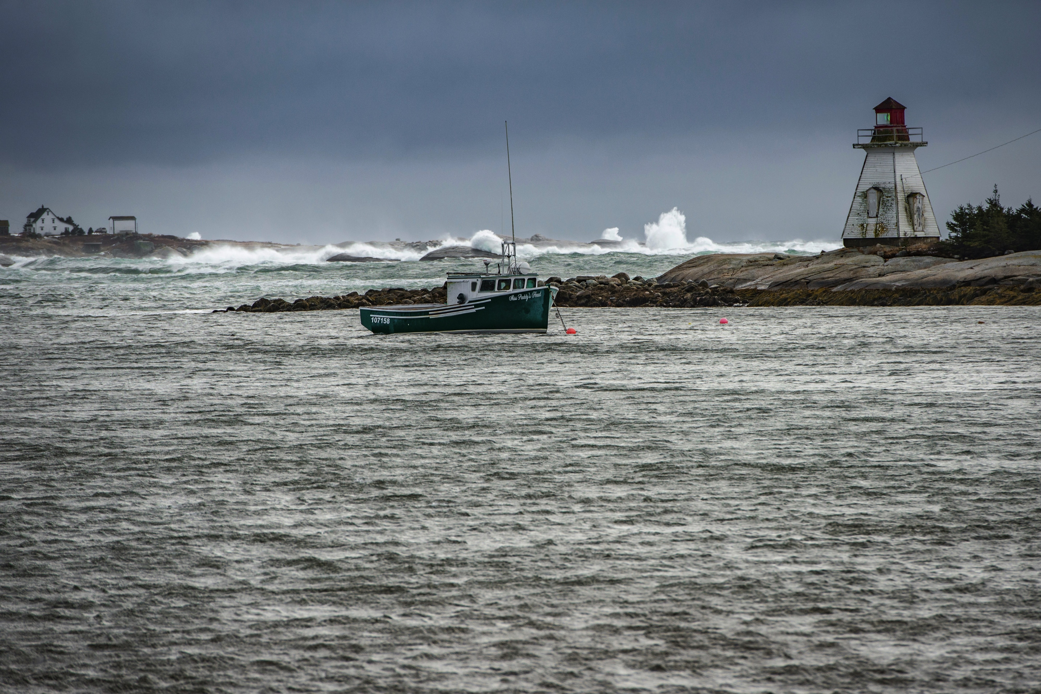
About Battle Harbor, Newfoundland and Labrador
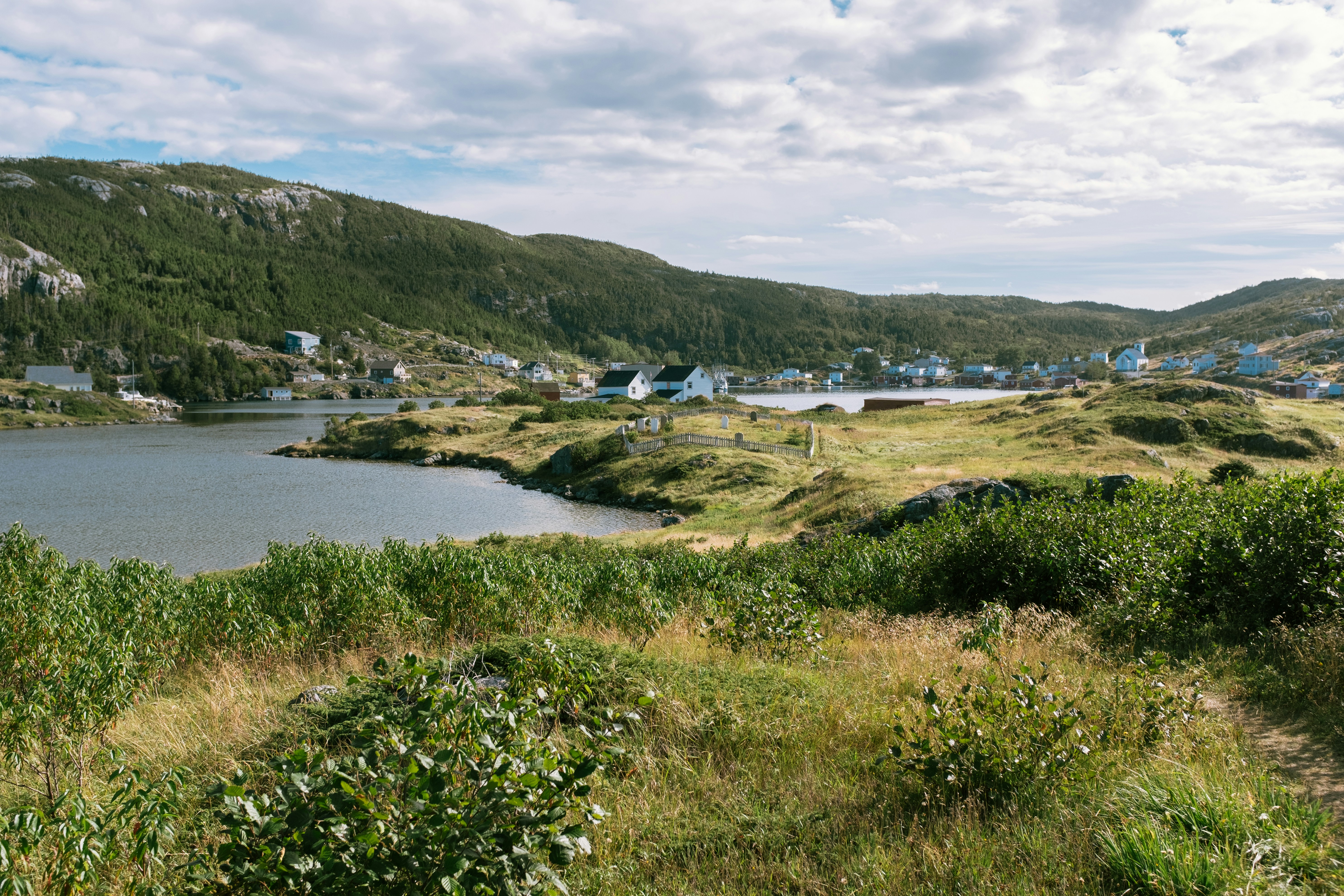
About L'Anse aux Meadows, Newfoundland and Labrador
Around the year 1000, Vikings from Greenland and Iceland founded the first European settlement in North America, near the northern tip of Newfoundland. They arrived in the New World 500 years before Columbus but stayed only a few years and were forgotten for centuries. Since the settlement's rediscovery in the last century, the archaeological site has brought tourism to the area. Viking themes abound but so do views, whales, icebergs, fun dining experiences, and outdoor activities. L'Anse Aux Meadows on the northern tip of the island of Newfoundland is a remote community of just 40 people, with St Anthony, 40 minutes away, having a population of only 3,500. The region is locally famous for springtime polar bears, nesting eider ducks, the northern extreme of the Appalachians at nearby Belle Isle, numerous spring and summer icebergs, and a rich ocean fishery. L’Anse Aux Meadows National Historic Site is the UNESCO World Heritage Site that tells the story of Leif Erickson and the first Europeans in the new world. This site is often the keystone attraction for cruises themed around the Vikings. Discovered in 1960, it is the site of a Norse village, the only known one in North America outside of Greenland. The site remains the only widely-accepted instance of pre-Columbian trans-oceanic contact, and is notable for possible connections with the attempted colony of Vinland established by Leif Ericson around 1003, or more broadly with Norse exploration of the Americas. The root of the name "L'Anse aux Meadows" is believed to have originated with French fishermen in the area during the nineteenth and twentieth centuries, who named the site L'Anse aux Meduses, meaning 'Jellyfish Bay'.
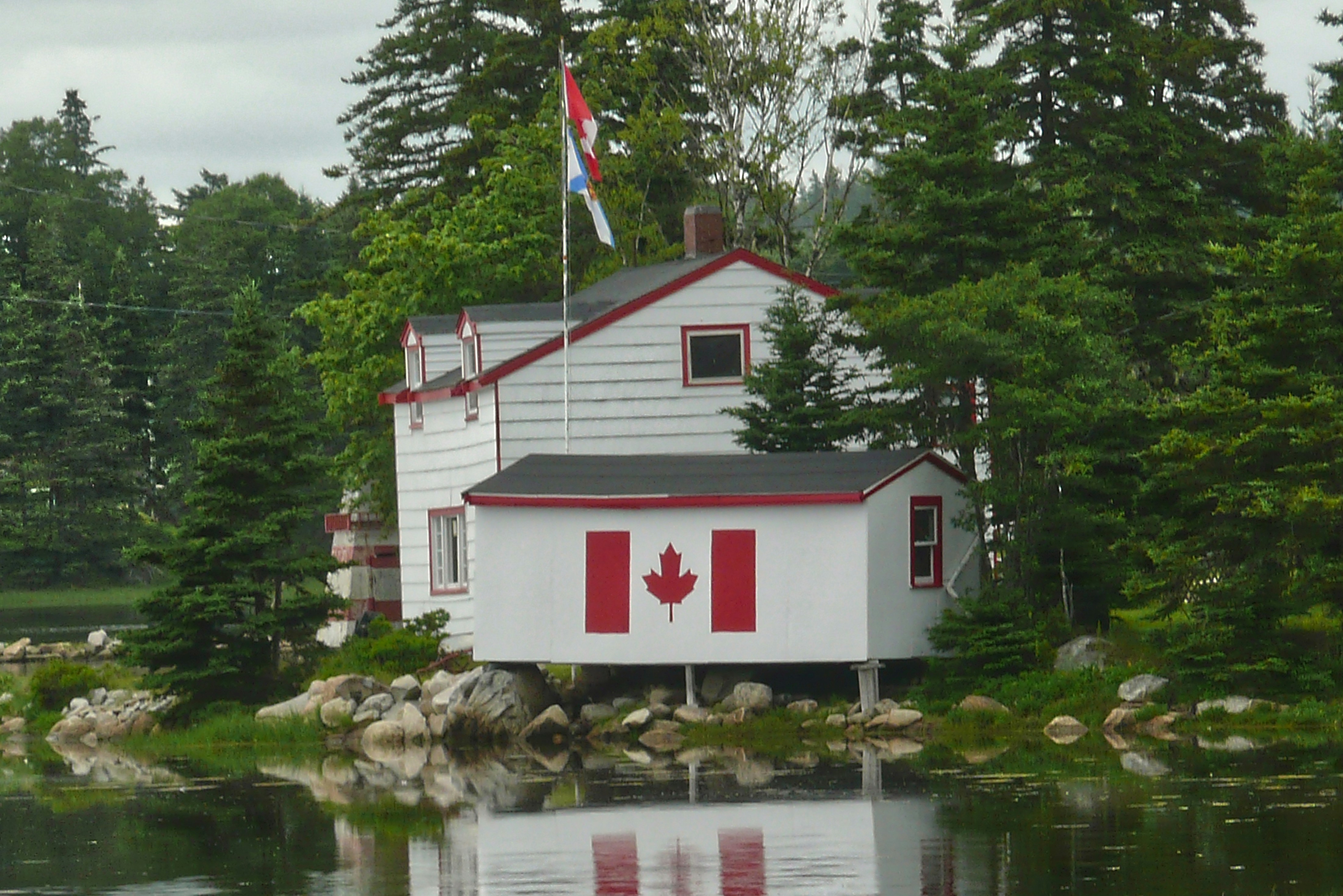
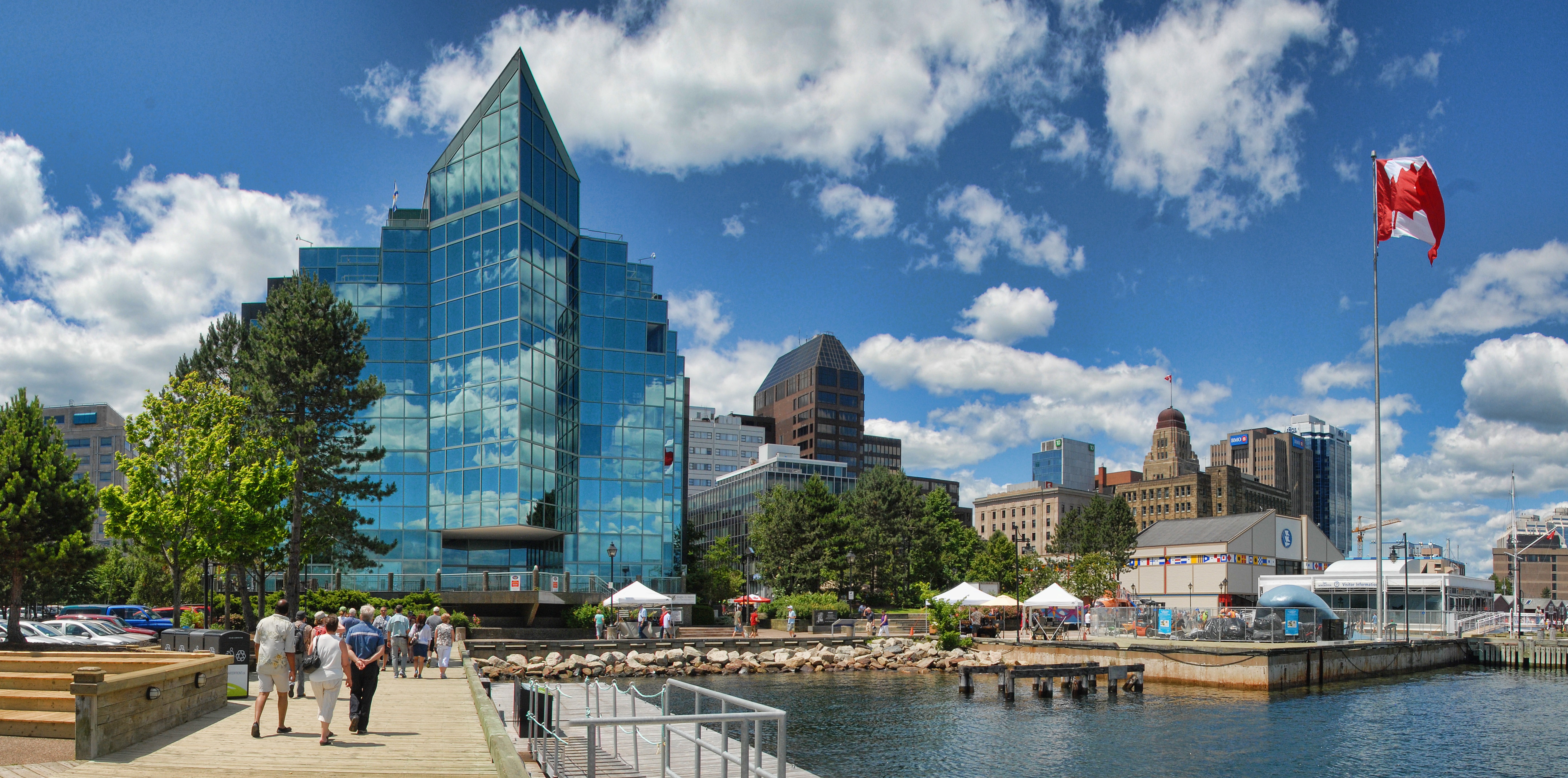
About Halifax, Nova Scotia
Surrounded by natural treasures and glorious seascapes, Halifax is an attractive and vibrant hub with noteworthy historic and modern architecture, great dining and shopping, and a lively nightlife and festival scene. The old city manages to feel both hip and historic. Previous generations had the foresight to preserve the cultural and architectural integrity of the city, yet students from five local universities keep it lively and current. It's a perfect starting point to any tour of the Atlantic provinces, but even if you don't venture beyond its boundaries, you will get a real taste of the region.It was Halifax’s natural harbor—the second largest in the world after Sydney, Australia’s—that first drew the British here in 1749, and today most major sites are conveniently located either along it or on the Citadel-crowned hill overlooking it. That’s good news for visitors because this city actually covers quite a bit of ground.Since amalgamating with Dartmouth (directly across the harbor) and several suburbs in 1996, Halifax has been absorbed into the Halifax Regional Municipality, and the HRM, as it is known, has around 415,000 residents. That may not sound like a lot by U.S. standards, but it makes Nova Scotia’s capital the most significant Canadian urban center east of Montréal.There's easy access to the water, and despite being the focal point of a busy commercial port, Halifax Harbour doubles as a playground, with one of the world's longest downtown boardwalks. It's a place where container ships, commuter ferries, cruise ships, and tour boats compete for space, and where workaday tugs and fishing vessels tie up beside glitzy yachts. Like Halifax as a whole, the harbor represents a blend of the traditional and the contemporary.
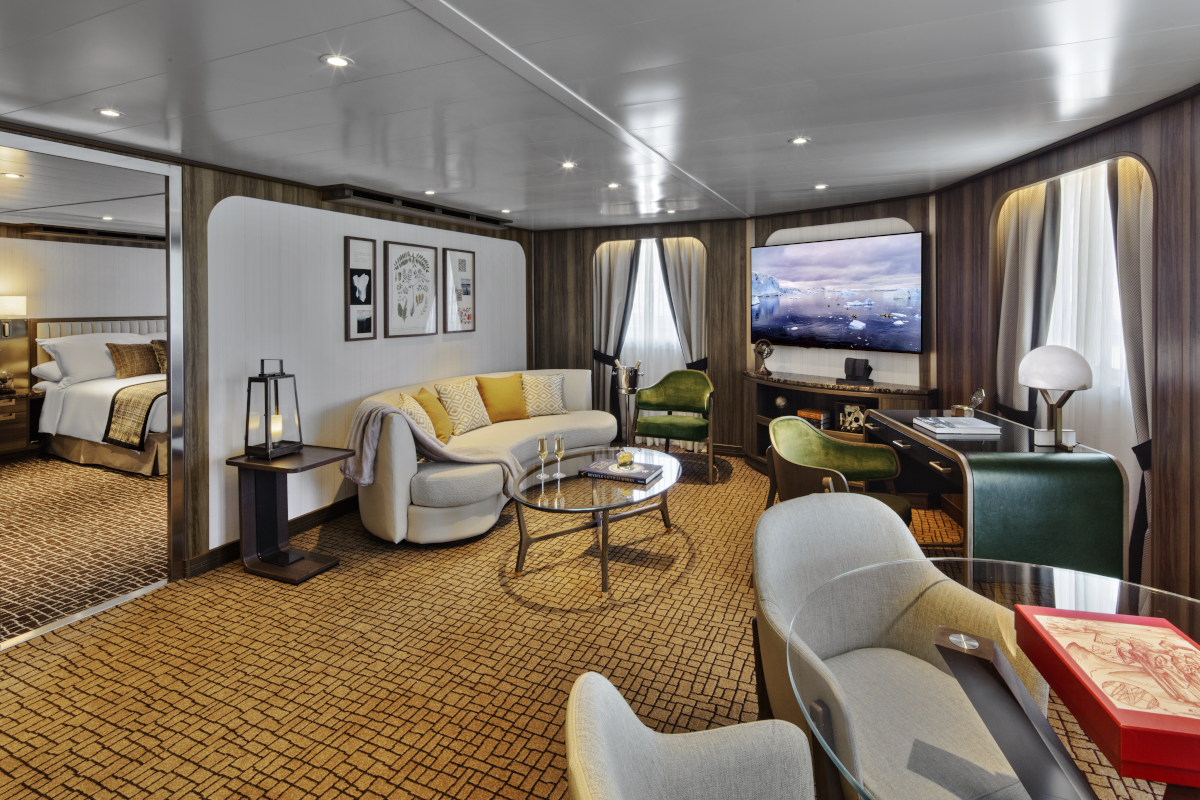
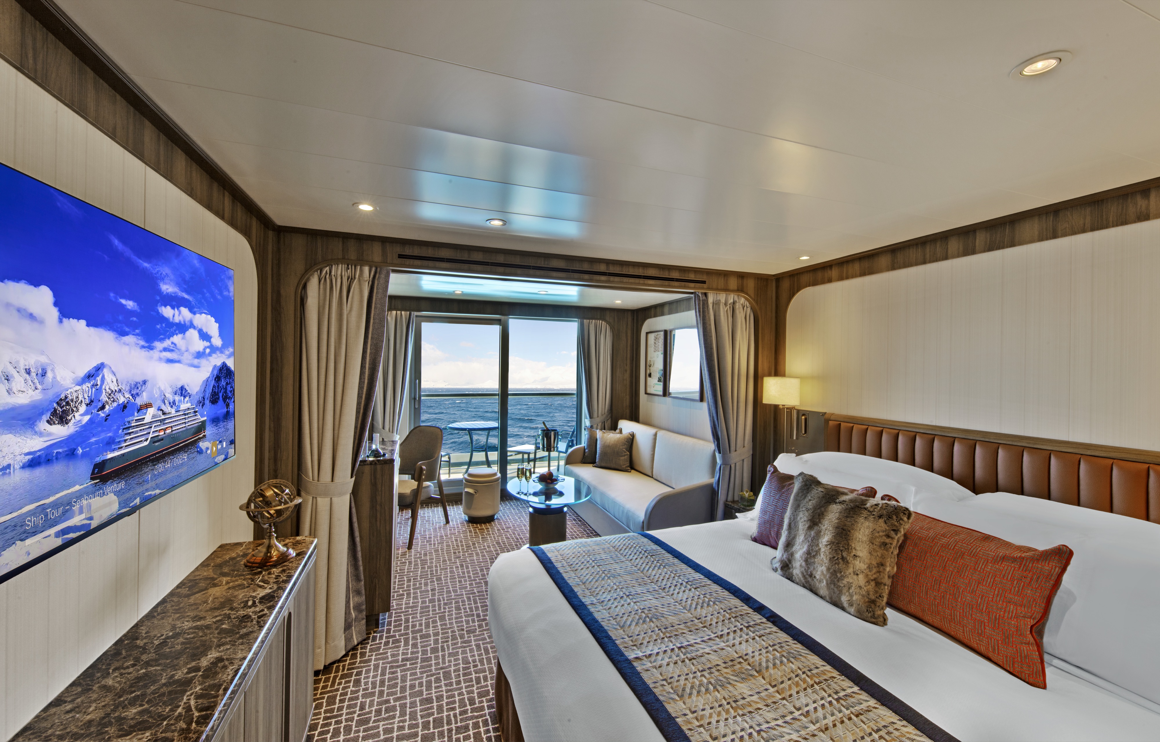
All Grand Wintergarden Suites onboard Seabourn Venture feature a comfortable living area; private veranda; queen-size bed or two twin beds; walk-in closet; personal safe; interactive TV with music and movies; fully stocked bar and refrigerator; writing desk with personalised stationery; makeup vanity; spacious bathroom, separate tub and shower, plush robes, slippers, luxury health and beauty products, hairdryer and 110/220V AC outlets.Expansive apartment-style suite stretching over two decks located midship. Entry opens to seamless double height views and generous lower level living area large enough for entertaining with a dining table for four, separate guest bath and pantry with wet bar stocked with a customised selection of spirits. Sculptured staircase leading to upper level and the master bedroom with a queen-sized Duxiana Axion 15 adjustable high-performance sleep system facing expansive windows, a wall of closets along with advanced technology including a roll-up LG OLED TV. Separate walk-in closet adjacent to the five-piece bathroom complete with a whirlpool spa tub and separate shower. Wintergarden suite guests also enjoy wildlife and vista spotting using a Swarovski ATX Interior spotting scope. The tripod-mounted scope, with its 25-60x85 lens capability, is for use in-suite while onboard. Entertainment experience features a high-end Bang & Olufsen Beolab 5 speaker system and Bang & Olufsen H4 Bluetooth headphones for guest use onboard.
- Large windows
- Dining for four
- Bathroom with whirlpool bathtub
- Guest bath
- Convertible sofa bed for one
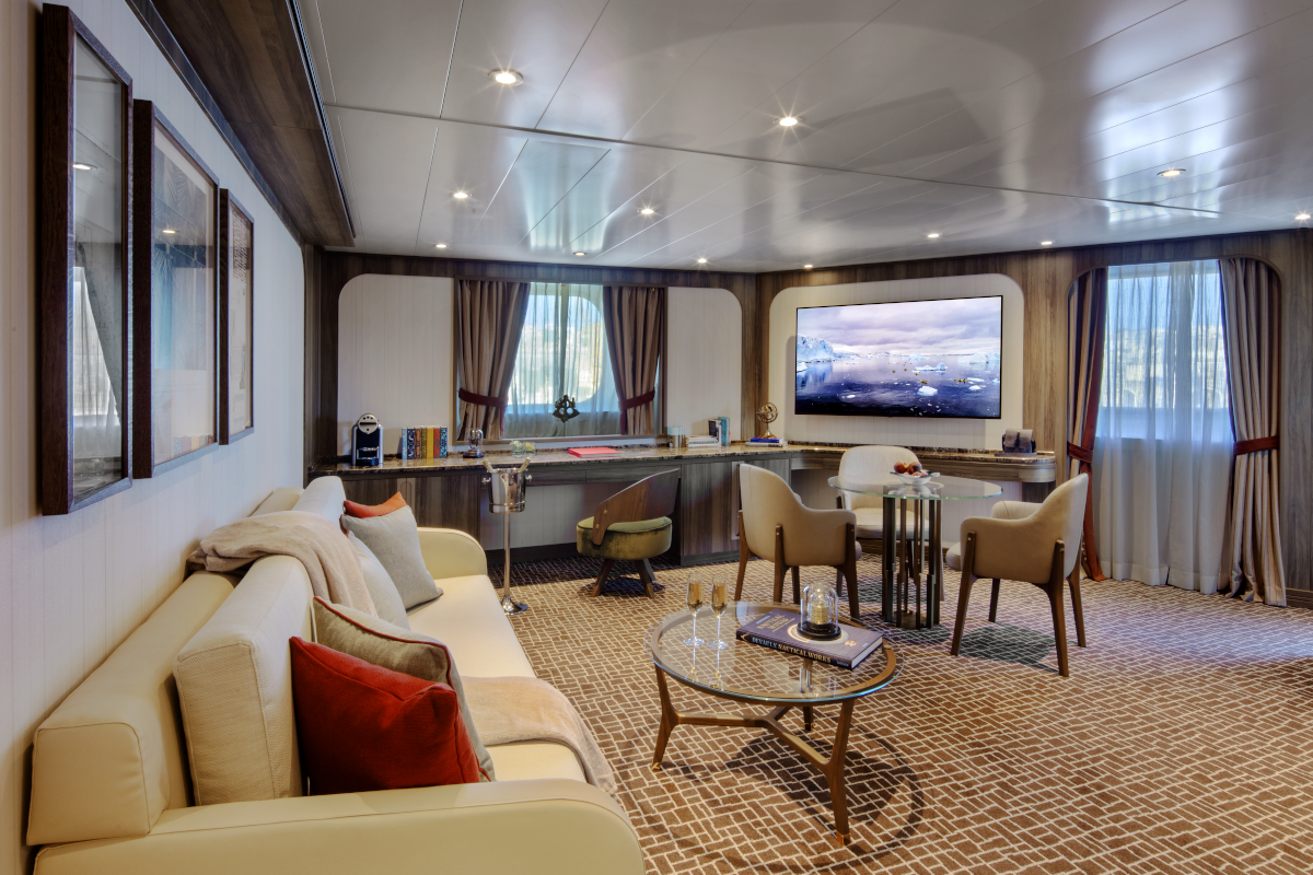
All Wintergarden Suites onboard Seabourn Venture feature a comfortable living area; private veranda; queen-size bed or two twin beds; walk-in closet; personal safe; interactive TV with music and movies; fully stocked bar and refrigerator; writing desk with personalised stationery; makeup vanity; spacious bathroom, separate tub and shower, plush robes, slippers, luxury health and beauty products, hairdryer and 110/220V AC outlets.Expansive apartment-style suite stretching over two decks located midship. Entry opens to seamless double height views and generous lower level living area large enough for entertaining with a dining table for four, separate guest bath and pantry with wet bar stocked with a customised selection of spirits. Sculptured staircase leading to upper level and the master bedroom with a queen-sized Duxiana Axion 15 adjustable high-performance sleep system facing expansive windows, a wall of closets along with advanced technology including a roll-up LG OLED TV. Separate walk-in closet adjacent to the five-piece bathroom complete with a whirlpool spa tub and separate shower. Wintergarden suite guests also enjoy wildlife and vista spotting using a Swarovski ATX Interior spotting scope. The tripod-mounted scope, with its 25-60x85 lens capability, is for use in-suite while onboard. Entertainment experience features a high-end Bang & Olufsen Beolab 5 speaker system and Bang & Olufsen H4 Bluetooth headphones for guest use onboard.Wintergarden Suite Features
Large windows
- Glass door to private veranda
- Comfortable living area
- Dining for four
- Separate bedroom
- Queen-size bed or two twin beds
- Walk-in closet
- Two flat-screen TVs
- Complimentary Internet/Wi-Fi service.
- Fully stocked bar and refrigerator
- Makeup vanity
- Guest bath
- Bathroom with whirlpool bathtub
*Wheelchair accessible suites are roll-in shower only.
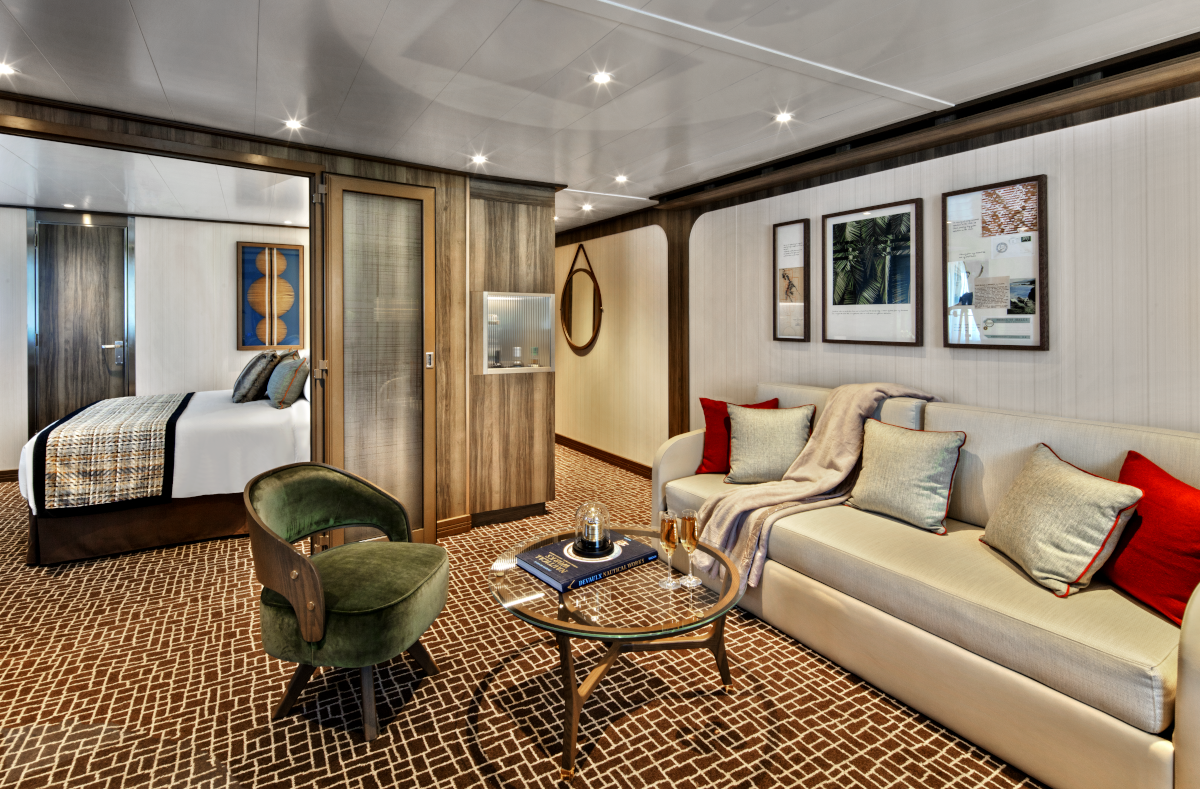
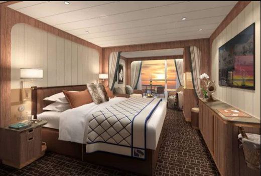
All Signature Suites onboard Seabourn Venture feature a comfortable living area; private veranda; queen-size bed or two twin beds; walk-in closet, personal safe; interactive TV with music and movies; fully stocked bar and refrigerator; writing desk with personalised stationery; makeup vanity; spacious bathroom, separate tub and shower, plush robes, slippers, luxury health and beauty products, hairdryer and 110/220V AC outlets.Foyer entry to living area with high-definition TV, dining table for four, guest bath, pantry with wet bar and large windows. Separate bedroom with queen-sized bed, makeup vanity, generous closet space and a glass door leading to a large curved 595 square foot veranda that includes its own canopied whirlpool spa tub, sun loungers, sofa and chairs. A five-piece bathroom with a separate shower and tub.
Signature Suite Features
- Large windows
- Glass door to private veranda
- Comfortable living area
- Dining for four
- Separate bedroom
- Queen-size bed or two twin beds
- Walk-in closet
- Two flat-screen TVs
- Complimentary Internet/Wi-Fi service.
- Fully stocked bar and refrigerator
- Makeup vanity
- Guest bath
- Bathroom with whirlpool bathtub
*Wheelchair accessible suites are roll-in shower only.
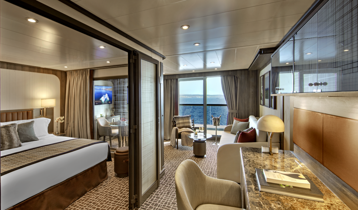
Owner's Suites on Seabourn Venture feature a comfortable living area; private veranda; queen-size bed or two twin beds; extra-large walk-in closet for expedition gear; personal safe; interactive flat-screen TV with music and movies; fully stocked bar and refrigerator; writing desk with personalised stationery; makeup vanity; spacious bathroom with double vanities, tub and shower, plush robes, slippers, hairdryer and 110/220V AC outlets.Entry with large closet to store gear and personal belongings. Comfortable living area with high-definition TV, writing desk and dining table for two for meals in-suite. Glass door leading to a curved veranda with sun loungers and a table for four. Separate bedroom with queen-sized bed has its own high-definition TV, a large window, makeup vanity and walk-in closet. Five-piece bathroom designed with multiple doors that can create a half-bath, and also features a separate shower and bathtub.Owner's Suite Features
- Large windows
- Glass door to private veranda
- Comfortable living area
- Dining for four
- Separate bedroom
- Queen-size bed or two twin beds
- Walk-in closet
- Two flat-screen TVs
- Complimentary Internet/Wi-Fi service.
- Fully stocked bar and refrigerator
- Makeup vanity
- Guest bath
- Bathroom with whirlpool bathtub
*Wheelchair accessible suites are roll-in shower only.
Suites 513-516, 611-614, 711-714, 802-805; Total space: 417 sq. ft. (39 sq. m.) incl. veranda of 85 sq. ft. (8 sq. m.) All Panorama Veranda Suites feature a comfortable living area; private veranda; queen-size bed or two twin beds; walk-in closet; personal safe; interactive TV with music and movies; fully stocked bar and refrigerator; writing desk with personalized stationery; makeup vanity; spacious bathroom, separate tub and shower, plush robes, slippers, luxury health and beauty products, hairdryer and 110/220V AC outlets. *Some veranda sizes vary.Panorama Penthouse Suite Features
- Large windows
- Glass door to private veranda
- Comfortable living area
- Dining for four
- Separate bedroom
- Queen-size bed or two twin beds
- Walk-in closet
- Two flat-screen TVs
- Complimentary Internet/Wi-Fi service.
- Fully stocked bar and refrigerator
- Makeup vanity
- Guest bath
- Bathroom with whirlpool bathtub
*Wheelchair accessible suites are roll-in shower only.
Approximate total space: 527 sq. ft. (49 sq. m.) including veranda of 97 sq. ft. (9 sq. m.) All Penthouse Suites feature a comfortable living area; private veranda; queen-size bed or two twin beds; walk-in closet; personal safe; interactive TV with music and movies; fully stocked bar and refrigerator; writing desk with personalized stationery; makeup vanity; spacious bathroom, separate tub and shower, plush robes, slippers, luxury health and beauty products, hairdryer and 110/220V AC outlets.
Penthouse Suite Features
- Large windows
- Glass door to private veranda
- Comfortable living area
- Dining for four
- Separate bedroom
- Queen-size bed or two twin beds
- Walk-in closet
- Two flat-screen TVs
- Complimentary Internet/Wi-Fi service.
- Fully stocked bar and refrigerator
- Makeup vanity
- Guest bath
- Bathroom with whirlpool bathtub
*Wheelchair accessible suites are roll-in shower only.
- Dining table for two to four
- Separate bedroom
- Glass door to veranda
- Two flat-screen TVs
- Fully stocked bar
- Spacious bathroom with tub, shower and large vanity
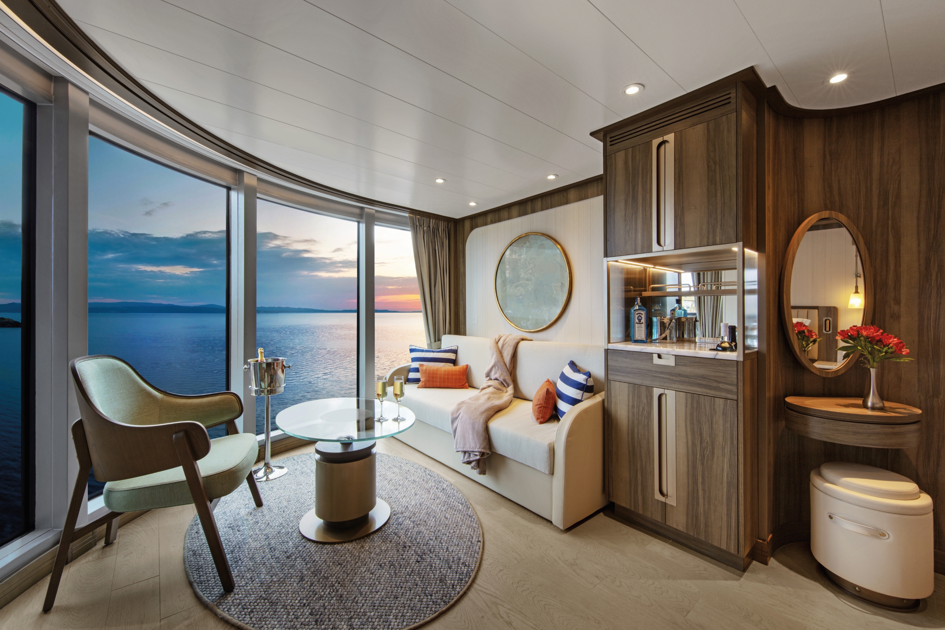
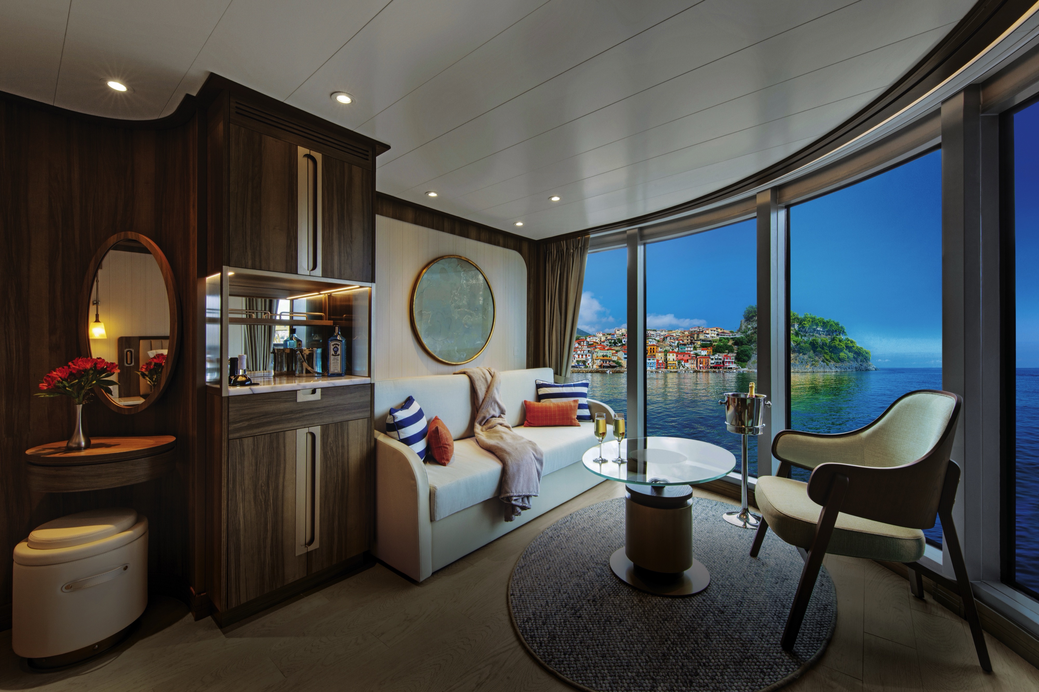
All Panorama Veranda Suites onboard Seabourn Venture feature a comfortable living area; private veranda; queen-size bed or two twin beds; walk-in closet; personal safe; interactive TV with music and movies; fully stocked bar and refrigerator; writing desk with personalised stationery; makeup vanity; spacious bathroom, separate tub and shower, plush robes, slippers, luxury health and beauty products, hairdryer and 110/220V AC outlets. Semi-circular separate living area with comfortable seating and expansive floor-to-ceiling windows. Queen-sized bed or twin beds oriented to face the windows to enjoy views of beautiful scenery and gorgeous sunrises and sunsets. Bathroom features a separate shower and large soaking tub placed next to a wide window.*Some veranda sizes vary.

Penthouse Spa Suites on board feature a comfortable living area, glass door to private veranda, queen-size-bed or two twin beds; walk-in closet with personal safe, interactive flat-screen TV, fully stocked bar and refrigerator and spacious marble bath with double vanities.
Approximate total space: 355 sq. ft. (33 sq. m.) including veranda of 75 sq. ft. (7 sq. m.)* Suites on Seabourn Venture feature a comfortable living area; private veranda; queen-size bed or two twin beds; extra-large walk-in closet for expedition gear; personal safe; interactive flat-screen TV with music and movies; fully stocked bar and refrigerator; writing desk with personalized stationery; makeup vanity; spacious bathroom with double vanities, tub and shower, plush robes, slippers, hairdryer and 110/220V AC outlets.
- A large picture window
- Comfortable living area
- Queen-size bed or two twin beds
- Walk-in closet
- Interactive flat-screen television with music and movies
- Fully stocked bar and refrigerator
- Spacious bathroom with separate tub and shower.
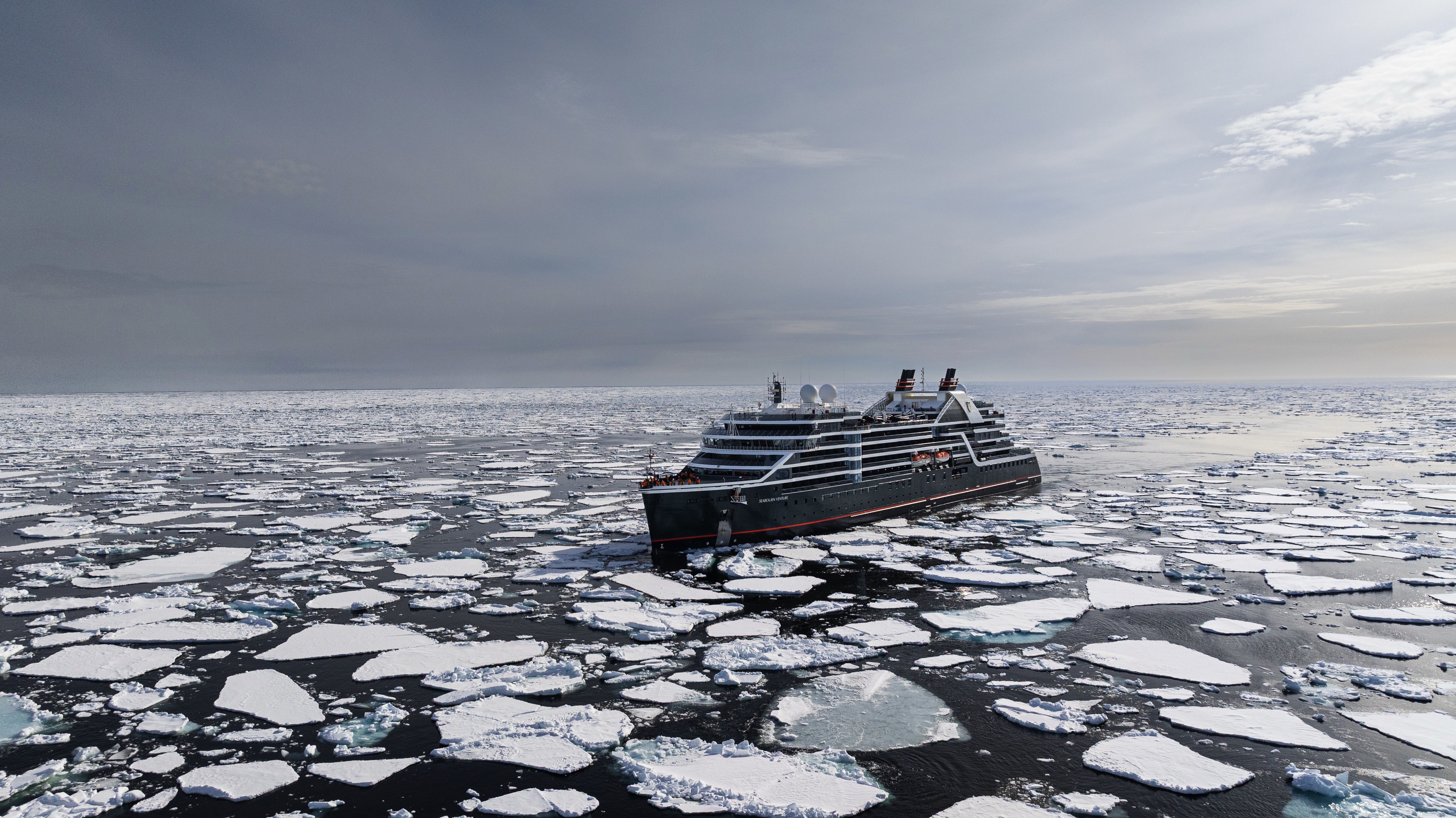
Seabourn Venture
Our first ultra-luxury, purpose-built expedition ship, Seabourn Venture offers the same luxurious small ship experience that travelers have come to expect from Seabourn, while transporting guests to the most coveted, remote destinations in the world.
Launched in 2022, Seabourn Venture is designed and built for diverse environments to PC6 Polar Class standards and includes modern hardware and technology that will extend the ships’ global deployment and capabilities. She and her sister ship Seabourn Pursuit each 24 Zodiac® boats, kayaks, and a 23-person expert Expedition Team enabling guests to engage in up-close wildlife encounters, off-the-beaten-path excursions, and enriching cultural experiences. A fully-inclusive yacht-like experience, Seabourn Venture blends state-of-the-art capability with world-class service and luxury.
Learn more about Seabourn's first purpose-built, ultra-luxury Expedition ship. Truly a state-of-the-art vessel, Seabourn Venture's private yacht-like atmosphere, and incredible design details seamlessly blend the worlds of ultra-luxury cruising and expedition exploration into an intimate utopia of discovery.
Ship Facts
| Launch Year | 2022 | ||||||||
| Refit Year | |||||||||
| Language | en | ||||||||
| Gross Tonnage | 23000 | ||||||||
| Length | 170 | ||||||||
| Width | 24 | ||||||||
| Currency | USD | ||||||||
| Speed | 19 | ||||||||
| Capacity | 264 | ||||||||
| Crew Count | 120 | ||||||||
| Deck Count | 8 | ||||||||
| Cabin Count | 132 | ||||||||
| Large Cabin Count | N/A | ||||||||
| Wheelchair Cabin Count | 5 | ||||||||
| Electrical Plugs |
|
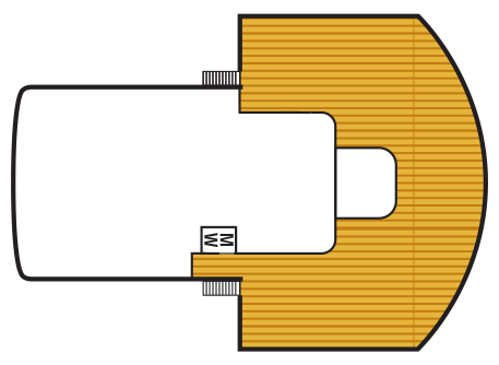
To see the legend for these deck plans, please hover your mouse over the images below
To toggle the legend for these deck plans, please tap on any of the images below
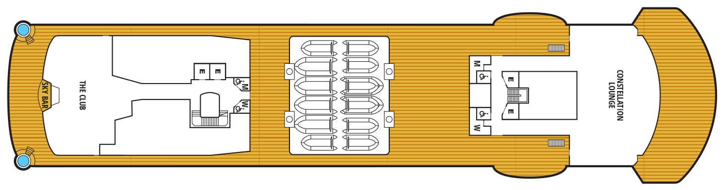
Deck 10
- Sun deck
Deck 9
- Constellation Lounge
- The Club
- Sky Bar
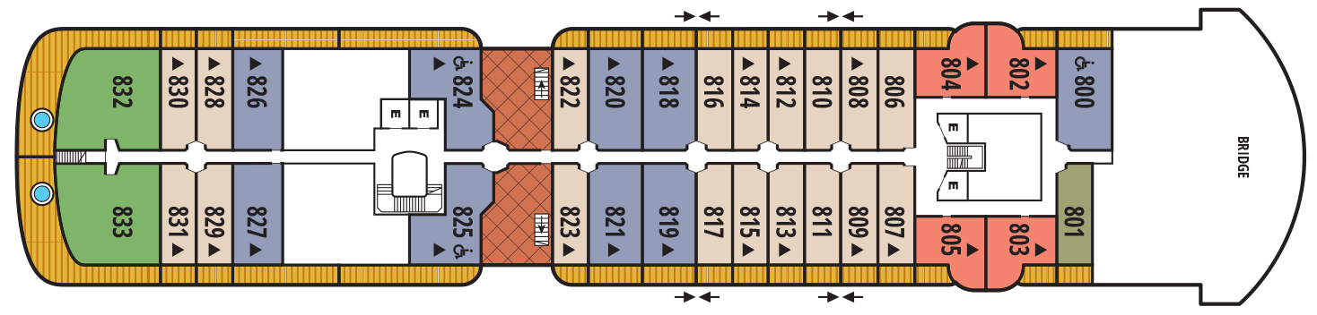
Deck 8
- Bridge
- Wintergarden Suite
- Signature Suite
- Penthouse Suite
- Veranda Suite
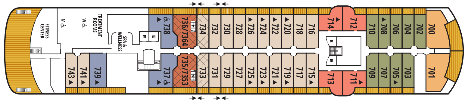
Deck 7
- Spa & Wellness Area
- Treatment Rooms
- Fitness Centre
- Grand Wintergarden Suite
- Penthouse Panorama Suite
- Penthouse Suite
- Owner's Suite
- Veranda Suite
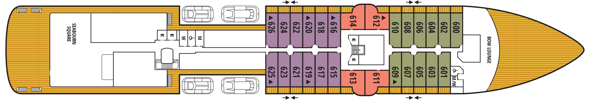
Deck 6
- Bow Lounge
- Seabourn Square
- Penthouse Panorama Suite
- Veranda Suite
Deck 5
- Meeting Room
- The Colonnade
- The Patio
- Infinity Pool
- Penthouse Panorama Suite
- Verandah Suite
Deck 4
- The Studio
- Discovery Centre
- Expedition Lounge
- Shop
- The Restaurant
Deck 3
- Medical Facility
- Zodiac Embark
- Landing Zone

Complimentary world-class dining experiences range from the adventurous to the familiar, yours to choose from to suit your mood. Dine when, where, and with whom you choose, with no tipping expected nor required. Our skilled and talented chefs expand your awareness of the places you travel by creating dishes with locally sourced ingredients, techniques and specialties. Complimentary spirits and fine wines selected by our Sommeliers are yours for the asking as well, any time
The Restaurant
Before Seabourn, open-seating dining on a cruise ship was unheard of. Come when you like, with whom you please, and be seated as you wish. The room is beautiful, the cuisine is exquisite, and the service is simultaneously flawless, friendly and fun.
The Colonnade
Our more casual, indoor/outdoor alternative, features an open kitchen, lavish buffets or table service for breakfasts and lunch, and serves regionally themed, bistro-style dinners with table service nightly.
The Patio
Constellation Lounge
The Constellation Lounge is the highest indoor viewing point on each ship. Floor-to-ceiling glass walls wrap around the space, offering guests stunning 270-degree, outward-facing views as far as their eyes can see, heightening their expeditionary spirit while bringing them closer to wildlife and wonders at sea and in port.
In addition, the expedition team will be in the lounge regularly to help identify points of interest, wildlife and geological wonders. Imagine glimpsing killer whales, waddling penguins, and sea lions in Antarctica; sleepy-eyed sloths, sprightly monkeys, and colorful parrots in the rainforests of South and Central America; and icebergs bobbing in the seas and waterfalls rushing over cliffs in the far reaches of the Arctic and Northern Europe – all from the comfort of the Constellation Lounge.
The Constellation Lounge offers Seabourn’s popular Early Morning Riser continental breakfast, while afternoons features the line’s popular and recently enhanced Afternoon Tea service. Steeped in the tradition of proper English tea service, yet as fresh and memorable as a newly brewed pot, the elegant daily tea service incorporates the finest luxury tea brand TWG Tea. As the sun dips and the night sky lights up, live piano entertainment delights guests as cocktails and tapas are served both before and after dinner.
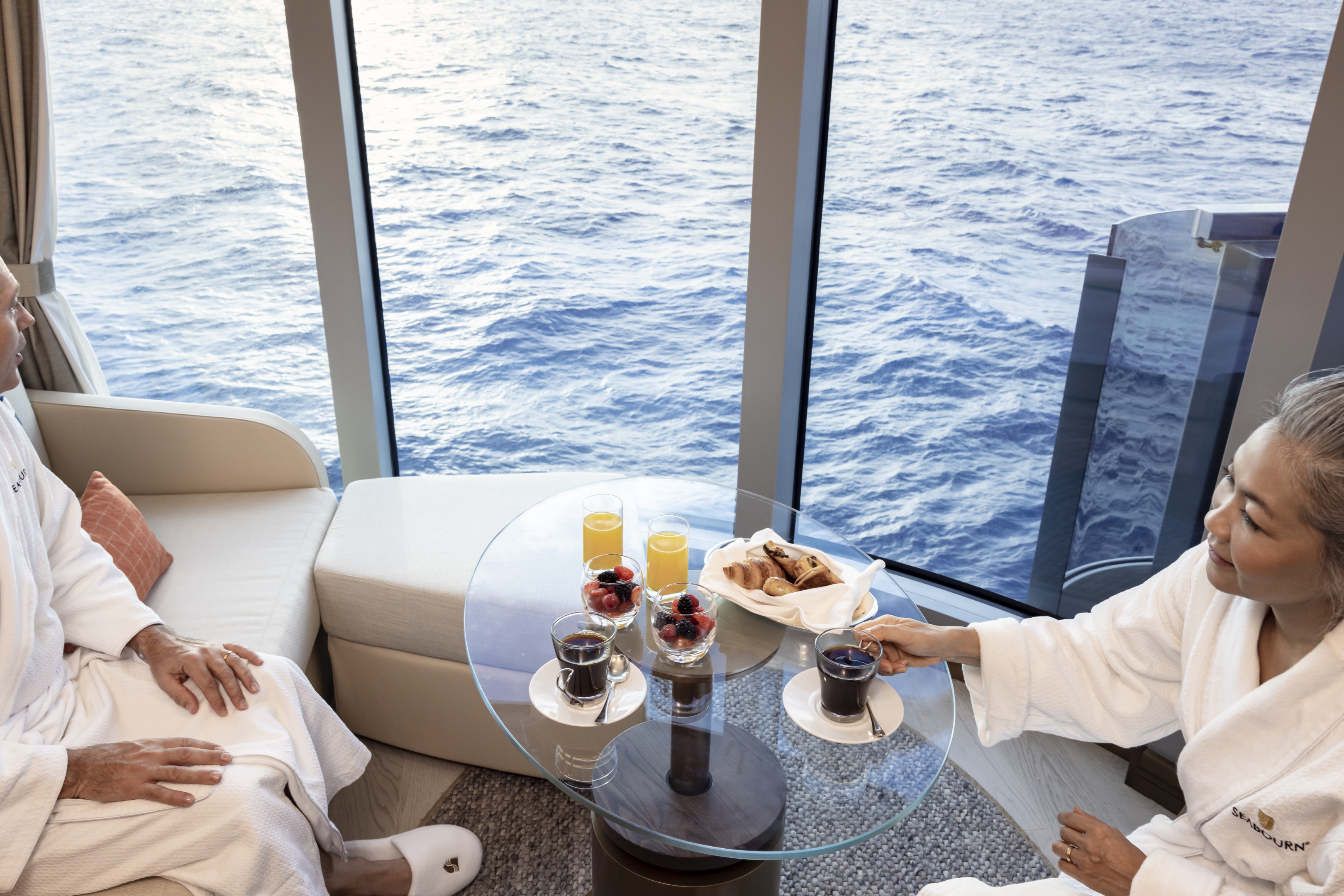
In-Suite Dining
Seabourn is pleased to offer a varied menu available around the clock for service in your suite. You may also order dinner from The Restaurant menu and have your meal served, course by course, in your suite or on your veranda.
Earth & Ocean
Each evening, our skilled Earth & Ocean chefs create an imaginative array of fresh, inventive dishes—a sophisticated menu celebrating eclectic traditional flavors from around the world, served in a relaxed setting under the stars for a distinctive dining experience unlike any other on board.
In every area of the ship, an elegant aesthetic awakens the senses to capture the romanticism of early explorers and the thrill of discovery.
Expedition Lounge
The Expedition Lounge, located on Deck 4, is the heart of the ship. A gathering place for the curious, guests are invited to relax or linger with a complimentary cocktail or glass of fine wine from the bar as they share photos and stories from the day with their fellow travelers and the onboard staff. The Expedition Lounge will be central to the Seabourn expedition operation where guests convene before and after expeditions each day.
Custom furniture designed in a variety of warm, natural materials creates an inviting, tactile atmosphere. An ode to the adventurous, the Expedition Lounge features an etched glass partition displaying a vintage map of Antarctica and vitrines showcasing intricate tools and devices of the trade. Two large touchscreens will also display a wealth of information including photos, navigational charts, weather charts, and maps.
The Club
The liveliest lounge on board is the scene of daily afternoon tea service. It is a popular spot for pre-dinner drinks and dancing to live music. After dinner, the dancing music continues, and later a DJ spins dance music until late at night. Another terrace of open deck aft of The Club boasts a plunge pool and two small whirlpool spas.
Seabourn Sojourn, Seabourn Quest, Seabourn Venture, and Seabourn Pursuit offer Sushi in The Club, serving a variety of light sushi bites freshly made to order each evening.
Seabourn Square
A place to enjoy some light reading or to socialize with your fellow passengers, Seabourn Square is what you're looking for. Seabourn Square is the true ‘living room’ of the ships. An inviting sociable space where guests will find a charming European style coffee bar, Seabourn Square has been designed as an open, comfortable environment for guests to interact with onboard officers and the expedition team and engage in conversation with family and new friends. The space is also home to the highly-trained Guest Services staff, who provide a range of concierge services such as general ship information, assistance with special service requests, port and travel information, and more.
A selection of coffees are prepared by the skilled onboard baristas some using beans roasted in Seabourn Square. For those feeling a bit hungry, Seabourn Square offers freshly made pastries and other on-the-go breakfast items in the morning, as well as an assortment of light sandwiches and desserts later in the day, along with a selection of artisanal gelati made on board. Guests will also find a wide range of books in the adjoining library, with a host of titles on subjects such as adventure, expeditions and other topics of interest to enjoy while onboard. Staying current with the news is made easy with tablets featuring the Press Reader news application available to browse each day.
Bow Lounge
Located on Deck 6, at the forward-most part of the vessel, the Bow Lounge provides the closest access to water level via the foredeck, making it the perfect spot for guests to spend some time watching for marine life. Within a few steps, guests can be outside, with a vantage point that is ideal to watch the ship’s course, spot wildlife, or take in the beautiful natural scenery.
The Bow Lounge introduces some technological enhancements, providing guests with a first for Seabourn with touch screens showing the ship’s plotted location, as well as navigational charts and scientific information used to help guide the ship on its journey. Large screens project live footage from mounted cameras outside the ship, and from a drone when conditions permit, while the touch screen monitors invite guests to explore on their own with a live map, weather information, and notes detailing upcoming expeditions. Expedition Team members will be available within the Lounge throughout the day to interact with guests, answer questions, provide interpretation and aid in spotting wildlife.
The space provides direct access to the Bow Sprit on Deck 6 forward (when conditions permit) to give guests the sensation of standing in front of the ship and views of waves parting and ice sloughing off the bow at the waterline.
Sky Bar
Overlooking the beautiful Pool Patio, the open-air Sky Bar presents you with a gorgeous setting to take a break from the afternoon sun while enjoying a refreshing tropical beverage, or spend the evening enjoying a few social cocktails under the stars.
Evenings Under The Stars
One of the most FUN evenings during any cruise, Evenings Under the Stars is a night where guests can let their hair down and simply be in the moment. Enjoy Let’s Dance! with great live music, interact with fellow travelers and be spoiled in true Seabourn style by our food and beverage team with Desserts Under the Stars. A signature event, this dance party has been a part of the line’s rich culture, and a Seabourn cruise is not complete without Let’s Dance! and Desserts Under The Stars.
Weather permitting, this high-energy dance party is hosted poolside and under the stars by the entire entertainment team, featuring performances by The Band, vocalists and dancers. There is even the possibility your Cruise Director and Assistant Cruise Director might jump on stage to perform, as well! Guests can expect music that appeals to everyone’s taste with a great mix of hit songs. It’s a real treat and guests LOVE Evenings Under the Stars!
Card Room
Many veteran cruisers specifically choose cruises that provide at least a few days at sea. The Card Room is a great choice for the sea-loving cruiser who craves that languorous feeling of lazy leisure. There will be loads of on board activities during those days, including a great game of bridge.
Meeting Room
For meetings and gatherings, our ships offer meeting rooms that can accommodate up to 40 guests. The meeting rooms can be arranged to guests’ specifications including theater-style or with tables; and each of the rooms have large-screen TVs for presentations. Guests may also reserve the Card Room when available. Our crew members are happy to assist guests with meeting room reservations and setup.
Onboard Shopping
Whether you're buying souvenirs for your friends at home or want a memento of your vacation, our Shops will have what you need. Shop for fashion and cosmetics at The Boutique, jewelry and fine watches at The Collection, or logo cruisewear at the Shop.
Zero @ Sea
A Zero-proof cocktail experience featuring a unique array of non-alcoholic cocktails
Zero @ Sea offers an inventive menu of mixology cocktails, with ingredients and flavors free of alcohol, such as elderflower, bursts of fresh citrus, botanical spirits, and more.
Zero @ Sea cocktails are available fleetwide in all bars and lounges aboard the ships together with an upgraded selection of nonalcoholic wines, sparkling wines, and beers.
The new cocktails were developed by Seabourn’s expert culinary and beverage team, led by Michael Simon, senior manager of restaurant and bar operations, and Francisco Fernandes, corporate manager service operations.